The Land Acquisition ProcessAcquiring vacant land in Colonial Pennsylvania was a multi-step process. First the prospective landowner had to go to the Land Office in Philadelphia and apply for a warrant for a specified acreage of land in a certain area. The Office made various checks, including whether there was enough vacant land in the requested area, before issuing a warrant. This gave you a right to a certain amount of land. For the next stage of land acquisition the warrantee took the warrant to the official surveyor for the area concerned. In the case of northern Chester County the surveyor in the first decades of Pennsylvania’s existence was David Powell. The surveyor, for a fee, surveyed an area of vacant land corresponding to the warrant. The survey was then filed at the Land Office. A fee for the land would then be paid before the patent was issued that defined the ownership of the parcel of land. This was not a freehold purchase but a type of perpetual lease and an annual quit rent (a type of property tax) was due to the Proprietors. In addition the landowner was also actually given 6% more land than purchased which was an allowance for roads across the property. The other stipulation was that one fifth of all the gold and silver mined on the property was due to the Proprietor. No such minerals were ever mined in Pennsylvania during the Colonial Period. Normally people went through the stages quickly but occasionally years would lapse between the stages. In some cases the purchaser would die before he had the patented land. In that case the right would be passed on to the inheritors by the will or administration. The North Valley HillsIn Tredyffrin the land in the Great Valley was the first to be settled, being the prime agricultural land. Next settled was the land of the South Valley Hills. Some plots that included the Lancaster Road were acquired earlier. The last area to be settled was the North Valley Hills. By the 1760s all the land in Tredyffrin had been settled except for areas north of Yellow Springs Road. The two people who initiated the major purchases on the North Valley Hills were Israel Davis and Francis Alison. Israel Davis lived in Tredyffrin and was involved in running St. Peter’s Mill with his father, James Davis. The Reverend Francis Alison purchased 400 acres of land from Lewis James in 1753 [Note: The deed has not been found (date 4/4/1753) but quoted is in mortgage H-550, Rev. Francis Alison to Lewis James, dated 4/15/1753.]. The property had a western boundary of North Valley Road. Alison was not a Tredyffrin resident but he was a Presbyterian Minister who lived in Philadelphia. He did not hold onto the property for long and by the end of 1760 he had sold all of this land except for a meadow by Valley Creek. In February 1765 Israel Davis obtained a warrant for 210 acres of land in the name of the Proprietors (the Penn family). This land had the township boundary as its northern edge (see map). Ten days later Alison took out a 50 acre warrant on a tract south of the 210 acres [Note: Warrants D-63 (Israel Davis) and A-37 (Francis Alison). When the Alison tract was surveyed it turned out to have an area of 56 acres (Survey B11-122).]. There were two additional tracts on the North Valley Hills that took a long time to be acquired. These tracts were east of the 210 acres of Proprietors’ Land. The first covered 39 acres. James John obtained a warrant on the tract in 1759, Samuel and John Potts had it surveyed in 1765, but it was not until 1796 that Henry Zook patented the property. The other tract was of 96 acres. John Mather obtained a warrant and had the property surveyed in 1757. It was patented by Isaac Potts in 1791. | ||
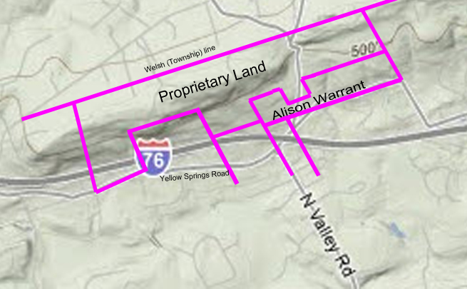 | ||
A survey of the 210 acres of Proprietary Land was filed a couple of days after Alison acquired his warrant. In 1766 the Pennsylvania Board of Property allocated the land to the 4 landowners who owned the adjacent properties towards the south: James Davis, John Maxwell, David Jones, and Francis Alison for the standard price of £50 sterling per 100 acres and an annual quit rent of a halfpenny sterling per acre (Note: Board of Property, 5/26/1766 minute book #1, page 30. It is strictly incorrect to say that Francis Alison owned land south of the Propriety Land in 1766. He had taken out a warrant for land in 1765 but had not patented it. Also he had sold his property south of this in 1759. A survey including this allocation was filed in December 1766.) The potential owners met this allocation of land to themselves with – indifference (even Francis Alison!). None of them completed the process of acquiring the land. Instead the process stalled for 20 years. The area of the Alison warrant was eventually allocated to the land owners to the south in a similar way to the Proprietary Land. The sub-division of the land is shown in the following plan: | ||
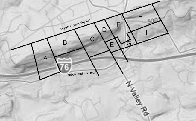 | ||
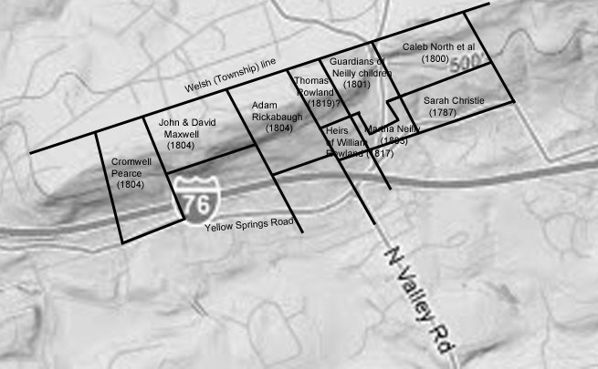
In the period between the allocation of the land and 1785, when the next steps in the land acquisition process were initiated, the ownership of the properties to the south changed hands. Additionally, as part of setting up the Commonwealth of Pennsylvania after the Revolutionary War, unsettled lands were acquired by the Commonwealth. The proprietary tracts continued to be owned by the Penn family, causing confusion in the land acquisition process. In 1784 Edmund Physick, the Penn family attorney, (and a one-time Tredyffrin resident) made a list of the proprietary tracts (Reference: J. Smith Futhey & Gilbert Cope, History of Chester County Pennsylvania, p. 152, Louis H. Everts, 1881). The total area of the tracts was a lot less than the 1 acre in 100 acres that the proprietor reserved for himself in the articles of the Colony. Whether this was due to missing tracts or the fact that the specified acres were never assigned to the family is not clear. The 210 acre tract was included in the list of proprietary tracts. In 1785 Sarah Christie and Matthew Neilly, who owned property south of the Alison tract, had the tracts surveyed (Surveys B8-240 and A82-12.) that had been assigned to them under the rights of Francis Alison (tracts G and I in the above plan). Matthew Neilly then succumbed to the ennui affecting the other potential land owners and did not complete the purchase by acquiring a patent. Sarah Christie did complete the process and in 1787 patented 31 acres she called ‘Magne Stone’ [This may be a typo and perhaps should be ‘Magnet Stone’] (Tract I, being part of the Alison 50 acre tract), patent P16-447. Sarah did not complete the purchase on the 29 acres that was her allocation of the 210 acre tract. That acquisition did not occur until 1800, when Caleb North, Charles Jolly and Robert Porter acquired the tract from the Penn family (tract H). [Note: This was a complex transaction. Firstly, in 1799, John and David Christie sold their property to Caleb North, Charles Jolly, and Robert Porter. These gentlemen then bought from the Penn family the tract of 29 acres 120 perches north of the land they had just purchased. On completing the purchase in 1800 the three immediately sold it back to John Christie who then divided the property in two and sold it to Israel Davis and Thomas Jones, these transactions all being completed in one week.] They were obviously in cahoots with John and David Christie, who then owned the Christie home tract, as the 29 acres eventually ended up in the ownership of John Christie. The Neilly allocation was acquired in two parts. In 1801 Robert Todd and David Wilson acquired 24 acres (tract F) out of the 210 acres in trust for the 5 Neilly minors (Matthew Neilly having died) - [Note: Deed W2-471, 8/1/1801, John Penn et al to Robert Todd and David Wilson, guardians, in trust for the 5 minor children of Matthew Neilly.] Then in 1803 the Neilly children patented 13 acres of the Alison tract (Patent P51-58), calling it ‘New Garden’ (tract G). The next acquisition to be completed after the Christie tract was in 1791, being 35 acres at the west end of the 210 acre plot (tract A). This was patented in the names of Mary and Isabella Bull, but since they were in their minority it was probably their mother Sarah Bull who completed the process. She had been recently widowed and the tract was called “Widow’s lot” (patent P18-59). Since the property was actually owned by the Penn family rather than the Commonwealth, the patent was invalid. In 1796 Adam Rickabaugh acquired 58 acres of the 210 acres through the patent process (patent P27-346), calling the tract ‘Mansfield’ (tract C). It was in 1804 that the problems of acquisitions by the patent process of sections of the 210 acre tract, rather than through the Penn family, were resolved. In a series of deeds dated the 5th December 1804 the allocations of James Davis, John Maxwell, and David Jones were acquired by Cromwell Pearce (husband of Isabella Bull), John Maxwell junior, and Adam Rickabaugh respectively (tracts A, B, and C). Tract A: The Cromwell Pearce deed transactions were actually more complicated. Cromwell and Isabella first sold the property to John Maxwell who then sold the property back to Cromwell alone clearing his wife’s name from the title. He then acquired the property from the Robinsons (Richard & Mary, nee Bull) and the Penns in his name only (John Penn et al to Cromwell Pearce. Deed Y2-253, 12/5/1804 of 35¼ acres 36 perches). The tardiest of the potential land owners were the Rowland family. It was not until 1817 that the heirs of William Rowland patented the final 12 acres of the Alison warrant (tract E) [ Survey C2-170 dated 8/21/1801 and patent H15-380, dated 3/3/1817]. The ‘acquisition’ in 1819 of the final part of the 210 acre tract was very strange (tract D). Rather than a deed transferring the land from the Penn family as was done with the other tracts there is only a receipt for $3 of quit rent (which had been abolished in the Divesting Act of 1779). The Receipt was recorded as Deed P3-461, dated 8/3/1819 So after a long process lasting over 50 years all the land in the North Valley Hills was settled. The following plan shows the eventual owners and acquisition dates. | ||
 | ||