|
Note: in these deed histories distances are quoted in perches (p) of length 16.5 feet. Areas are quoted in acres (a) and square perches (p). There are 160 square perches to an acre. In a few cases roods (a quarter of an acre) are also used.
|
|
|
From |
To |
Date |
Area |
Cost |
Reference |
|
|
|
|
|
|
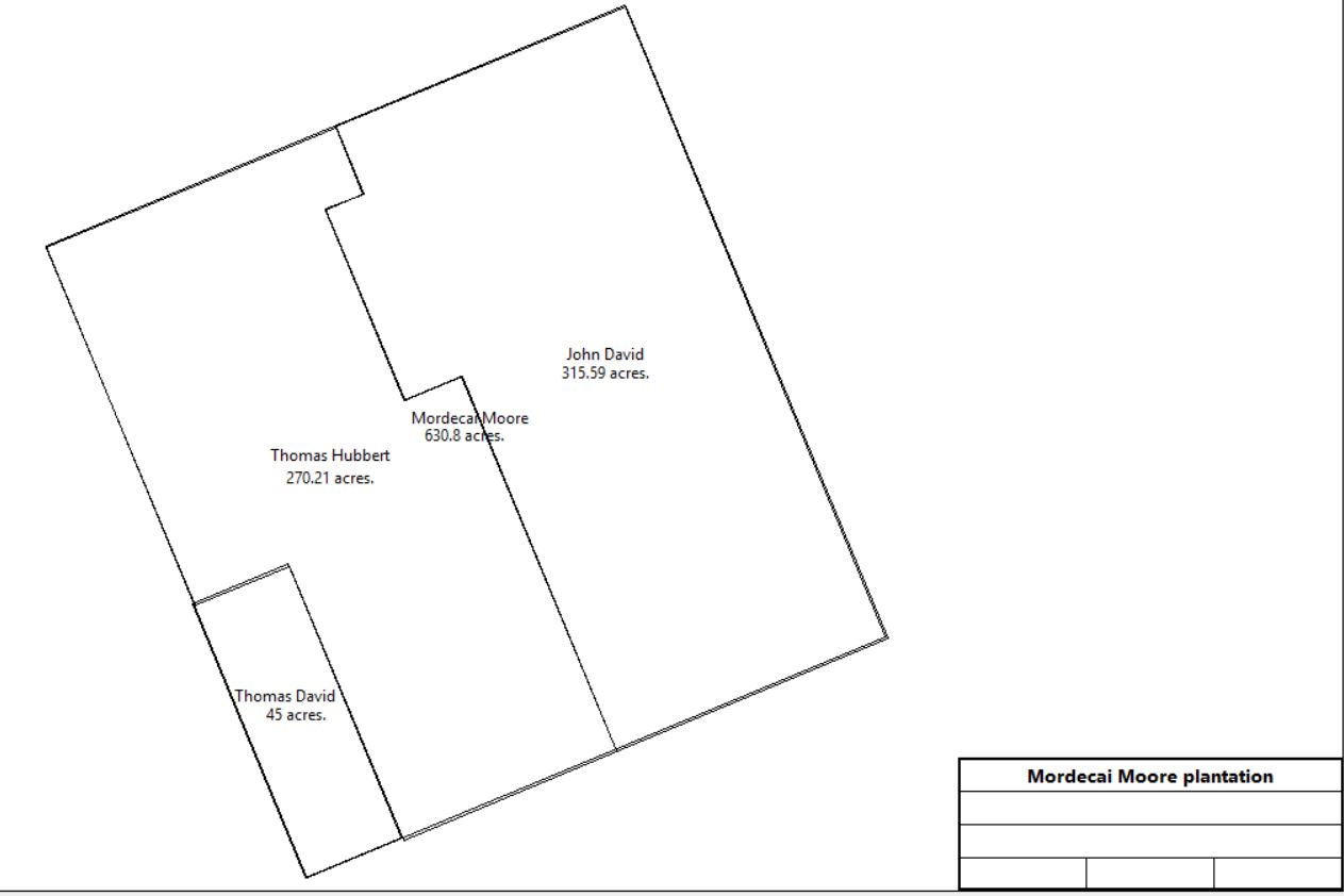
Mordecai Moore |
|
1688 |
500a |
|
Warrant dated 12/9/1688, Draft dated 12/12/1688; D-73-155/6; also see Taylor plan or below for redrawn plan |
Mordecai Moore |
|
1715 |
|
|
Tax; non-resident |
Mordecai Moore |
|
1718 |
|
|
Tax; non-resident |
Mordecai Moore |
|
1719 |
500a |
|
Tax; non-resident |
Mordecai Moore |
|
1720 |
500a |
|
Tax; non-resident |
Mordecai Moore |
|
1721 |
500a |
|
Tax; non-resident |
Mordecai Moore |
|
1722 |
500a |
|
Tax; non-resident |
Mordecai Moore |
|
1724 |
|
|
Tax; non-resident; last list of non-residents |
Mordecai Moore |
Richard Moore |
Before 1739 |
500a |
|
Will? Mentioned in Taylor Papers deed plan (reel 3) |
Richard Moore |
John David |
~ 1715 - 1730 |
315a |
|
East side of plot. See plan below. Deed not found. See table AN.1 |
Richard Moore |
Thomas Hubbert |
~ 1715 - 1730 |
265a |
|
See plan below. Deed not found.
See table AN.2. In 1715 tax |
Richard Moore |
Thomas David |
~ 1715 - 1730 |
50a by bounds |
|
SW corner of plot. See plan below. Deed not found. See table AN.3 |
|
|
|
Table AN.1 John David plantation
Table AN.1.1 Howellville Grist Mill & Woolen Factory
|
From |
To |
Date |
Area |
Cost |
Reference |
|
|
|
|
|
|
John David |
|
1748 |
|
|
Died |
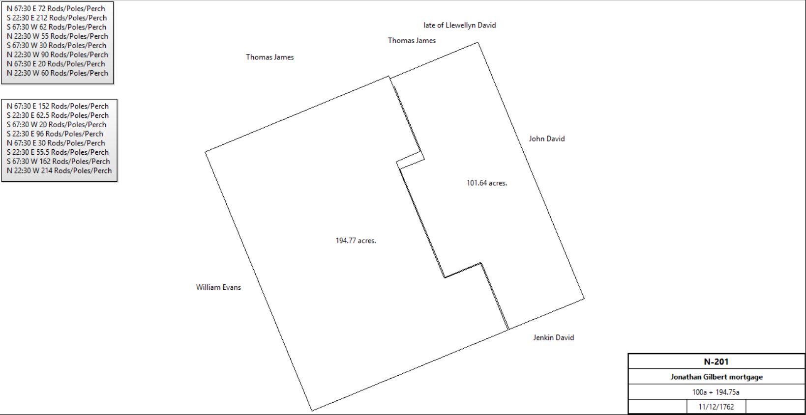
Jonathan Gilbert |
|
|
|
|
No purchase deed found |
Jonathan Gilbert |
|
1762 |
|
|
tax |
Jonathan Gilbert |
Trustees Coll. Of Phil. |
11/12/1763 |
194¾a & 100a adjoining on the east |
2,133 pieces of eight |
N-201 mortgage satisfied by Jacob Baugh 8/16/1796; Grist mill. See Baugh tract for further history of the larger tract. |
|
Jonathan Gilbert |
|
9/7/1764 |
100a & Grist Mill + 196a |
|
Inquisition. Neighbors (100a): Isaac Davis, Evan Davis, William Sharp & other land; (196a) John Wilson, Richard Evans, Michael Wayne |
Sheriff (John Fairlamb) |
Joshua Medinhall |
9/21/1764 |
100a |
|
Messuage, Corn mill; quoted in O-190 |
Joshua Medinhall |
Isaac Massey |
|
|
|
Ineffectually conveyed. |
Joshua & Lydia Medinhall, Isaac Massey |
David Howell & Samuel Weaver |
6/4/1765 |
100a |
|
Indenture of Release; quoted in O-190; deed not found. |
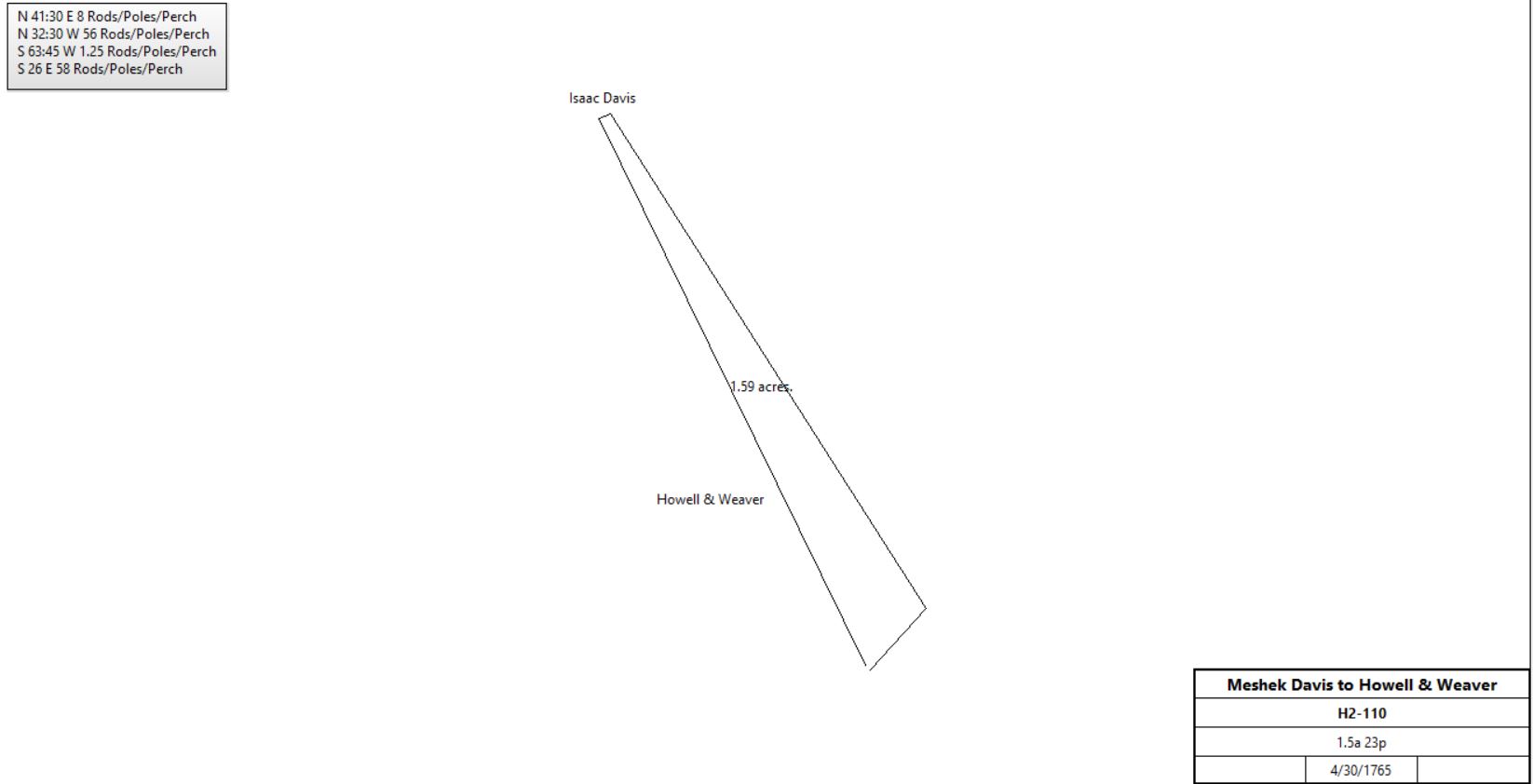
Meshech Davis |
David Howell & Samuel Weaver |
4/30/1765 |
1.5a 23p |
£20 10s |
H2-110; next to Mill dam; part of 500a bequeathed to grandson Meshech Davis |
|
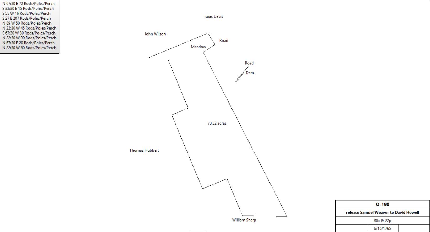
Samuel Weaver |
David & Mary Howell |
6/15/1765 |
80a + 22p |
15s |
O-190, release |
|
David & Mary Howell |
Samuel Weaver |
6/15/1765 |
19a, 4p, 12p, 1a 69p |
15s |
H2-106; same description as Q-456 |
Samuel Weaver |
|
1765 |
Grist Mill on 40a |
|
County tax |
Samuel Weaver |
|
1767 |
Grist Mill on 70a |
|
County tax |
Samuel & Mary Weaver |
Jacob Giradin |
4/25/1767 |
Mill & 4 lots: 19a, 4p, 12p, 1a 69p |
£418 |
Q-456 |
Samuel & Mary Weaver |
Jacob Giradin |
4/26/1767 |
154a (159?) 3 roods |
£223 13s + mortgage monies |
R-406; probably not relevant here, see table AH |
Jacob & Otillia Girardin |
Michael Cypher |
3/1/1771 |
Mill & 4 lots: 18¾a, 11½a, 4p, 12p |
£525 + £500 plus interest to College of Philadelphia |
W2-111 |
Jacob Cypher |
|
1775 |
Mill |
|
Provincial Tax |
Jacob Cypher |
|
1776 |
Mill |
|
Provincial Tax |
Michael Cypher |
|
9/1777 |
|
|
No depredation claim in 1782 |
Michael & Mary Cypher |
Casper Steinmetz |
12/10/1777 |
Mill & 4 lots: 18¾a, 11½a, 4p, 12p |
£950 |
W2-115 |
Casper Steinmetz |
|
1778 |
Mill |
|
State tax |
Casper Steinmetz |
|
1779 |
Mill |
|
tax |
Casper Steinmetz |
|
1781 |
Grist Mill & still |
|
tax |
Casper Steinmetz |
|
1783 |
Grist Mill & distillery |
|
tax |
Casper Steinmetz |
|
1785 |
Saw Mill |
|
State tax |
Casper Steinmetz |
|
1786 |
Grist Mill |
|
tax |
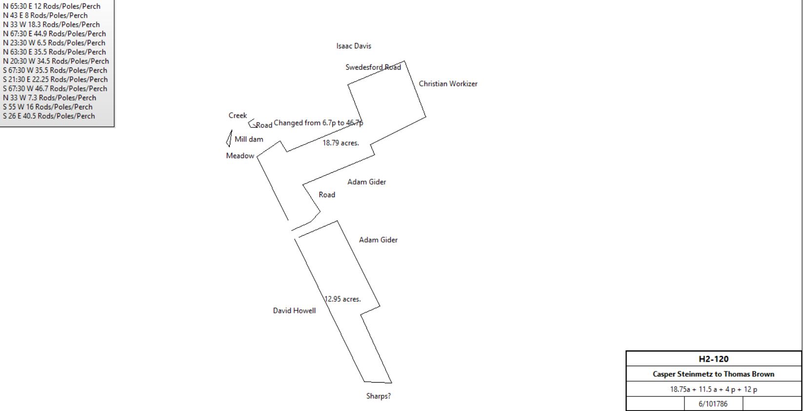
Casper & Catherine Steinmetz |
Thomas Brown |
6/10/1786 |
Mill & 4 lots 18¾a, 11½a, 4p, 12p |
£950 plus interest to College of Philadelphia |
H2-120 |
|
Thomas Brown |
Rees Price |
7/8/1791 |
Mill & 4 lots 18¾a, 11½a, 4p, 12p |
£750 |
H2-123 |
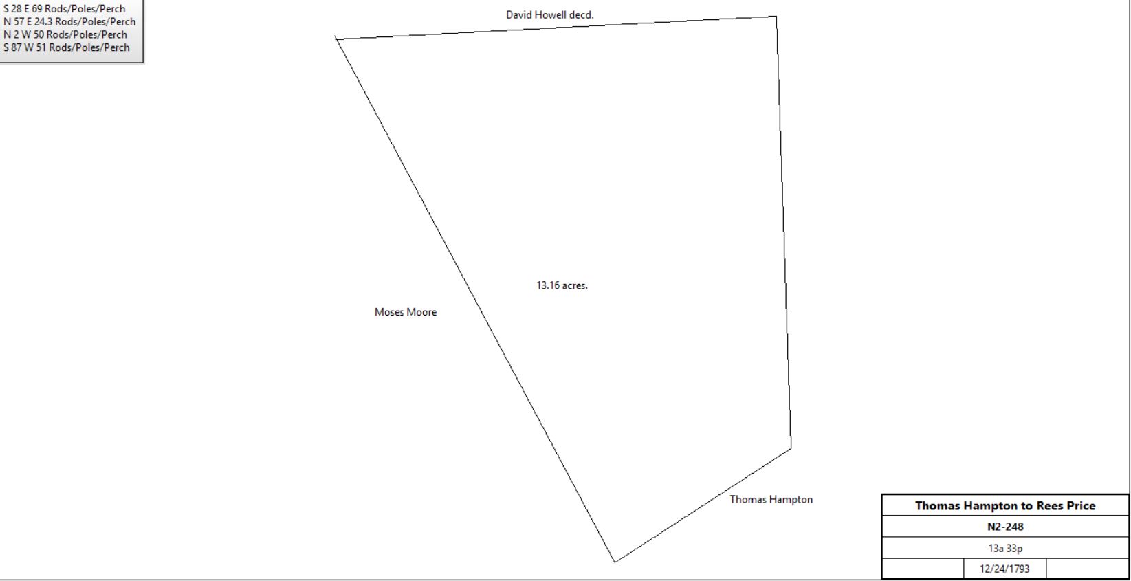
Thomas Hampton |
Rees Price |
12/24/1793 |
13a 33p |
£87 16s 5d |
N2-248; buildings, no messuage. See table AN.2.1 |
Rees Price |
|
1795 |
43a |
|
Tax, grist mill, tenant Jacob Keyser |
Rees & Hannah Price |
Adam Guider |
4/26/1796 |
Mill & 5 lots 18¾a, 11½a, 4p, 12p, 13a 33p |
£837 16s 5d |
O2-29; see deed plan for 5th tract See AN.3 for history of 5th plot. |
Abraham & Hannah Guider |
Jacob Benner of Northern Liberties, Philadelphia |
1/23/1798 |
Mill & 5 lots 18¾a, 11½a, 4p, 12p, 13a 33p |
£1200 |
Q2-311 |
Jacob Benner |
|
1798 |
44a; Stone Grist Mill 39’ x 36’; stone barn 40’ x 25’ |
|
Glass tax |
Jacob Benner |
Matthias Kolb |
3/31/1802 |
Corn or Grist Mill & 5 lots 18¾a, 11½a, 4p, 12p, 13a 33p |
£1500 |
X2-528 |
Matthias Kolb |
John Workizer |
3/16/1805 |
Corn or Grist Mill & 5 lots 18¾a, 11½a, 4p, 12p, 13a 33p |
$4266 66c |
Y2-276 |
John & Mary Workizer |
Abel Rees |
3/29/1806 |
5a 96p |
$255 |
H3-154 |
John & Mary Workizer |
Christian Fritz |
8/24/1808 |
12p |
$25 |
C3-358 |
John & Mary Workizer |
Peter Conway |
9/1/1810 |
#1: 18¾a, #2: 11½a, #3: 4p (mill dam), #4: 7a 127p |
$5,000 |
E3-246; grist mill. Tract #4 part of 13a 33p |
Peter Conway |
George Suckley |
6/26/1811 |
#1: 18¾a, #2: 11½a, #3: 4p (mill dam), #4: 7a 127p |
$5,000 |
F3-315; grist mill |
Sheriff |
Elizabeth Markley |
8/13/1818 |
12a & 21a |
|
Sheriff’s Deed vol. 2 p 120 – 121.. 2 tracts with improvements and mills,. Previous owners William & Sarah Baker |
Sheriff (Cromwell Pierce) |
James Hunt |
8/5/1819 |
#1: 18¾a, #2: 11½a, #3: 4p (mill dam), #4: 7a 127p |
|
Sheriff’s deed #2-157
Defendant Philip Snyder |
James & Anna Hunt |
Elizabeth Markly |
9/20/1819 |
Mill & 4 tracts: 18¾a, 11½a, 4p, 7a 127p |
$2010 |
P3-443 |
Exs of Elizabeth Markley |
|
1824 |
Stone mill, 3 stories on 40a, 2 pairs of stones |
|
Sale ad |
Executors of Elizabeth Markly |
Edward & Augustus Bartholomew |
4/1/1825 |
|
|
Y3-376; messuages, tenements, water corn or grist mill |
Public Sale 16th Dec. next 2 o’clock in the afternoon, a Valley farm, 40 acres of Valley land .. cultivated .. fences .. meadow and woodland, Tredyffrin Township, Chester Co., near Howell’s Tavern, bounded by lands of Wm. Hall, John Howell, late deceased .. about 18 miles from Philadelphia and 1 from the Lancaster Turnpike, excellent neighborhood, convenient .. improvements include dwelling and fine mill, 2 pair stone, overshot wheel, situate on the public road leading from Lancaster Turnpike to Swedesford .. stone barn, strong spring, orchard, garden, storehouse and dwelling house. Store kept at present. Edward Bartholomew, Augustine Bartholomew.
Village Record 11/15/1826 |
Edward, Augustus, & Mary Ann Bartholomew |
John Jones |
4/6/1827 |
#1: 18¾a, #2: 11½a #3: 4p (mill dam), #4: 7a 127p |
$3557 |
Z3-525 |
Edward, Augustus, & Mary Ann Bartholomew |
John Jones |
4/6/1827 |
11a 136p |
|
Z3-528 |
John Jones |
|
1827 |
Grist mill machinery |
|
Sale ad |
John Jones |
|
1827 |
Grist mill |
|
Sale ad |
John Jones |
|
1839 |
Fulling mill on 37a |
|
tax |
Robert Webster |
|
1842 |
|
|
Manufacturer of Woolen Goods at Howellville, carding (ad) |
Robert Webster |
|
1844 |
|
|
Manufacturer of Woolen Goods at Howellville, carding (ad) |
Robert Webster |
|
1845 |
|
|
Manufacturer of Woolen Goods at Howellville, carding (ad) |
Robert Webster |
|
1847 |
|
|
Manufacturer of Woolen Goods at Howellville, carding (ad) |
Robert Webster |
|
1848 |
|
|
Manufacturer of Woolen Goods at Howellville, (newspaper clipping) |
John E. Webster |
|
1848 |
|
|
Manufacturer of Woolen Goods at Howellville, carding (ad) |
Robert Webster |
|
1850 |
|
|
Kentucky Geans, 216 spindles, 10 looms, 9 people employed (manufacturing census) |
Robert Webster |
|
1851 |
|
|
Destroyed by fire (owned by John Jones) |
John & Elizabeth Jones |
Samuel Wood jr. |
4/5/1860 |
4a 16p |
$6250 |
N6-444 |
John & Elizabeth Jones |
Joseph Eavasen |
12/12/1861 |
8a 88p |
$475 |
S6-309; see table AN.1.1.2 |
John & Elizabeth Jones |
Daniel Stetson |
4/10/1867 |
15a 53p & 145p |
$6200 |
D7-490; 2 tenements; see table AN.1.1.1 |
John & Elizabeth Jones |
Samuel Wood jr. |
4/19/1867 |
1.1p |
$20 |
Z7-230 |
|
|
1870 |
|
|
Cotton & Wool factory idled, 35 unemployed (newspaper clipping) |
Estate of Samuel Wood sr. |
Samuel Wood jr. |
11/20/1873 |
|
|
Bankruptcy |
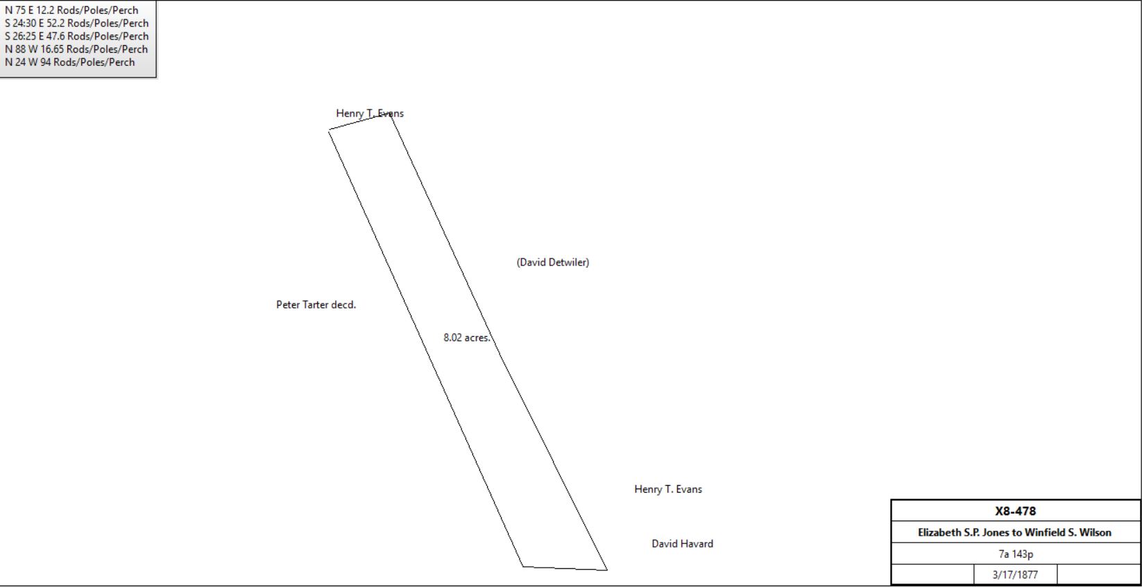
Elizabeth Jones et al (part of estate of John Jones) |
Winfield S. Wilson |
3/17/1877 |
7a 143p |
$592 60c |
X8-478 (part of Z3-528) |
|
Samuel Wood |
|
1879 |
|
|
Idle for 2.5 years (newspaper clipping) |
Samuel Wood |
|
1879 |
|
|
Closed for new boiler (newspaper clipping) |
Sheriff (James McFarlan) |
Isaac W. Smith |
1/27/1880 |
4a 16p |
$100 |
Sheriff’s deed #8-350
Description as N6-444 |
Samuel Wood |
|
1880 |
|
|
Woolen mills in operation again, making woolen yarn, rather than shoddy, 1 dozen employees (newspaper clipping) |
Samuel Wood |
|
1880 |
|
|
Adding 400 new spindles (newspaper clipping) |
Samuel Wood |
|
1881 |
|
|
Mill going back into operation (newspaper clipping) |
Mrs. Samuel Wood |
|
1882 |
|
|
Samuel Wood jr., operator, mill destroyed by fire, 3 stories (newspaper clipping) |
Mrs. Eliza Evans |
|
1873 |
|
|
Witmer’s Atlas |
Mrs. E. Evans |
|
1883 |
53a |
|
Breou’s Atlas |
Mrs. Eliza Evans |
|
1883 |
46a |
|
Tredyffrin tax return |
|
|
|
|
|
|
James Reilly |
|
1883 |
130a |
|
Breou’s Atlas |
James Reilly / Riley |
|
1883 |
|
|
not in Tredyffrin taxes |
James Reilly, merchant |
|
1884 |
83a + 14a (from C. Killny) |
|
tax return |
James Reilly, merchant |
|
1888 |
97a |
|
tax return |
William Gallagher, sheriff, debt of James Reilly |
Edward Evans |
11/1/1888 |
88a 105p |
$10,000 |
Sheriff’s deed 9-462 |
Edward Evans |
|
1889 |
82a at Howellville |
|
tax return |
Edward & Mildred Evans |
John Dyer |
8/5/1890 |
88a 105p |
$14,000 |
R10-378 |
John & Mary Dyer |
John C. Wilson |
9/14/1891 |
88a 105p + 15a - exceptions (not completely specified) |
$36,000 |
X10-442 |
John C. Wilson |
Pennsylvania Railroad |
11/12/1891 |
23.327a |
$1 |
X10-445 |
John C. Wilson |
John Dyer |
11/12/1891 |
26.931a |
$23,000 |
X10-447 |
|
Q-456 #1 Beginning at a post near the line of other land of David Howell and Weaver, thence S55°W 13p to a post in the meadow, thence S27°E 207p to a post for a corner in the line of William Sharp’s land, thence S87°E 15p by Sharp’s land to a stone being a corner, thence N27°W 216p to the place of beginning. Containing 19a
#2: Beginning at a poplar tree by the mill dam, thence N40°W 3p to a walnut tree, thence N24°E 8p to a post in the west end of the mill dam, thence by the side of the mill dam several courses to the place of beginning. Containing 4p.
#3: Beginning at a post by the road the west side of the creek or run of water, thence S55°W 4p to a walnut tree, thence S27°E 3p to a post, thence S87°E 4p to a post by the road, thence N55°E by the road 3p to the place of beginning. Containing 12p
#4 Beginning at a stone at the south end of the mill dam or mill pond next to the road, thence N41½°E 8p to a black oak saplin standing by the road, thence N32½°W 41p by said road to a post for a corner, thence S55°W 3p to a post in the line of the above mentioned land of Howell and Weaver, thence S26°E by last mentioned land 42p to the place of beginning. 1a 69p
W2-111 #1: Beginning at a post near an apple tree, thence N65½°E 12p to a stone, thence N43°E 8p to a dead black oak, thence N33°W 8.3p to a stone, thence N67½°E 44.9p to a post, thence N23½°W 6½p to a post, all by land of Adam Gider, thence N24½°W to a hickory tree standing on Swedesford Road, thence by the same and land of Isaac Davis WSW 35½p to a post, thence S21½°E 22¼p to a post, thence S67½°W 46.7p to a post, thence N33°W 7.3p to a post, thence S55°W 16p to a post in the meadow, thence S26°W 40.5p to the place of beginning. Containing 18¾a
#2: Beginning at a post in the line of David Howell’s land, thence by land of Adam Gider N66½°E 24p to a post, thence by the same land S26½°E 55p to a heap of stones, thence by same land S66½°W 12p to a gum saplin, thence by same land S25½°E 43.3p to a stone in the line of Sharp’s land, thence by the same N88°W 16p to a post, thence by land of David Howell N26°W 91.4p to the place of beginning. Containing 11½a.
#3: Beginning at a poplar tree by the mill dam, thence N40°W 3p to a walnut tree, thence N24°E 8p to a post in the west end of the mill dam, thence by the side of the mill dam several courses to the place of beginning. Containing 4p.
#4: Beginning at a post by the road the west side of the creek or run of water, thence S55°W 4p to a walnut tree, thence S27°E 3p to a post, thence S87°E 4p to a post by the road, thence N55°E by the road 3p to the place of beginning. Containing 12p
W2-115 Same recitation as W2-111, except #1 mentions land of Christian Workizer by Swedesford Road.
Z3-525 Messuage, grist mill and 3 lots in Tredyffrin, #1 on which grist mill is erected. Beginning at stone near apple tree, N65½°E 12p to a stone, N43°E 8p to a black oak, N33°W 8¼p to stone, N67½°E 44.9p to post, N23¼°W 6 to post, N63¼°W 30½p to stone, thence by Adam Gider, N28½°W by Christian Workizer 34½p and by Swedesford Road, thence by John Daniels WSW 35½p to post, and S21½°E 22¼p to post and S67½°W 46.7p and N33°W 7.3p and S55°W 16p to post, in meadow thence by John Howell S26°W40½p to place of beginning. Containing 18¾a, #2: 11½a, #3: 4p (mill dam), #4: 7a 127p. Same description as Y3-376
V6(? 135)-444 Messuage, mill or factory and tract of land in Tredyffrin beginning at stone in public road a corner of other land of Jones, thence along same between mill and the store W 3.47p to stone S20½°W 5.1p to stone, S2°W 4.7p to willow, S15½°E 5.22p running near west side of spring house, to stone, thence still along same S43½°W 1.27p to post in line of John Coates estate, thence by same S25½°E 26.47p to post, N70¾°E 9.7p and N41½°E 13.25p to stone in said public road, and in line of other land of Jones, thence same by said road N36¾°W 25.3p to stone, thence by Jones N51½°E 3.45p and N21½°W 6.47p to stake in line of John Coates estate, thence by same and other land of Jones S68½°W 3.55p to post, and S52¾°W 3.9p to stone in said public road, and along same N65¼°W 4.18p to place of beginning.
Part of Z3-525 Excepting and reserving the right to divert the water from race or water passage by connecting a leaden or other kind of pipe ¾ of an inch in diameter in the inside of the forebay for the purpose of supplying two dwelling houses with water. (also right of access for repair).
Z7-230 Beginning at stone in public road leading from Howellville to Reeseville, and at a corner of Samuel Wood jr., thence along said land N52¾°E 3.9p to corner of Henry S. Evans, thence along same N31½°W 0.9p to corner of Daniel Stetson, thence along same S50°W 5.37p to place of beginning.
|
Table AN.1.1.1 – Howellville Store & Post Office
|
From |
To |
Date |
Area |
Cost |
Reference |
|
|
|
|
|
|
John & Elizabeth Jones |
Daniel Stetson |
4/10/1867 |
15a 53p & 145p |
$6200 |
D7-490; 2 tenements; see above for earlier history |
Sheriff (debt of Daniel Stetson) |
Hugh Steen |
8/17/1871 |
16a 38p |
$7100 |
Sheriff’s deed vol. 7, page 103 |
Hugh Steen |
Annie S. Beitler |
6/4/1877 |
16a 38p |
$12,000 |
X8-335 |
John Beitler |
|
1883 |
|
|
Breou’s Atlas |
John & Annie Beitler |
Hugh Steen |
3/16/1894 |
|
$8000 |
D11-446 |
Hugh J. Steen |
|
1897 |
|
|
Mueller’s Atlas |
Hugh Steen |
Annie Bietler, daughter |
1899 |
|
|
Bequest; store & 4 houses |
Hugh J. Steen |
|
1912 |
16a |
|
Mueller’s Atlas |
Annie & John Beitler |
Angelo Meoli |
1/3/1920 |
16a 38p |
$8000 |
O15-491; messuages, store property |
A. Meali |
|
1933 |
45a |
|
Franklin’s Atlas |
|
Table AN.1.1.2
|
From |
To |
Date |
Area |
Cost |
Reference |
|
|
|
|
|
|
John & Elizabeth Jones |
Joseph Eavasen |
12/12/1861 |
8a 88p |
$475 |
S6-309; see above for earlier history |
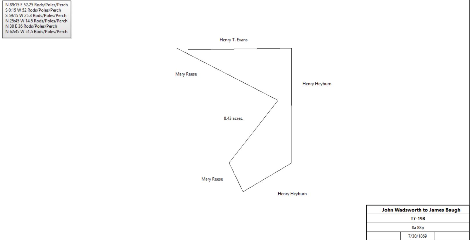
Joseph & Sophia Eavenson |
John Wadsworth |
3/31/1864 |
|
|
not found, quoted in T7-198 |
John & Emeline Wadsworth |
James C. Baugh |
7/30/1869 |
8a 88p |
$250 |
T7-198 |
|
|
Table AN.1.2 – Howellville Tavern tract & later quarry
|
From |
To |
Date |
Area |
Cost |
Reference |
|
|
|
|
|
|
Joseph Mitchell |
|
1745 |
|
|
|
|
|
1745 |
|
|
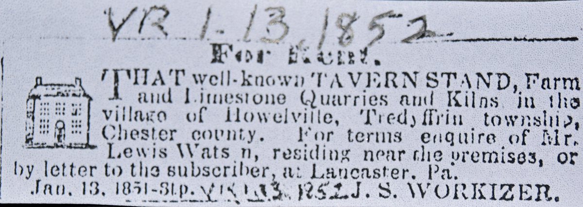
First license (Howellville by Sue Andrews) |
Jonathan Gilbert |
Trustees Coll. Of Phil. |
11/12/1763 |
194¾a & 100a adjoining on the east |
|
N-201 mortgage satisfied by Jacob Baugh 8/16/1796; see deed plan |
Samuel Weaver |
David Howell, inn keeper |
6/15/1765 |
80a & 22p |
|
O-190 |
|
Alexander & Abigail Colley |
David Howell |
11/10/1766 |
63a |
|
Not recorded but cited in Z3-269; from table AH |
David Howell |
|
1766 |
|
|
Tavern mentioned in advert |
David Howell |
|
1767 |
150a |
|
Tax. |
David Howell |
|
1768- 1778 |
|
|
Landlord |
|
|
9/1777 |
|
|
British General Gray quartered in the Inn |
David Howell |
|
1778 |
140a |
|
Tax. |
David Howell |
Children: John, Samuel, Rees, Anne (Stonemetz) & Mary Howell |
4/1/1778 (Will) |
150a 22p |
|
Died; probate 5/27/1780 Will book #6, 445 |
Mary Howell |
|
1779 |
100a |
|
Tax. Innkeeper |
Mary Howell |
|
1781 |
100a |
|
Tax. Tavern |
Mary Howell |
|
1783 |
108a or 118a |
|
Tax. Innholder |
John Howell |
|
1785 |
|
|
Tax. Freeman |
John Howil |
|
1786 |
|
|
Tax. Freeman |
John Howell |
|
1788 |
|
|
Tax. Freeman |
John Howell |
|
1791 |
129a |
|
Tax. Tavern |
Samuel Howell |
John Howell |
5/6/1791 |
1/5 interest |
|
Release S2-516 |
Anne & Casper Stonemetz |
John Russel |
2/23/1792 |
1/5 interest |
£200 |
Assignment G2-180 |
John Russel |
John Howell |
5/19/1792 |
1/5 interest |
|
Assignment G2-190 |
Rees Howell |
John Howell |
6/15/1795 |
1/5 interest |
|
Release S2-517 |
John Howell |
|
1795 |
150a |
|
Tax. Tenant Rees Howell |
Rees Howell |
|
1797 |
150a |
|
Tax. Innkeeper |
Rees Howell |
|
1798 |
150a |
|
Tax. Innkeeper |
John Howell |
|
1798 |
147a |
|
Glass tax; tenant William Webb |
John Howell |
|
1799 |
150a |
|
Tax. Innkeeper |
Mary Howell |
John Howell |
10/15/1800 |
1/5 interest |
|
Unrecorded deed |
John Howell |
|
1/30/1806 |
|
|
(Will) |
Devault Beaver, executor of John Howell |
Samuel Howell |
12/4/1826 |
80a, 22p, 63a, 7a |
$6890 |
Z3-269 |
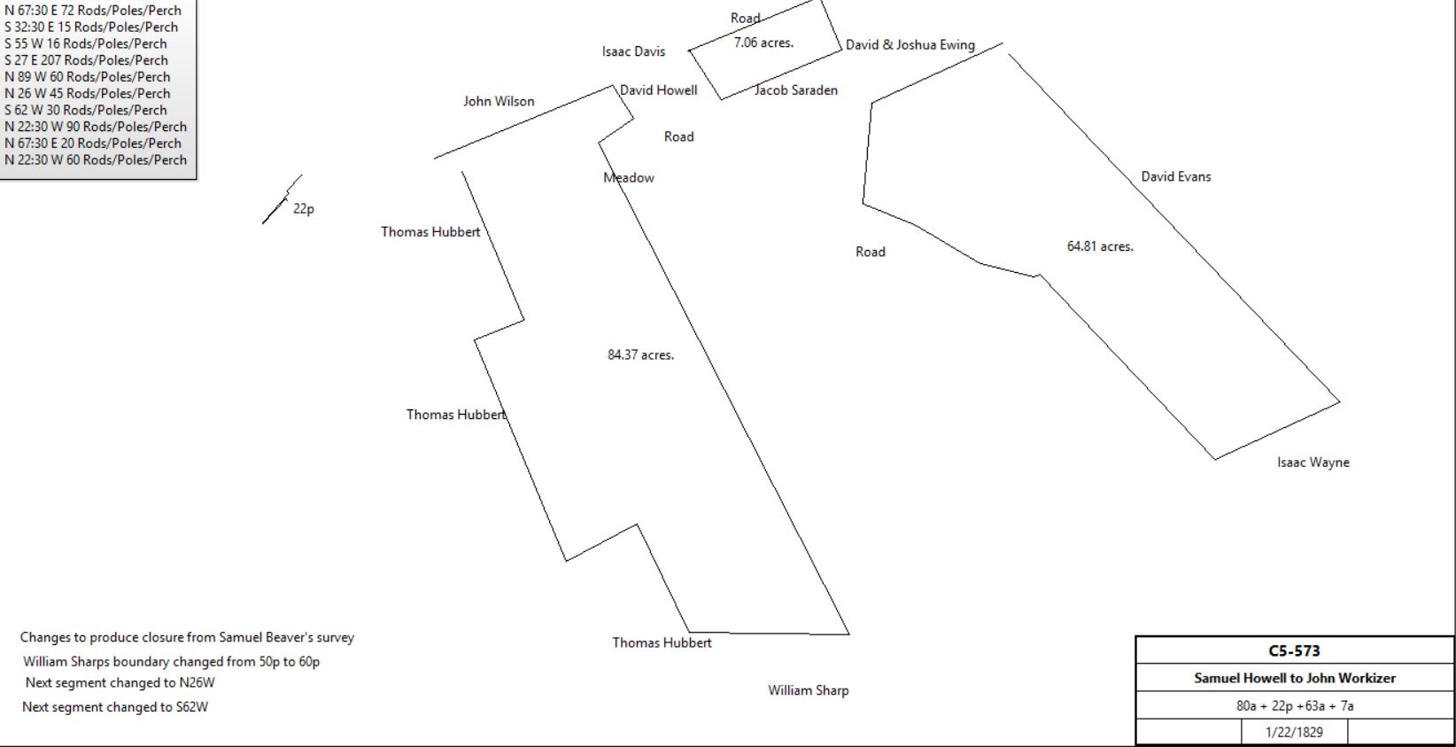
John & Hannah Howell |
John Workizer |
1/22/1829 |
80a, 22p, 63a, 7a |
$6,720 |
C5-573; see Samuel Beaver’s survey |
|
Horatio J. & Elizabeth Supplee |
Washington Garner |
3/20/1840 |
13a, part of 80a 109p |
$1,950 |
S4-688; includes taverns |
Washington & Hannah Garner |
Charles Thompson |
7/17/1847 |
13a |
$2,600 |
D5-598 |
|
|
Charles & Margaret Thompson |
Henry J. Evans |
3/29/1855 |
15a |
$7,000 |
Y5-115 |
John S. & Ann H. Workizer |
Jacob Morton Albertson |
3/31/1856 |
88a 105p |
$13,200 |
C6-255; water rights to Henry Munshower’s land from spring. |
Jacob Morton Albertson |
Samuel S. Albertson |
3/31/1856 |
88a 105p |
$13,300 |
C6-257; messuage, tavern house, & plantation |
Samuel S. Albertson |
John Coats |
4/3/1857 |
88a 105p |
$15,000 & dower deed |
T6-514; Howellville tavern property |
John & Serepta Coates |
Henry J. Evans |
3/9/1866 |
88a 105p |
$12,525 |
D7-73 |
Excrs. of Henry J. Evans |
Christian F. Kelling |
4/1/1871 |
15a |
|
X7-580 |
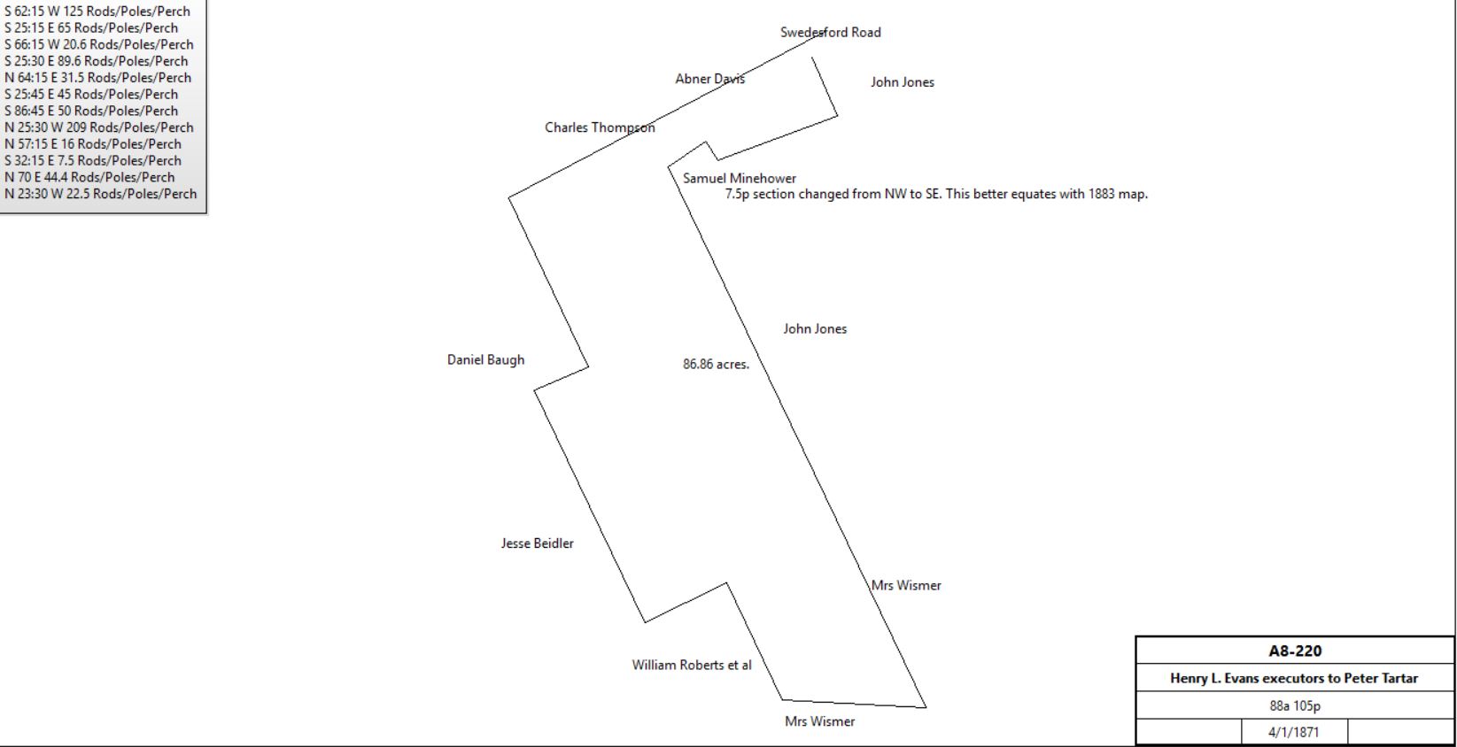
Excrs. of Henry J. Evans |
Peter Tartar |
4/1/1871 |
88a 105p |
$13,001 |
A8-220 – same as C6-255 |
|
|
|
1872 |
|
|
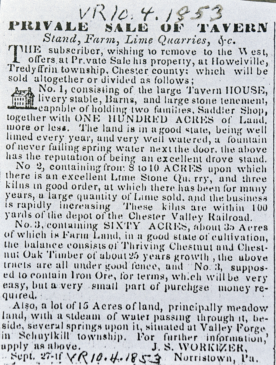
Hugh Steen, tavern keeper; Sue Andrews Howellville |
Excrs. of Peter Tarter |
Joseph Dewees |
4/9/1877 |
88a 105p |
$12,200 |
X8-140 |
Excrs. of Joseph Dewees |
James Riley |
4/3/1883 |
88a 105p |
$13,100 |
S9-38; same description as C6-255. messuage & plantation |
Christian Kelling |
James Riley |
4/9/1883 |
15a |
$14,000 |
T9-120; messuage & tract |
James Riley |
|
1883 |
103a |
|
Breou’s Atlas |
|
|
|
|
|
|
Christian & Susan Kolling |
James Reilly |
4/9/1883 |
15a |
$14,000 |
T9-120 |
William Gallagher, sheriff |
Charles Sim |
11/1/1888 |
15a |
$7,216 |
Sheriff’s deed 9-474 |
Charles & Margaret Sim |
John Kinnear |
8/1/1889 |
½ part of 15a |
$3,608 |
O10-261 |
Charles & Margaret Sim & John Kinnear |
John Dyer |
3/19/1890 |
15a |
$22,000 |
R10-134 |
|
Table AN.2 Thomas Hubbert plantation
|
From |
To |
Date |
Area |
Cost |
Reference |
|
|
|
|
|
|
Barnard Vanleer |
Mary Moore during her natural life. |
Died 1/13/1790 |
100a purchased from Conrad Young and 80a from Thomas Hubbert |
|
Will dated 2/10/1786
Thomas Hubbert sale not recorded in Chester County Archives
See Table L |
|
Table AN.2.1 - Hampton tract
|
From |
To |
Date |
Area |
Cost |
Reference |
|
|
|
|
|
|
William Shank |
heirs |
|
|
|
Not in tax record |
Whitehead Wetherby |
|
1765 |
|
|
Tax - singleman |
Whitehead Wetherby |
|
1767 |
|
|
Tax – singleman with 100a |
David & Margaret Peasley |
Whitehead Wetherby |
2/13/1772 |
|
|
Unrecorded deed |
Whitehead Wetherby |
Thomas Hampton |
2/20/1772 |
|
|
Unrecorded deed |
Mary Shank |
Thomas Hampton |
2/20/1772 |
|
|
Unrecorded deed |
Benjamin & Mary Duncan |
Thomas Hampton |
4/4/1772 |
|
|
Unrecorded deed |
Whitehead Wetherby |
|
1774 |
|
|
Not in tax list (but sons? are listed) |
Thomas Hampton |
|
1774 |
92a |
|
Tax |
Thomas Hampton |
|
1778 |
70a & buildings |
|
Tax |
Thomas Hampton |
|
1779 |
100a |
|
Tax |
Thomas Hampton |
|
1781 |
80a |
|
Tax |
Thomas Hampton |
|
1783 |
100a |
|
Tax |
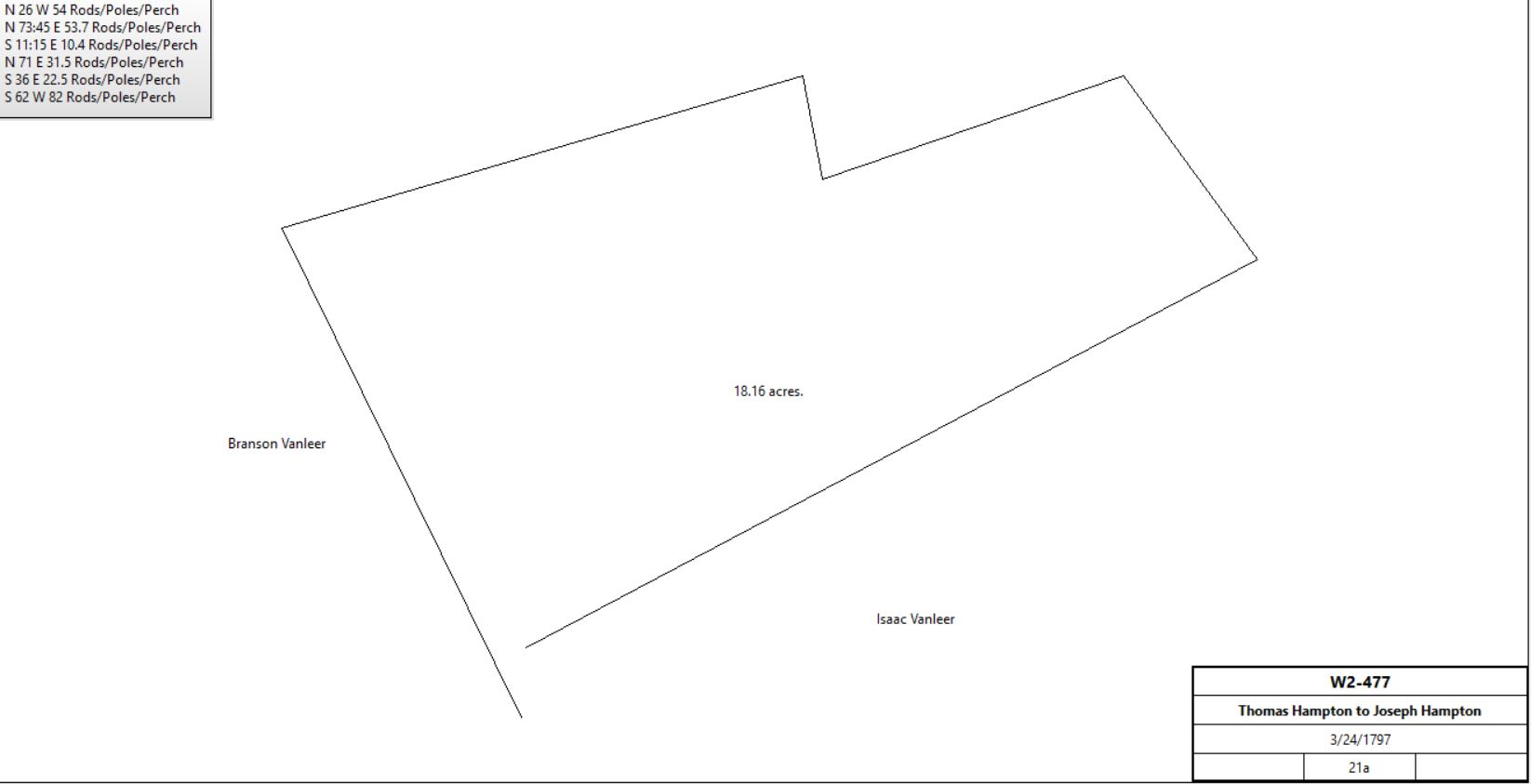
Thomas & Mary Hampton |
Joseph Hampton |
3/24/1797 |
21a |
£25 |
W2-477 |
|
Joseph Hampton |
|
1785 |
45a |
|
Tax |
Thomas Hampton |
|
1789 |
100a |
|
Tax |
Thomas Hampton |
|
1791 |
100a |
|
Tax |
Thomas Hampton |
|
1795 |
65a |
|
Tax |
Joseph Hampton |
|
1795 |
20a |
|
Tax; weaver |
Thomas Hampton |
Rees Price |
12/24/1793 |
13a 33p |
£87 16s 5d |
N2-248; buildings, no messuage. See table AN.1.1 for sale |
|
Thomas Hampton |
Benjamin Vodges |
? |
2a 20p |
|
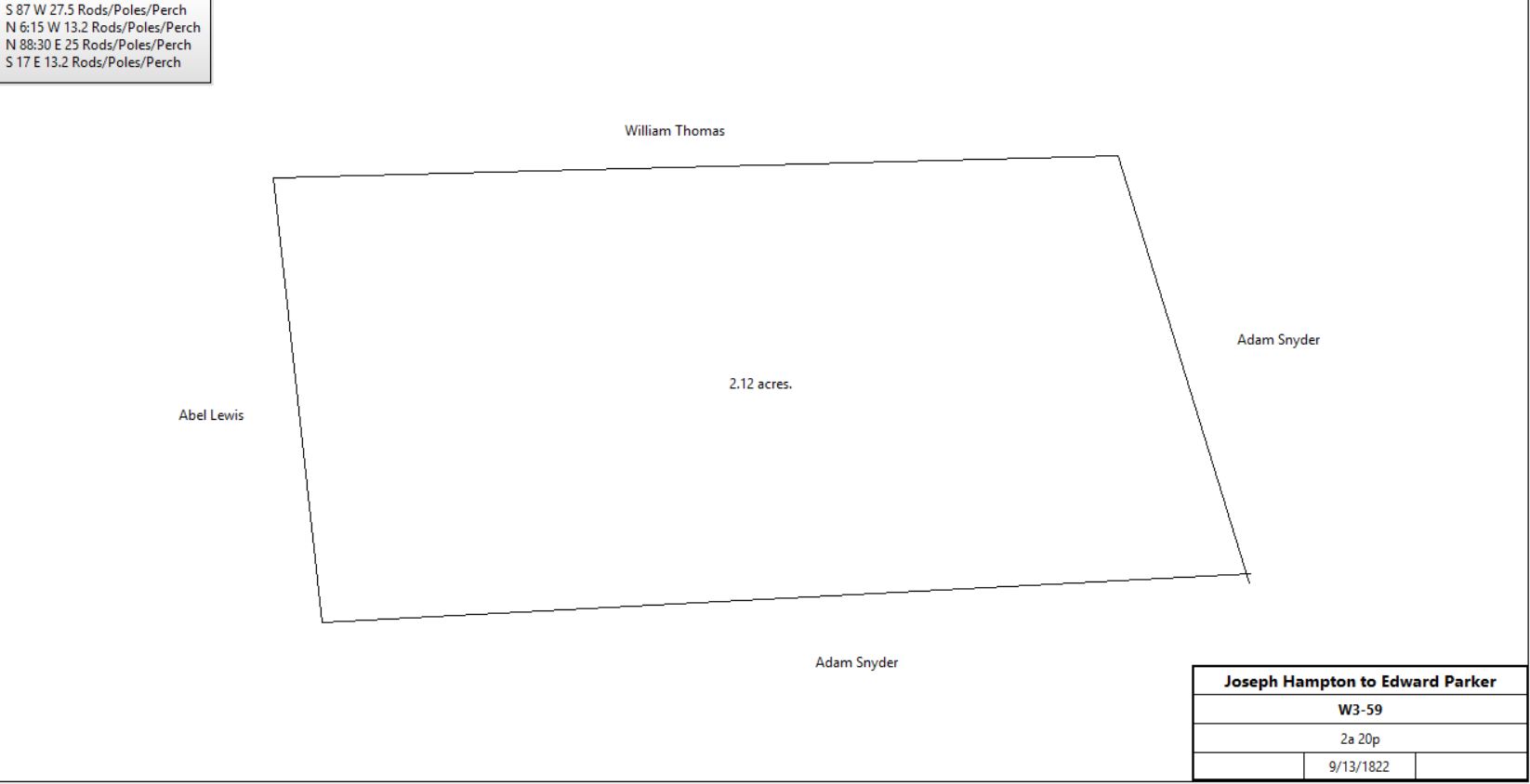
Deed not found; quoted in W3-59; see table AN.2.1.2 |
Thomas Hampton |
|
1797 |
65a |
|
Tax, shoemaker |
Joseph Hampton |
|
1798 |
20a |
|
Tax; weaver |
Thomas Hampton |
|
1798 |
65a |
|
Tax, shoemaker |
Joseph Hampton |
|
1798 |
20a |
|
Tax; weaver |
Joseph Hampton |
|
1798 |
20a |
|
22’ x 20’ Log Cabin (1 floor) Glass tax |
Thomas Hampton |
|
1798 |
65a |
|
24’ x 20’ Log Cabin (2 floors) Glass tax |
Thomas Hampton |
|
1799 |
65a |
|
Tax |
Joseph Hampton |
|
1799 |
21a |
|
Tax |
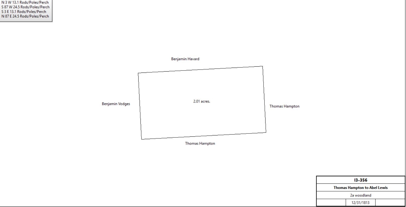
Thomas Hampton |
Abel Lewis |
31/12/1813 |
2a |
$200 |
I3-356; messuage? |
|
Thomas Hampton |
Adam Snyder |
6/26/1815 |
(13a 130p) |
$5 |
N3-85; agreement |
Benjamin Hampton |
George Norman |
8/25/1815 |
~60a (part interest?) Bounded by lands of William Vanleer, Joseph Hampton, William Thomas and others |
$175 |
N3-35; release of Tredyffrin lands of Thomas Hampton, deceased,, in possession of Mary Pennington (previously Hampton) |
Joseph Hampton (for heirs of Thomas Hampton) |
Israel Massey |
5/3/1817 |
50a 32p |
$2,873 95c |
O3-274 |
Israel & Rachel Massey |
Joseph Hampton |
5/3/1817 |
50a 32p |
|
O3-276; see deed plan |
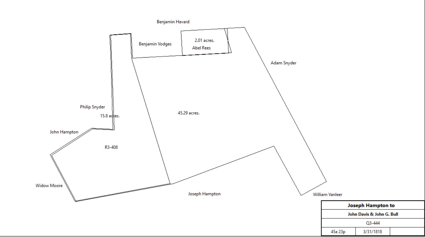
Joseph & Susanna Hampton |
John David & John G. Bull |
3/31/1818 |
45a 23p |
$2821 48c |
Q3-444; see Branch B below for continuation |
|
John David & John G. Bull |
Adam Snyder |
2/15/1819 |
14a 6p |
|
Not found. Quoted in Z9-446 & F6-63. See table Z.5 |
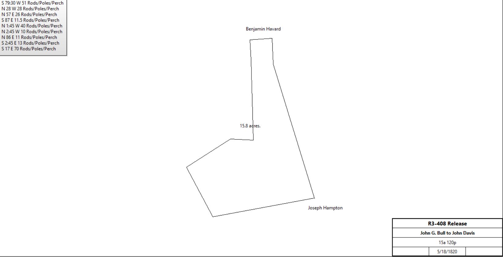
John G. Bull |
John Davis |
5/18/1820 |
15a 101p |
$10 |
R3-408 Release |
|
John & Joanna Davis |
Thomas Courson |
3/10/1821 |
5a 2p, part of 15a |
$350 |
U3-44 |
Mary, Ann, Benjamin & Charles Davis, Heirs of John Davis |
John M. David |
4/6/1829 |
10a 99p, part of 15a |
$350 |
V4-161 |
|
Adam Snyder |
|
9/22/1837 |
|
|
Will proved 12/30/1837 |
|
|
|
|
|
|
Branch A |
Thomas Hampton, administrator of the estate of Joseph Hampton |
Jacob & Daniel Kitselman |
5/7/1838 |
26a 2r 26p |
$1,013 17.5c |
P4-481 |
Jacob & Susanna Kitselman |
James Kithcart |
3/6/1840 |
26a 2r 26p |
$1,600 |
S4-552 |
James & Margaret Kithcart |
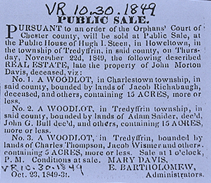
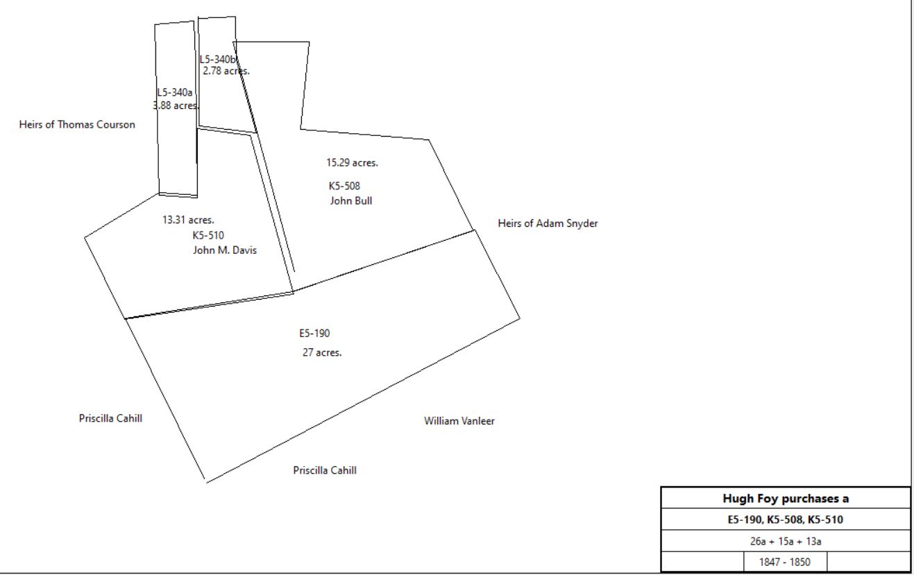
Hugh Foy |
1/16/1847 |
26a 2r 26p |
$1,600 |
E5-190 |
|
Branch B |
Joseph & Susanna Hampton |
John David & John G. Bull |
3/31/1818 |
45a 23p |
$2821 48c |
Q3-444; see above |
John & Joanna Davis |
John G. Bull |
|
|
|
Release, not found |
John Elliot, Lewis G. Bull & William Henry, executors of the will of John G. Bull |
Hugh Foy |
4/1/1850 |
15a 76p |
$541 84c |
K5-508 |
Branch C |
Mary, Ann, Benjamin & Charles Davis, Heirs of John Davis |
John M. David |
4/6/1829 |
10a 99p, part of 15a |
$350 |
V4-161; see above for earlier history |
Charles (Inn Keeper) & Margaret Thompson |
John M. Davis |
6/12/1840 |
5a 2p |
$225 |
V4-166 |
Mary Davis & Edward Batholomew, administrators of the estate of John Morton Davis |
Hugh Foy |
4/2/1850 |
13a 1r 7p |
$598 21c |
K5-510 |
Branch D |
Joseph, Taylor, sheriff |
Jacob Wismer |
2/6/1840 |
3a 3r 11p |
|
Sheriff's deed 4-251 |
John M. Davis |
Jacob Wismer |
4/27/1841 |
2a 135p |
|
I5-574 |
Jacob & Mary Wismer |
Hugh Foy |
4/29/1850 |
3a 3r 11p + 2a 135p |
$450 |
L5-340 |
Branch E |
Exs. Of Alexander Guider |
John G. Bull |
1808 |
111a 71p |
$4831 |
B3-204; see Table AH |
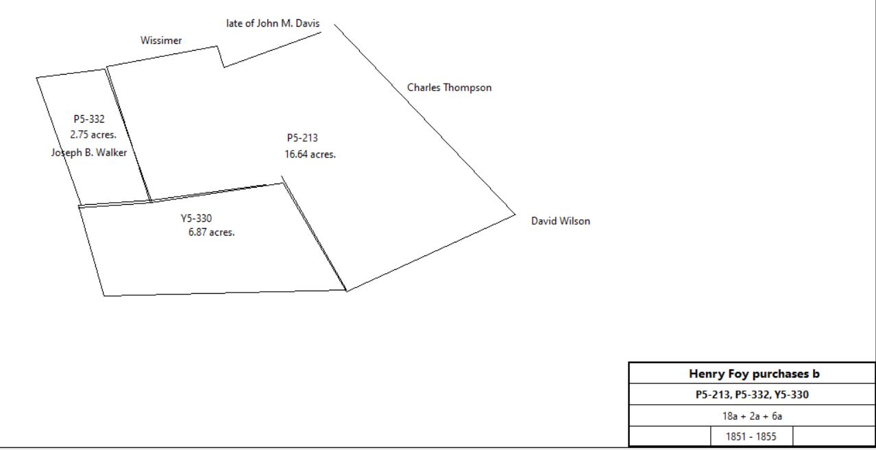
John Elliot, Lewis G. Bull & William Henry, executors of the will of John G. Bull |
Hugh Foy |
4/26/1851 |
18a 1r 12p |
$467 |
P5-213 |
Branch F |
Mary Thomas, William Thomas |
Joseph B. Walker |
3/13/1835 |
8a 3r 10p |
$140 |
P4-373 |
Margaret Thomas |
Joseph B. Walker |
3/13/1835 |
|
$1 |
P4-375; release of right of dower |
Joseph B. & Hannah Walker |
Hugh Foy |
11/17/1851 |
2a 130p |
$30 |
P5-332 |
Joseph B. & Hannah Walker |
Hugh Foy |
4/4/1855 |
6a 120p |
$405 |
Y5-330 |
|
|
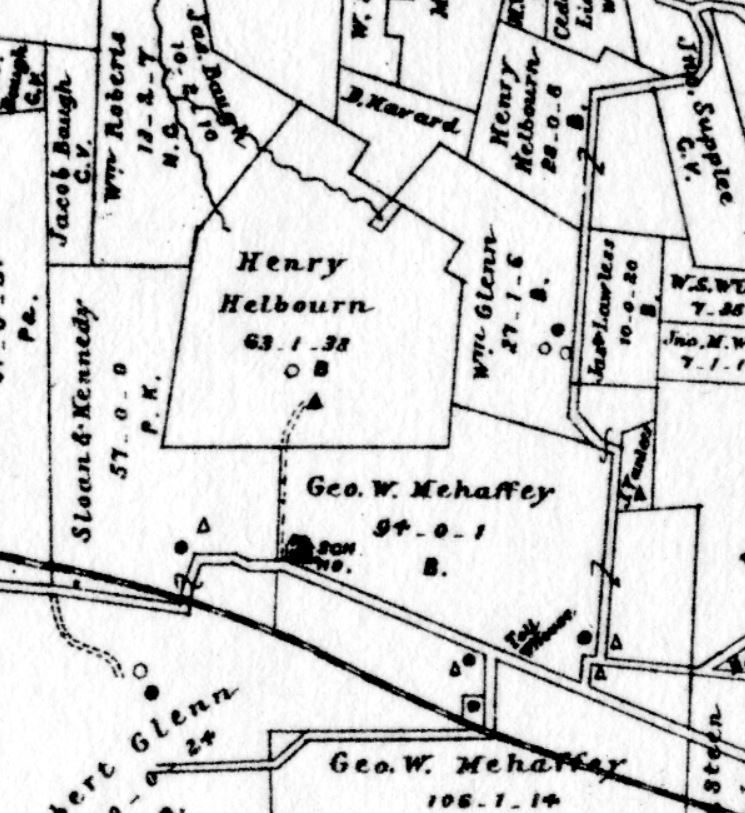
Bernard Foy, administrator of the estate of Hugh Foy |
Henry Hebourn |
3/31/1869 |
63a 73.75p + 28a 8.5p |
$6,406 |
P7-549 |
Henry Helbourne (Heyburn) |
|
1883 |
63a |
|
1883 atlas |
|
Henry Heyburn |
|
1887 |
|
|
1887 atlas |
Henry Heyburn estate |
|
1897 |
|
|
Atlas |
Henry Heyburn estate |
|
1900 |
59a |
|
Atlas |
Henry Heyburn estate |
|
1908 |
59a |
|
Atlas |
Henry Heyburn estate |
|
1912 |
59a |
|
Atlas |
Matilda Heyburn et al, executors |
Mrs Katherine Trump |
1913 |
|
|
L14-151 |
Mrs Catherine Trump |
|
1920 |
59a |
|
Atlas |
Trump est. |
|
1933 |
|
|
Atlas |
Majorie Trump |
|
1950 |
63a |
|
Atlas |
Fred Roye |
|
1946 |
|
|
|
Heyburn Cabin |
|
|
|
|
6 Long Lane, Daylesford. 2003 Historic Resources Survey of Tredyffrin Township, p. 271 |
|
|
N3-85 To begin at a hickory tree being the north corner of my plantation, from thence to extend along William Thomas’s line 25 poles or perches, and from the east corner of said Thomas Hampton’s plantation on adjoining William Vanleer’s line, thence along the said Vanleer’s line in a westerly direction 25 poles or perches and to include from the distance in a direct line across my plantation from the extremity of the aforesaid 25 pole line on Thomas’ line until it intersects a direct line with the other 25 pole line adjoining William Vanleer.
|
Table AN.2.1.1 – Vodges tract
|
From |
To |
Date |
Area |
Cost |
Reference |
|
|
|
|
|
|
Thomas Hampton |
Benjamin Vodges |
? |
2a 20p |
|
Deed not found; quoted in W3-59 |
Benjamin Vodges |
Joseph Hampton |
? |
2a 20p |
|
Deed not found; quoted in W3-59 |
Joseph & Susanna Hampton |
Edward Parker |
9/13/1822 |
2a 20p |
$90 |
W3-59 |
|
Edward Parker ux |
John Reese |
6/28/1828 |
2a 20p |
$50 |
A4-492; deed poll |
|
|
Table AN.2.2 Baugh Tract
|
From |
To |
Date |
Area |
Cost |
Reference |
|
|
|
|
|
|
Thomas Hubbert |
Jonathan Gilbert |
|
|
|
Deed not found |
|
|
|
|
|
|
Jonathan Gilbert |
Trustees Coll. Of Phil. |
11/12/1763 |
194¾a & 100a adjoining on the east |
|
N-201 mortgage satisfied by Jacob Baugh 8/16/1796; see deed plan above |
Jonathan Gilbert |
|
|
|
|
Sale deed not found |
Jacob Baugh |
|
1774 |
192a |
|
First Baugh in tax list |
Jacob Baugh |
|
1778 |
180a |
|
tax |
Jacob Baugh |
|
1779 |
194a |
|
tax |
Jacob Baugh |
|
1781 |
184a |
|
tax |
Jacob Baugh |
|
1783 |
184a |
|
tax |
Jacob Baugh |
|
1785 |
184a |
|
tax |
Jacob Baugh |
|
1786 |
184a |
|
tax |
Jacob Baugh |
|
1787 |
184a |
|
tax |
Jacob Baugh |
|
1788 |
184a |
|
tax |
Jacob Baugh |
|
1789 |
184a |
|
tax |
Jacob Baugh |
|
1791 |
184a |
|
tax |
Jacob Baugh |
|
1795 |
184a |
|
tax |
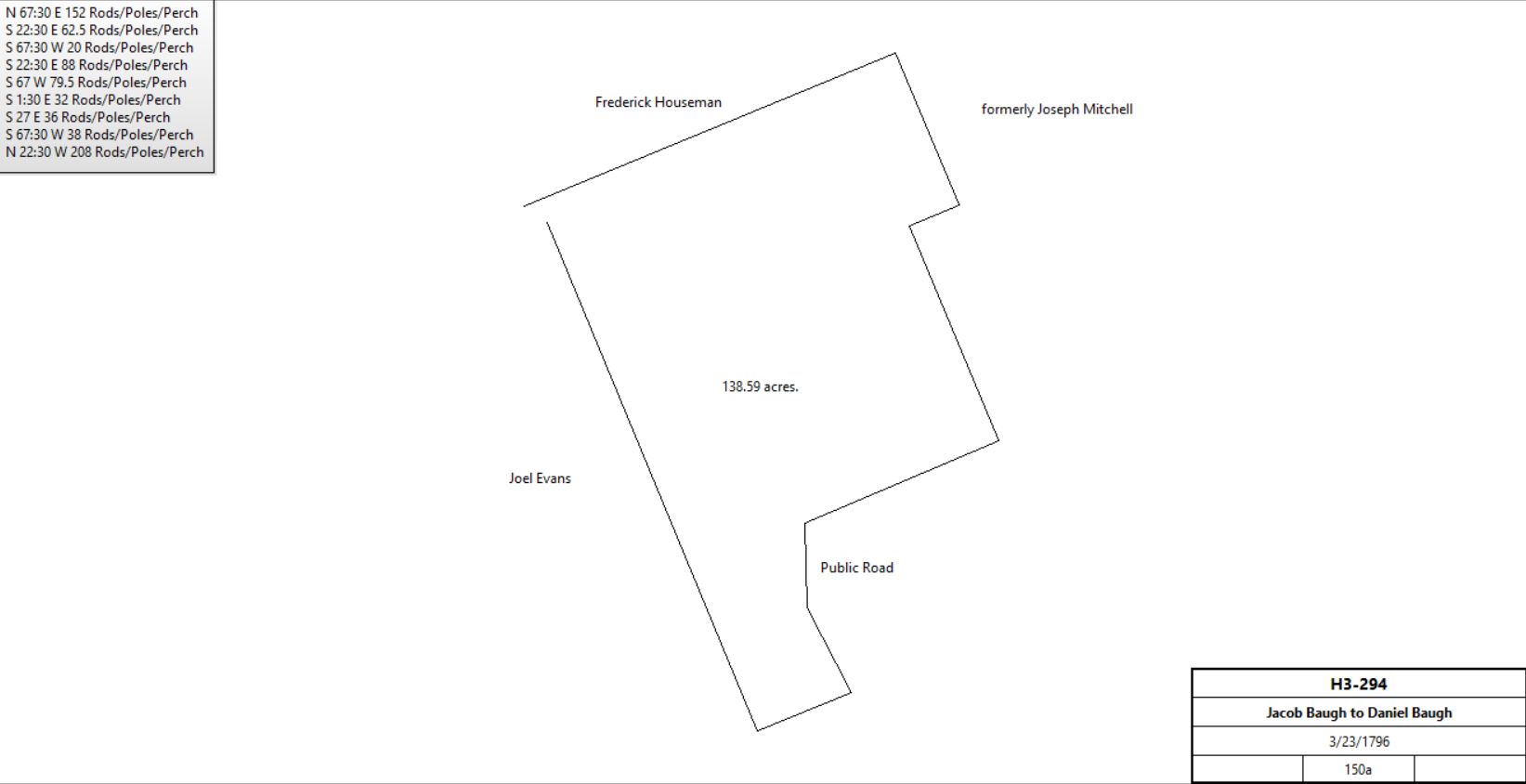
Jacob & Salomi Baugh |
Daniel Baugh, son |
3/23/1796 |
150a, part of 194¾a |
|
H3-294 |
|
Daniel Baugh |
Jacob & Salomi Baugh |
3/29/1796 |
|
|
N2-279 covenant |
Daniel Baugh |
John Baugh |
4/25/1796 |
½ of 150a |
|
G3-464 |
Jacob Baugh |
|
1797 |
10a |
|
tax |
Daniel Baugh |
|
1797 |
162a |
|
tax |
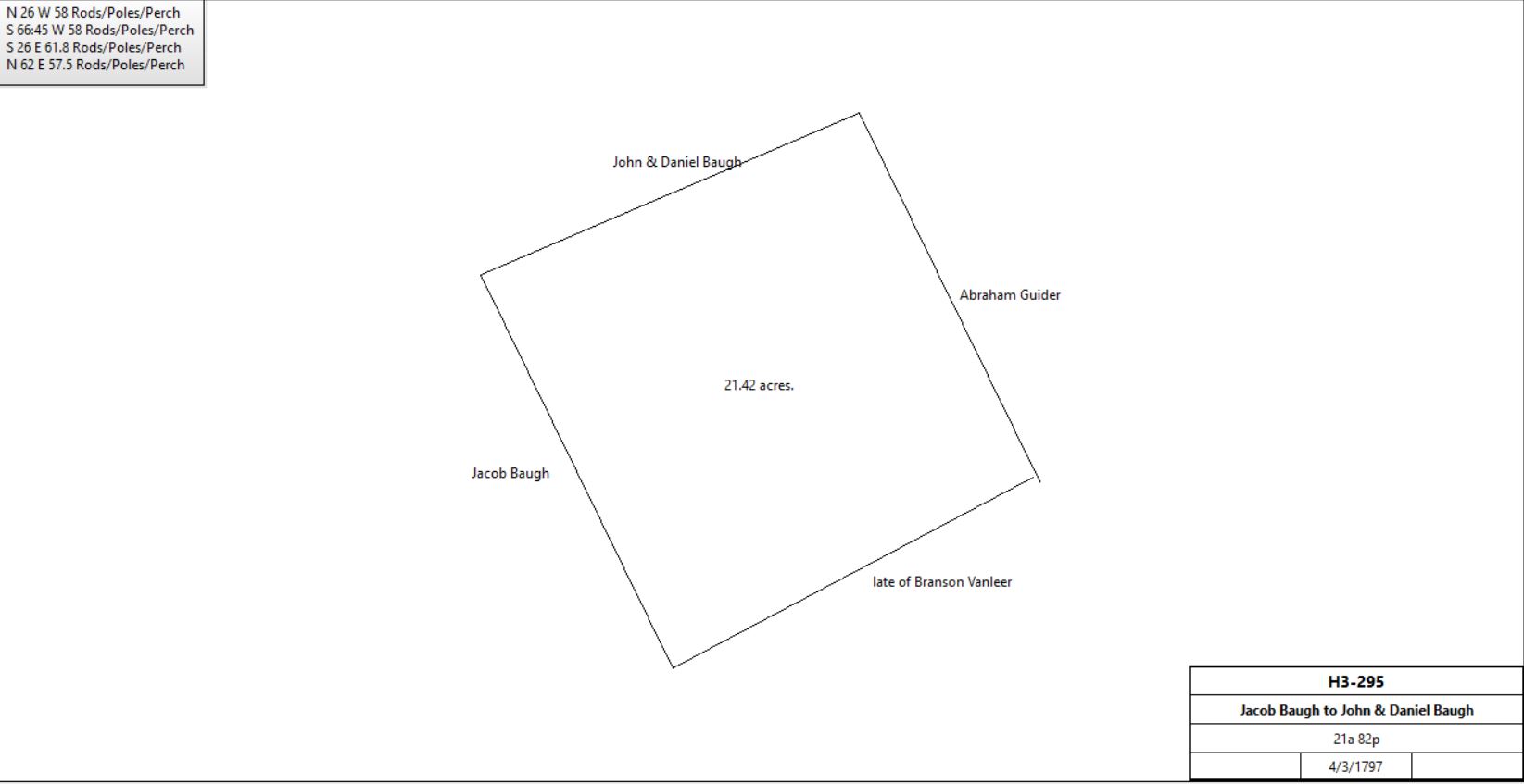
Jacob & Salomi Baugh |
Abraham Guider |
4/3/1797 |
12a |
$300 |
Q2-300; see table AN.2.2.1 |
Jacob & Salomi Baugh |
Daniel & John Baugh |
4/3/1797 |
21a 82p |
|
H3-295 |
|
Jacob Baugh |
|
1798 |
10a |
|
Tax; half of sawmill |
Daniel & John Baugh |
|
1798 |
170a |
|
tax |
Daniel, Jacob & John Baugh |
|
1798 |
10?a |
|
Glass tax; half of sawmill |
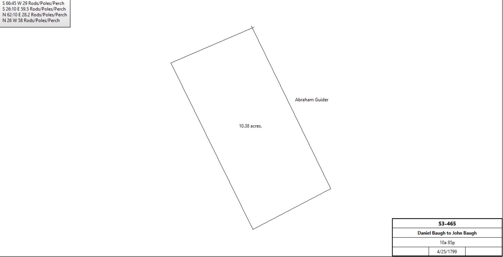
Daniel & Amelia Baugh |
John Baugh |
4/25/1799 |
10a 85p |
£700 |
S3-465 |
|
Jacob Baugh |
|
1799 |
10a |
|
tax |
Daniel & John Baugh |
|
1799 |
150a |
|
Tax; tanners |
Jacob Baugh |
Wife & then children |
2/11/1800 (probate) |
|
|
Will 12/17/1799 |
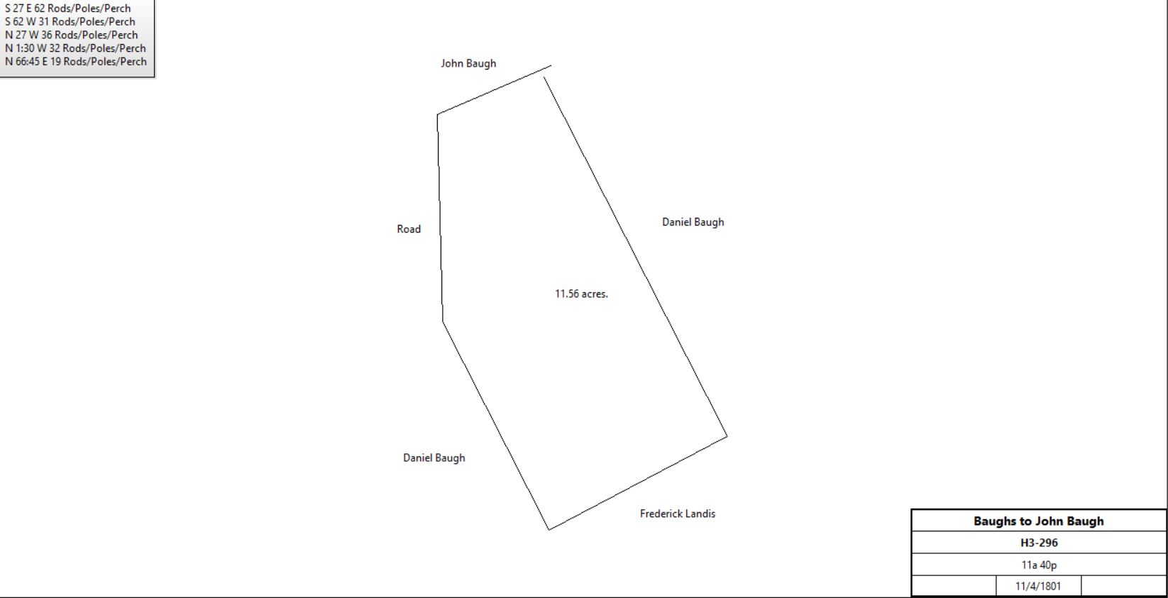
Henry, Jacob, Daniel, Catherine, Ann & Sarah Baugh |
John Baugh |
11/4/1801 |
11a 40p |
|
H3-296 |
|
John Baugh |
|
1821 |
|
|
died intestate |
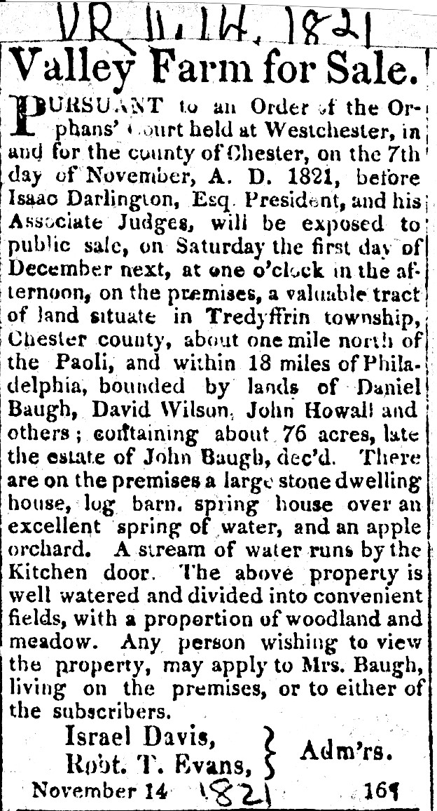
Daily Local 11-14-1821
See Newspaper clipping in Document database for commentary
|
Israel Davis & Robert T. Evans, administrators of the estate of John Baugh |
David Coombs |
3/30/1822 |
78a 24p |
$4,141 95c |
U3-107 |
David Coombs, teacher of Phildelphia, and Rachel, his wife |
Jesse Beitler |
4/6/1836 |
78a 24p |
$4,063 80c |
D4-566 |
Jesse & Elizabeth Beitler of Charlestown |
Jacob Kurtz of East Whiteland |
4/1/1853 |
78a 24p |
$4,200 |
S5-232 |
Henry Kurtz of Tredyffrin |
Thomas Aiken |
3/10/1855 |
78a 24p |
$4,200 |
X5-233 |
Daniel Baugh |
Samuel Baugh |
1858 |
|
|
died |
Joseph Baugh, executor of the will of Daniel Baugh |
Samuel Baugh |
3/23/1861 |
65a 20p + 20a 48p |
$5,894 32c |
R6-335 |
Samuel & Anna Baugh of Philadelphia |
James C. Baugh |
3/28/1861 |
65a 20p + 20a 48p |
$6,000 |
S6-73 |
James C. Baugh |
Thomas Aitken |
4/13/1871 |
20a 48p |
$3,045 |
Z7-199 |
Hall tract |
James C. Baugh |
Thomas Hall |
4/27/1864 |
9a 158.5p |
$850 |
X6-94 |
James C. Baugh |
Thomas Hall |
6/20/1865 |
3a |
$700 |
A7-208 |
James C. & Edith Baugh |
Thomas Hall |
5/15/1871 |
13a 158p |
$1,100 |
Z7-269 |
|
Thomas Aitken |
|
1883 |
96a 2r 17p |
|
Breou’s Altas |
James Baugh |
|
1883 |
44a 1r 13p |
|
Breou’s Atlas |
Thomas Hall |
|
1883 |
23a 3r 36p |
|
Breou’s Atlas |
|
|
|
Table AN.2.2.1
|
From |
To |
Date |
Area |
Cost |
Reference |
|
|
|
|
|
|
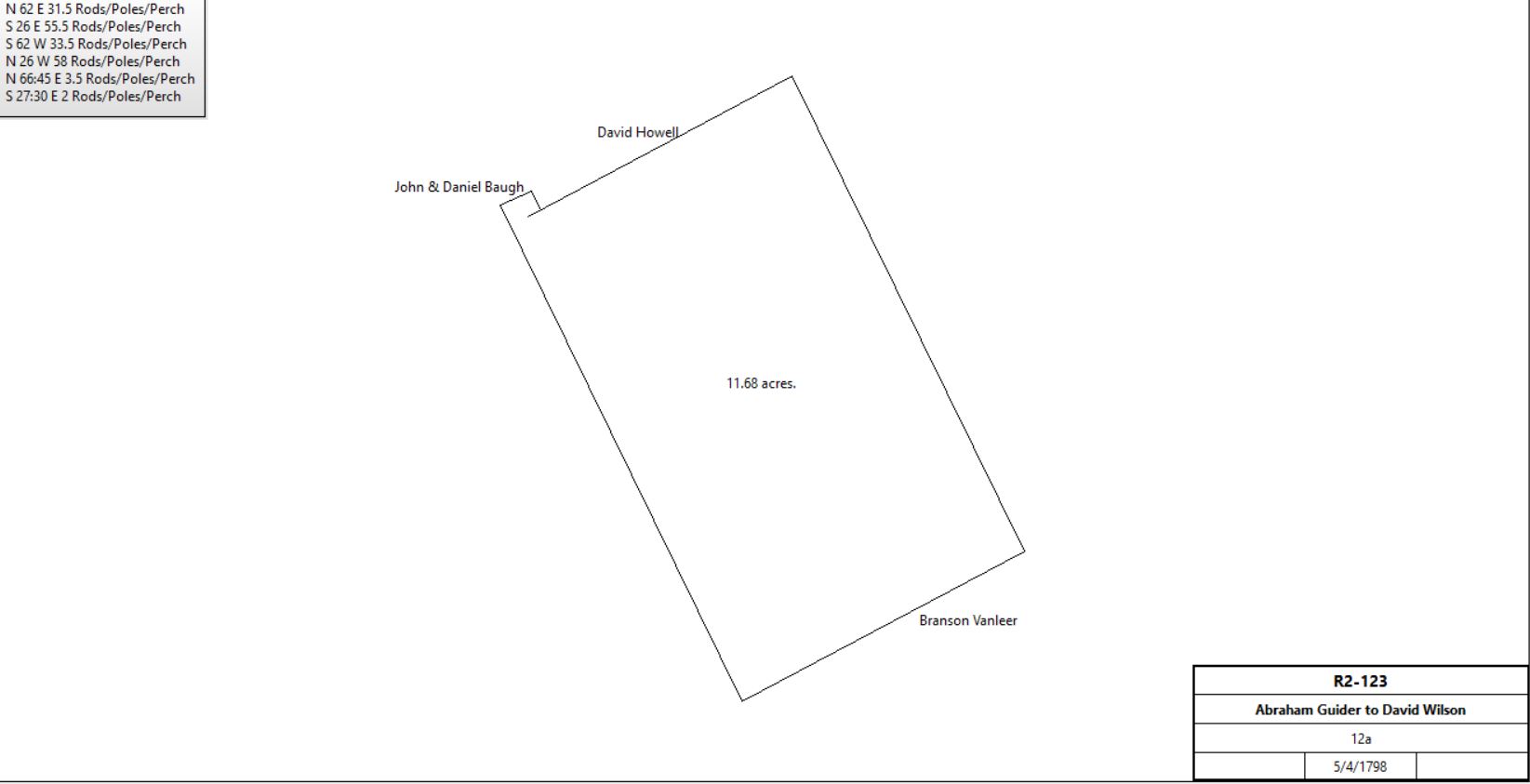
Jacob & Salomi Baugh |
Abraham Guider |
4/3/1797 |
12a |
$300 |
Q2-300; from table AN.2.2 |
Abraham & Hannah Guider |
David Wilson |
5/4/1798 |
12a |
$275 |
R2-123 |
|
David Wilson |
Benjamin Havard |
4/30/1813 |
12a |
$771 |
T3-334 |
|
|
Table AN.3 Thomas David plantation
|
From |
To |
Date |
Area |
Cost |
Reference |
|
|
|
|
|
|
Thomas David |
|
|
50a |
|
See Taylor papers plan |
Patent |
Francis Wayne |
3/8/1745 |
7a 9p |
|
See Patent Survey; Francis Wayne’s other holdings north and south |
Francis Wayne |
Michael Wayne |
12/30/1762 |
|
|
died |
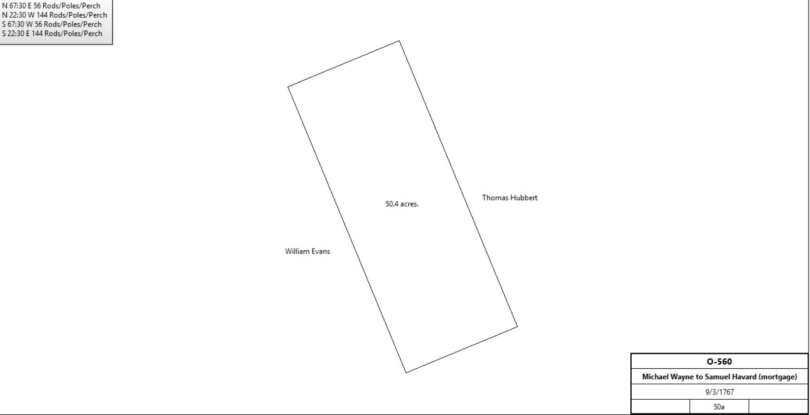
Michael Wayne |
Samuel Havard |
9/3/1767 |
50a. |
£120 |
O-560, Mortgage. |
|
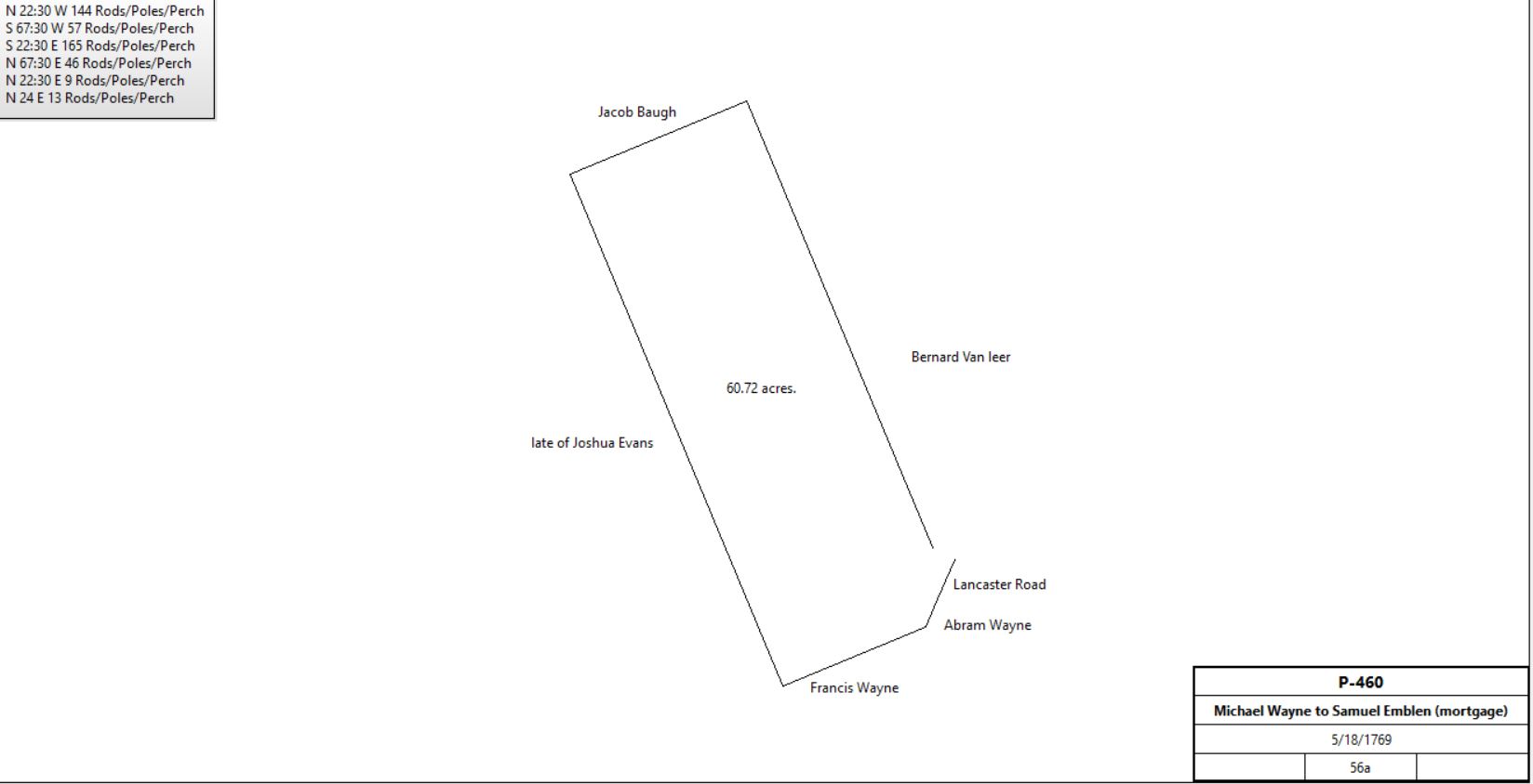
Michael Wayne |
Samuel Emblen |
5/18/1769 |
56a |
£100 |
P-460, Mortgage. |
|
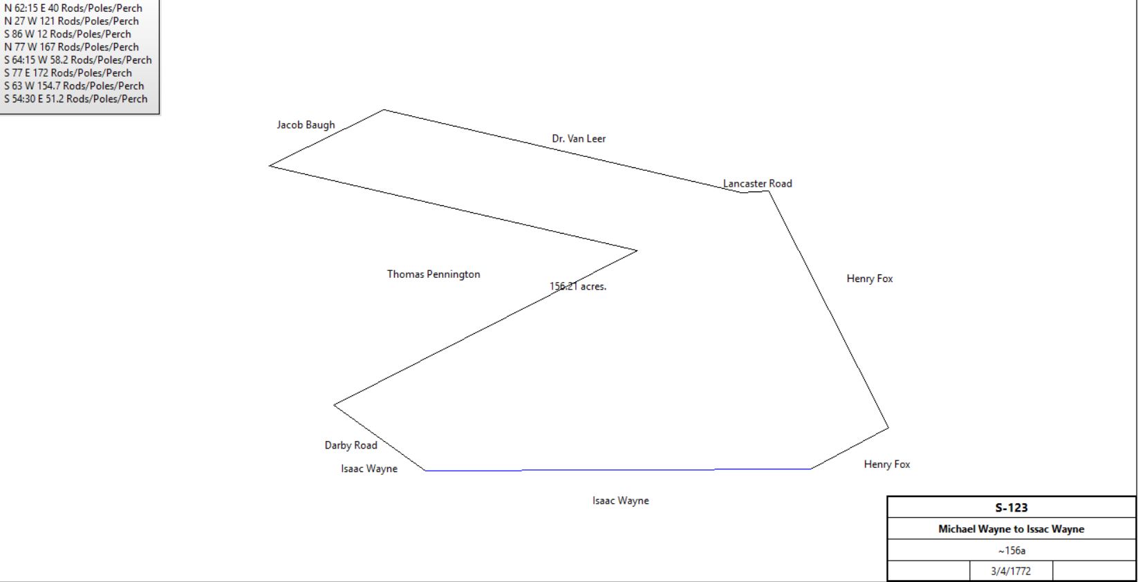
Michael Wayne |
Issac Wayne |
3/1772 |
154a |
£53 17s |
S-123 |
|
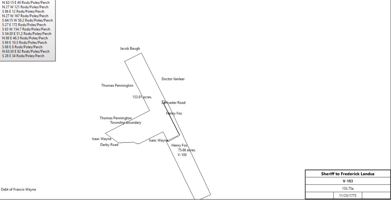
Henry Hayes, Sheriff |
Frederick Landus or Landers |
1773 |
153¾a |
£97 6s 11d |
V-103.& Sheriff’s deed 1-1 Property of Francis Wayne deceased; Michael and Abraham Wayne executors. Writ of Evan Thomas for £80 (72s damages) |
|
Frederick Lantis |
Vanleer? |
|
|
|
No deed for sale of land |
Frederick Lantis |
|
1796 |
30a |
|
tax |
Frederick Landis |
|
1798 |
50a |
|
Glass tax & county tax; neighbor John Parker |
Frederick Lantis |
|
1799 |
50a |
|
tax |
Frederick Landis sr. |
children |
|
|
|
Died 1803; see agreement W2-533 |
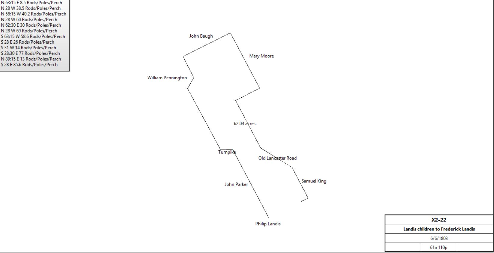
Henry, Philip & Anne Landis, John & Magdalena Good, Jacob Landis |
Frederick Landis jr. |
6/6/1803 |
61a 110p |
£455 10s |
X2-22, release; part of 168a 49p; Tredyffrin & Easttown |
|
Henry Landis et al |
Philip Landis |
6/6/1803 |
90a 39p + 16a 60p |
£1638 5s 8d |
X2-24 release; Tredyffrin & Easttown |
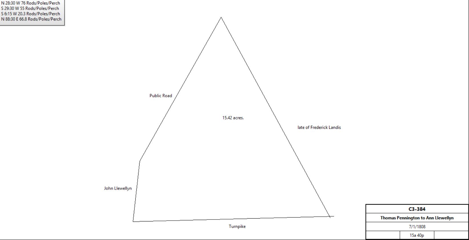
Thomas & Judith Pennington, Deborah Pennington |
Ann Llewellyn |
7/1/1808 |
15a 40p |
|
C3-384; see table V.1 |
|
James & Sarah McKeever, Ann Landis |
Ephraim Hughes |
3/30/1830 |
41½a (part of 61a 110p) |
|
C4-407 |
James Sloan |
|
1831 |
Part of 74a |
|
See table L.2 |
John Sloan (trustee of Julian Sloan) |
George & Julianne Prager or Erager |
4/2/1835 |
|
$1 |
K4-158 |
Joseph Taylor (sheriff) |
John Hutchinson |
12/17/1839 (sale) |
15a 40p |
|
S4-488; deed poll; debt to Joshua Evans by George & Julianne Prager (mortgage) |
John & Jane Hutchinson |
Robert Devine |
6/1/1846 |
15a 40p |
$1250 |
D5-414 |
|
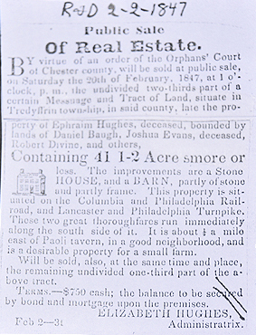
Elizabeth Hughes, administrix of Ephraim Hughes |
Robert Devine |
3/16/1847 |
41½a |
$1527 |
E5-319. ⅔ part? |
Robert & Ann Devine |
William P. Hamm |
8/4/1865 |
41½a + 15a 40p |
$6424 33c |
A7-258 |
William P. & Mary Ann Hamm |
Henry Root |
4/3/1868 |
41½a + 15a 40p |
$6700 |
L7-263 |
Henry & Almira Root |
Hugh Steen |
2/15/1869 |
99p |
$1,000 |
O7-160; messuage |
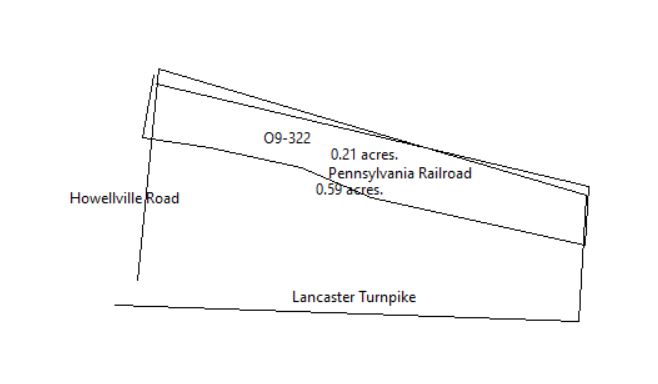
Hugh & Mary Steen |
Pennsylvania Railroad |
7/11/1883 |
0.232a |
$10 |
O9-322 |
|
|
|
|
|
|
|
Hugh Stein & John Beitler +(execs of Henry Root) |
Nathan Broomall |
12/29/1877 |
51a 85p |
$4950 |
B9-53; messuage |
Nathan Broomall |
|
1883 |
51a |
|
Breou’s Atlas |

Nathan Broomall tract from 1887 atlas
|

Dr. Agnew tract from 1900 atlas
|

Dr. Agnew tract from 1913 atlas
|

Agnew tract from 1933 atlas
|

Dr. Agnew tract from 1950 atlas
|
|
|
Table AN.3.1 woodland north of Lancaster Turnpike
|
From |
To |
Date |
Area |
Cost |
Reference |
|
|
|
|
|
|
Henry Landis et al |
Philip Landis |
6/6/1803 |
90a 39p + 16a 60p |
£1638 5s 8d |
X2-24 release |
Philip & Catherine Landis |
Benjamin Ramsay |
4/15/1816 |
1a 1r 26p |
$289 56p |
M3-252 |
Philip & Catherine Landis |
Joshua Evans & Nathan Pawling |
4/15/1816 |
4a 44p, part of 16a 60p |
$1,026 |
C4-173 |
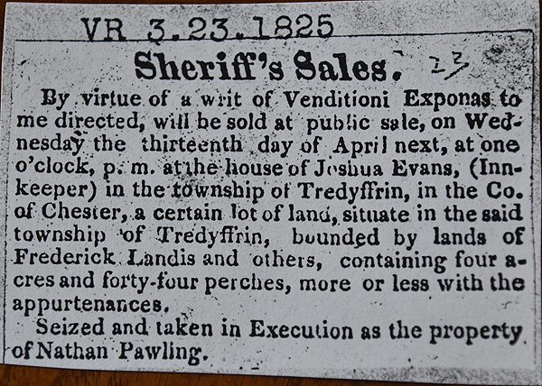 Sheriff's sale Sheriff's sale
|
Jesse Sharp, sheriff, debt of Nathan Pawling |
Joshua Evans |
4/13/1825 |
4a 44p |
$30 25c |
C4-174 |
John D. Evans |
Samuel Brinkley Hayman |
2/27/1847 |
4a 44p |
$800 |
W6-357 |
Elizabeth Hayman |
Children |
|
|
|
Died; Will Book W-91 |
William & Elizabeth Hayman |
Nathaniel Lawrence |
4/2/1864 |
2a 47p + 2a 47p |
$400 |
W6-421 |
William & Elizabeth Hayman, Charles & Mary Hayman, Margaret & Sarah Hayman |
Nathaniel Lawrence |
4/2/1864 |
4a 44p |
$1,225 |
W6-423 |
Nathaniel & Jane Lawrence |
Edward Fry |
2/11/1869 |
8a 138p |
$2,275 |
U7-86 |
Edward Fry |
Mary A. Beaver |
7/1/1882 |
8a 63p |
$3,400 |
R9-283; remainder to Penn RR |
Beaver |
|
1883 |
8a |
|
Breou’s Atlas |
|