|
Note: in these deed histories distances are quoted in perches (p) of length 16.5 feet. Areas are quoted in acres (a) and square perches (p). There are 160 square perches to an acre. In a few cases roods (a quarter of an acre) are also used.
|
From |
To |
Date |
Area |
Cost |
Reference |
|
|
|
|
|
|
Penn |
David Powell |
1/28/1705-6 |
1000a |
|
|
David Powell |
Thomas David/Davy |
4/2/1708 |
200a |
£58 |
B-221 |
 |
Thomas David |
|
1715 |
|
|
Not in tax list |
Thomas David |
|
1718 - 1737 |
|
|
In Tredyffrin tax lists |
Thomas David |
Samuel Lilly, Fuller & Dyer |
2/6/1739 |
½a |
15s |
O2-518 – 999 year lease |
Thomas David |
Methusaleh Davis, son |
3/7/1741 |
200a |
|
|
Penn |
Methusalot Davis |
4/12/1745 |
200a |
|
Taylor Plan and subsequent survey document, Survey C39-126; Phila. Patent A11-400; confirmation |
Methusaleh Davis |
Wm. Coleman and James Pemberton |
11/19/1748 |
200a |
£140 |
G-335 Mortgage |
Methusaleh Davis |
Wm. Coleman and James Pemberton |
4/16/1750 |
200a |
£220 |
G-599 Mortgage |
Thomas David |
Methusaleh Davis |
3/27/1741 |
200a |
|
G2-387 Release; see description as deed B-221 |
Methusale Davis |
|
1750 |
300a |
|
Pennsylvania Gazette |
Methusaleh & Elizabeth Davis |
James Davis |
11/27/1750 |
200a - ½a (St Peter’s land) |
|
O-536 |
James Davis |
Israel Davis, son |
10/20/1757 |
133a |
£150 |
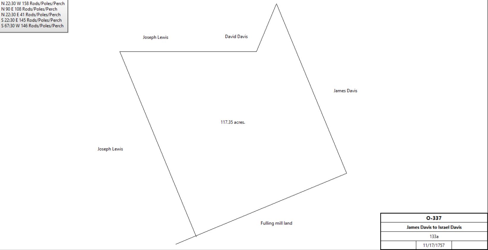
O-337 |
 |
James & Israel Davis |
Jacob Davis |
Bef 1759 |
50a |
|
|
Jacob Davis |
James & Israel Davis |
12/7/1758 |
50a |
|
M-77 Covenant |
James Davis |
William George |
2/20/1761 |
352a |
£150 per annum |
M-161 Mortgage |
Israel & Hannah Davis |
Amos Strettell |
8/13/1764 |
133a |
|
P-4 Mortgage. Paid off 8/2/1767; see deed plan |
See Rees Rhythey table |
|
|
|
|
|
Israel & Hannah Davis |
David Jones |
2/5/1767 |
9a 3r 30p (part of 133a) |
£55 |
T-61, not fulling mill; |
Israel Davis |
|
1767 |
90a |
|
Last entry in tax records |
Israel Davis |
John Cloyd |
|
125a |
|
Unrecorded; see table F.1 |
John Cloyd |
|
1774 |
120a |
|
First entry in tax records |
|
|
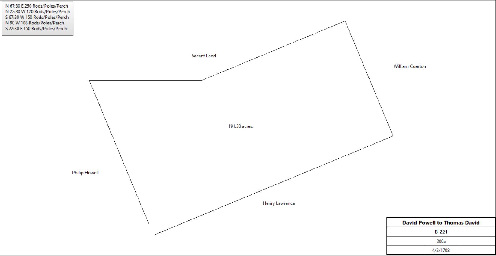
B-221 Deed. On 2 Apr 1708 David Powell of the City of Philadelphia, yeoman, to Thomas David of Great Valley in the county of Chester. Whereas there is a parcel of land in the Welch Tract bounded by land of Henry Lawerence, William Cuarson & Phillip Howell, containing 200 acres, part of 1000 acres the present commissioners granted to David Powell by deed dated 28 Jan 1705. Now David Powell for £58 grants to Thomas David a tract containing 200 acres. Beginning at a post in a line of Henry Lawrence’s land thence East North East 250 perches to another stake set in the ground in the line of William Cuarton’s land thence North North West by a line of trees & vacant land 120 perches to a third stake set in the ground thence West South West by a line of marked trees and vacant land 150 perches thence West 108 perches to a post set in the ground thence South South East 150 perches by a line of marked trees dividing it from land belonging to Phillip Howell to the place of beginning. Signed David Powell. Delivered in the presence of Mathew Robinson, Sarah Robinson, John Thomas, David Loyd & Richard Heath. Recorded 31 May 1708.
Pennsylvania Gazette
To be sold by publick vendue, on the 3d of September next … a plantation, situate in the township of Tryduffryn, in the Great Valley, Chester county, 22 miles from the city of Philadelphia, and convenient to several merchant-mills, containing about 300 acres of very good land, 120 acres thereof clear’d, about 40 of which is good meadow, a great part thereof upland, well water’d, and good convenience of making more, the whole plantation having several streams and live springs of water in it, the corn-land fresh, the wood-land well timber’d, and good convenience of buring lime. There is a good stone-house on the place, new stone barn, stable, cow-house, and spring-house, and a large thriving orchard. Likewise to be sold at the same time and place, a large stock of horses, mares and colts, cows, steers, young cattle and sheep, implements of husbandry, and sundry sorts of household goods.
M-77 On 7 Dec 1758 Be it known unto all persons whom these presents may concern, that whereas my father James Davis & my brother Israel Davis both of Tredyffrin, yeomen, by deed granted unto me, Jacob Davis of Tredyffrin a tract of land in Tredyffrin bounded by land lately belonging to Joseph Bartholomew, dec., land of James & Israel Davis, the fulling mill dam, containing 50 acres excepting what is in the said deed of conveyance which is containing & inserted that the said James Davis & Israel Davis have a fulling mill & dam, to dam the water for the said mill. I, the said Jacob Davis, have agreed to abide with said exception with my said father, James Davis & brother Israel Davis.
O2-518 In consideration of 15 shillings said Thomas David does hereby grant, lease, let and to farm let unto Samuel Lilly his heirs and executors, Admins, and assigns all that piece or parcel of land in said Twp., Beginning at a black walnut tree standing at the east corner of the tail race of ye fulling mill belonging to the said Samuel Lilly to the line that divides between the land of said Thomas David and the land of the said Samuel Lilly lying southerly thereof along the said line about 20 perches to the place of beginning, where the said line crosseth the creek called the Valley creek, thence down the several courses of the said creek to the place of beginning. Containing by estimation half an acre - for and during the term of 999 years.
G-335 Mortgage. On 19 Nov 1748 Methusaleh Davis of Tredyffrin, yeoman, to William Coleman & James Pemberton of the City of Philadelphia, merchants & executors of the will of Samuel Powell, Jr. Methusaleh Davis stands bound to William Coleman & James Pemberton for £280 on condition of payment of £140 plus interest to William Coleman & Fames Pemberton on or before 19 Nov 174 9. Methusaleh Davis for better securing said payment granted to William Coleman & James Pemberton a tract in Tredyffrin bounded by land late of Henry Lawrence, land late of William Cuarton & land of Phillip Howells, containing 200 acres, excepting 1 acre which Methusaleh Davis by deed dated 6 May 1745 granted to William Moore & others for the members if the St. Peters Church in Tredyffrin. Signed Methusalah Davis. Delivered in the presence of Joseph Galloway & Arthur Forster. Recorded 9 Dec 1748.
G-599 Paid off by James Davey 2/19/1755.
Mortgage. On 16 Apr 1750 Methusaleh Davis of Tredyffrin, yeoman, to William Coleman & James Pemberton of the City of Philadelphia, merchants & executors of the will of Samuel Powell, Jr., late of Philadelphia, merchant, dec. Methusaleh Davis stands bound to William Coleman & James Pemberton for £440 conditioned on payment of £220 on 16 Apr 1751, the same being monies & estate of the children of Samuel Powell, in the hands of the executors which they were directed by the Orphans Court 18 Nov 1747, to put out at interest. Methusaleh Davis to better secure said payment grants to William Coleman & James Pemberton a tract in Tredyffrin bounded by land late of Henry Lawrence, land late of William Cuarton & land of Phillip Howell, containing 200 acres. Signed Methusaleh Davis. Delivered in the presence of Paul Isaac & Peter Miller, Jr. Recorded 4 May 1750.
Beginning at a post in the line of late of Henry Lawrence, by same land and land late of William Cuarton ENE 250 perches to a post, thence by vacant land NNW 120 perches to a post, WSW 150 perches to a post, West 108 perches to a post in the line of Philip Howell’s land, thence by same SSE 160 perches to the place of beginning.
O-536 & See deed plan
Beginning at a post in a line of marked trees of Henry Lawrence’s land, thence ENE 250 perches to a post in William Cuarton’s land, thence NNW by a line of trees and vacant land 120 perches to a stake, then WSW by a line of trees and vacant land 150 perches to a post, then West 108 perches to a post, then SSE 160 perches by a line of marked trees dividing it from land of Philip Howell to the place of beginning.
Excepting ½acre leased by Thomas David to Samuel Lilly, dated 2/6/1739. Recorded in O2-518.
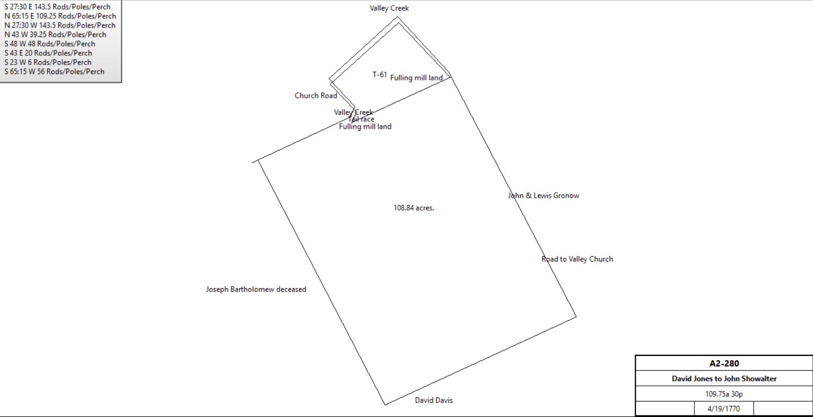
P-4 Beginning at a heap of stones, a corner of land belonging to Joseph Bartholomew deceased, and a corner of Joseph Lewis’ land, thence by said Lewis’ land WNW (should this be NNW?) 158 perches to a corner, thence by said Lewis’ and David Davis’ land East 108 perches to a stake, thence NNE 41 perches to a stake, thence upon a direct course about SSE 145 perches to a stake in the line of another tract of James Davis, thence WSW 146 perches by said James Davis’ land, by some land called the Fulling Mill land, and on the line of Bartholomew to the beginning.
|
Table F.1 – Monday - Acker Property
|
From |
To |
Date |
Area |
Cost |
Reference |
|
|
|
|
|
|
Israel Davis |
John Cloyd |
|
|
|
unrecorded |
John Cloyd |
|
1774 |
120a |
|
First entry in tax returns |
John Cloyd |
|
10/8/1782 probate |
|
|
Will dated 10/30/1781 |
Execs. of John Cloyd (Sarah & David Cloyd) |
John Thomas |
4/1/1783 |
125a |
£1876 |
Z-346 |
John Thomas ux |
David Cloyd |
1784 |
125a |
|
Mortgage B-198 Satisfied 1788 |
John Thomas ux |
John Steinmentz |
1785 |
135 & 62+ |
|
Mortgage C-112 |
Sheriff (estate of John Thomas) |
John Steinmentz |
5/1/1793 |
62+a |
|
Sheriff’s Deed 1-82 |
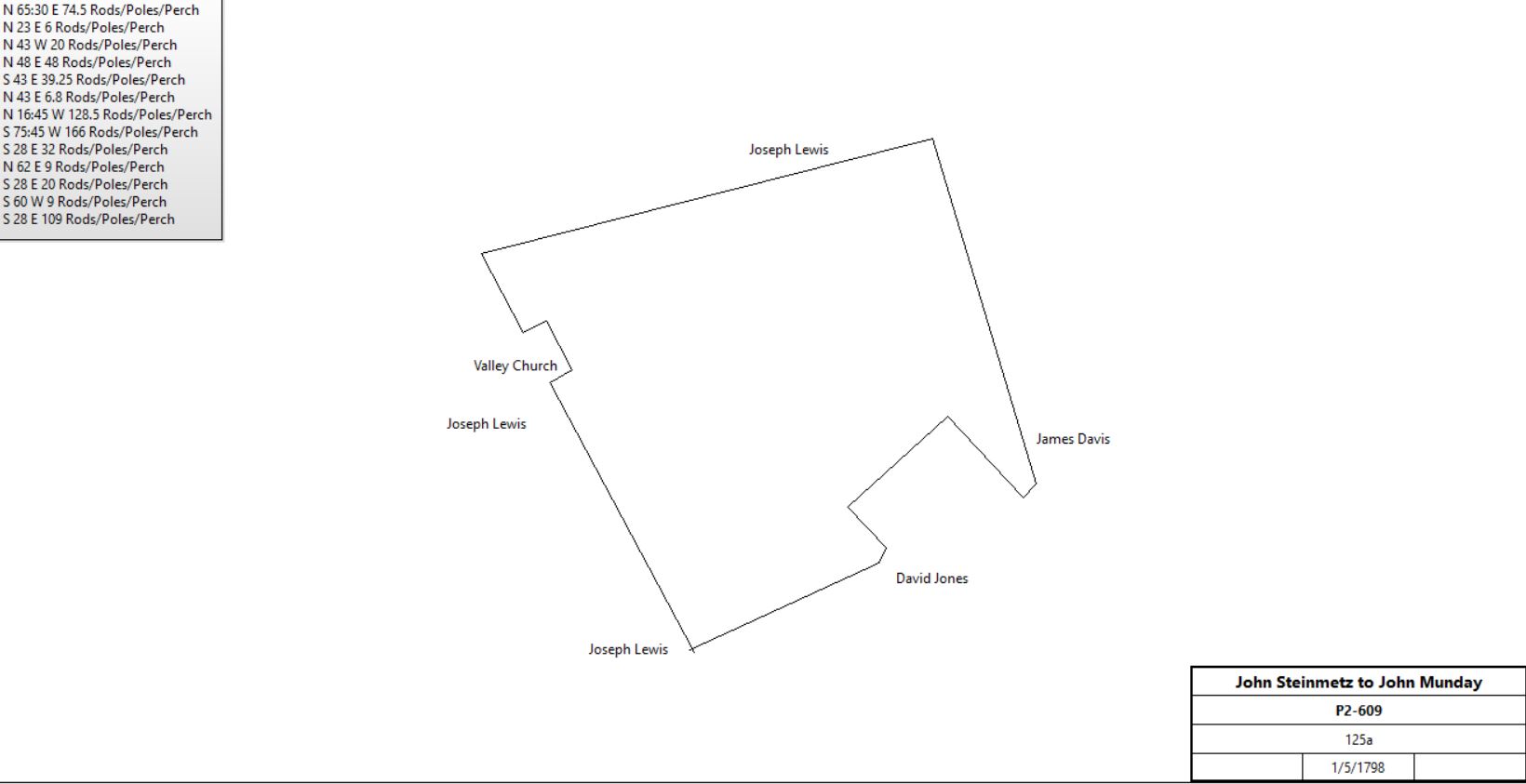
John Steinmentz |
John Munday |
1/5/1798 |
125a |
£1500 |
P2-609 |
 |
John Munday |
|
1798 |
124a |
|
Glass Tax |
Sheriff, debt of John Munday |
John Steinmentz |
3/28/1801 |
|
£910 |
sale |
Sheriff |
John Steinmentz |
5/22/1802 |
|
|
deed |
John Steinmentz |
John Steinmentz, John H. & Sarah Brinton, Elizabeth & Daniel Steinmentz |
|
|
|
Will |
John Steinmentz, John H. & Sarah Brinton, Elizabeth & Daniel Steinmentz |
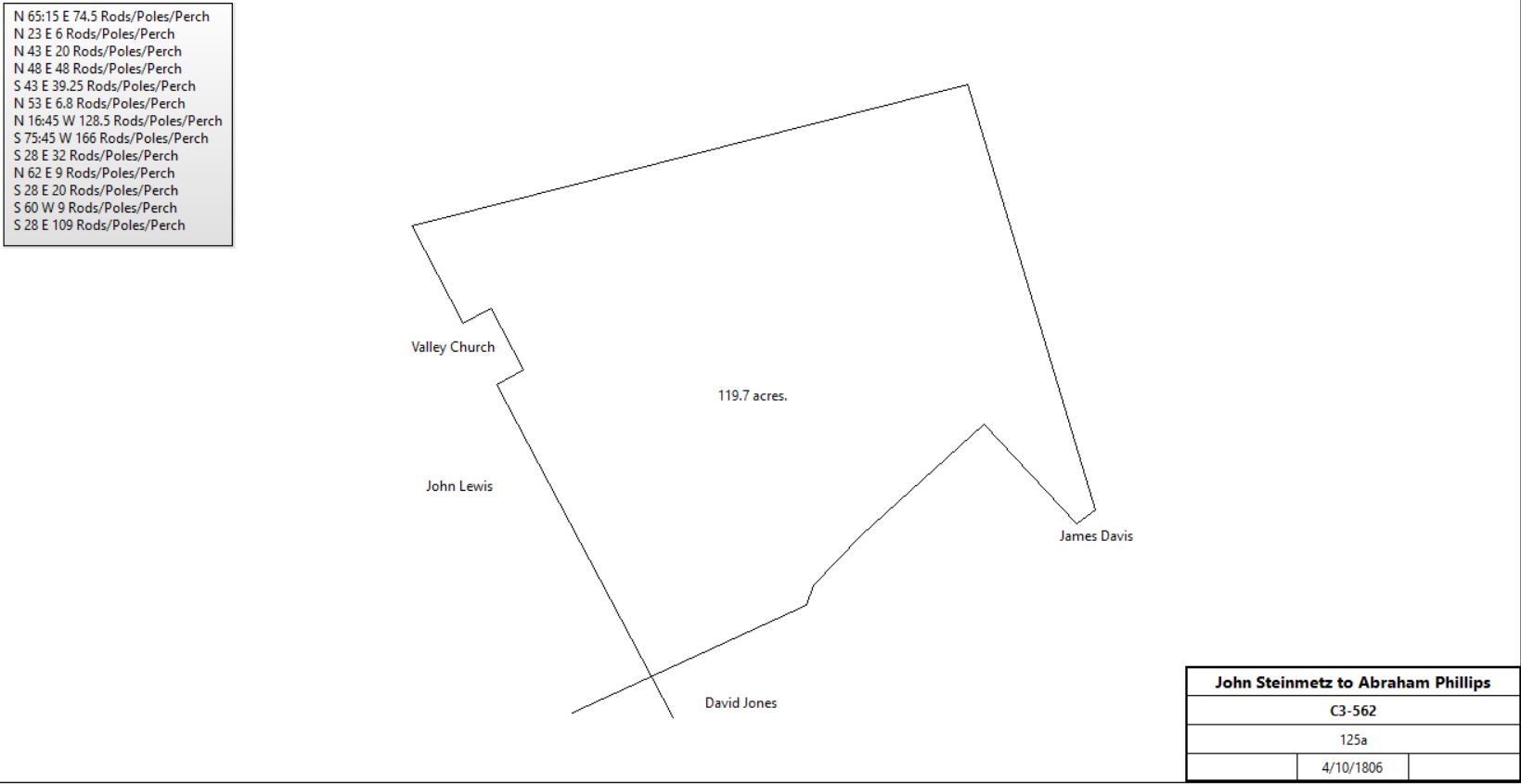
Abraham Phillips |
4/10/1806 |
125a |
$4333 33c |
C3-562 |
 |
Cromwell Peirce (sheriff) |
Abram Phillips |
12/19/1811 |
5a 80p |
|
Not recorded |
Abraham Phillips |
William Warner |
4/1/1812 |
124½a & 5a 80p |
$7,800 |
I3-177 |
William Warner |
John Miller |
4/1/1813 |
124½a & 5a 80p |
$8,840 |
I3-179 |
John Showater |
Conrad Acker |
4/1/1820 |
6a 146p (part of 9a 3r 30p) |
|
Y3(71) – 52 see table F |
John Miller |
Conrad Acker |
4/1/1820 |
124.5a + 5a 80p |
$13,750 |
S3-21 |
Peter Acker |
|
1830 |
|
|
Road deed |
Conrad Acker |
|
1834 |
|
|
Road deed |
Conrad Acker |
Samuel Acker |
1/11/1837 probate |
|
|
Will dated 9/30/1833 |
Samuel Acker |
Mary in lifetime, then son Jack Acker |
2/2/1880 |
127+a |
|
Will dated 12/17/1878 |
Mrs. S. Acker |
|
1883 |
124a |
|
Breou |
Jack Acker ux |
H. H. Gillyson? |
9/7/1882 |
|
|
Misc. 19-249 |
H. H. Gillyson? |
Jack Acker |
3/19/1883 |
|
|
S9-100 (by direction of court of common pleas) |
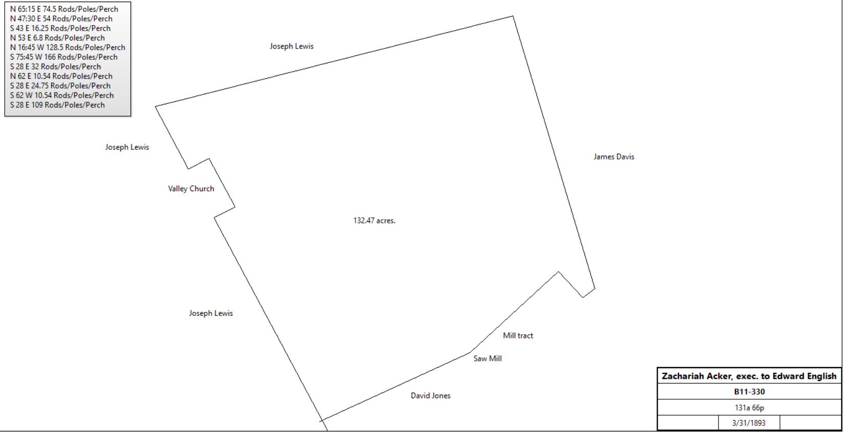
Zachariah Acker, executor of will of Mary Acker |
Edward B. English |
3/31/1893 |
131a 66p |
|
B11-330 |
 |
|
Table F.2 Gronow – Andrews Property
|
From |
To |
Date |
Area |
Cost |
Reference |
|
|
|
|
|
|
James Davis |
|
1767 |
400a |
|
Tax return |
John Penn |
James Davis |
5/26/1766 |
|
|
By decision of Board of Property portion of right of Francis Allison allocated to James Davis see Y2-253. |
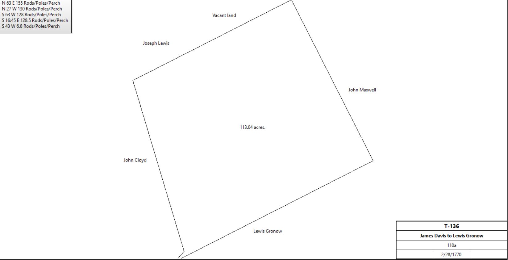
James & Elizabeth Davis |
Lewis Gronow |
2/28/1770 |
110a (part of 200a) |
£650 |
T-136 |
 |
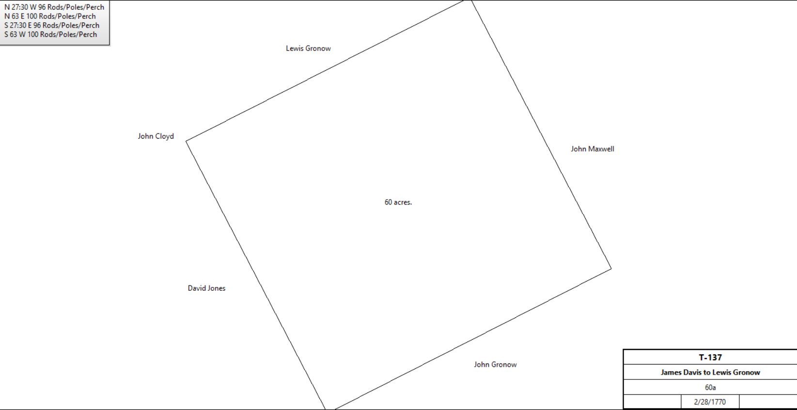
James & Elizabeth Davis |
Lewis Gronow |
1770 |
60a |
|
T-137; see table J.3 |
 |
Lewis Gronow |
Mary Robinson (nee Bull), Isabella Peirce (nee Bull) nieces |
11/3/1782 |
|
|
Will |
Sheriff (Ezekial Leonard). Estate of Lewis Gronow |
Thomas Bull |
6/17/1789 |
110a+ 60a |
|
Sheriff’s Deed 1-47; messuage |
Sarah Bull, head of household |
|
1790 |
|
|
Census: 3 females, 1 male 0 - 16 |
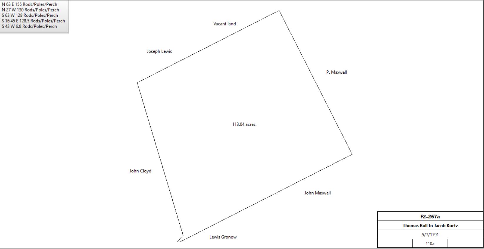
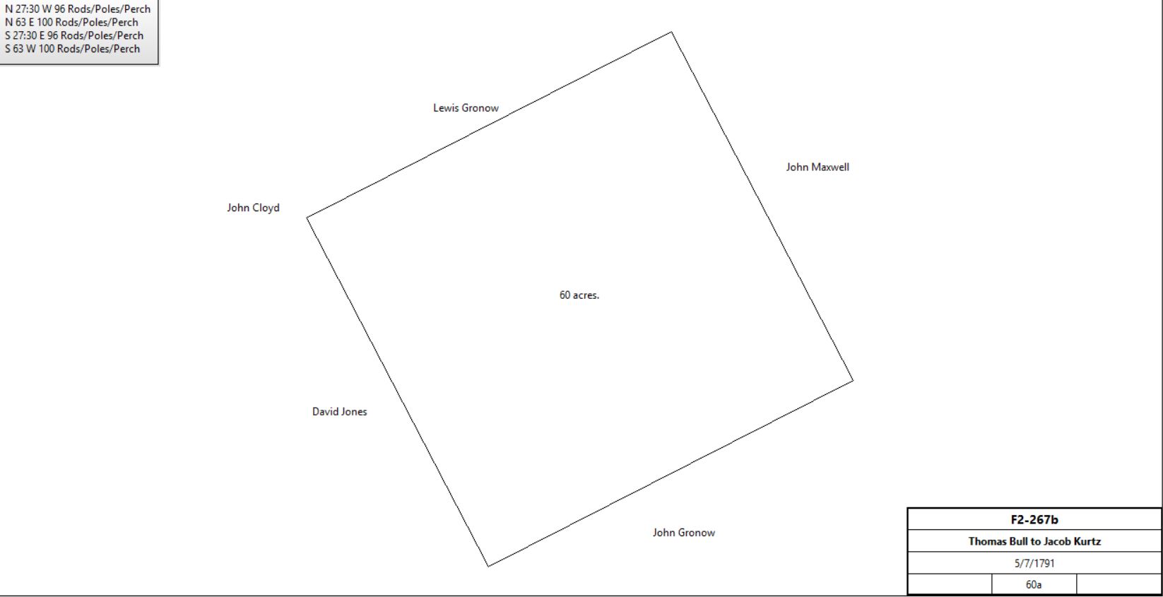
Thomas & Ann Bull of East Nantmeal |
Jacob Kurtz |
5/7/1791 |
110a + 60a |
£1000 |
F2-267; messuage |
 |
 |
Jacob Kurtz |
|
1798 |
169a |
|
Glass tax: stone house 33’ x 24’ |
Sarah Bull |
|
1798 |
33a |
|
Glass tax; tenant Benjamin Wrap; Owners Mary & Isabella Bull |
Jacob & Barbara Kurtz |
Abraham Kurtz |
11/19/1801 |
3 tracts; 85½a (Tred.) + 5a 15p + 6a (both Charlestown) |
£1283 |
T2-681; see deed plan |
Abraham & Elizabeth Kurtz |
Samuel King |
4/1/1803 |
2 tracts; 85½a + 6a |
£2,000 |
Y2-62 |
John, David & Elizabeth Maxwell |
Samuel King |
4/12/1806 |
10a + 10a |
£2? |
G3-28 |
Jacob & Barbara Kurtz |
Samuel King |
2/23/1807 |
14a 6p |
£400 |
G3-27 |
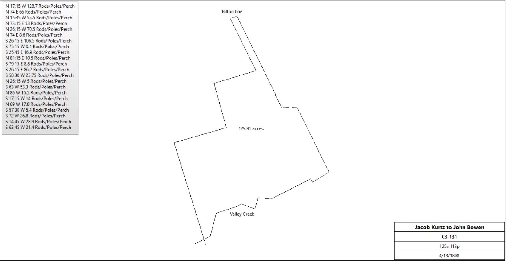
Jacob Kurtz |
John Bowen |
4/13/1808 |
125a 113p & 2nd tract (Charlestown) |
£3032 16s |
C3-131 part of F2-267. Included messuage |
 |
Samuel & Catherine King |
Jacob Longacre |
4/2/1812 |
5 tracts: 85.5a, 6a, 10a, 10a, 14a 6p |
$9600 |
I3-150; deed plans described but not drawn |
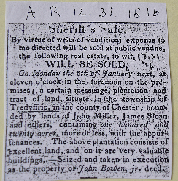
American Republican 1816-12-31
See Newspaper clipping in Document database for commentary |
Sheriff, Cromwell Peirce, debt of John Bowen |
Samuel Davis |
1817 |
|
|
Sheriff’s deed 2-82 |
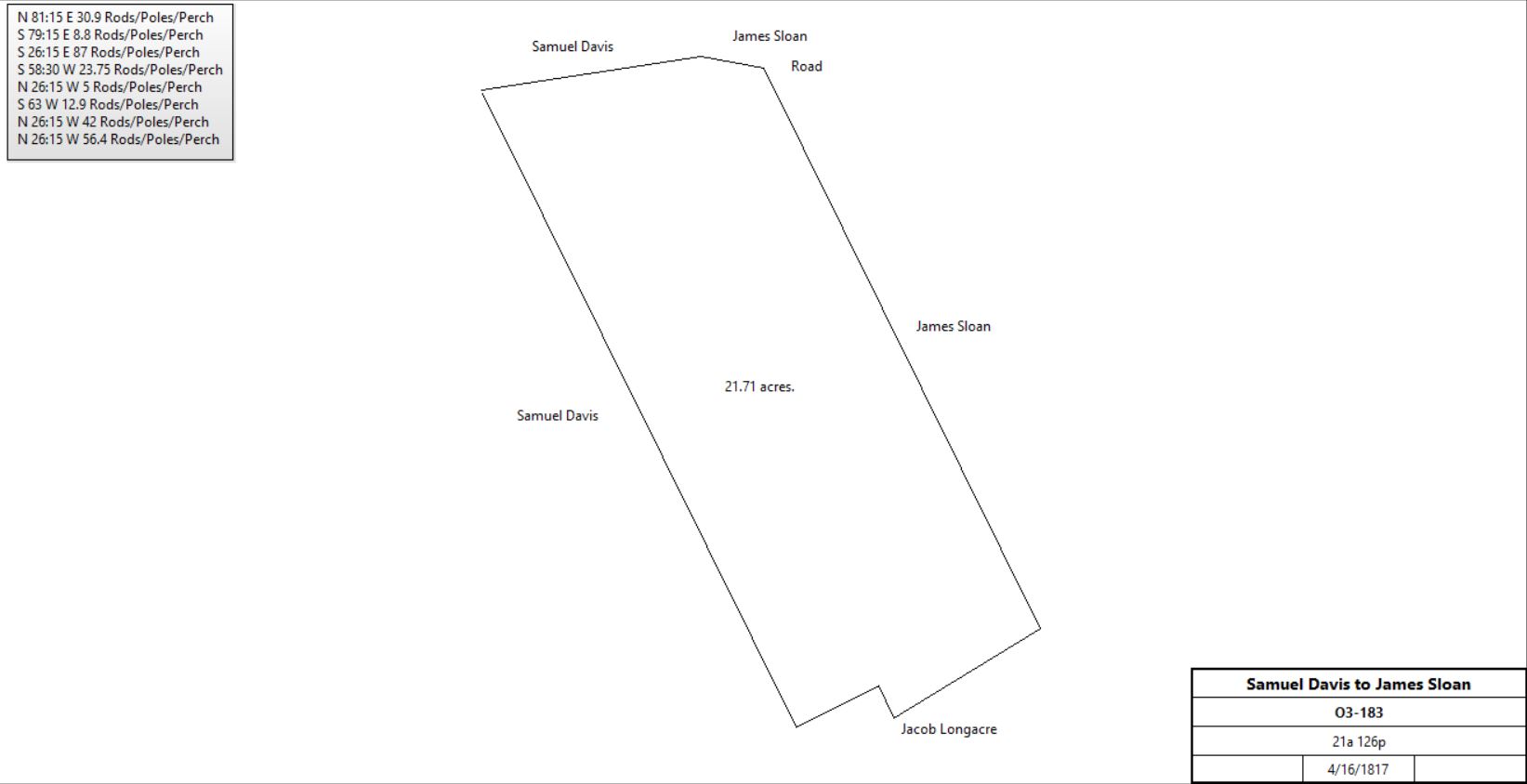
Samuel & Elizabeth Davis |
James Sloan |
4/16/1817 |
21a 126p |
$2,587 87c |
O3-183 |
 |
Cromwell Peirce (sheriff) – goods of John Havard Davis & William Davis?? |
Samuel Davis |
2/10/1817 |
100a |
|
R3-490; deed poll. Mentions H2-357 lease. Woodland but all seems to be in Charlestown |
Village Record 2-4-1818 (not 1827)
See Newspaper clipping in Document database for commentary |
Samuel Davis of Willistown |
|
1819 (will July 7th; probate August 16th) |
|
|
died |
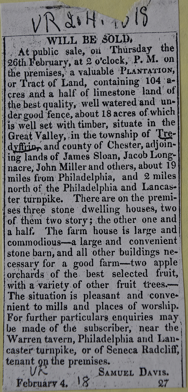
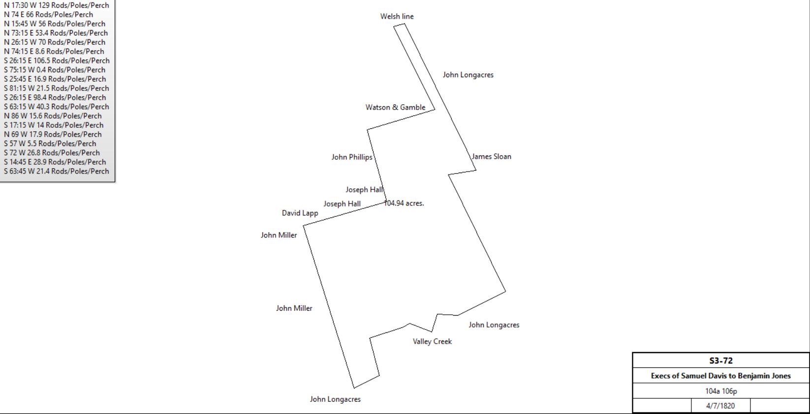
Execs. of Samuel Davis (John G. Bull & Joshua Evans) |
Benjamin Jones |
4/7/1820 |
104a 106p |
$9000 |
S3-72; re Samuel Davis will 7/7/1819 - sell plantation in Tredyffrin where Seneca Radcliff now lives. |
 |
|
from the American Republican
November 10, 1829
PUBLIC SALE
Will be offered at public sale, on fourth day the 9th of December next, a VALUABLE PLANTATION and tract of land, situate in the Great Valley, Tredyffrin township, Chester co., containing 104 1-2 acres of the best quality of limestone land; adjoining the lands of Peter Acker, Conrad Acker and others. There is a good apple orchard on the premises, and a sufficient quantity of woodland and meadow watered by Indian Run; the remainder is divided into convenient fields. The land is well adapted to the raising of every kind of grain - the whole of it having a southern exposure. The buildings are two two story houses - the mansion large and commodious; a large barn, granary, milk house, wagon house and hay house, all substantially built of stone - and a frame smithshop. On the property is a lime kiln , and an inexhaustible quarry of lime stone. The property is in a good neighborhood, convenient to mills and places of worship, and within two miles of the Lancaster turnpike. Any person wishing to view the property will apply to the subscriber living thereon.
BENJAMIN JONES
|
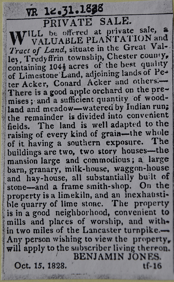
Benjamin & Ann Jones |
Henry Detwiler |
4/2/1830 |
104a 16p |
$7,038 55c |
C4-426 |
Henry Detwiler |
|
1834 |
|
|
Road deed |
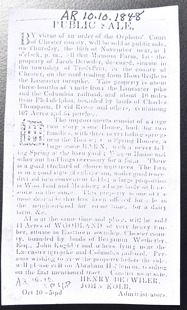
American Republican 1848-10-10 |
Henry & Catharine Detwiler |
Tredyffrin School district |
10/5/1863 |
71.5p |
$75 |
W6-201; Salem school tract |
Henry & Catherine Detwiler |
David Detwiler |
4/9/1870 |
118a 123p |
$11,000 |
X7-216 |
David Detwiler |
|
1883 |
104a |
|
Breou |
George Jacobs |
|
1883 |
107a 23a |
|
Breou |
David Detwiler |
|
1912 |
107a 25p |
|
Atlas |
|
|
T2-681 JACOB KURTZ & BARBARA, in to ABRAHAM KURTZ, dated 3-5-1801, recorded 11-19-1801 in T.2-43-681 for 3 tracts in Tredyffrin,-Tract #1. BEGINNING at a post near a hickory tree in line of John Maxwell, thence by same S27½°E 13.7 perches, S61¾°W 16.3 perches, a S28½°E 10 perches to Spanish oak, thence by other part of said tract S70°W 26 perches to post, and S28½°W 90½ perches to stake in line of John Bull; thence by same S62½°W 113 perches to stone; thence by John Showalter’s land N28½°W 98 perches to a post, and N42°E 6.9 perches to a walnut tree, N63½°E 23½ perches, N14¾°W 29 perches to middle of creek, and down the same N72½°E 26 perches to a beech; N57°E 5.4 perches to an ash; S70°E 17.9 perches to an ash, N15¾°E 14 perches to a poplar, S86¼°E 15.8 perches to a poplar, N62¾°E 55 perches to the place of beginning. Containing 85½ Acres, being part of premises last conveyed.
#2 Beginning at a post in a public road, and by land of Peter Grove, N50°W 47 perches to a heap of stones, and by land of Elijah Funk N32¾°E 17 perches to a marked Spanish oak, thence by other part of said tract S15°E 48.6 perches to a post in the aforesaid road, and along the same S37¾°W 17 perches to the place of beginning. 5a 15p
#3 Beginning at a stone in a public road and by the land of Philip Clare, N57°E 15 perches to a stone, and by other part of said tract, S26°E 68 perches to a post, and by land of John Maxwell S37°W 15 perches to a stone, and N26°W 63 perches to the place of beginning. 6a
Also privilege to use water of the Valley creek conveyed from the line of John Monday through other land of Jacob Kurtz five days in every week (he helping clean the water course, repair the dam for the same whenever necessary to the full amount of one-half the expense thereof) commencing Saturday morning, and also privilege to pass and repass along the present road near the house of said Jacob Kurtz with cart or wagon he being at one-half expense in keeping same in repair; also the right of said Jacob to take & convey the water from line of Joseph Showalter, through the land of John Munday, through the land of said Jacob at his own expense 5 days in every week hereafter (saving and reserving out of this grant unto the said Jacob Kurtz, his heirs and assigns forever, the privilege to pass and repass along present road on hereby granted premises with carts and wagons, and also privilege to pass through hereby granted premises north of the barn to the meadow of said Jacob to haul hay therefrom forever, he being at one-half expense in keeping said road in repair.
|
Table F.2.1 Salem ME Church tract
|
From |
To |
Date |
Area |
Cost |
Reference |
|
|
|
|
|
|
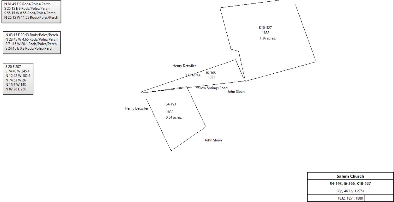
John Sloan et al |
Daniel & John McCurdy, Joseph Criley, Samuel Levis, William Few, James Hixon, William Umpleby, trustees |
7/5/1832 |
88p, (see deed O3-183) |
$1 |
S4-193 |
Henry & Catharine Detwiler |
Daniel & John McCurdy, John Sloan, Joseph & Charles Batt, Edward Schofield, Preston Ayras, James Brook, & John Dean, trustees of Salem ME Church |
3/21/1851 |
46.1p, part of 104a 16p (see deed C4-426) |
$28 80c |
I6-366 |
David & Annie Detwiler |
Salem ME Church |
6/7/1888 |
1.275a |
$100 |
K10-527 |
 |
|
|
Table F.3 St. Peter’s Church
|
From |
To |
Date |
Area |
Cost |
Reference |
|
|
|
|
|
|
Methusalot Davis |
William Moore et al |
5/6/1745 |
1a |
|
F-558 |
William Moore et al |
Trust of St. Peter’s Church |
5/10/1745 |
1a |
|
F-589 |
|
|
F-558 Deed. On 6 May 1745 Methusalot Davis of Trydriffrin, yeoman, to William Moore of Charlestown, Esq., Thomas James of Trydriffrin, yeoman, Morris Griffith of Willistown, yeoman, & Richard Richardson & John Cuthbert of Whiteland, yeomen. Methusalot Davis for 5 shillings grant to William Moore, Thomas James, Morris Griffith, Richard Richardson & John Cuthbert a tract in Trydriffrin bounded by a road called Rees Pritchard's Road & land of the Methusalot Davis. Description: beginning at a small black oak by the side of a road called Rees Pritchard’s Road thence south 88 degrees east by the land of the said Methussaleh Davis 8 perches to a stone, thence north 24 degrees west by the same land 20 perches to a post, thence north 88 degrees west by the same land 8 perches to a stone, thence south 24 degrees east by the said road 20 perches to the place of beginning containing one acre or thereabouts being part of 200 acres which John Penn, Thomas Penn & Richard Penn by their commissioner George Thomas, Esq., by deed dated 12 Apr last past, recorded in Philadelphia, Book A, Vol 11, Page 400, granted to Methusalot Davis. Signed Methusalot Davis. Delivered in the presence of William Hartley, George Aston & George Jarrnan. Recorded 24 June 1745.
F-589 Declaration of Intent. On 10 May 1745 William Moore, Esq., Thomas James, Morris Griffith, Richard Richardson & John Cuthbert all of Chester County, yeomen send greetings whereas Methusalot Davis by deed dated 6 May 1745 granted to William Moore, Thomas James, Morris Griffith, Richard Richardson & John Cuthbert a piece of land in Trydriffrin bounded by the road called Rees Pritchard's Road & land of Methusalot Davis containing 1 acre to be held in trust of the members of Saint Peter's Church for a church & burying ground. Signed William Moore, Thomas James, Morris Griffith, Richard Richardson & John Cuthbert. Delivered in the presence of William Harkey, George Aston & George James. Recorded 13 Sep 1745.
|
Table F.4 – St Peter’s Mill
|
From |
To |
Date |
Area |
Cost |
Reference |
|
|
|
|
|
|
|
Samuel Lilly |
1739 |
|
|
Fulling Mill, quoted in O2-518 (lease of ½ acre) – see Table F; no sign of sale or purchase deeds |
Samuel Lilly |
|
? |
100a |
|
Quit rent records |
Samuel Lilly |
|
1739 |
|
|
County tax |
Samuel Lilly |
|
1740 |
|
|
County tax; next tax list 1747 |
Samuel Lilly |
James Rowland |
|
|
|
No Lilly – Rowland deed found |
James Rowland |
|
1742/3 |
|
|
dies |
|
John Rowland |
1744 |
|
|
John Rowland wins court case and James Rowland’s will is declared null and void. John inherits James’ land including fulling mill |
John Rowland sr. |
Letitia Rowland |
4/4/1745 |
|
|
Will. I bequeth to my wife Letitia the property of 100a with fulling mill purchased from Samuel Lilly. Probate 4/30/1746 |
Letitia, John & William Rowland |
Thomas James |
9/1/1749 |
100a & fulling mill |
£100 |
G-492; Mortgage. See deed plan, bounded by land of James Rowland, Thomas David, Thomas Martin & Stephen David. Lettica Rowland, John Rowland & William Rowland to pay £100 plus interest in yearly payments to Thomas James, to be paid in full on or before 1 June 1752. Signed Lettica Rowland, John Rowland & William Rowland. Delivered in the presence of Ellis Davis, James Owens & John Evans. Recorded 12 Oct 1749. |
Letitia & John Rowland |
Thomas James of Tredyffrin |
10/15/1750 |
100a & fulling mill |
£150 |
H-80; Mortgage. Bounded by land of James Rowland, Thomas David, Thomas Martin & Stephen David, containing 100 acres. Lettice & John Rowland to pay £150 plus interest to Thomas James in full on 1 June 1752. Signed Lettice Rowland & John Rowland. Delivered in the presence of Isaac Davis, Ann Owen & Lewis James. Recorded 6 Mar 1750/1. |
Lewis James, attorney for Morris Bowen |
Thomas Hobbert, Thomas Martin & Thomas Lloyd |
6/26/(1750?)
Recorded 6/23/1751 |
|
|
H-167; discharge of real estate of James Rowland?? |
Letitia Rowland |
|
|
|
|
Not in tax record. No probate or administration. |
John Rowland |
|
1753 |
|
|
Miller (county tax) |
James & Israel Davis |
|
1758 |
|
|
Fulling mill, covenant M-77 by Jacob Davis |
James & Israel Davis |
|
? |
100a |
|
Quit rent records |
Israel Davis |
|
1760 |
|
|
Tax. Israel Davis fulling mill (& 125a); James Davis sr. 100a; James Davis jr. 350a |
James and Isaac Davis |
|
December 11, 1760 |
|
|
Pennsylvania Gazette: James and Isaac Davis asking for someone to lease their fulling mill, 30 acres of cleared land and 3 acres of meadow, dwelling house, barn & orchard for a term of 3 years. James & Israel? Davis are living in Tredyffrin, near the Valley church. |
James Davis |
|
1762 |
|
|
Tax; also entry for Jacob Davis |
James Davis, taylor |
|
1765 |
|
|
Tax, 100a & 50a with Fulling mill; Jacob Davis 35a, James Davis 350a, Israel Davis 90a |
James Davis |
|
1767 |
|
|
150a & Fulling mill; tax; Israel Davis 90a, James Davis 300a |
James & Elizabeth Davis & Israel (son) & Hannah Davis |
David Jones |
2/5/1767 |
|
|
Quoted in A2-280 |
Israel & Hannah Davis |
David Jones |
2/5/1767 |
9a 3r 30p (part of 133a, O-337 table F) |
£55 |
T-61, not fulling mill; see deed plan; also see table F |
Conrad Bradsman |
David Jones |
3/12/1767 |
109a 3r 30p? |
|
Quoted in A2-280. No purchase or sale deeds for Bradsman / Bratsman found. |
Conrad Bratsman |
|
1767 |
50a |
|
tax |
David & Lucy Jones |
John Showater |
4/3/1770 |
109a 3r 30p |
£790 |
A2-280; Jones, Fuller; Fulling mill |
 |
John Shoewalder |
|
6/21/1770 |
|
|
Advertisement in the Pennsylvania Gazette: A fulling mill to let situated on the road leading to the Yellow Springs, about 8 miles from the Swedes Ford, and 4 miles from the White Horse. |
John Showater |
|
1778 |
109a |
|
Tax, mill |
John Showater |
|
1779 |
100a |
|
Tax, mill |
John Showater |
|
1781 |
109a |
|
Tax, grist mill |
John Showater jr. |
|
1783 |
25a |
|
Tax, grist mill |
John Showater sr. |
|
1783 |
84a |
|
Tax |
John & Esther Showalter |
Jacob Gerber |
3/18/1785 |
28a 19p |
£1000 |
Z-90; Messuage, Water, corn or grist mill; see John Griffith tract for remainder of John Showalter’s tract |
Jacob Carver |
|
1785 |
28a |
|
Tax; grist mill |
Jacob Carver |
|
1786 |
28a |
|
Tax; grist mill |
Jacob & Mary Gerber |
Jacob Kurtz |
11/22/1791 |
28a 19p |
£1000 |
G2-263 |
Jacob & Barbara Kurtz |
John Francis |
1/15/1793 |
28a 19p |
£1000 |
D3-152; mentions buildings but not messuage |
John Francis |
|
1794 |
|
|
Mill on road plan |
John Francis |
|
1795 |
20a assessed |
|
Tax. Buildings, Grist Mill, Distillery, house; tenant Ephraim Buffington |
|
John Francis aka Jonah Frances |
1798 |
27a |
|
Glass Tax; occupied by William Jones. Log house 18’ x 15’, stone grist mill 25’ x 20’; stone stable 20’ x 15’;
See article by Roger Thorne on the Church Road Cabin |
John Showalter |
|
1798 |
81a (109 – 28) |
|
Glass tax; Log cabin 30’ x 25’, log barn 53’ x30’, log stable 24’ x 16’, stone spring house 12’ x 8’ |
John Showalter |
To son David plantation where I now live, estate to be divided among all children |
2/19/1803 (will); 2/15/1806 (probate) |
|
|
died; see John Griffith tract for continuation of David Showalter tract |
John Showater |
Conrad Acker |
4/1/1820 |
6a 146p (part of 9a 3r 30p) |
|
Y3 (71) – 152. See table F.3 (north) |
John Francis of Charlestown |
|
1809 |
|
|
Died. |
Henry Jenkins (executor for John Francis) |
William Reed, miller |
4/11/1810 |
|
£1000 1s |
D3-412. Messuage, grist mill. Sold by public sale in 1809 |
William & Phebe Reed |
Michael Gunkle |
9/6/1810 |
27a 114p |
£1150 |
E3-239; Messuage, Grist Mill & Plantation. Reed miller |
Michael & Catherine Gunkle |
John G. Bull & Abram Phillips |
4/9/1816 |
|
$6000 |
Q3-241; Gunkle miller. Messuage, plantation & grist mill |
Abram & Anne Phillips |
John G. Bull |
3/3/1824 |
½ moeity |
|
X3-480 |
John G. Bull |
William French |
4/5/1827 |
27a 114p |
|
B4-444 |
Conrad Acker |
John G. Bull |
4/9/1827 |
0.5 a |
|
B4-446; release of mill pond |
|
William French |
1830 |
|
|
Road deed |
William & Charlotte French |
David Christman |
3/29/1834 |
27a 114p & ½a |
$5000 |
I4-245; Messuage, Grist Mill, Saw Mill & other buildings |
|
David Chrisman |
1847 |
|
|
Sawmill. Chester County Atlas |
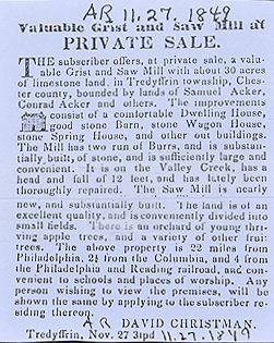
Similar advertisements appeared in 10/15/1850 and 10/26/1852. |
David & Mary Ann Chrisman |
George Pechin |
3/31/1853 |
27a 114p + 0.5a |
$6,900 |
T5-190 |
Jacob Heffelfinger, sheriff (writ of Samuel Acker against George Pechin) |
Henry Detwiler |
3/5/1860 |
27a 114p + 0.5a |
$3,850 |
R6-297 |
Henry & Catherine Detwiler |
George Fetters |
4/4/1868 |
27a 114p + 0.5a |
$5,700 |
P7-343; Grist & sawmill |
|
George Fetters |
1873 |
27a |
|
Grist & Sawmill; Witmer’s Atlas |
|
George Fetters |
1883 |
27a |
|
Grist & Sawmill; Breou’s Atlas |
George Fetters |
|
9/5/1891 |
27a |
|
died testate |
|
George Fetters’ estate |
1897 |
27a 2r 34p |
|
Atlas |
Samuel Fetters, executor of the will of George Fetters |
William H. and Della Smith |
10/5/1911 |
27 acres 114 perches + 0.5 acres |
$1,000 |
B14-197; Messuage, Grist Mill and Saw Mill |
|
Mrs. H. Smith |
1912 |
27a 2r 34p |
|
Franklin Atlas |
William H. and Della Smith |
Hugh Conroy |
11/1/1920 |
27a 2r 34p |
$1 |
W15-77 , Messuage, Grist Mill and Saw Mill (27.1 + 0.5 acres, deed ) |
Hugh & Mary Conroy |
Aaron R. Coleman |
2/26/1921 |
27 acres 114 perches + 0.5 acres, |
$2,000 |
W15-575 , Messuage, Grist Mill and Saw Mill |
Aaron R. Coleman |
Janet M. Brook |
10/26/1923 |
|
$2,000 |
K16-26 |
Fred V. and Janet M. Brook |
William Morris and Elizabeth D. Griscom |
2/6/1925 |
27.1 + 0.5 acres |
$1 |
S16-211 |
William M. and Elizabeth Griscom |
Andrew H. Kaye |
11/7/1927 |
27.1 + ? acres |
$1 |
N17-221 including Messuage, Grist Mill and Saw Mill |
Andrew H. Kaye |
Philadelphia Mainline Airport |
12/28/1928 |
57.288 acres + 8 acres 96 perches + 27.1 acres + 0.5 acres (mill pond), |
|
Y17-23 (H18-11 corrected company name) |
C. Wilfred and Elizabeth Cox Holland |
Philadelphia Main Line Airport |
1/30/1929 |
34a 7p + 10a |
$1 |
Y17-101; Tredyffrin; ; see John Griffith Patent for earlier history . |
William B. & Mary Y. Devaney |
E. Burke & Catharine Wilford |
2/27/1929 |
142.415a |
|
quoted in H18-10 |
E. Burke & Catharine Wilford |
Philadelphia Main Line Airport |
4/12/1929 |
142.415a |
$1 |
H18-10; East Whiteland |
Philadelphia Main Line Airport |
E. Burke Wilford |
1/31/1930 |
57.288 acres + 8 acres 96 perches + 27.1 acres + 0.5 acres (mill pond) + 34 acres 7 perches + 10a |
$1 |
P17-540 |
E. Burke & Catharine Wilford |
E. Burke & Catharine Wilford |
2/7/1931 |
57.288 acres + 8 acres 96 perches + 27.1 acres + 0.5 acres (mill pond) + 34 acres 7 perches + ? |
$50,000 mortgage from the Philadelphia Main Line Airport |
E18-306; added mortgage |
|
E. Burke Wilford |
1933 |
138a |
|
Chester County Atlas |
E. Burke & Catharine Wilford |
Kenneth and Elizabeth Sowden |
12/6/1943 |
8.537 a |
$2,500 |
Q21-5 |
Kenneth and Elizabeth Sowden |
George and Jean DeAddio |
9/2/1948 |
8.537a |
$3,700 |
X23-236 |
|
George DeAddio |
1950 |
8.537a |
|
Cabin property east of Church Road. Main line Atlas |
Beverly, George, and Jean DeAddio |
John G. Shea |
6/2/1986 |
101,581 ft2 |
|
307-367 |
John G. Shea |
Irrevocable trust of John G. Shea |
12/15/1988 |
101,581 ft2 |
|
413-452 |
John G. Shea |
Susan Tall |
2/14/2008 |
101,581 ft2 |
|
7366-514 |
Susan Tall |
Dean Mancinelli and Christina Yarold |
8/3/2017 |
101,581 ft2 |
|
9590-521 |
|
Table F.4.1
|
From |
To |
Date |
Area |
Cost |
Reference |
|
|
|
|
|
|
E. Burke & Catharine Wilford |
Benjamin A. & Eleanor S. Dickson |
7/3/1946 |
41.724a |
$26,000 |
R22-283 |
|
Benjamin A. Dickson |
1950 |
41.724a |
|
Mill property west of Church Road. Main line Atlas |
Bethlehem Limestone Company |
Benjamin A. & Eleanor S. Dickson |
5/15/1953 |
0.29a |
$1 |
R23-575; see table F.4.2 for earlier history |
Benjamin A. & Eleanor S. Dickson |
Homer & Alice Uhler |
10/19/1955 |
4.104a |
$5848 20c |
O27-56 |
Benjamin A. & Eleanor S. Dickson |
Henry R. & Margaret T. Darling |
8/1/1957 |
5.081a |
$27,250 |
M29-605 |
Benjamin A. & Eleanor S. Dickson |
Robert D. Narrigan |
10/3/1957 |
3.5a + 2.678a |
$9,000 |
Q29-286 |
Benjamin A. & Eleanor S. Dickson |
William G. & Margaret M. Borlase |
2/2/1959 |
2.572a |
$3,000 |
W30-249 |
Benjamin A. & Eleanor S. Dickson |
Robert R. Savarese |
7/20/1959 |
1000,000 ft2 |
$4.025 |
K31-14 |
Benjamin A. & Eleanor S. Dickson |
Robert Bruce Balbirnie |
9/11/1962 |
3.292a + 2.562a + 3.373a + 2.691a + 2.793a + 6.847a |
$28,500 |
O34-282 |
|
Table F.4.2
|
From |
To |
Date |
Area |
Cost |
Reference |
|
|
|
|
|
|
E. Burke & Catharine Wilford |
John J. & Marguerita Baranzano |
9/30/1941 |
20a |
$1 |
X20-94; from E18-306 above |
John J. & Marguerita Baranzano |
Joseph & Antonietta Baranzano |
3/3/1942 |
20a |
$1 |
B21-178 |
Joseph & Antonietta Baranzano |
John J. & Marguerita Baranzano |
6/24/1945 |
20a |
$1 |
C22-64 |
John J. & Marguerita Baranzano |
Ida M. McCoy |
4/9/1947 |
20a |
$20,000 |
Y22-161 |
Ida M. McCoy |
Edward J. Kenney |
4/15/1947 |
20a |
$1 |
Z22-169 |
Edward J. Kenney |
Bethlehem-Cuba Iron Mines Co. |
1/30/1950 |
20a |
$1 |
F24-334 |
George P. & Virginia B. Orr |
John C. Boyle |
4/24/1947 |
50a (Y17-178) + 3.08a (Q19-181) + 2.828a (E21-264) + 20a (R21-252) |
$1 |
U22-178 |
John C. Boyle |
Edward J. Kenney |
4/27/1947 |
50a + 3.08a + 2.828a |
$1 |
G22-355 |
E. Burke & Catharine Wilford |
Ida M. McCoy |
4/9/1947 |
? - 8a - 2a; + 57.288a + 8a 96p + 27.1a + 0.5a (mill pond) + 34a 7p + 10a - 2a - 4a - 8.537a - 20a - 41.724a |
$37,000 |
H22-224; see John Griffith Branch B and John Griffith AD.1 Branch B |
Ida M. McCoy |
Edward J. Kenney |
4/15/1947 |
? - 8a - 2a; + 57.288a + 8a 96p + 27.1a + 0.5a (mill pond) + 34a 7p + 10a - 2a - 4a - 8.537a - 20a - 41.724a |
$1 |
H22-284 |
Edward J. Kenney |
Bethlehem-Cuba Iron Mines Co. |
1/30/1950 |
? - 8a - 2a; + 57.288a + 8a 96p + 27.1a + 0.5a (mill pond) + 34a 7p + 10a - 2a - 4a - 8.537a - 20a - 41.724a |
$1 |
X22-302 |
Edward J.. Kenney |
Bethlehem-Cuba Iron Mines Co. |
1/30/1950 |
50a + 3.08a + 2.828a |
$1 |
X22-309 |
Bethlehem-Cuba Iron Mines Co. |
Monroe Coal Mining Co. |
9/20/1950 |
Not defined |
$10 |
X22-428 |
Bethlehem Limestone Company |
Benjamin A. & Eleanor S. Dickson |
5/15/1953 |
0.29a |
$1 |
R23-575; see table F.4.1 |
|
Table F.4.3 - Tredyffrin
|
From |
To |
Date |
Area |
Cost |
Reference |
|
|
|
|
|
|
Joseph E. Hickman |
Marple Corson |
4/1/1862 |
80a (East Whiteland) + 10a (Tredyffrin) + 4a 115p (Charlestown) |
$10,800 |
T6-48 |
Vincent G. Flynn, administrator of the estate of Marple Corson |
Joseph A. Malin |
3/30/1881 |
80a (East Whiteland) + 10a (Tredyffrin) + 25a 114p (East Whiteland) |
$14,779 64c |
K9-543 |
Catharine J. & Joseph Malin, administrators of the estate of Joseph A. Malin |
Robert W. Pechin |
1/26/1893 |
80a (East Whiteland) + 10a (Tredyffrin) + 25a 114p (East Whiteland) |
$13,092 21c |
B11-194 |
Robert W. Pechin |
|
4/9/1901 |
|
|
Died |
Henry L. Evans and William H. Walker, executors of the will of Robert W. Pechin |
Robert Hughes |
4/1/1905 |
80a (East Whiteland) + 10a (Tredyffrin) + 25a 114p (East Whiteland) |
$7,500 |
V12-391 |
Lewis W. and Ida May O'Donnell, executors of the will of Mansfield O'Donnell |
C. Wilfred Holland |
3/26/1906 |
34a 7p |
$5,310 |
E13-64 |
Robert and Naomi Chris Hughes |
C. Wilfred Holland |
3/29/1909 |
10a |
$1,200 |
Q13-328 |
C. Wilfred and Elizabeth Cox Holland |
Marshall J. Reynolds |
12/10/1925 |
34a 7p + 10a |
|
V16-517 |
|