Easttown Digital Archives
Mary A. Lewis Tract
Note: in these deed histories distances are quoted in perches (p) of length 16.5 feet. Areas are quoted in acres (a) and square perches (p). There are 160 square perches to an acre. In a few cases roods (a quarter of an acre) are also used.
For the earlier deed history see Wood(east) tract and Berwyn (post 1796)
West side of Berwyn
From |
To |
Date |
Area |
Cost |
Reference |
|
|
|
|
|
|
John Llewellyn & David & Elizabeth Llewellyn (wife) |
Ann Llewellyn |
1779 |
66.25a |
£2000? |
W-187 release; TEQ vol 1, #2 |
Ann Llewellyn |
James Brown |
1785 |
43a |
£165 |
A2-463 |
William Worthington, sheriff, debt of Samuel Enos Davis |
William Neill |
2/21/1800 |
6a |
£330 |
S2-378 |
Ann Llewellyn |
David Llewellyn |
4/18/1801 |
23a |
£100 |
T2-261; see table G, Berwyn post-1796 |
James Brown |
|
1788 |
43a |
|
Mortgage deed D4-94 |
James and Rachel Brown |
William Neill |
6/15/1805 |
29a 58p |
£242 8s 6d | A3-34 |
James Morris |
William Neill |
3/31/1813 |
18a 57p |
$1,500 |
I3-48 (see table G, Berwyn post-1796) |
William & Margaret Neill |
James Gamble |
4/1/1814 |
10a 50p |
$2,000 |
I3-409 (see table G, Berwyn post-1796). |
William Neill |
Executors wife, Margaret, William Walley, & Alexander Kennedy |
1820 |
|
|
Died; probate 1820 |
Execs. Of William Neill |
Ann Whittle |
4/1/1822 |
40a 2r 14p |
$2750 |
U3-242; parts of S2-378, A3-34, and I3-48; Tredyffrin & Easttown |
Ann Whittle |
William Hyde in trust for Ann Carter |
1822 |
40a 2r 14p |
|
Z3-163 |
Ann Cater |
|
1875 |
|
|
Died; probate |
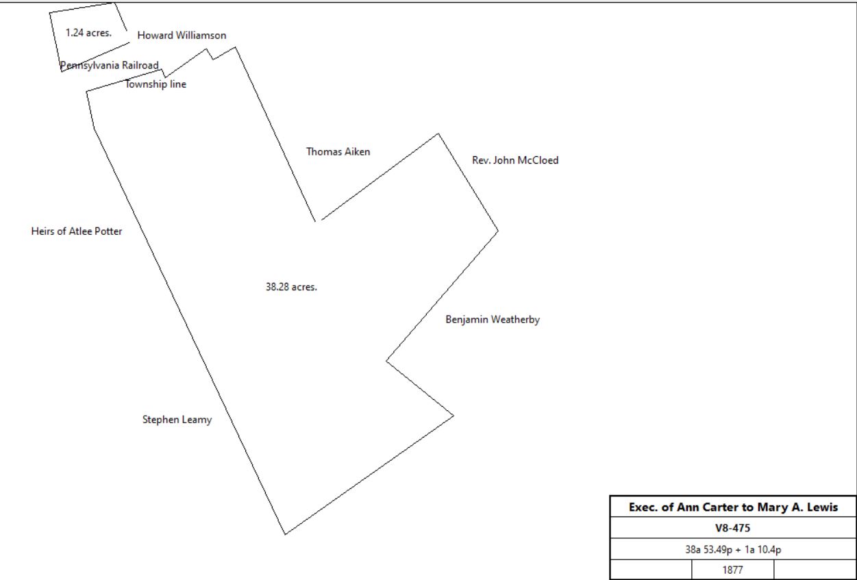
Exec of Ann Carter (William McClary) |
Mary A. Lewis |
2/28/1877 |
38a 53.49p + 1a 10.4p |
$3400 |
V8-475 |
| |||||
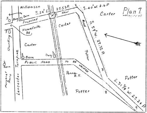
Exec of Ann Carter (William McClary) |
Pennsylvania Railroad |
3/31/1877 |
0.148a + 0.777a + 0.3a |
$2,800 |
X8-143 |
Enos & Mary Lewis |
Washington Baker |
2/18/1879 |
2a 110p |
$1,500 |
E9-5; see Table B for continuation |
Mary A. Lewis |
|
1883 |
|
|
Breou; west side of Bridge Avenue |
Reference: TEHS Quarterly 1-3 | |||||
Mary A. Lewis |
Charles Z. Jones |
2/4/1884 |
0.479a |
$500 |
S9-424; see Table A below |
Mary A. Lewis |
Mary R. Kauffman |
5/31/1887 |
5.757a |
$5,757 |
E10-585 Area encompassing Walnut & Central Avenues; Sub-division Plan (2.22 Mb) |
John & Mary Kauffman |
William B. Nuzum |
6/1/1887 |
0.136a |
$193 |
E10-582; lot #6 |
John & Mary Kauffman |
W. Atlee & Sallie Potter |
6/1/1887 |
0.681a |
$875 |
E10-583 |
John & Mary Kauffman |
Robert Jones |
6/1/1887 |
0.278a |
$378 50c |
E10-584 |
John & Mary Kauffman |
W. Atlee Potter |
6/1/1887 |
0.681a |
$875 |
E10-588; lots #36, 37, 38, 39, 40; see W. A. Potter tract for continuation |
J. Comley Hall, trustree of John & Mary Kauffman |
Sarah Hoskins |
12/15/1899 |
0.22a |
$350 |
A12-399 |
Sarah Hoskins |
George Aman |
2/10/1903 |
9,537ft2 |
|
L12-225 |
|
|
|
|
|
|
Mary Ann Lewis |
|
1888 (probate) |
|
|
died |
Table A | |||||
From |
To |
Date |
Area |
Cost |
Reference |
|
|
|
|
|
|
Charles Z. & Ida Jones |
Richardson B. Okie |
4/19/1886 |
0.472a |
$600 |
E10-11; see deed S9-424 for earlier history |
Richardson B. & Mary Okie |
Harry Hardy |
4/21/1886 |
0.239a |
$300 |
E10-12 |
Harry & Mary Hardy |
Emma Ivester |
8/30/1886 |
0.239a |
$335 |
E10-162 |
Emma Megonegal (nee Ivester) |
Mary Jane Sharp, sister |
2/11/1920 |
died intestate |
|
died intestate |
| |||||
Mary Jane Sharp |
Annie Quigley |
8/31/1920 |
4917.5 ft2 |
$1 |
T15-424 |
Table B | |||||
From |
To |
Date |
Area |
Cost |
Reference |
|
|
|
|
|
|
Enos & Mary Lewis |
Washington Baker |
2/18/1879 |
2a 110p |
$1,500 |
E9-5 |
| |||||
Washington & Phebe Baker |
David Kaufman |
4/18/1885 |
0.361a |
$350 |
A10-279; no messuage |
Washington & Phebe Baker |
J. P. Lamborn |
7/24/1886 |
0.411a |
$400 |
F10-21; no messuage |
| |||||
David Kaufman |
Mary Kaufman, wife |
1/17/1900 |
|
|
died |
Mary Kaufman |
George Amman |
2/28/1903 |
0.361a |
$4,500 |
E12-271; buildings and improvements |
George & Annie Amman |
Manor Real Estate & Trust Co. |
2/28/1903 |
0.361a |
$4,500 |
X12-239 |
Manor Real Estate & Trust Co. |
Howard & Mazie Ross |
10/31/1924 |
0.361a |
$5,500 |
R16-121 |
Howard & Mazie Ross |
William & Ellen Rambo |
5/19/1927 |
0.361a |
$1 |
M17-147 |
William & Ellen Rambo |
Terry Lee & Miriam Gross Myers |
9/3/1968 |
0.361a |
$21,500 |
I38-1022 |
Terry Lee & Miriam Gross Myers |
Thomas & Nancy Jarrett |
2/28/1974 |
0.361a |
$32,500 |
X42-209 |
Thomas & Nancy Jarrett |
William & Pamela Hamilton |
8/5/1977 |
0.361a |
$44,500 |
M51-123 |
Pamela Hamilton |
John Murtagh and Linda Murtagh |
5/12/2000 |
0.361a |
$155,000 |
4757-2256 |
John Murtagh and Linda Murtagh (nka Linda Rafferty) |
Bison Head Partners |
5/30/2017 |
not stated |
$390,000 |
9551-2365 |
Bison Head Partners |
Dianna & Joseph Heideman |
3/1/2019 |
not stated |
|
9889-1376 |