Easttown Digital Archives
Berwyn 1796 onwards
Note: in these deed histories distances are quoted in perches (p) of length 16.5 feet. Areas are quoted in acres (a) and square perches (p). There are 160 square perches to an acre. In a few cases roods (a quarter of an acre) are also used.
See Table 4 Wood(east) for the earlier deed history of the Berwyn area.
1796 Status
From |
To |
Date |
Area |
Cost |
Reference |
|
|
|
|
|
|
|
1796 |
10a |
|
|
|
|
1796 |
32a 117p |
|
|
|
|
1796 |
22a 100p |
|
|
|
1796 |
23a |
|
|
||
|
1786 |
43a |
|
Alexander Templeton renting? |
|
|
1796 |
50a (2 tracts) |
|
County tax; William Reed renting |
|
|
1796 |
73a (2 tracts) |
|
County Tax; Stone house, Dwelling House, Log Barn |
|
|
1796 |
11a |
|
Exact location of this tract unknown at present; Additional 72a next to Waynesborough |
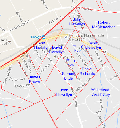
Berwyn Land Ownership in 1796
Table A - Daniel Richards Tract
From |
To |
Date |
Area |
Cost |
Reference |
|
|
|
|
|
|
Daniel Richards |
|
1796 |
10a |
|
|
Daniel Richards |
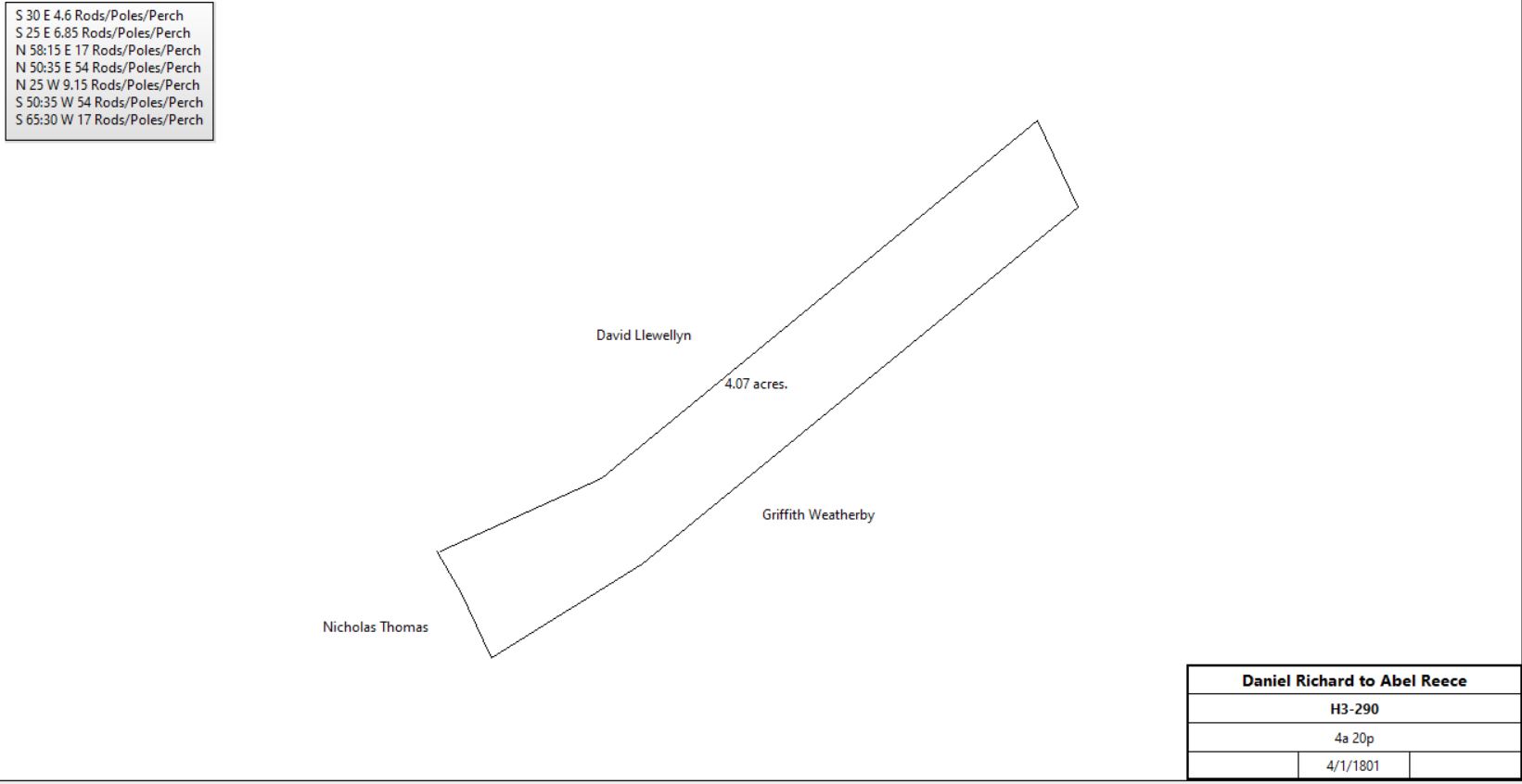
Abel Reece |
4/1/1801 |
4a 20p |
£59 16s |
H3-290 |
 | |||||
Abel Reece / Reese |
Benjamin Weatherby |
4/2/1813 |
4a 20p |
|
H3-291 |
Table B - Henry Fox Tract
From |
To |
Date |
Area |
Cost |
Reference |
|
|
|
|
|
|
Henry Fox |
|
1796 |
11a |
|
|
Henry & Mary Fox |
Samuel King |
4/15/1797 |
|
|
P2-238 |
Samuel & Catharine King |
Jacob Detwiler |
F5-350 |
|||
Jacob Detwiler |
died |
||||
John Kolb &Henry Detwiler (admin. of Jacob Detwiler) |
Peter Burn & Mifflin Lewis | 1849 |
$1,540 |
H5-605 |
|
Peter and Elizabeth Burn & Mifflin and Eliza C. Lewis |
John Kugler |
1854 |
A6-247 |
Table C - James Brown Tract
From |
To |
Date |
Area |
Cost |
Reference |
|
|
|
|
|
|
James Brown |
|
1796 |
43a |
|
|
James Brown |
William Neil |
1805 |
29a 58p |
|
A3-34 |
See Mary A. Lewis tract for further details. | |||||
Table D - Torbet-Kugler Tract
From |
To |
Date |
Area |
Cost |
Reference |
|
|
|
|
|
|
Samuel & Margaret Bittle |
John Llewellyn |
2/7/1797 |
4a |
£36 |
T2-40 |
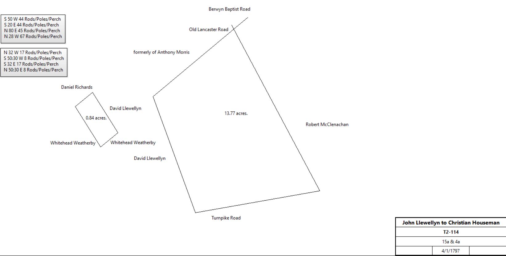
John & Ann Llewellyn |
Christian Houseman |
4/1/1797 |
15a & 4a |
£445 |
T2-114; Fox Inn (see Henry Fox and the Fox Inn in Easttown) |
 | |||||
Henry & Mary Ruth |
David Llewellyn |
1801 |
9a |
|
T2-523 |
Christian Houseman |
William Neil |
3/29/1802 |
|
£431 |
W2-19 |
David Llewellyn |
William Torbet |
1804 |
4 tracts: 35 acres (see Table 4.1 Wood(east)), 9 acres (see above), 34 3/4 acres (see Table 4.1 Wood(east)), and 23 acres (see Aiken tract) |
£2200 |
Y2-176 |
| |||||
William Neil |
Elizabeth McCullough |
1804 |
|
|
Y2-131 |
William Neil |
William Torbet |
1806 |
14a 60p |
|
B3-140 |
Jesse John, Sheriff (property of Elizabeth McCullough) |
William Torbet |
1807 |
|
|
C3-20 |
William & Jane Torbet |
John Smith |
1808 |
2a |
$600 |
B3-455 |
John & Ann Smith |
Mordecai Moore |
1811 |
|
|
G3-26 |
William Torbet |
|
1812 |
|
|
Died intestate leaving widow and 6 children. Land awarded to Alexander Torbet |
Mordecai & Sarah Moore |
Evan Roberts |
1813 |
2a + 17a 115p |
|
H3-250; for disposition see Joseph Williams tract |
Alexander & Elizabeth Torbet |
John Kugler |
1814 |
100.75a |
|
I3-489 |
John Kugler jr. |
John Kugler sr. |
5/7/1820 |
100.45a |
|
R3-434; Tredyffrin & Easttown |
.jpg) | |||||
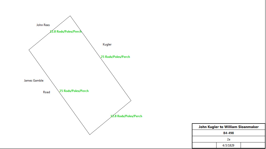
John and Mary Kugler of Tredyffrin |
William Sloanaker |
4/3/1829 |
2a |
$400 |
B4-498; Easttown and Tredyffrin; see Local titles in Easttown and Tredyffrin : Article VI : The Stephen D. Hunter tract, TEQ vol 3, #2 |
| |||||
William Sloanaker of Easttown |
Griffith Weatherby et al |
1830 |
|
|
C4-526 |
William and Eliza B. Sloanaker |
Abes Beaumont of Radnor |
3/31/1836 |
2a |
$1810 |
M4-4 |
Emmor Beaumont |
Stephen D. Hunter |
4/1/1842 |
2a |
$250 |
W4-31; Messuage or tenement store house |
Stephen D. & Elizabeth Hunter |
Joseph C. Smith |
4/8/1848 |
105p |
$700 |
F5-539; messuage |
Stephen D. & Elizabeth Hunter |
James Brooke |
1/28/1879 |
1a 55p |
$2,500 |
A9-188; frame tenement or store house |
James Brooke |
Frank Stauffer |
10/13/1879 |
1a 55p |
$2,500 |
E9-16; frame tenement or store house |
Frank & Etta Stauffer |
Pennsylvania Railroad |
5/1/1880 |
0.313a |
$100 |
G9-478 |
|
|
|
|
|
|
Benjamin & Valentine Kugler (execs of John Kugler) |
Samuel B. Thomas |
3/29/1845 |
97.75a |
$1543 75c |
E5-444; Easttown & Tredyffrin |
Samuel B. Thomas |
Benjamin Kugler |
3/29/1845 |
97.75a |
$1543 75c |
E5-443 |
Benjamin & Susanna Kugler |
John Kugler |
3/27/1847 |
66a 66p |
$55 |
G5-242 |
John & Hannah Kugler |
Thomas Matthews |
4/1/1859 |
17a 2r 17.5p |
$1,584 84c |
K6-480; see John Frick tract for continuation |
John & Hannah Kugler |
Pennsylvania Rail Road Company |
8/12/1859 |
1a 3p |
$150 |
L6-397; station tract |
John Kugler |
John McLoed |
3/9/1861 |
59a 3r 7.8p |
$5,082 90c |
O6-567 |
John & Elizabeth McLoed |
William Clark |
9/13/1862 |
9a 1r 8.7p - 15,000ft2 |
$1,000 |
T6-478; see table D.8 |
John McLoed |
Henry Fritz |
8/4/1866 |
1.75a 22p |
$2,000 |
C7-287; Fritz Lumber tract; see table D.9 |
John & Elizabeth McLoed |
Charles Clark |
2/3/1870 |
1a 8.5p |
$500 |
Y7-37; see table D.8 |
John & Elizabeth McLoed |
Martha Stetson |
8/31/1871 |
54p |
$2,300 |
B8-223 |
John & Elizabeth McLeod |
Henry Freeman |
10/31/1874 |
1a 23.6p |
$1 |
O8-136; see table D.1 below for continuation |
John & Elizabeth McLeod |
Mary R. Kauffman |
7/1/1878 |
41.7p |
$1 |
A9-42; see table D.10 below for continuation |
John McLoed |
George Tobler |
12/7/1882 |
1.4a |
$1,500 |
M9-498 |
Rev. John McLoed |
|
1883 |
46a 2r 30p |
|
Breou’s Atlas |
Table D.1 | |||||
From |
To |
Date |
Area |
Cost |
Reference |
|
|
|
|
|
|
|
|
|
|
|
|
John & Elizabeth McLeod |
Henry Freeman |
10/31/1874 |
1a 23.6p |
$1 |
O8-136 |
Henry & Susan Freeman |
John Simes |
10/6/1875 |
|
$7,500 |
S8-103 |
John & Matilda Simes |
John Freeman |
12/9/1875 |
|
$9,000 |
S8-148 |
Henry & Susan Freeman |
S. Jones Garber |
7/3/1876 |
|
$6,500 |
V8-207 |
S. Jones & Sarah Garber |
George Tobler |
6/4/1879 |
|
$7,000 |
D9-214 |
Table D.2 | |||||
From |
To |
Date |
Area |
Cost |
Reference |
|
|
|
|
|
|
John & Elizabeth McLoed |
Isaac Cleaver |
5/2/1872 |
148.5p |
$1,000 |
C8-262 |
Cleaver house and store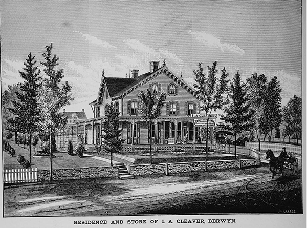 | |||||
| I. A. Cleaver house & store, Lancaster Avenue | |||||
Table D.3 | |||||
From |
To |
Date |
Area |
Cost |
Reference |
|
|
|
|
|
|
John & Elizabeth McLeod |
Henry Freeman |
10/31/1874 |
1a 23.6p |
$1 |
O8-136 |
Henry & Susan Freeman |
Samuel Jones Garber |
5/16/1877 |
113p |
$500 |
W8-317 |
Samuel Jones Garber |
Isaac Cleaver |
1/2/1878 |
113p |
|
Y8-193 |
Table D.4 | |||||
From |
To |
Date |
Area |
Cost |
Reference |
|
|
|
|
|
|
Annie Wertz |
Isaac Cleaver |
5/30/1887 |
(2a 75.6p - 0.25a) + 0.722a + 0.272a + 0.384a + 0.21a |
$1 |
I10-178 |
Table D.5 | |||||
From |
To |
Date |
Area |
Cost |
Reference |
|
|
|
|
|
|
Samuel Kromer, assignee of the goods of Henry Harrison |
Isaac Cleaver |
5/15/1889 |
0.108a |
$2,525 |
N10-423 |
Table D.6 | |||||
From |
To |
Date |
Area |
Cost |
Reference |
|
|
|
|
|
|
Joseph Sharp |
Isaac Cleaver |
7/8/1888 |
0.227 |
$2,200 |
L10-61 |
Table D.7 | |||||
From |
To |
Date |
Area |
Cost |
Reference |
|
|
|
|
|
|
Joseph Sharp |
Isaac Cleaver |
7/8/1888 |
0.264 |
$2,000 |
L10-118 |
Table D.8 - Between Waterloo & Main Avenues | |||||
From |
To |
Date |
Area |
Cost |
Reference |
|
|
|
|
|
|
John & Elizabeth McLoed |
William Clark |
9/13/1862 |
9a 1r 8.7p - 15,000ft2 |
$1,000 |
T6-478; see table D for earlier history |
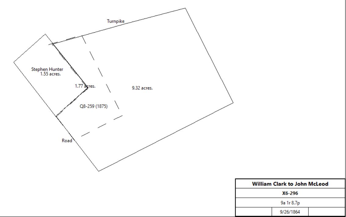
William Clark |
John McLoed |
9/26/1864 |
9a 1r 8.7p - 15,000ft2 (Trinity Church) |
$4,000 |
X6-296 |
John & Elizabeth McLoed |
Eliza Clark |
1/17/1866 |
1a 3r 6.92p |
$2,500 |
A7-399; buildings, no messuage |
William & Eliza Clark |
Charles Thompson |
3/16/1867 |
1a 3r 6.92p |
$2,500 |
E7-398 |
Charles & Margaret Thompson |
J. Morton Thompson |
2/25/1869 |
1a 3r 6.92p |
$3,000 |
R7-45 |
J. Morton Thompson |
Margaret Thompson |
2/26/1869 |
1a 3r 6.92p |
$3,000 |
R7-44 |
William Clark |
|
1873 |
|
|
Witmer’s atlas |
Margaret Thompson |
J. Morton Thompson |
5/22/1875 |
1a 3r 6.92p |
$5,500 |
Q8-259 |
 | |||||
J. Morton Thompson |
Dr. Theodore L. Adams |
5/9/1883 |
0.22a |
$450 |
S9-148 |
J. M. Thompson |
|
1883 |
|
|
Breou’s atlas |
Dr. T. Adams |
|
1883 |
|
|
Breou’s atlas |
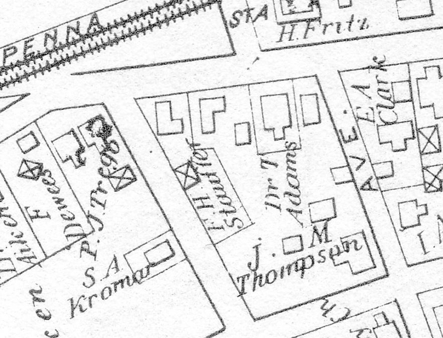 | |||||
Breou’s atlas, 1883 | |||||
Table D.9 - Fritz Lumber | |||||
From |
To |
Date |
Area |
Cost |
Reference |
|
|
|
|
|
|
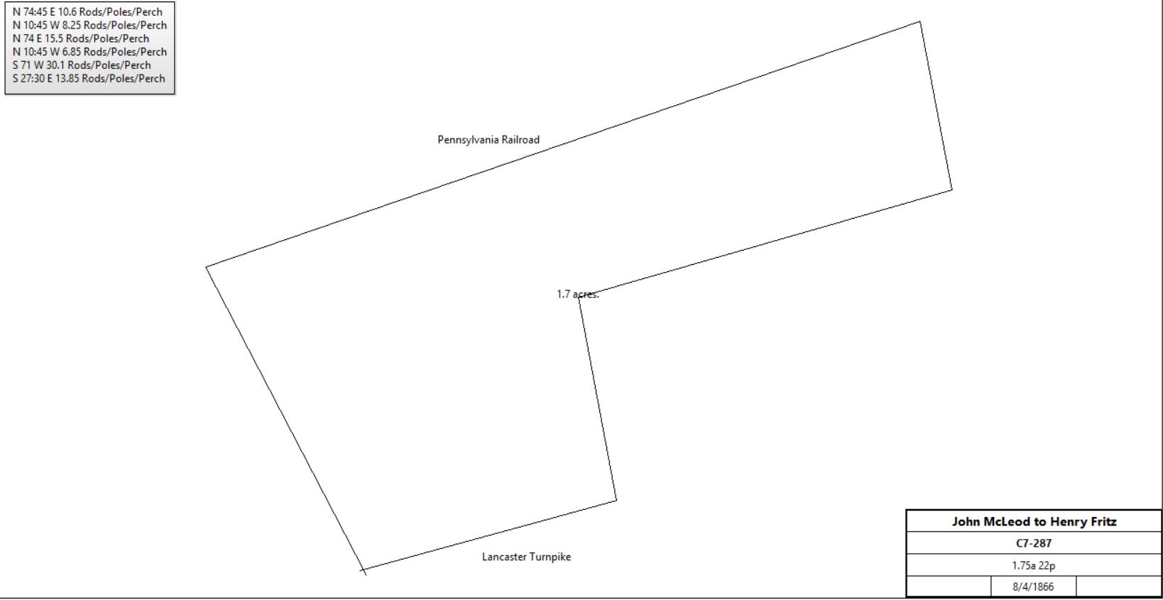
John McLoed |
Henry Fritz |
8/4/1866 |
1.75a 22p |
$2,000 |
C7-287; Fritz Lumber tract |
| |||||
Henry Fritz |
John Maurice Lewis |
4/2/1867 |
Lot 55' x 135' |
$1,000 |
H7-94; See The Maurice Lewis House |
Henry Fritz |
|
1870 |
|
|
Died |
Hugh Steen, guardian of the estates of William and Henry Fritz, minor children, & Mary Steen (previously Fritz) |
Pennsylvania Railroad Company |
10/28/1878 |
0.628a - 0.364 |
$600 + $1 |
C9-164 |
Hugh and Mary (previously Fritz) Steen & Henry Fritz |
William H. Fritz |
6/3/1892 |
1.043a |
$6,000 |
Y10-534 |
Table D.10 | |||||
From |
To |
Date |
Area |
Cost |
Reference |
|
|
|
|
|
|
John & Elizabeth McLeod |
Mary R. Kauffman |
7/1/1878 |
41.7p |
$1 |
A9-42 |
Mary R. Kauffman |
Pusey Pernack |
5/20/1889 |
41.7p |
$2,000 |
W10-104 |
Pusey & Ann Pernack |
Henry O. Garber |
4/16/1894 |
41.7p |
$3,000 |
D11-452 |
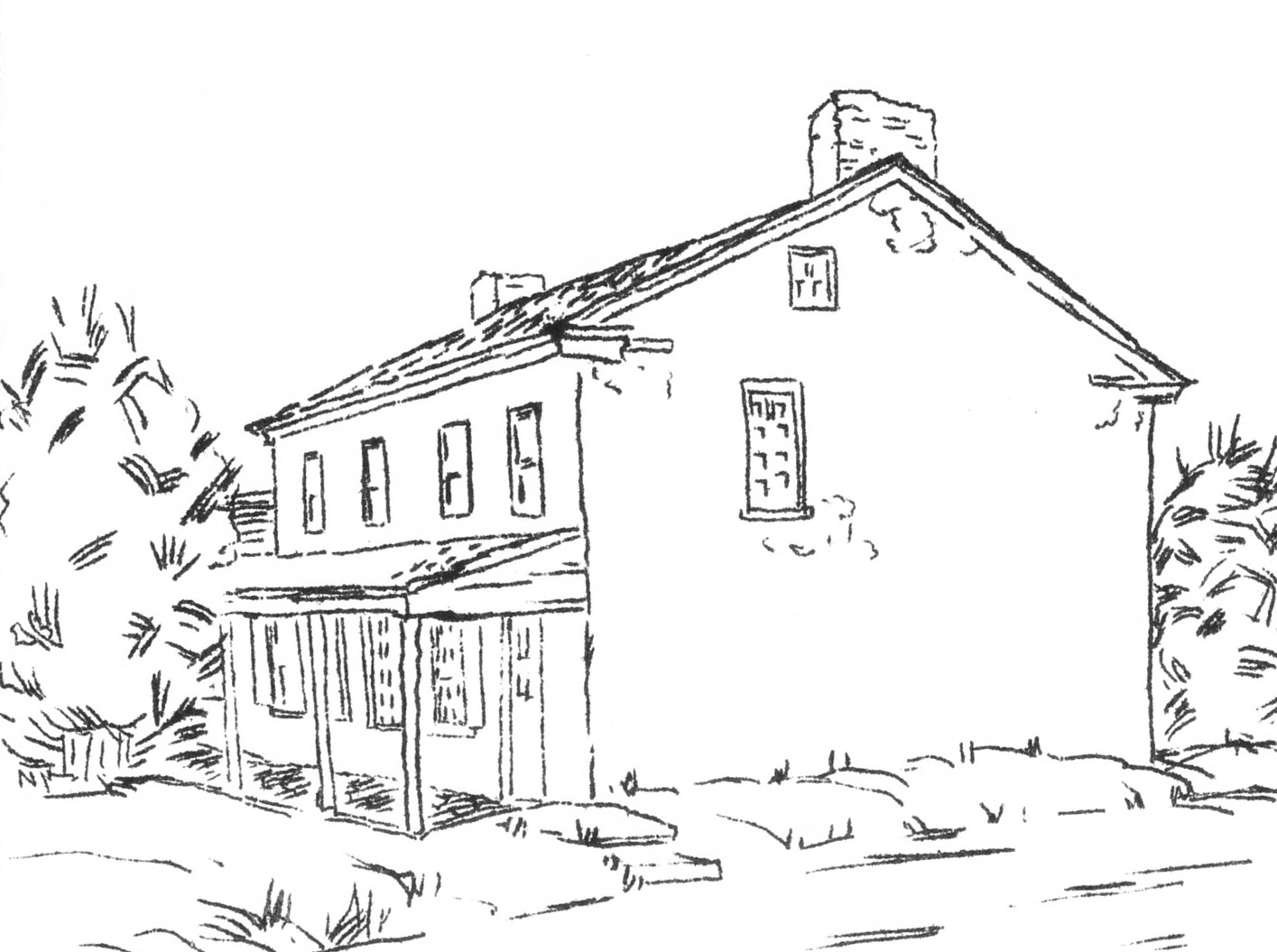
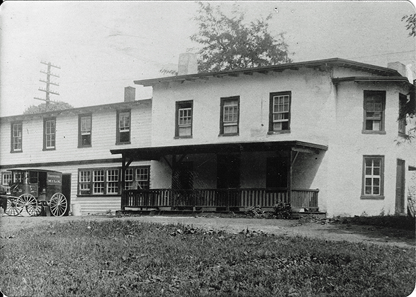
Table E - Henry Ruth Tract
From |
To |
Date |
Area |
Cost |
Reference |
|
|
|
|
|
|
Henry Ruth |
David & Jacob Ruth & Barbara Ruth Coffman |
1823 |
|
|
Died; administration & partition into 3 parts. #2 David Ruth |
David & Jacob Ruth |
Barbara Coffman |
5/22/1824 |
32a |
$1000 |
X3-44 No Coffman sale deed found in Chester County |
Table F - Samuel Bittle Tract
From |
To |
Date |
Area |
Cost |
Reference |
|
|
|
|
|
|
Samuel Bittle |
|
1796 |
22a 100p |
|
|
Samuel & Margaret Bittle |
John Llewellyn |
2/7/1797 |
4a |
£36 |
T2-40; see Torbet-Kugler tract |
Samuel & Margaret Bittle |
Whitehead Weatherby |
2/22/1797 |
18a 100p |
£95 |
P2-30 |
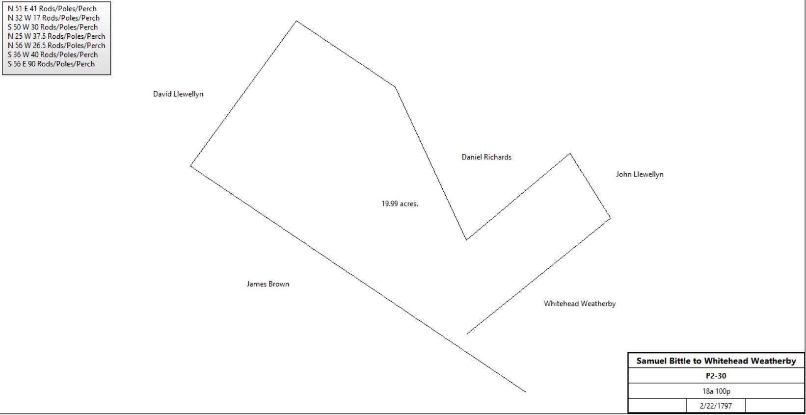 | |||||
Table G - Aiken Tract
From |
To |
Date |
Area |
Cost |
Reference |
|
|
|
|
|
|
Ann Llewellyn |
|
1796 |
23a |
|
|
Ann Llewellyn |
David Llewellyn |
4/18/1801 |
23a |
£100 |
T2-261 |
David Llewellyn |
Alexander Templeton |
1801 |
18a 57p |
|
V2-243 |
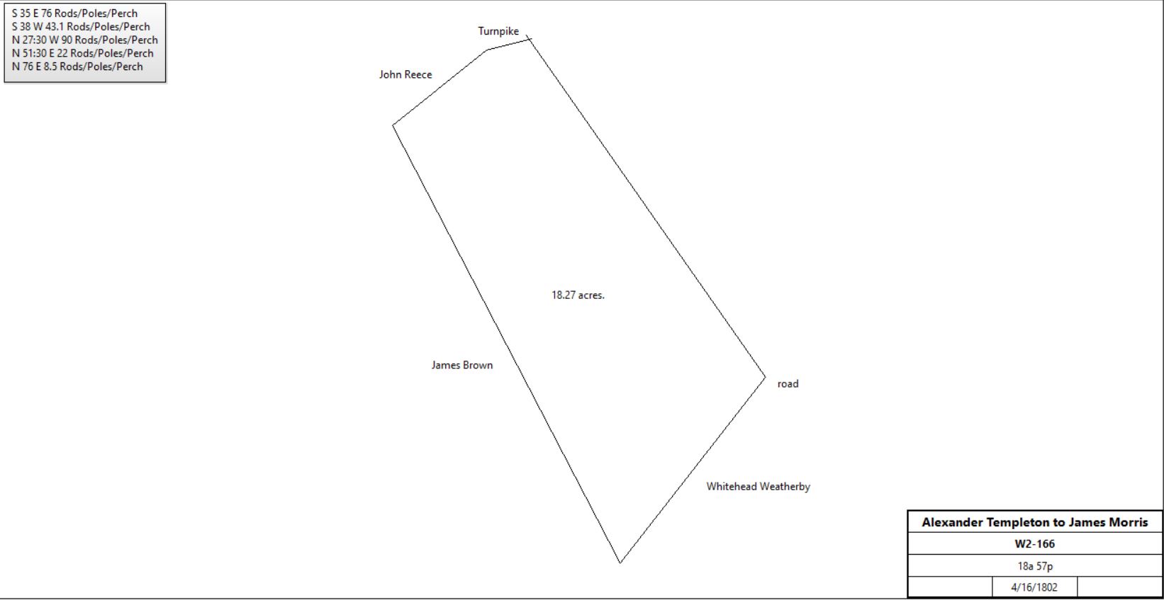
Alexander & Ann Templeton |
James Morris |
4/16/1802 |
18a 57p |
£110 |
W2-166 |
 | |||||
James Morris |
William Neill |
1813 |
18a 57p |
$1,500 |
I3-48 |
William & Margaret Neill |
James Gamble |
4/1/1814 |
10a 50p |
|
I3-409 |
Peter Osborne, Sheriff (premises of James Gamble) |
William Gamble |
1833 |
10a |
$1970 |
H4-81 |
Sheriff (premises of William Gamble) |
Samuel White |
|
10a 52p |
|
D6-206; messuage two tenements |
Samuel White |
Thomas Aiken |
1870 |
10a 126p |
$6150 |
U7-267 |
.jpg) | |||||
Aiken |
|
1883 |
|
|
Breou |
Thomas Aiken |
Thomas J. Aiken, Claire Aiken (wife of James Aiken), and Mary J. Wells |
8/15/1896 |
2.386a + 0.842a + 0.481a + 0.374a + 0.115a + 0.109a + 0.386a + 0.186a + 0.082a |
|
R11-199; Sub-division Plan (2.85 Mb) |
Clara A. Aiken estate |
|
July 1925 |
|
|
Sub-division Plan (1.87 Mb) |
Table G.1 | |||||
From |
To |
Date |
Area |
Cost |
Reference |
|
|
|
|
|
|
|
|
|
|
|
|
Thomas Aiken |
Charles Weaver |
11/17/1886 |
0.094a |
$1,700 |
E10-581, part of U7-267 |
Charles Weaver & wife |
Henry O. Garber |
3/30/1893 |
0.094a |
$2,600 |
C11-366 |
|
|
|
|
|
|
|
|
|
|
|
|
Thomas J. Aiken & wife |
Henry O. Garber |
9/17/1898 |
0.082a |
$1,500 |
V11-406; tract #9 in R11-199 |
|
|
|
|
|
|
Henry O. Garber, widower |
Edna Garber Burns and Elizabeth G. Pyle (daughters) |
4/21/1934 |
0.094a + 0.082a |
$1 |
I21-118; 2 messuages; Reserving the right of occupancy |
Raymond & Edna Garber Burns |
Elizabeth G. Pyle |
10/30/1943 |
½ part of 0.094a + 0.082a |
$4,000 |
Q21-31 |
Table G.2 Alleva tract | |||||
From |
To |
Date |
Area |
Cost |
Reference |
|
|
|
|
|
|
Thomas Aiken |
|
|
|
|
|
Peter J. Trego |
|
1883 - 1894 |
Lot & buildings |
|
Taxes |
Margaret Jennie Trego |
|
1895 - 1900 |
Lot & buildings |
|
Taxes (no 1901 taxes available) |
|
|
|
|
|
|
Edna Creeley |
Karl & Anna Lichtenfeld |
6/28/1940 |
|
|
H20-167; incorrect, quoted in D52-345 |
Samuel Lichtenfeld, executor of the will of Anna Lichtenfeld |
Louis J. & Mary L. Alleva |
11/30/1977 |
0.235a |
$25,500 |
D52-345 |
Mary L. Alleva |
Eadah Family Limited Partnership |
4/29/2004 |
0.235a |
$135,000 |
B6152-1660 |
Table G.3 Henry Garber tracts | |||||
From |
To |
Date |
Area |
Cost |
Reference |
|
|
|
|
|
|
Thomas Aiken |
Henry O. Garber |
10/10/1889 |
0.114a |
$320 |
S10-238; part of U7-267 |
Thomas Aiken |
Phenes Garber |
10/10/1889 |
0.114a |
$320 |
S10-241; part of U7-267 |
Thomas Aiken |
Henry O. Garber |
6/25/1891 |
0.131a |
$368 |
Y10-85 |
|
|
|
|
|
|
Thomas Aiken |
Charles Weaver |
11/17/1886 |
0.094a |
$1,700 |
E10-581 |
Charles & Ella Weaver |
Henry O. Garber |
3/30/1893 |
0.094a |
$2,600 |
C11-366 |
|
|
|
|
|
|
Frederick Pile, trustee |
Lindley, Ida, & Humbolt Garber of Philadelphia |
6/5/1886 |
Lot on Spring Garden Street + 4a 25p + woodlot (both in Tredyffrin) |
|
L11-24 |
Pusey & Ann Pernack |
Henry O. Garber |
4/16/1894 |
41.7p |
$3,000 |
D11-452; see table D.10 |
|
|
|
|
|
|
Thomas Aiken |
John Dunn |
3/12/1885 |
0.082a |
$1,500 |
A10-315 |
John & Elizabeth Dunn |
Thomas Aiken |
2/16/1892 |
0.082a |
$1,500 |
I11-78 |
Thomas Aiken |
Thomas J. Aiken, Claire Aiken (wife of James Aiken), and Mary J. Wells |
8/15/1896 |
0.082a |
|
R11-199; see above, part of a larger tract |
Thomas & Susan Aiken, Claire Aiken (wife of James Aiken), and Mary J. Wells |
Henry O. Garber |
9/17/1898 |
0.082a |
$1,500 |
V11-406 |
|
|
|
|
|
|
Table H - John Keller Tract
From |
To |
Date |
Area |
Cost |
Reference |
|
|
|
|
|
|
David Ryan |
John Keller |
4/1/1881 |
|
|
L9-208 |
John & Elizabeth Keller |
William H. Fritz |
8/31/1886 |
0.788a |
$1,000 |
L10-27 |
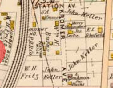
Fritz & Keller properties shown in 1897 atlas; north to the right |
Table I - Preston Lobb House
From |
To |
Date |
Area |
Cost |
Reference |
|
|
|
|
|
|
John & Eliza McLeod |
Preston Lobb |
11/13/1877 |
1a 32p |
$900 |
Y8-248 |
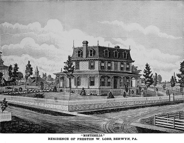 | |||||
Preston Lobb house, Berwyn and Woodside Avenues, demolished 1988 | |||||
References from the Quarterly
- Local Titles in Easttown and Tredyffrin Article I: Mary A. Lewis Tract, 1877 Part A
- Chronicles of Old Cockletown in Tredyffrin and Easttown, in ye goodly province of Pennsylvania
- Local titles in Easttown and Tredyffrin: Article I (continued): Mary A. Lewis Tract, 1877 Part B
- Local titles in Easttown and Tredyffrin: Article II : Thomas Aiken Tract, 1870
- Local Titles in Easttown and Tredyffrin Article III: Two Old Taverns in Easttown The Fox, part of Joseph Williams tract; The Spring House (George Washington), Reverend John McLeod tract. Part A
- Local Titles in Easttown and Tredyffrin Article III: Two Old Taverns in Easttown The Fox, part of Joseph Williams tract; The Spring House (George Washington), Reverend John McLeod tract. Part A (continued)
- The Fox and Springhouse Taverns Part B.
- Local Titles in Easttown and Tredyffrin Article V: The Joseph C. Smith Tract, Plan of 250 acre tract
- Local titles in Easttown and Tredyffrin : Article VI : The Stephen D. Hunter tract
- Travelgwyn
- Local titles in Easttown and Tredyffrin : Article VII : The Reeseville Station tract
- The story of the Glassley Commons
- The early history of Berwyn
- Berwyn in the pre-Revolutionary and centennial periods
- Reminiscences of a shady road and quiet nook in Easttown