Willistown
Deeds
Note: in these deed histories distances are quoted in perches (p) of length 16.5 feet. Areas are quoted in acres (a) and square perches (p). There are 160 square perches to an acre. In a few cases roods (a quarter of an acre) are also used.
This a list of miscellaneous deeds chains in Willistown produced as part of various projects.
24 Lloyd Avenue
From |
To |
Date |
Area |
Cost |
Reference |
|
|
|
|
|
|
|
|
|
|
|
|
Benajmin & Mary Roberts |
Anna Maria Esler, wife of John Esler |
5/19/1864 |
56a 45p - 1a |
$4,000 |
W6-523 |
John Esler |
|
1873 |
|
|
Witmer’s atlas |
J. M. Mole |
|
1883 |
13a 7p (perhaps 73a) |
|
Breou’s atlas; no purchase deed found. Sheriff's deed? Mole was a builder |
Davis & Margaret Gill |
Lewis Brooke |
6/22/1886 |
65.81a |
$25,000 |
D10-192; this deed is endorsed by Julius Sachse, j. p. |
Lewis & Emma Brooke |
Gerhard Newhaus |
8/24/1888 |
|
$470 |
M10-182; lots 91 and 99; no mention of any buildings |
William R. Nicholson |
|
1912 |
76a |
|
atlas; disregard? |
Paoli Manor |
|
1933 |
|
|
atlas |
|
|
|
|
|
Q21-5 - incorrect reference |
Leslie Mateer, executor of the will of Gerhard Newhaus |
Kurtz & Elizabeth Shank |
7/1/1941 |
not quoted |
$3,500 |
I20-196; lots 91, 99, and 92 |
Kurtz & Elizabeth Shank |
Arthur & Miriam Shank |
10/7/1953 |
not quoted |
$1,125 |
T25-149; lot #99 |
Arthur & Miriam Shank |
Samuel & Elizabeth Barker |
1/16/1959 |
9.850 ft2 (lot #99) + part of lot #98 |
|
G31-337 |
Samuel & Elizabeth Barker |
John & Sue Cox |
9/14/1959 |
14,144 ft2 |
$2,200 |
Y31-55; lot #99 and part of #98 (see Q21-5), tract only |
John & Sue Cox |
Robert & Carolyn Hovaneitz |
4/17/1969 |
not quoted |
$24,000 |
T38-370 |
Robert & Carolyn Hovaneitz |
Gus & Peggy Costa |
5/28/1971 |
not quoted |
$22,000 |
Y39-31 |
Gus & Peggy Costa |
David & Elsie Hart |
1/15/1974 |
not quoted |
$52,000 |
R42-165 |
David & Elsie Hart |
Richard & Delores Fetterman |
6/6/1977 |
(0.3511a from GIS app) |
$62,500 |
C51-293 |
Richard & Delores Fetterman |
Richard & Delores Fetterman |
2/16/1984 |
not quoted |
$1 |
Y62-438 |
33 Lloyd Avenue
From |
To |
Date |
Area |
Cost |
Reference |
|
|
|
|
|
|
Samuel Powell |
daughter-to-be, Sarah Potts nee Powell |
9/19/1747 (will) |
|
|
died |
Joseph & Sarah Potts |
Thomas Davis |
2/3/1770 |
33a 77p |
£146 9s 5d |
W2-220 |
Thomas Davis |
Sidney Davis, sister |
11/17/1773 (will) |
|
|
died; tract |
Sidney Davis |
Elizabeth Wayne, daughter |
|
|
|
died intestate |
Isaac & Elizabeth Wayne |
Benjamin Hoopes |
3/24/1841 |
33a 44p |
$2,662 |
D5-585 |
Benjamin & Jane Hoopes |
Samuel W. Evans |
11/28/1856 |
26¾a |
$1,605 |
Z6-58 |
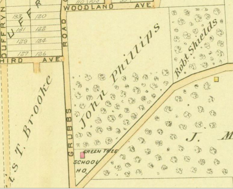
Samuel W. & Rebecca Evans |
John Lewis Phillips |
3/25/1868 |
26¾a |
$2,477 |
P7-289 |
John Lewis Phillips |
1/22/1875 |
|
|
|
died intestate leaving wife Elizabeth Phillips and 2 daughters, Clara Shields and Elizabeth Hardee |
| |||||
Elizabeth Phillips and husband Charles Stewart |
Clara Shields and Elizabeth Hardee |
7/19/1905 |
|
|
A13-131; release of dower right |
Clara Shields, widow |
Elizabeth Hardee |
10/23/1905 |
½ part of 26¾a |
|
Y12-15 |
Theodore & Bessie Hardee |
Pennsylvania Railroad Company |
2/14/1906 |
6.124a |
$3,115 78c |
A13-246 |
Elizabeth & Theodore Hardee |
Annie Wertz Miller |
8/27/1921 |
26¾a - 6.124a |
$1 |
Z15-213 |
Annie Wertz & William Bigler Miller |
John Frazer |
9/28/1922 |
9.065a |
$2,000 |
D16-117; tract only |
Henry & Lizzie Davis |
John Frazer |
|
|
|
Quoted in V16-431, not found |
John & Margaret Frazer |
Henry Davis |
7/22/1925 |
11,000 ft2 |
$1 |
V16-431 |
Henry & Lizzie Davis |
Elmer Lilley |
9/8/1925 |
11,000 ft2 |
$1 |
V16-104 |
Howard Green, sheriff |
Sears, Roebuck & Co. |
2/5/1931 |
11,000 ft2 |
$100 |
Q16-319 |
Sears, Roebuck & Co. |
Charles & Neta Spellman |
10/13/1933 |
11,000 ft2 |
$1 |
L18-297 |
Charles & Neta Spellman |
Elwood Spellman |
11/26/1941 |
11,000 ft2 |
$1 and mortgage of $2,800 |
N19-290 |
Elwood Spellman |
Charles & Neta Spellman |
11/28/1941 |
11,000 ft2 |
$1 and mortgage of $2,800 |
X21-265 |
Charles & Neta Spellman |
Ray & Bernice Williams |
12/12/1946 |
11,000 ft2 |
$1 |
C23-7 |
Ray Williams |
William & Shirley Pinkstone |
4/29/1963 |
11,000 ft2 + 2,271 ft2 |
$16,500 |
D35-162 |
William & Shirley Pinkstone |
Jonathan & Betty Myers |
4/20/1972 |
11,000 ft2 + 2,271 ft2 |
$32,000 |
O40-276 |
Jonathan & Betty Myers |
Betty Myers |
11/8/1978 |
11,000 ft2 + 2,271 ft2 |
$1 |
S54-152 |
Betty Myers |
Barton & Denise Van Valkenburgh |
8/25/1980 |
11,000 ft2 + 2,271 ft2 |
$69,400 |
G57-52 |
Davis & Margaret Gill
From |
To |
Date |
Area |
Cost |
Reference |
|
|
|
|
|
|
Thomas & Mary Trilliver |
George King |
12/29/1761 |
|
|
purchase deed not found; quoted in Y2-149 |
George & Katharine King |
Joseph Williams |
2/1/1762 |
158a |
£100 |
M-282; mortgage; messuage & plantation |
George King |
|
1792 (probate date) |
|
|
died testate |
Abraham King & Daniel Cornog |
George & Samuel King, sons of George King |
3/27/1797 |
93a 80p |
£1,200 |
Y2-149 |
Samson Babb, Sheriff, debt of George & Joseph King |
Abram Phillips |
8/1/1820 |
85a |
$2,000 |
Sheriff’s deed 2-189; messuage, planation and tract of land; neighbors Isaac Wayne, Roberts Roberts, George King et al |
Abram & Ann Phillips |
Henry Coffman |
8/21/1820 |
85a 125p |
$6,433 59c |
R3-455 |
Henry & Catharine Cauffman |
Jonathan Jones |
3/31/1832 |
85a 125p |
$9,000 |
E4-442; Green Tree tavern |
James & Eliza King |
Jonathan Jones |
7/7/1841 |
10a |
$550 |
U4 - 223 |
John G. & Sarah Bull |
Jonathan Jones |
4/4/1834 |
4a 21p |
$268 53c |
I4 - 200 |
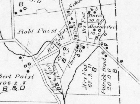
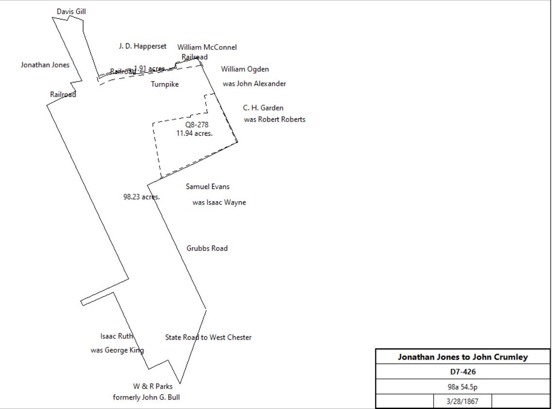
Jonathan Jones |
John Crumley |
3/28/1867 |
98a 54.5p |
$15,000 |
D7-426; Green Tree Tavern |
| |||||
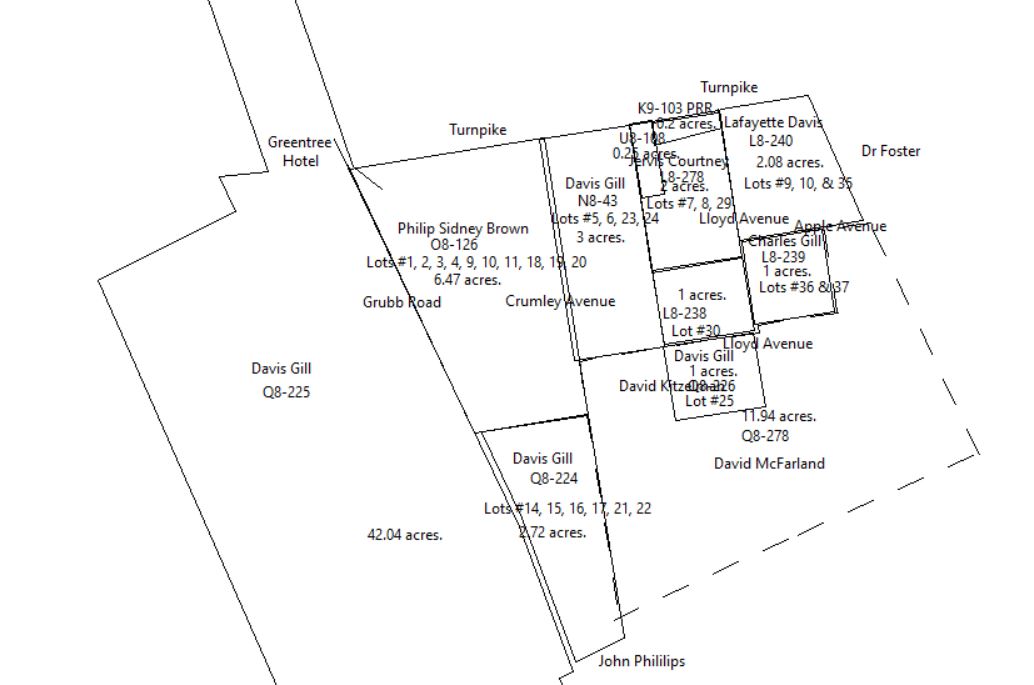
John & Cornelia Crumley |
Davis Gill |
3/31/1874 |
22a 84p + 121p |
$2,910 16c |
N8-42 |
John & Cornelia Crumley |
Davis Gill |
3/31/1874 |
3a |
$825 |
N8-43 |
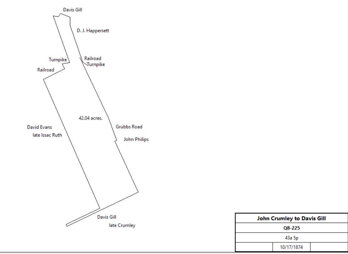
John & Cornelia Crumley |
Davis Gill |
10/17/1874 |
43a 5p |
$3,500 |
Q8-225; Greentree Hotel tract |
| |||||
John & Cornelia Crumley |
Davis Gill |
12/16/1874 |
2a 130p |
$450 |
Q8-224; lots #14, 15, 16, 17, 21, 22 |
John & Cornelia Crumley |
John McFarland |
6/5/1875 |
11a 82p + 1a 148p |
$1,000 |
Q8-278 |
John & Mary McFarland |
Davis Gill |
6/5/1875 |
11a 82p + 1a 148p |
$1,200 |
Q8 - 279 |
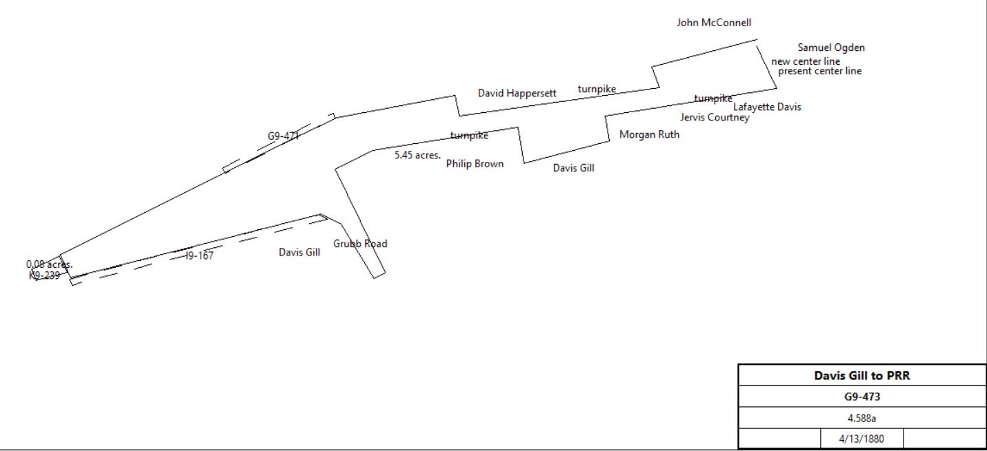
Davis & Margaret Gill |
PRR |
4/13/1880 |
4.588a |
$6,150 |
G9-473 |
| |||||
Davis & Margaret Gill |
Pennsylvania Railroad |
3/21/1881 |
0.266a |
$89 |
I9-167 |
Jervis Courtney
From |
To |
Date |
Area |
Cost |
Reference |
|
|
|
|
|
|
John & Cornelia Crumley |
Jervis Courtney |
|
2a |
|
L8-278; lots 7,8, 29 |
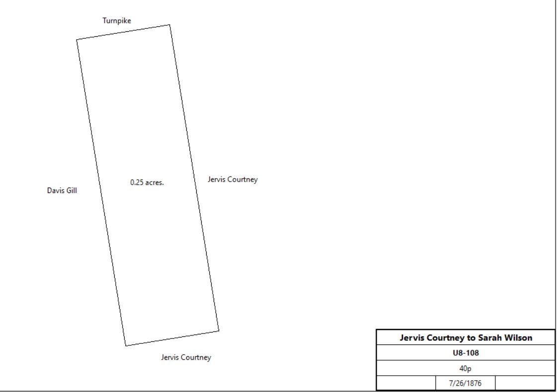
Jervis Courtney |
Sarah Wilson |
7/26/1876 |
40p |
$77 50c |
U8-108 |
| |||||
Sarah Wilson |
H. Morgan Ruth |
8/3/1878 |
40p |
$900 |
Z8-303 |
H. Morgan & Annie Ruth |
PRR |
4/7/1881 |
0.25a |
$1,100 |
L9-56; PRR lot #11 |
Jervis Courtney |
PRR |
7/24/1880 |
0.184a |
$90 |
K9-103; PRR lot #10 |
|
Davis Kitzelman | |||||
From |
To |
Date |
Area |
Cost |
Reference |
|
|
|
|
|
|
John & Cornelia Crumley |
Davis Kitzelman |
3/31/1874 |
1a |
$250 |
L8-238; lot #30 |
|
Lafayette Davis | |||||
From |
To |
Date |
Area |
Cost |
Reference |
|
|
|
|
|
|
John & Cornelia Crumley |
Lafayette Davis |
3/31/1874 |
2a 14p |
$541 |
L8-240; lots #9, 10, 35 |
|
Charles Gill | |||||
From |
To |
Date |
Area |
Cost |
Reference |
|
|
|
|
|
|
John & Cornelia Crumley |
Charles Gill |
3/31/1874 |
|
$174 |
L8-239; lots #36 and 37 |
| |||||
|
David Happersett | |||||
From |
To |
Date |
Area |
Cost |
Reference |
|
|
|
|
|
|
Jonathan Jones |
David Happersett |
3/27/1856 |
17a 142p |
$2,146 50c |
C6-76 |
David & Christianna Happersett |
Francis Cook |
7/17/1883 |
17a 142p |
$1 |
T9-252 |
|
Agnes Phillips | |||||
From |
To |
Date |
Area |
Cost |
Reference |
|
|
|
|
|
|
Henry Coffman |
Jonathan Jones |
3/30/1832 |
1a 32p |
|
E4-442? |
Jonathan Jones |
David Happersett |
3/27/1856 |
5/7th part of 12a 25p + 25p |
$2,146 50c |
C5-236 |
Jonathan Jones |
David Happersett |
3/27/1856 |
2/7th part of 12a 25p + 25p |
$2,146 50c |
C5-237 |
John L. Phillips |
|
1873 |
|
|
Witmer’s atlas |
|
Joseph King House | |||||
From |
To |
Date |
Area |
Cost |
Reference |
|
|
|
|
|
|
Samson Babb, Sheriff, debt of Joseph King and John Aikin |
Joshua Evans & Abram Phillips |
8/2/1820 |
50a |
$670 |
Sheriff’s deed 2-191; messuage, planation and tract of land; neighbors George King, John Batholomew, John G. Bull et al |
Abraham Phillips of Tredyffrin |
|
1841 |
|
|
died intestate |
Clinton Frame, Sheriff, debt of John L. Phillips (interest in) |
Joshua Evans |
5/9/1844 |
11a |
$31 |
Sheriff’s deed 5-152; messuage, store house, and tract of land |
Joshua Evans |
Jonathan Jones |
1/7/1845 |
7/12 part of 11a |
$1,383 75c |
C5-236; messuage, store house, and tract of land; neighbors Richard Richison, Amos Davis et al |
Ann Phillips (widow of Abram Phillips), Mary Ann Bartholomew (nee Phillips), Hannah, Eliza, Louisa, & Slater Phillips |
Jonathan Jones |
2/22/1845 |
Widow’ s dower one undivided moiety or half part and undivided 5/12ths |
$1,333 30c |
C5-237; messuage, store house, and tract of land; |
Jonathan Jones |
Agnes Phillips, daughter |
6/17/1851 |
12a 25p + 25p + 1a 38p |
$1 |
Z5-320 |
| |||||
Agnes Phillips |
|
1864 or 3/10/1866 (see deed U11-274) |
|
|
died; one child, Clara Shields |
Jonathan Jones |
|
1867 |
|
|
died |
Clara Philillips |
John L. Phillips |
1/28/1874 |
0.5a |
$50 |
K8-425 |
John L. Phillips |
|
1/27/1875 |
|
|
died |
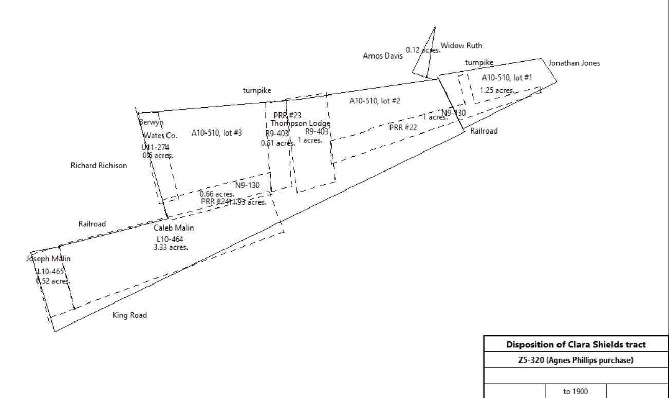
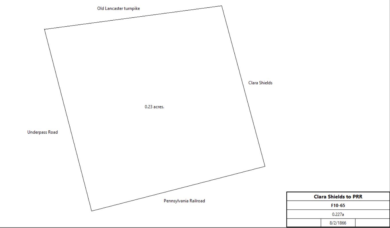
Clara Shields |
Pennsylvania Railroad |
7/2/1881 |
1.089a + 0.578a + 0.23a |
|
N9-130 |
Robert & Clara Shields |
Pennsylvania Railroad |
8/2/1886 |
0.227a |
$300 |
F10-65 |
| |||||
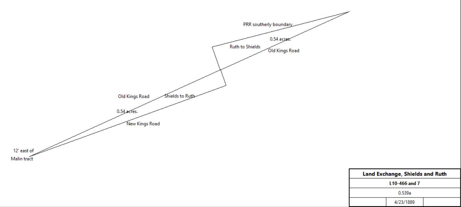
Robert & Clara Shields |
Gideon Rush |
4/23/1889 |
0.539a |
$500 |
L10-466 |
Gideon & A. Clara Rush |
Clara Shields |
4/23/1889 |
0.539a |
$500 |
L10-467 |
| |||||
Robert & Clara Shields |
Caleb Malin |
5/17/1889 |
3.33a |
$2,664 |
L10-464 |
Robert & Clara Shields |
Joseph Malin |
5/17/1889 |
0.529a |
$500 |
L10-465 |
Robert Shields |
|
1895 |
|
|
died |
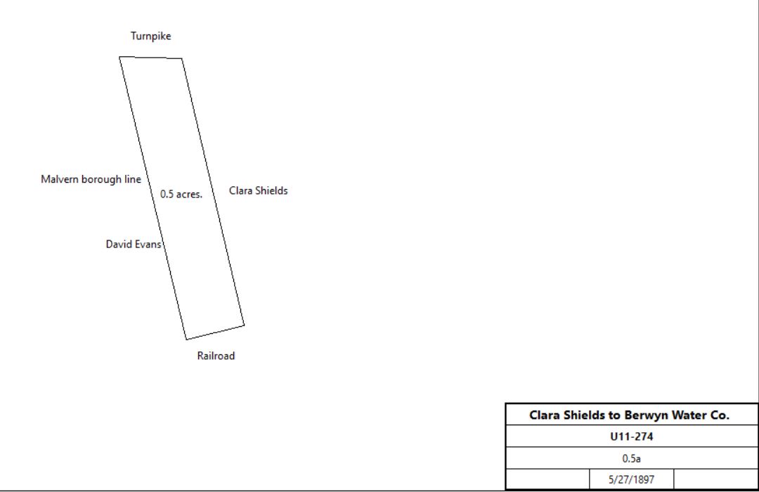
Clara Shields |
The Berwyn Water Co. |
5/27/1897 |
0.5a |
$500 |
U11-274 |
| |||||
William Turner, Sheriff, debt of Clara Shields |
Anna Hughes |
8/23/1900 |
0.5a + 2a + 3a |
$1 |
A12-510 |
John & Anna Hughes |
Richard Rennard |
4/21/1904 |
24,500ft2 |
$400 |
R12-111 |
Anna & John Hughes |
Andrew Purcell |
10/2/1905 |
not stated |
$410 |
Z12-531 |
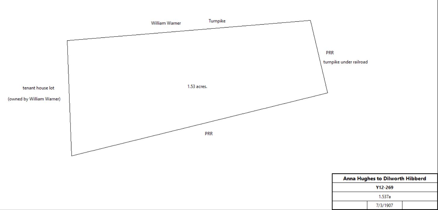
John & Anna Hughes |
Dilworth Hibberd |
7/3/1907 |
1.527a |
$1 |
Y12-269 |
| |||||
Anna & John Hughes |
Daniel Moran |
2/18/1914 |
0.5a |
$1 |
N14-299 |
|
|
|
|
|
|
Abraham Goldstein |
Norma L. & Richard W. Mercer |
1/24/1962 |
|
|
V33-344; #42 lot 2 CT 28010 ft2 |
Norma L. & Richard W. Mercer |
Elmer E. & Evelyn Griffith |
7/16/1964 |
|
|
W35-422; #42 lot 2 CT 28010 ft2 |
Elmer E. & Evelyn Griffith |
Robert C. & Linda S. Seltzer |
8/27/1980 |
|
|
F57-54; #42 |
|
|
|
|
|
|
|
|
|
|
|
|
|
House | |||||
From |
To |
Date |
Area |
Cost |
Reference |
|
|
|
|
|
|
Uriah & Mary Pennypacker |
Joseph Morgan |
3/28/1844 |
|
|
deed not found; quoted in F5-213 |
Joseph & Thamazin Morgan |
Isaac Ruth |
6//23/1847 |
2a 2p |
$73 |
F5-213 |
Isaac & Julianna Ruth |
Benajmin Roberts |
3/28/1848 |
2a 2p |
$374 |
G5-380; messuage |
|
David Evans | |||||
From |
To |
Date |
Area |
Cost |
Reference |
|
|
|
|
|
|
James B. Wood, sheriff, estate of Mordecai Thomas |
Abraham Bruner |
7/29/1847 |
25a |
$1,700 |
Sheriffs deed 5-253; neighbors Richard Dempsey, John Hutchinson et al |
Abraham & Rebecca Bruner |
Benjamin Roberts |
4/8/1848 |
22a 137.8p |
$1,600 |
G5-378 |
Isaac & Julianna Ruth |
Benajmin Roberts |
3/28/1848 |
2a 2p |
$374 |
G5-380; messuage; from above |
Benjamin & Mary Roberts |
David Evans |
3/29/1866 |
22a 137.8p |
$6,000 |
D7-120 |
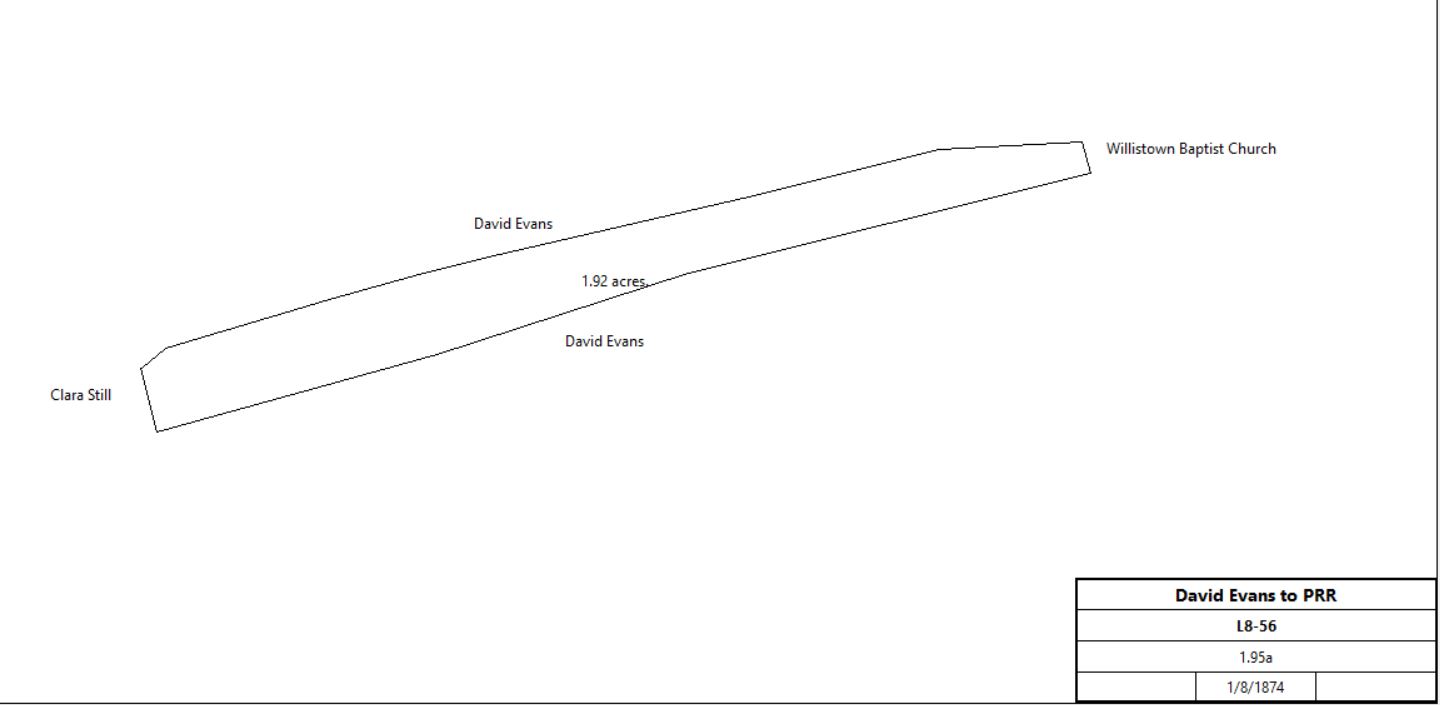
David & Eliza Evans |
Pennsylvania Railroad |
1/8/1874 |
1.95a |
$2,000 |
L8-56; PRR plan sheet #17 |
| |||||
David Evans |
Samuel Entriken |
3/30/1882 |
17,330 ft2 |
$2,000 |
M9-222; messuage |
Elmer E. & Evelyn Griffith |
Robert C. & Linda S. Seltzer |
8/27/1980 |
|
|
R9-421 |
|
Thompson Lodge | |||||
From |
To |
Date |
Area |
Cost |
Reference |
|
|
|
|
|
|
|
|
|
|
|
|
Rachel & Ann Davis |
Edmund Evans |
5/2/1865 |
1a |
$5,250 |
Z6-307 |
Edmund & Emma Evans |
John Lewis Phillips |
3/29/1871 |
1a |
$5,000 |
Y7-299 |
Clara Philillips |
John L. Phillips |
1/28/1874 |
0.5a |
$50 |
K8-425 |
John L. Phillips |
|
1/27/1875 |
|
|
died |
Thomas Smedley, administrator of the estate of John Lewis Phillips |
G. W. Gunkle, John Hoskins, Davis Gill, trustees of the Thompson Lodge |
4/13/1877 |
1.5a |
$4,000 |
X8-180 |
Trustees of Thompson Lodge |
Pennsylvania Railroad |
3/31/1882 |
1a + 0.5a |
$1,450 |
R9-403 |
|
Philip S. Brown | |||||
From |
To |
Date |
Area |
Cost |
Reference |
|
|
|
|
|
|
|
|
|
|
|
|
John & Cornelia Crumley |
Philip Brown |
11/4/1874 |
6.5a |
$1,412 50c |
O8-126; plots #1 -4, #11 - 13, #18 - 20 |
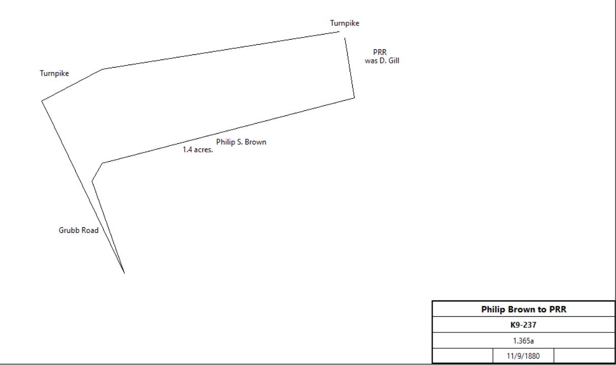
Philip S. & Natalie Brown |
Pennsylvania Railroad |
11/9/1880 |
1.365a |
$682 |
K9-237; PRR plan sheet #14 |
| |||||
|
Catherine Still | |||||
From |
To |
Date |
Area |
Cost |
Reference |
|
|
|
|
|
|
|
|
|
|
|
S6-299 |
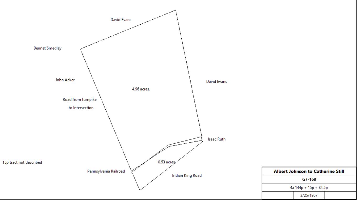
Albert & Mary Ann Johnson |
Catharine Still |
3/25/1867 |
4a 144p + 15p + 84.5p |
$3,500 |
G7-168 |
| |||||
Charles & Catherine Still |
Sallie Still |
12/17/1879 |
35p |
$250 |
I9-17 |
Catherine & Charles Still |
J. Jones Still |
2/11/1878 |
13,200ft2 |
$300 |
Z8-23 |
|
|
|
|
|
|
Charles Still, Levi John & Annie Still, George M. & Caroline Davis, George Still, Samuel & Irene Still, Mary & Emma Still heirs of Catherine Still |
Pennsylvania Railroad |
9/5/1887 |
0.071a + 0.017a |
$800 |
H10-387 |
|
Rock Hill Farm | |||||
From |
To |
Date |
Area |
Cost |
Reference |
|
|
|
|
|
|
William Penn |
Samuel Jobson |
110/17-18/1681 |
1,000a |
|
Lease and release |
William Markham & John Penn |
Samuel Jobson |
7/9/1687 |
1,000a |
|
Patent A-196 |
Samuel Jobson |
Michael Jobson, son |
2/3/1699 |
1,000a |
|
Phila. B2-314 |
Michael Jobson |
Samuel & Michael Jobson, sons |
10/1709 |
equally divided |
|
Will |
Samuel Jobson |
Thomas Smedley |
4/5-6/1726 |
one half part of 1,000a |
£240 |
Lease and release, see deed G-1 |
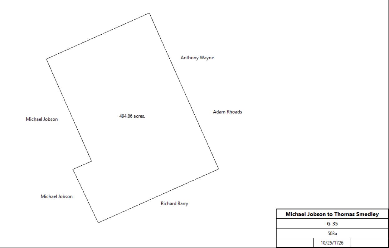
Michael Jobson |
Thomas Smedley |
10/25/1726 |
503a |
5s |
G-35 release; division of 1,000 acres |
| |||||
Michael Jobson |
Thomas Smedley |
12/30/1729 |
0.25a |
20s |
P2-377 |
Thomas and Sarah Smedley |
George Smedley |
5/16-17/1726 |
250a |
|
Lease and release |
George & Mary Smedley |
Joshua Smedley, son |
9/1750 |
95a |
5s |
O-471 |
Joshua Smedley |
Hannah, wife of Benjamin Cox and then her son George |
1812 (probate) |
|
|
inheritance. |
Benjamin Cox |
|
5/23/1818 (administration) |
|
|
died intestate |
George Cox |
|
6/1834 |
|
|
died |
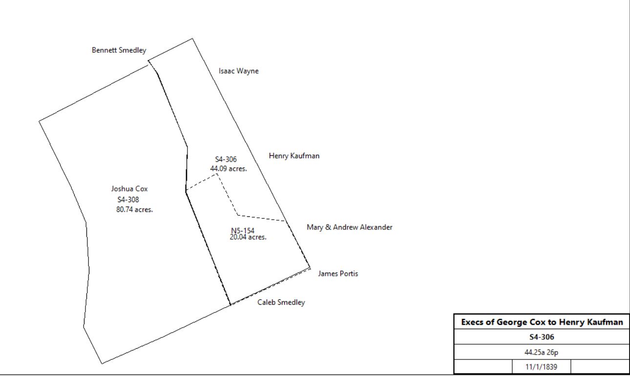
Levi Garrett & Thomas Massey, executors of the will of George Cox |
Henry Kaufman |
11/1/1839 |
44.25a 26p, part of 120a |
$2,686 95c |
S4-306 |
Benjamin Cox |
Henry Kaufman |
11/1/1839 |
44.25a 26p |
$1 |
S4-308; release |
Levi Garrett & Thomas Massey, executors of the will of George Cox |
Joshua Cox |
11/1/1839 |
79.5a 14p |
$3,173 18c |
S4-308 |
| |||||
Henry & Sarah Kaufman |
Patrick Boney |
4/1/1851 |
20a |
$2,000 |
N5-154 |
Patrick Boney |
Anna Holland |
3/25/1893 |
20a |
$4,000 |
C11-392 |
Anna Holland |
Joseph D. Holland, son |
7/22/1922 |
|
|
died |
Joseph D. Holland |
10 first cousins |
2/8/1946 |
|
|
died intestate |
Robert R. Holland et al |
William M. & Mary W. Robinson |
3/24/1948 |
20a |
$16,000 |
H22-479 |
Mary W. Robinson |
Provident Trust Co. |
6/27/1955 |
20a + 8.823a + 21a 2r 7p + 12a 13p + 0.25a + 0.5a + 39.885a + 68.665a + 11a 65p + 2.125a + 102.47a + 59.565a + 10a 1p + 10a 2r 33p (all Willistown) + 4 or 5a (Easttown) - various tracts |
$1 |
X24-94 |
Provident National Bank, Samuel W, Robinson, Mary R. Talbot under deed of trust of Mary W. Robinson |
Crebnaw Inc. |
5/15/1973 |
246.745a |
$1,454,000 |
L41-506 |
|
Branch B | |||||
From |
To |
Date |
Area |
Cost |
Reference |
|
|
|
|
|
|
Branch B1 | |||||
John Heibbard |
David Evans |
1/22/1857 |
8a 121p |
|
D6-374 |
David Evans |
Nathan M. & Ann Eliza Fox |
2/11/1858 |
8a 121p |
$800 |
H6-189 |
Branch B2 | |||||
Joshua L.& Alice Ann Cox |
Thomas Nuzum |
4/1/1846 |
79.5a |
$5,000 |
C5-403 |
Heirs of Thomas Nuzum |
Nathan M. & Ann Eliza Fox |
3/28/1867 |
58.75a 20p |
|
P7-28 |
Mrs Fox |
|
1883 |
62.5a 11p |
|
Breou's atlas |
| |||||
Nathan Fox |
|
1894 |
2 lots |
|
County & State tax returns |
Alexander Ingram, Sheriff |
Elizabeth Montgomery |
11/1/1894 |
|
|
Sheriff's deed 12-59 |
Elizabeth Montgomery |
Thomas Jones |
11/1/1894 |
59.565a |
$3,300 |
K11-174 |
Thomas Jones |
Winfield & Anna Helmbold |
11/19/1894 |
59.565a |
$300 |
K11-180 |
Sarah & Anna Hemlbold |
John Taggart |
12/28/1899 |
59.565a |
$3,565 |
T11-219 |
John & Lizzie Taggart |
Alexander Brown Coxe |
12/30/1899 |
59.565a |
$3,565 and $3,000 mortgage |
T11-221 |
Alexander Brown Coxe |
Sara White Coxe, widow |
4/16/1926 |
|
|
died |
Sara White Coxe |
William M. M. Robinson |
11/1928 |
|
|
Ref: Q 29-2 |
Mary W. Robinson |
Provident Trust Co. |
6/27/1955 |
Tract #10: 59.565a |
|
X24-94 |
Branch B3 - Mount Olivet Methodist Episcopal Church | |||||
William B. Morrison, Sheriff |
Archibald Russell |
12/11/1870 |
|
|
|
Archibald & Mary Russell |
Nathan & Anna Eliza Fox |
3/1/1883 |
0.5a |
$500 |
E10-241 |