|
Note: in these deed histories distances are quoted in perches (p) of length 16.5 feet. Areas are quoted in acres (a) and square perches (p). There are 160 square perches to an acre. In a few cases roods (a quarter of an acre) are also used.
Reference: Garry Wheeler Stone. "The Mount Joy Forge on Valley Creek." In The Scope of Historical Archaeology: Essays in Honor of John L. Cotter. Edited by David G. Orr and Daniel G. Crozier. Philadelphia: Temple University Department of Anthropology, 1984. Page 102.
|
From |
To |
Date |
Area |
Cost |
Reference |
|
|
|
|
|
|
Penn |
David Stephens |
1/7/1745? |
|
|
|
Morris Edwards |
|
1/15/1736 |
86a (81a 42p + allowance) |
|
Survey A8-42; originally to David Stephen; see plan |
David Stephens |
Stephens Evans (father) |
1740 |
|
|
|
Stephens Evans |
Mary (widow), Abijah & Jesse Stephens |
2/21/1754 |
|
|
Will |
Jesse Stephens |
David Stephens (elder brother) |
|
|
|
Died |
Mary, David & Elizabeth Stephens |
Abijah Stephens |
12/29/1759 |
81a 42p |
£5 |
V-182; see deed plan |
Penn |
Abijah Stephens |
1/17/1742 or 2/26/1760 |
81a 42p |
|
Confirmatory Survey C185-213 and Patent AA1-42 or 43 |
Abijah & Priscilla Stephens |
Joseph Potts |
9/13/1768 |
50a |
|
See Stone article |
Joseph Potts |
Amos Strettell |
9/7/1769 |
175a, 100a, 101a & 51a 148p |
£1200 |
Q-250 mortgage; forge, sawmill & grist mill; description as N2-85 except Nathaniel Evans owner rather than Sampson Davis |
|
Dewees & Potts |
1768 |
50a |
|
|
Abijah Stephens |
John Havard |
1772 |
81a 42p |
|
T-407; see deed plan below |
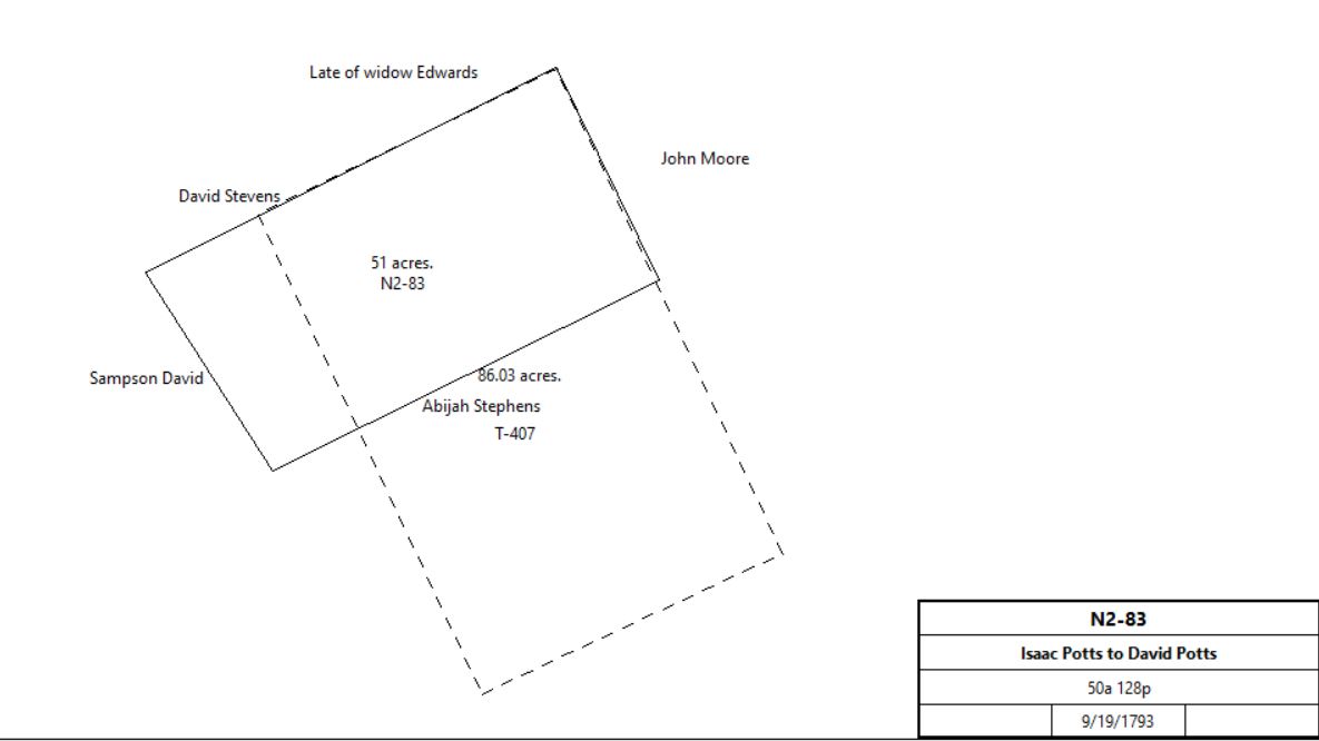
Isaac Potts |
David Potts |
9/19/1793 |
50a 148p |
£350 |
N2-83; see deed plan |
|
David & Mary Potts |
Wm. Davis Sr. |
4/1/1796 |
50a 148p |
£700 |
N2-85 |
John Havard Jr. |
John Havard Davis |
1797 |
|
|
Estate #4594 |
Dr. John Davis |
|
1798 |
124a |
|
County Tax |
Dr. John Davis |
|
1798 |
123a |
|
Glass tax; log 26’ x 17’, stone barn & waggon house |
William Davis |
|
1798 |
229a |
|
Glass tax; neighbour John Brown |
Dr. John Davis |
|
1799 |
124a |
|
County Tax |
|
|
|
|
|
|
Maurice Stephens |
Wm. Davis Sr. |
2/2/1805 |
32a 112p |
|
Z3-174 |
Adm. of John Havard Davis |
Wm. Davis Sr. |
10/23/1820 |
68a |
|
S3-309 |
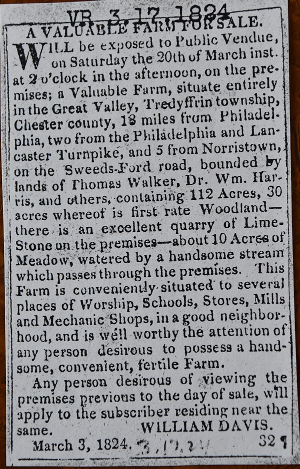
Village Record 3-17-1824
See Newspaper clipping in Document database for commentary
|
Wm. Davis Sr. |
Samuel H. Davis |
1848 |
175a |
|
Estate #11389 |
Samuel H. Davis |
Wm. Davis Jr., Sarah, Rebecca, Mary, Hannah, & Cyrus H. Davis |
1860 |
175a |
|
Estate #13885 |
Sarah Feree |
William Davis |
1853 |
1/6 175a |
|
Estate #13135; will proven 1/26/1865 |
Hannah Davis |
Heirs: brothers, sisters & nephew |
1876 |
1/6 175a |
|
Estate #18160 |
Wm. Davis Jr. |
Heirs: Rebecca & Mary Davis, Cyrus H. Davis |
1879 |
1/6 175a |
|
Died 6/29/1879. Estate #19100 |
Rebecca & Mary Davis |
Cyrus H. Davis |
2/17/1880 |
1/3 175a |
$1 |
G9-34; Release; see deed plan |
Cyrus Davis |
|
1883 |
115a |
|
Breou’s Atlas |
Cyrus H. Davis |
Girard Life Ins. |
12/30/1886 |
176a 116p |
|
Mort. Def. |
Sheriff |
Mary E. S. Evans |
8/26/1887 |
176a 116p |
|
Sheriff's deeds 12-220 (Chester) 438-49 (Montgomery) |
Mary E. S. Evans |
Commonwealth of Pennsylvania |
1897 |
|
|
deed not found |
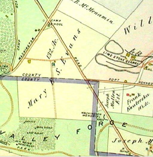
Mueller's atlas, 1912
|
Mary E. S. Evans |
Comm. Of PA |
5/1/1924 |
50.63a + 18.1a |
$22,484 |
D18-265 |
Mary E.S. Evans |
|
1912 |
|
|
Park map |
Mary E. S. Evans |
Comm. Of PA |
5/1/1924 |
86a 67p |
$18,500 |
U12-92 |
|
|
V-182 Beginning at a marked white oak, being a corner of the lands of John Moore and widow Edwards, thence S65°W across a road to Valley Forge leading out of the great road to Lancaster 93 perches to a post, thence by land of Nathan Evans & Griffith John S25°E 148 perches to a post, thence by land of Daniel Walker N65°E 93 perches to a post, thence by other land of Stephen Evans and John Moore recrossing said road N25°W 148 perches to the place of beginning.
T-407 Beginning at a white oak, in a line of widow Edwards’ land, thence by the same S64°W 93 perches to a post, thence by land of Nathan Evans & Griffith John S25°E 148 perches to a post, thence by land of Daniel Walker N65°E 93 perches to a post in the line of Stephen Evans, thence by same and land of John Moore N25°W 148 perches to the place of beginning.
N2-85 Beginning at a heap of stones, being a corner of the land late of Sampson David and by land of David Stephens and land late of the widow Edwards N63° 35’E 128.1 perches to a white oak sapling marked for a corner in John Moore’s land, and then by Moore’s land S25° 45’E 66 perches to a heap of stones, thence by land of Abijah Stephens S63° 45’W 120½ perches to a heap of stones, thence by land late of Sampson David N32° 45’W 65½ perches to the place of beginning.
|
