|
Note: in these deed histories distances are quoted in perches (p) of length 16.5 feet. Areas are quoted in acres (a) and square perches (p). There are 160 square perches to an acre. In a few cases roods (a quarter of an acre) are also used.
|
|
|
From |
To |
Date |
Area |
Cost |
Reference |
|
|
|
|
|
|
Proprietors |
David Powell |
4/16/1701 |
1000a |
|
Patent A3-70 |
David Powell |
Henry John |
12/24/1714 |
100a |
£20 |
S-384 |
|
|
5/17/1715 |
|
|
Receipt for £20 signed by David Powell and witnessed
by John Cadwalader. – Frances Ligget's article on Stirling's Quarters. |
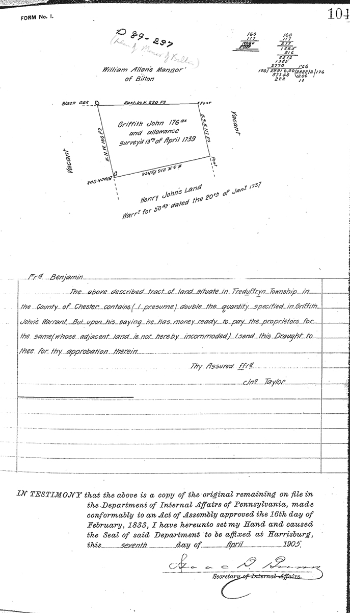
Proprietors |
Griffith John |
4/13/1739 |
176a |
|
Survey C89-104; also see Griffith John Warrant for smaller area dated 1/20/1737 |
 |
Proprietor – patent |
Griffith John |
5/13/1740 |
100a |
|
Phila. A10-111; see plan |
John Jones |
|
|
|
|
Shown as owning the land on Taylor deed plan; |
Henry John |
Griffith John |
11/20/1737 |
100a |
|
S-349 (brothers) |
Griffith John |
Thomas John |
12/8/1752 |
100a |
5s |
S-350 |
Griffith John senior |
Griffith John junior |
7/31/1753 |
100a |
|
To grandson on achieving maturity. This contradicts previous deed. Perhaps there was a swap with land in Charlestown. See deed E-520 |
Griffith John |
Thomas John |
11/29/1753 |
176a |
|
Estate #1510a Will. Thomas owned 276 acres in 1760 tax list |
Thomas John |
Joseph Williams |
12/7/1754 |
176a |
£368 |
I-269a Mortgage |
Thomas John |
Joseph Walker, Joshua Evans, William Curry, John Davies, Thomas Waters, & Daniel Walker |
12/31/1759 |
100a |
£80 |
L-408 Mortgage; see deed plan (problematic) |
Thomas John |
Jos. Williams |
12/7/1764 |
176a |
|
O-43 Mortgage |
Thomas John |
Estate |
6/8/1766 |
|
|
Estate #2326 a |
Sheriff (Adm. Of Jos. Williams) |
William Currie |
9/28/1769 |
176a |
£500 |
P-132; see deed plan |
Sheriff |
William Currie |
5/28/1767 |
100a |
£214 |
P-129 |
|
|
Patent, Commissioners of William Penn to Griffith John, dated 5/13/1740
Beginning at a post a corner of Henry John, thence by same WSW 216 perches to a black oak, thence by vacant land NNW 160 perches to a black oak in line of Bilton line, thence by same NE 221 perches to a post, thence by vacant land SSE 117 perches to place of beginning.
I-269 Mortgage. On 7 Dec 1754 Thomas John of Tredyffrin, carpenter, & Hannah his wife to Joseph Williams of Lower Merion of the County of Philadelphia, tanner. Thomas John stands bound to Joseph Williams for £400 conditioned on payment of £200 plus interest in yearly payments to be paid in full on 7 Dec 1757. Thomas John to better secure said payment granted to Joseph Williams a tract in Tredyffrin bounded by the Manor of Bilton & vacant land containing 176 acres, it being the tract which the Proprietors by deed dated 13 May 1741 granted to Griffith John, the father of Thomas John, which Griffith John by his will dated 31 July 1753 devised to his son Thomas John. Signed Thomas John & Hannah John. Delivered in the presence of Joseph Richards & Morton Morton. Recorded 23 Dec 1754.
P-129 Beginning at a post near a white oak a corner of John Havard, thence by same E20ºN 250 perches to a white oak, another corner of Havard, thence NNW 10? Perches to a post, W23ºN 360 perches to a post, SSE 80 perches to place of beginning.
P-132 Beginning at a post at a corner of Henry John’s land, and extending thence by same WSW 216 perches to a Black Oak, thence by vacant land NW 160 perches to a Black Oak in the line of the Manor of Bilton, thence by the same E by N 220 perches to a post, thence by vacant land SSE 117 perches to the place of beginning.
|
|
Table R.1 William Potts Farm
|
From |
To |
Date |
Area |
Cost |
Reference |
|
|
|
|
|
|
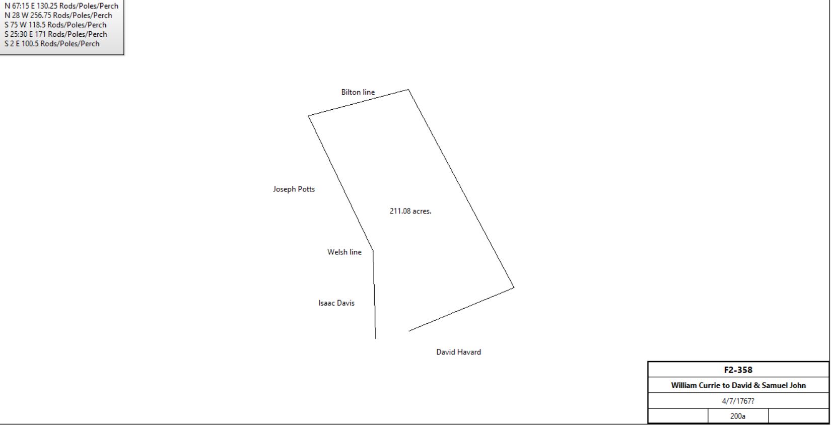
William Currie & wife Margaret |
David & Samuel John |
4/7/1767? |
200a |
£550 |
F2-358 |
 |
David & Samuel John |
William Currie |
4/7/1767 |
200a |
£300 |
P-116 Mortgage |
David & Samuel John |
Edmund Physick |
12/5/1767 |
200a |
|
V-521; Physick attorney to John & Richard Penn |
David & Samuel John |
Jesse Jones |
12/30/1773 |
200a & messuage |
£400 |
T-171 Mortgage; paid off by Edmund Physick 1/4/1777; deed description as G2-338 |
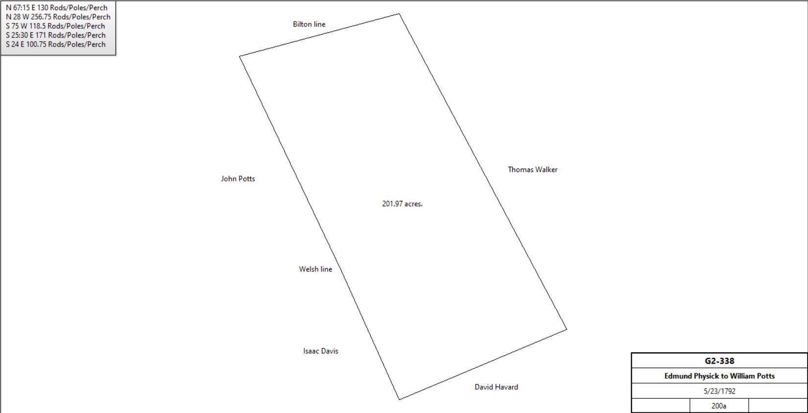
Edmund Physick |
William Potts |
5/23/1792 |
200a |
£1300 |
G2-338; messuage |
 |
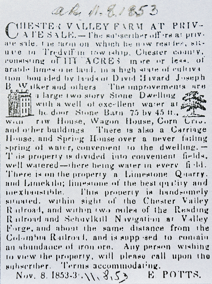
William Potts |
|
1798 |
199a |
|
Glass tax |
William Potts |
Ezekial & William Potts (sons) |
|
|
|
Estate #4972. To wife Hannah in her lifetime. |
William Potts excrs. (Nathan Potts, Thomas Rowland, Ezekial Potts) |
William, Anna, & Hannah Potts |
5/3/1817 |
200a |
|
F4-293. Interest due to Ruth Potts. |
William Potts |
Martha (Evans, then Yeagar), Thomas P., Ezekiel, Hannah II Potts |
12/17/1838 (probated) |
|
|
Estate #9793 Will, dated 4/8/1837, 1/12 shares to 4 children |
Hannah II Potts |
Martha (Evans, then Yeagar), Thomas P., Ezekiel Potts |
5/6/1846 (letters of administration granted) |
|
|
Estate #10961. Will. i.e. Martha (sister), Thomas and Ezekiel (brothers) now hold 4/36 = 1/9 shares |
Anna Potts |
Hannah Potts (sister) |
1/5/1843 (probated) |
|
|
Estate #10390 Will dated 12/28/1842 |
Hannah Potts |
Thomas P. Potts |
4/7/1848 |
200a |
$1500 |
Q5-224. 1/3 interest. Thomas now has 4/9 interest. |
Hannah & Susanna Potts, Martha Evans, Thomas P., & Isabella R. Potts |
Ezekiel Potts |
4/10/1848 |
114a 131p |
$6188 43¼c |
G5-414; messuages |
Hannah Potts |
Ezekiel Potts |
12/30/1848 |
|
$1 |
W16-127 |
Susanna, Thomas P. (and Isabella, his wife), Ezekiel Potts (and Joanna, his wife) & Martha Evans |
Joseph B. Walker |
3/30/1852 |
64¾a |
|
R5-270 |
|
Ezekial & Hannah Potts |
Joseph B. Walker |
4/4/1855 |
114a 131p |
$11,000 |
Y5-433 |
Joseph B. Walker |
Tredyffrin School Board |
10/5/1863 |
72p |
|
W6-200 |
Joseph B. Walker |
|
8/2/1879 |
|
|
Died. Executors spilt property into 23 lots for sale.
table R.2 Lots 4,5,6,7
table R.2.3 Lot 2, 8 - 12, 14, 16 - 20
table R.2.4 Lot 15
table R.1.5 Lots #15, #22
Lot 3 John Groff, deed not found |
 |
|
G5-414 Messuage and tract of land in Tredyffrin beginning at a stone, a corner of David Havard, thence by same N68¼ºE 131 perches to a stone, thence by Joseph Walker’s land N26ºW 168.4 perches to a post, thence by other part of this tract S70ºW 100 perches to a post, thence S26ºE 61.2 perches to a post, S45ºW 4¾ perches to a post, S32¼ºE 33.9 perches to a post, N71¾ºE 9¼ perches to a post, S25ºE 21.6 perches to a post, S72½ºW 34.9 perches to a post, S22¼ºE 54 perches to the place of beginning.
Part of Nathan Potts et al, execs. deed in F4-293 to Ann, Hannah, & William Potts, and the said William and Ann having since died, their interest in above mentioned premises became vested in grantors above named.
R5-270 Beginning at a stone in line of Joseph Funk, a corner of grantors, thence along Funk’s land N24½ºW 70.3 perches to a black oak, thence by Samuel H Davis’ land N76ºE 119.26 perches to a heap of stones, thence by grantee’s land S26¾ºE 87.64 perches to line of grantee’s land, and a corner of Ezekiel Potts, thence by same S70ºW 80.3 perches to line of Ezekiel Potts, and along same N69ºW 38.6 perches, thence S84½ºW 14 perches to the place of beginning.
|
Table R.1a
|
From |
To |
Date |
Area |
Cost |
Reference |
|
|
|
|
|
|
Peter Klahr & Mary A., his wife |
M.J. Pennypacker & Annie R., his wife |
7/3/1857 |
0.5a |
|
H6-585 |
M.J. Pennypacker & Annie R., his wife |
Ezekiel Bowen |
3/30/1850 |
|
|
|
Ezekiel Bowen & Elizabeth his wife |
H. & B.F. Bean |
2/1/1871 |
0.5a |
$75 |
Z7-240 |
|
|
Z7-240 Beginning at a stake set at a corner of Richard Rhoda’s land, thence by land of Nicholas Bean N27ºW 15.57 perches to a stake set for a corner in a pile of stones in the welsh line, thence along said Welsh line N73ºE 5.21 perches to a heap of stone a corner of M.J. Pennypacker’s land, thence S273ºE 15.57 perches to a stake set for a corner in a line of Richard Rhoda’s land, thence by said Richard Rhodda’s land S73ºW 5.21 perches to the place of the beginning.
|
Table R.1.1 Groff tract
|
From |
To |
Date |
Area |
Cost |
Reference |
|
|
|
|
|
|
|
Jno. Groff |
1883 |
15-0-0 (part) |
|
Breou’s Atlas |
Execs. of John Groff |
Mary Jane Bean |
1/5/1888 |
5a woodland; Tredyffrin |
|
M10-316
See A12-22 for sale |
Michael Towers (assignee of Mary Jane Bean) |
Mortimer Bickley |
9/12/1899 |
3) 5a Tred.(see M10-316)
|
$8,350 |
A12-22 (see Bean transactions for descriptions of all the tracts) |
Milton & Mary Bickley, Walter & Josephine Bickley, Mary & Henry Robinson, heirs of Mortimer Bickley |
Francis M. Bean |
4/1/1913 |
3) Tredyffrin 5a |
$25,100 |
K14-312 (see Bean transactions for descriptions of all the tracts) |
|
|
Table R.1.2
|
From |
To |
Date |
Area |
Cost |
Reference |
|
|
|
|
|
|
Joseph B. Walker excrs. |
George Fulmer |
4/16/1880 |
20a |
|
R9-92 Lots #4, 5, 6, 7 |
George Fulmer & Hannah, his wife |
Edward B. English |
4/12/1882 |
20a |
|
M9-467 English partner in Cedar Hollow Lime |
|
Cedar Hollow Lime Co. |
1883 |
22-1-13 |
|
Breou’s Atlas |
Edward B. English |
|
|
|
|
Died |
John A. Stambach & Marian E., his wife |
William C. Ferguson (trustee of Cedar Hollow Lime) |
6/22/1898 |
17 tracts, #7 being 4 lots of 20a.
Tredyffrin
#1 9a 57¼p
#2 6a 101p (see table I.2)
#3 4a 18p
#4 25a 140¼p
#5 10a (JW #15)
#6 8a 78p (JW #1)
#7 20a (JW #4,5,6,7)
Charlestown
#10 1a
#11 3¾a 17p
#12 35a 85p
#13 5a
#14 11a 50p
#15 3a 58p
Schuylkill
#8 3a 147p
#9 5a 152p
#16 5a 81p
#17 4a |
$1 |
Y11-33 Marian, daughter of Edward B. English. |
|
|
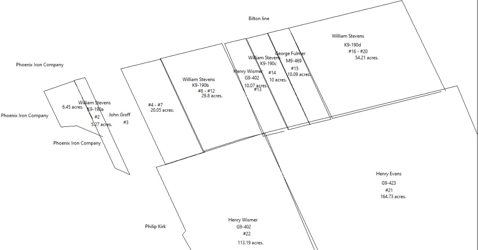
R9-90 Beginning at a stake a corner of lot #8 sold to William Stephens in line of lot #23 sold to Henry Wismer, known as the Potts farm, thence by same S72º 12’W 35.5 perches to a stake, a corner of lot #3, thence along same N24º 50’W 92.35 perches to a stake in line of Bilton Manor, thence by same N76¼ºE 35.88 perches to a corner of lot #8, and along same S24º 50’E 89.9 perches to the place of beginning.
|
|
Table R.1.2a
|
From |
To |
Date |
Area |
Cost |
Reference |
|
|
|
|
|
|
William C. Ferguson (trustee of Cedar Hollow Lime) |
John Dunn |
2/6/1889 |
10a + 20a |
$250 |
A12-50
See table R.2.4 |
John Dunn & Elizabeth, his wife |
C. Arthur Fisher |
5/8/1899 |
10a (Joseph Walker plot #15)
20a (Joseph Walker plot #4,5,6,7) |
$1 |
T11-196 |
C. Arthur & Annie Fisher |
Charles Hires |
9/23/1918 |
10a 11p |
$1 |
L15-67 |
|
|
Table R.1.3 - retired
|
|
Table R.1.4
|
From |
To |
Date |
Area |
Cost |
Reference |
|
|
|
|
|
|
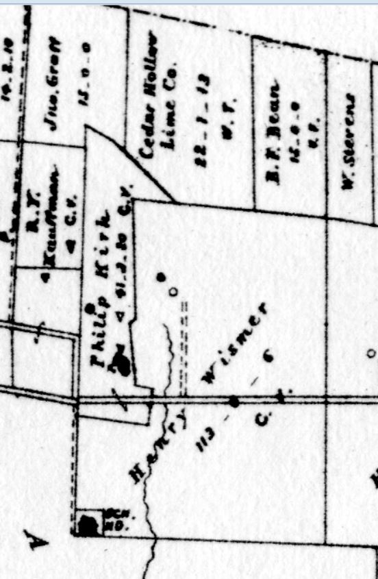
Jeremiah H. & Martha Yeager, Thomas P.,& Isabella Potts, Ezekiel & Joanna Potts |
Philip Kirk |
4/3/1860 |
30a |
$3000 |
R6-56 |
Philip Kirk |
|
1883 |
41a |
|
Breou’s Atlas |
 |
|
|
R6-56 Tract of land with buildings thereon situated in Tredyffrin, beginning at a post in the public road, thence by Jos. B. Walker N72½°E 34.9 perches to a post, thence by same N25°W 21.6 perches to a post, S71¾°W 9.25 perches to a post, N32¼°W 33.9 perches to a post, N45°E 4.75 perches to a post N26°W 61.2 perches to a post, N70°E 19.7 perches to a post, thence N69°W 38.6 perches to a post, N84½°W 14 perches to a post, thence by land now or late of Valentine Kugler S23½°E 107 perches to a stone, thence along middle of public road S22°E 46.75 perches to the place of beginning. Contain 30 acres; part of F4-293.
|
Table R.1.5
|
From |
To |
Date |
Area |
Cost |
Reference |
|
|
|
|
|
|
William H. & William S. Walker (execs of Joseph B. Walker) |
Henry Wismer |
4/16/1880 |
113a 6p + 10a (lot #13) |
$8105 |
G9-402 |
Henry Wismer |
|
1883 |
113.6a |
|
Breou’s Atlas, lot #23? See table R.2.1 |
Henry & Elizabeth Wismer |
Martha Jane Bean |
5/14/1891 |
10a |
$700 |
Y10-278 |
William Turner, sheriff, debt of Martha Jane Bean (widow of Benjamin Franklin Bean) |
Francis M. Bean |
4/26/1900 |
... + 40a woodland in Tredyffrin ... |
$207 |
Z11-412; see table R.2.3 for 5, 10, and 15 acres |
|
Table R.1.6 Part of William Potts Farm
|
From |
To |
Date |
Area |
Cost |
Reference |
|
|
|
|
|
|
Valentine Kugler |
John Ely and Abraham Weaver |
6/21/1854 |
|
|
Deed not found; quoted in X8-151 |
John & Salome Ely |
Seyfert McManus & Co. |
6/23/1854 |
½ part |
|
Deed not found; quoted in X8-151 |
Abraham Weaver |
John Ely |
3/14/1855 |
½ part |
|
Deed not found; quoted in X8-151 |
John & Salome Ely, & Seyfert McManus & Co. |
Philip Kirk |
3/23/1867 |
5a 140p |
$550 |
X8-151 |
Wilmer & Charles H. Kirk, executors of the will of Philip Kirk |
Jacob Rickabaugh |
10/24/1896 |
30a + 6a + 5a 140p |
$3,000 |
R11-226 |
Jacob Rickabaugh & wife |
Charles H. Kirk |
12/9/1896 |
30a + 6a + 5a 140p |
$3,000 |
Q11-89 |
T. Rushton Griffith & wife |
Charles H. Kirk |
5/27/1912 |
|
|
F14-467 |
Charles H. Kirk |
Ethel M. Hershey |
8/21/1913 |
15a |
|
Will 40-382 |
Herbert T. Hershey & wife |
Mary L. Dewees |
5/29/1925 |
41a 140p |
|
W16-121 |
|
|
Miscellaneous Vol. 47 p. 89 Petition of Mary L. Dewees & Ethel M. Hershey for release of charge due Ruth Potts in F4 293. Mary’s land bounded by that of Joseph Walker, John N. Sanderson estate, land late of Valentine Kugler, Ethel M. Hershey, Samuel Toner, A. A. Golder, and A.J. Cassatt. Ethel lands bounded on E & S by those of Mary Dewees, N land now or late of, Phoenix Iron Co., W land now or late of Samuel Toner.
|
Table R.2 William Currie / Stirlings Quarters
|
From |
To |
Date |
Area |
Cost |
Reference |
|
|
|
|
|
|
William Currie |
Thomas Forrest |
1789 |
240a |
|
Mortgage Book C-271 |
William Currie |
Thomas Walker |
10/25/1791 |
200a |
|
G2-53 |
Thomas Walker |
Joseph Walker |
4/13/1839 |
|
|
Estate #9829 |
|
|
|
|
|
Split in property with Joseph B Walker’s death (see Table R) |
|
Table R.2.1
|
From |
To |
Date |
Area |
Cost |
Reference |
|
|
|
|
|
|
William S. Walker |
Henry Evans |
4/16/1880 |
163a 33p |
$13,260 50c |
G9-423a |
Henry L. Evans |
Pedro Salom |
9/30/1899 |
130.61a |
|
E11-293 |
|
Henry Wismer |
1883 |
113.6a |
|
Breou’s Atlas, lot #23? |
John H. Sanderson |
|
1912 |
113a 6p |
|
Mueller’s map |
Pedro Salom |
Robert Ligget |
4/8/1926 |
113a 6p |
|
E17-137 |
Robert Ligget |
Ethel Ellison |
9/14/1934 |
A tracts - Philadelphia; B - Lower Merion; C - Waynesborough farm; Tredyffrin D1 - 113a 6p; D2- 130.061a; D3 - 2.988a + 0.432a; D4 72p. |
$1 |
T18-8 |
Ethel Ellison |
Robert Ligget |
9/14/1934 |
as above |
$1 |
T18-14 |
Audrey Snyder and Fidelity Bank, co-trustees, Frances Ligget |
United States of America |
2/22/1978 |
65.49 |
$670,000 |
T52-393; special warranty deed |
|
|
2022 |
45.4a |
|
GIS database tax parcel 43-5-2.1 |
|
|
2022 |
20a |
|
GIS database tax parcel 43-5-12.1 |
|
|
G9-423 Beginning at a hickory tree in the middle of a public road thence by land of Peterson N22½°W 147.61p to a corner of woodland of the said Joseph B. Walker deceased thence by said woodland S76¼°W 172.41p to a corner of other land of the said Joseph B. Walker deceased known as the Potts Farm thence by said Potts Farm S24°50’E 168.41p to a stone a corner in the line of David Havard’s land, thence by said land and land of Edward Wilson N69½°E 161.41p to the place of beginning.
|
Table R.2.1.1 Far Fields Farm aka Echo Valley Farm
|
From |
To |
Date |
Area |
Cost |
Reference |
|
|
|
|
|
|
Audrey & Robert C. Ligget, trustees |
Jean & Theodore Kesting |
1/2/1957 |
25.582a |
|
X28-349 |
T & J.M. Kesting |
|
|
25.2a |
|
1963 Franklin map |
Theodore (Ted) Kesting |
Mary & Ralph Claypoole |
1/10/1968 |
25.582a |
|
Z37-7 |
Carol Claypoole & Nathan Margulies, executors of the estate of Mary & Ralph Claypoole |
King’s Grant Holdings (Jeff King) |
11/21/2003 |
25.582a |
$3,000,000 |
5995-1021 |
|
Table R.2.1.2 Argyle House
|
From |
To |
Date |
Area |
Cost |
Reference |
|
|
|
|
|
|
Audrey & Robert C. Ligget, trustees |
Froelich Rainey |
8/18/1950 |
5.53a |
$38,000 |
P24-176 |
Froelich Rainey |
Penelope Rainey |
9/19/1973 |
5.53a |
$1 |
T43-39 |
Penelope Lewis, formerly Penelope Rainey |
Philip & Claire Eitzen |
2/13/1981 |
5.53a |
$225,000 |
A58-4 |
Philip & Claire Eitzen |
Daniel Piazza |
1/3/2004 |
not quoted |
$1,345,000 |
6054-115 |
|
|
2022 |
5.5a |
|
GIS database tax parcel 43-5-1 |
|
Table R.2.1.3
|
From |
To |
Date |
Area |
Cost |
Reference |
|
|
|
|
|
|
Audrey Snyder & Fidelity Bank, trustees |
United States of America |
9/27/1982 |
60.69a |
$407,000 |
M60-109; special warranty deed |
|
|
2022 |
30.6a |
|
GIS database tax parcel 43-5-2.2 |
|
|
2022 |
30a |
|
GIS database tax parcel 43-5-12.2 |
|
Table R.2.2 - retired
|
Table R.2.3
|
From |
To |
Date |
Area |
Cost |
Reference |
|
|
|
|
|
|
Joseph B. Walker excrs. |
William Stephens |
4/16/1880 |
a) 5a 41p, lot #2
b) 30a, lots #8 - 12
c) 10a, lot #14
d) 53a 57p, lots #16 - 20 |
|
K9-190 |
William Stephens |
William H. Walker |
5/4/1881 |
15a, 10a,10a, and 53a 57p (4 lots) |
$942 25c |
J9-224a |
William H. Walker |
Martha Jane Bean |
1/13/1882 |
15a |
$325 |
M9-84 |
W. H. Walker |
|
1883 |
10a |
|
Breou’s Atlas |
W. Stevens |
|
1883 |
|
|
Breou’s Atlas |
William & Mary Stephens |
Martha J. Bean |
1/8/1885 |
5a, lot #11 |
$500 |
V9-300; see table R.1.5 above |
William H. & Charlotte Walker |
Martha J. Bean |
5/22/1885 |
10a |
$325 |
V9-299; see table R.1.5 above |
William H. Walker |
B.J. Fisher |
8/13/1894 |
15a, 10a, 10a, and 53a 57p (4 lots) |
$1500 |
M11-34a |
Mary, Catherine & William M.Stevens, heirs of William Stevens |
John Ritenhouse |
7/8/1900 |
5a 43p, lot #2 |
$341 60c |
D12-305 |
B.J. Fisher’s excrs. |
Charles E. Hires |
9/17/1918 |
Total Fisher plot |
$1 |
|
|
|
K9-190 Tract #3: Beginning at a stake in line of tract purchased by Henry L. Evans, a corner of lot #15, sold to George Fulmer, thence S76º 4’W 18.66 perches to a stake, thence N24º 50’W 87.4 perches to a corner of lot #13 sold to Henry Wismer and in Bilton Manor line, thence N76¼ºE 18.66 perches to a stake in Bilton Manor line a corner of lot #15, thence by same S24º 50’E to the place of beginning. Lot #14
Tract #4: Beginning at a corner of the farm sold to Henry L. Evans, thence S76¼ºW 97.76 perches to a corner of farm tract and also a corner of lot #15, thence N24º 50’W 87.4 perches to a stake in Bilton Manor line, thence N76¼ºE 101.36 perches to a stake, thence S22½ºE 87.4 perches to the place of beginning.
J9-224 Beginning at a stake corner of lot #11 sold to William Stephens and in line of farm of Henry Wismer, thence S72.2ºW 27.23 perches to a stake corner of land sold to George Fulmer, thence N24º 50’W 89.9 perches to a stake in Bilton Manor line, thence N76¼ºE 27.56 perches to a stone corner of land of William Stephens, thence Lots #8,9,10.
Beginning at a stake in the line of the farm sold to Henry L. Evans thence S76¼ºW 18.66 perches to the corner between Evans and Henry Wismer, thence N24º 50’W 87.4 perches to a stone, thence N76¼ºE 18.66 perches, thence S24º 50’E 87.4 perches to the place of beginning. Lot #12
Beginning at a stake in the line of land of Henry L. Evans thence S76¼ºW 18.66 perches, thence N24º 50’W 87.4 perches to a stake, thence S76¼ºE 18.66 perches, thence S24º 50’E to the place of beginning. Lot #14
Beginning at a stone corner of farm tract of Henry L. Evans thence S76¼ºW 19.76 perches to a stake corner of lot #15 sold to George Fulmer, thence along Fulmer’s land N24º 50’W 87.4 perches to a stake in Bilton Manor line, thence N76¼ºE 101.36 perches to a marble stone in Bilton Manor line, thence S22½ºE 87.4 perches to the place of beginning. Lots #16,17,18,19,20
|
Table R.2.4 (branch 15 of 2327)
|
From |
To |
Date |
Area |
Cost |
Reference |
|
|
|
|
|
|
Joseph B. Walker excrs. |
George Fulmer |
4/16/1880 |
10a |
$55 |
R9-92 |
George Fulmer and Hannah, his wife |
Edward B. English |
4/12/1882 |
10a |
$55 |
M9-469, lot #15 |
|
Cedar Hollow Lime Co. |
1883 |
|
|
Breou’s Atlas |
John A. Stambach & Marian E., his wife |
William C. Ferguson (trustee of Cedar Hollow Lime) |
6/22/1898 |
17 tracts,
#5 10a (JW #15) |
$1 |
Y11-33 Marian, daughter of Edward B. English. Also see table R.2 |
William C. Ferguson |
John Dunn |
2/6/1899 |
#1 10a |
|
A12-50
See table R.1.2a |
John Dunn & Elizabeth, his wife |
C. Arthur Fisher |
5/8/1899 |
10a (Joseph Walker plot #15)
20a (Joseph Walker plot #4,5,6,7) |
$1 |
T11-196 |
C. Arthur Fisher |
Benjamin F. Fisher |
9/23/1901 |
10a. Tract #5 |
|
G12-435 |
|
