|
|||||||||||||||||||
|
Mines Menu:
Mines Map
Use the links at the left to return.
|
|||||||||||||||||||
Mine Descriptions |
|||||||||||||||||||
Blue Nose Mine | |||||||||||||||||||
|
Alternate NamesAbe Lincoln Mining District and MinesHarshaw District
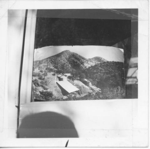
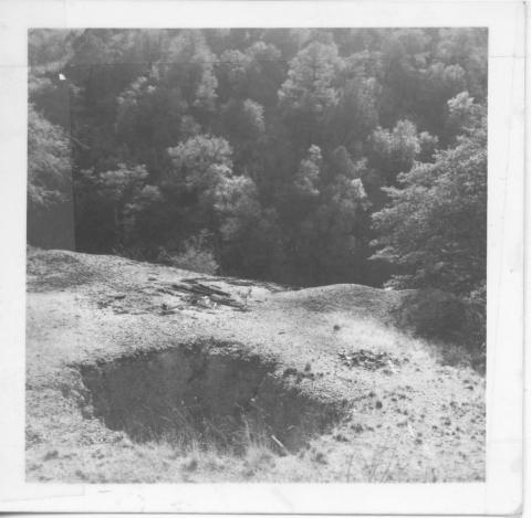
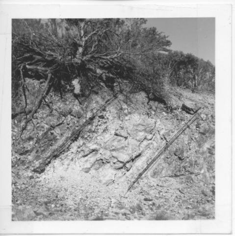
The Blue Nose, also known as the Abe Lincoln mine, is 2 miles southwest of Harshaw, near the south line of the district just west of the Mowry stage road, on open ground. It is owned by R. R. Richardson and Neil McDonald. It has produced $250,000 in lead-silver ore. About 3,000 tons of good-looking ore lies on the dump, the size of which shows that much work has been done. The mine is developed to a depth of more than 200 feet, mainly by shafts and drifts. Work ceased, it is said, because the poor equipment then on the ground was unable to handle the water. The country rock is the Paleozoic limestone and quartzite series and it is intruded by dark-greenish, slate-colored dense glassy rhyolite, seemingly in the form of intrusive sheets. The rocks dip about 40° NW, and are sliced by a prominent sheeting that dips 80° SE. Water, which seemingly is ground water, stands at about 200 feet below the surface. The deposits occur in a vein or lode which dips 40° NW, about conformable with the inclosing rocks. It is about 4 feet in width. The footwall, a sheet of dense dark rhyolite, is pyritic, being impregnated with small crystals and grains of pyrite and chalcopyrite. The ore occurs in pockets, mostly in a white talclike substance. Most of the ore is produced is said to have occurred in a dipper-shaped body2. Arizona Department of Mines and Mineral Resources Mining Collection6 http://docs.azgs.az.gov/OnlineAccessMineFiles/A-B/BluenoseSantacruz4b.pdf (detailed reports and photos) The following images are shown at the top of the report: http://docs.azgs.az.gov/OnlineAccessMineFiles/PhotoColl/B/BlueNose_A1093.jpg http://docs.azgs.az.gov/OnlineAccessMineFiles/PhotoColl/B/BlueNose_A1094.jpg http://docs.azgs.az.gov/OnlineAccessMineFiles/PhotoColl/B/BlueNose_A1095.jpg Mindat.org7 A former small surface and underground Ag-Pb-Zn-Cu-Au-Mn (Bi) occurrence/mine located on 4 patented claims in north-central (NW¼SE¼) sec. 8, T23S, R16E (protracted), 2 miles SW of Harshaw, on private property. Located on the west side of Harshaw Creek, 0.75 mile WNW of American Peak. Discovered in 1880 by George McKay. Produced 1884-1956. Owned/operated by Ms Virginia Hay (?-1974). Owned at times, or in part, by R.R. Richardson and Neil McDonald (circa 1915); Powers; the Arizona Patagonia Silver Mining Co.; Hogan; Big Jim Mines, Inc.; Mr. Rupert Beyerle; and, R.L. Brown; the Calumet and Arizona Co.; Mr. Tom Farrell; Mr. Alfredo Valenzuela; Mr. M.F. Jones (owner-1944); Mr. M.A. Hoover and Captain Coy; Mr. H.C. Herrick; and, Louis Verdugo. This mine was worked intermittently from the early 1880's to 1956. Mineralization is pockety, argentiferous galena and other sulfides, partly oxidized, along sheeted fractures close to a major NW-trending fault/fissure zone in Jurassic-Triassic volcanics with interbedded limy, siliceous sediments. The ore zone is 1188.7 meters long, 1.22 meters wide, with a depth to bottom of 60.96 meters, dipping 40NW. Manganese oxides and carbonate are present in the gangue. Ore concentration was secondary enrichment along the fissure. The vein or lode dips 40ºNW., about conformable with the enclosing rocks. It is about 4 feet in width. The footwall, a sheet of the dense dark rhyolite, is pyritic, being impregnated with small crystals and grains of pyrite and chalcopyrite. The ore occurs in pockets, mostly in a white talc-like substance. The volcanic sedimentary rocks are commonly highly altered to epidote, tourmaline, quartz, sericite, kaolinite, alunite and pyrophyllite. Most ore occurs in a dipper-shaped body. Country rock is the Paleozoic limestone and quartzite series (Bisbee Formation) and is intruded by dark-greenish, slate-colored, dense, glassy rhyolite, seemingly in the form of intrusive sheets. The Bisbee Formation is commonly hornfelsed and porphyritic. The rocks dip about 40NW, and are sliced by a prominent sheeting that dips 80SE. Local structures include the NW-trending Blue Nose Fault. Rhyolite forms intrusive sheets in limestone. Tectonic elements include the UX Ranch Fault Block, bounded on the east by the Harshaw Creek Fault and on the west by the Blue Nose Fault; apparent left-lateral slip in relation to the Harshaw Creek Fault and American Mine Fault Block is 4 to 5 miles7. LocationLatitude & Longitude (WGS84): -110.73345, 31.44792 (WGS84) Mineral ProductsIt produced some 13,000 tons of ore averaging about 18 oz. Ag/T, 2% Pb, 1% Zn, 0.5% Cu and minor Au.3 Geology4
Type of Operation and ProductionWorkings include shafts and tunnel operations totaling 441.96 meters long and 60.96 meters deep. Developments included a vertical shaft over 200 feet deep, 1 adit 80 feet long (showing narrow stringers of manganese), a 100 foot long adit, 2 mine dumps and extensive underground workings, plus 3000 feet of surface workings. It is developed to more than 200 feet2. See also https://thediggings.com/mines/16506 (mainly duplicate information) References
MB v1.0 12/2022 | |||||||||||||||||||