|
|
|
Mines Menu:
Mines Map
Use the links at the left to return.
|
|
Mine Descriptions |
|
Boston Gulch Placers | |
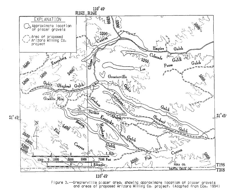
Mining District and MinesGreaterville Area Boston Gulch, which heads in the col south and west of Granite Mountain and trends a little south of east, gold was found in paying quantities from its head to a point about half a mile south of its junction with Kentucky Gulch at the Kentucky Camp. In the upper 2 miles of its course the gold was found in a channel 5 feet wide on bedrock, at 2 to 4 feet below the surface. Below Harshaw Gulch the gold was still confined in a 10 foot channel in the valley bottom, 5 to 10 feet below the surface. Below the mouth of Kentucky Gulch the valley is wide, and for half a mile below this point the gold was distributed on bedrock at a depth of 10 to 16 feet for a width of approximately 50 feet.2 Harshaw Gulch, a short, narrow tributary of Boston Gulch with steep bedrock sides, the pay streak, which in places was rich, was confined to the bottom of the gulch, about 4 feet wide.2
Source of the Placer GoldBetween the latitide of Greaterville, at about the middle of the placer area, and the crest of the Santa Rita range occur, as shown in the discussion of lode deposits, numerous quartz veins, nearly all of which are gold bearing and some of which have produced surface ores rich in gold and silver and bearing nuggets of native gold. These veins havebeen opened at the Yuba, Quebec, and St. Louis mines and many other places in the crumpled altered sediments about the base of granite mountain, where mnay of the richest gulches head. This mountain is composed of intrusive granite porphyry, which is more or less pyritic, and the contained pyrite is thought to be probably aur, just as the pyrite in the Helvetia district is cupriferous. More or less gold is associated also with the rhyolite dikes. It accordingly seems probable that the placers may have been formed by the concentration of the gold freed by long-continued weathering and erosion from the vast amount of rock that was removed from the area extending westward to and beyond the present crest of the Santa Rita Mountains. The talus and wash, at first relatively lean in gold, were originally spread out upon the side of the mountain in a vast, more or less continuous constructional sheet sloping eastwards to towards Cienega Creek. As the top of surface gravels were removed their gold content was mostly left behind, gradually enriching the portion of the sheet that remained. Finally, owing to climatic changes or uplift of the range, the present drainage lines were laid out and developed, whereupon gold extraction and concentration became more intense in the rapid downcutting of the stream courses and the consequent removal of gulch gravels, and this process is still going on. In the process of concentration, where the drainage is normal, certain ledges contribute more to the gulches by which they or their resulting gravels are drained than to others. Another view to acount for the origin of the gold is that it may have been derived from veins in the Tertiary andesite and rhyolite, which contain the gold-producing veins at the Gringo mine, in the Wrightson district, at the Helena mine, in the Helvetia district, and at many other places. There can be no doubt that these rocks, whose remnants, still several thousand feet thick, form the culmination of the Santa Rita range in Old Baldy, 4,000 feet above the placer area, and extend well into the latitude of the placer area, formerly extended much further north and covered not only the axis of the range but most of the placer area. On the removal of these volcanic rocks by weathering and erosion their gold became concentrated in the gravels and gulches in the manner already described. If this view is correct the volcanic rocks should be well represented in the gravels, not so much in the gravels now contained in the placers, which are mostly later than the volcanic gravels, but in those farther east in the Cienega Valley.2 Future of the CampThe richer gulch gravels have been worked over to a considerable extent, but the ground that has been washed still contains some gold, as shown by the production of Mexicans who are working it at sundry locations. The gravels in the sides of the gulches and on the ridges also contain small quantities of gold, and it is quite possible that some pay channels have not yet been discovered. The general consensus of opinion of the several of the best mining engineers who have examined the area is that it still contains about $50,000,000 worth of gold, and according to E. Ezekiel (oral communication), a mining engineer of Tucson, who is familiar with the ground and has made a very complete examination of it independently for a large company, the amount of gold present is more nearly $100,000,000. Besides the above-estimated amount of gold now mostly in sight in the area, it is inferred from geological reasoning that similar and probably workable deposits certainly occur in the deeper gravels east of the present area, which are only just beginning to be exploited. Owing to the scarcity of water the means of working the gravels are limited, and as dry washing has not been a success, owing to the clayey character of the matrix, rocking has been the chief method employed. Where the overburden exceeds 3 or 4 feet in thickness small shafts are sunk to bedrock, and the pay dirt, about 2 feet in thickness at the bottom, is mined out, in some places for a radial distance of 20 feet from the shaft, hoisted by a crude windlass to the surface, and stored in heaps until a sufficient amount for a few days’ rocking has been accumulated. Water is then packed in and the gold, averaging about 40 cents to the cubic yard of gravel, is rocked out, the entire operation frequently being done by one man. Although most of the gold produced was recovered in this way, it is apparent that, the richer gulch gravels being worked out and the remainder being of lower grade, the deposits cannot continue to be profitably worked in this manner. They can be worked with profit only on a considerable scale by dredges or some form of hydraulic machinery which may be found best adapted to the ground.2 Historical: Main Operations 1875 - early 1900s; small sporadic operations since. Estimated production: not less than 29,000 oz. AU and 6,000 oz. Ag. (1) Total production of the camp amounted to about $7,000,000 (3). Most recent activity (1948); 535 oz. gold, averaging 0.006 oz./yard3 mined from Louisiana Gulch (14). Less than $1,000,000 total production (17). Over $73,000 in production from Greaterville placers between 1874 and 1927 (18).1 DevelopmentHistorical: Development was mainly by hand-dug methods, but hydralic mining and deredging also took place (17).1 USBM: Many small pits and shallow shafts, as well as larger cuts and trenches are visible. The area has been worked and reworked many times and workings and prospects range from very old and totally caved to freshly dug pits.1 Geology and MineralizationAuriferous gravel derived from altered gold-bearing intrusive, sedimentary and metasedimentary rocks to the west, deposited in present drainage. Older gravels, which occur on ridges above the present-day drainages, are also gold bearing (1, 3, 13, 15).1 References
|