|
|
|
Mines Menu:
Mines Map
Use the links at the left to return.
|
|
Mine Descriptions |
|
Victor Mine | |
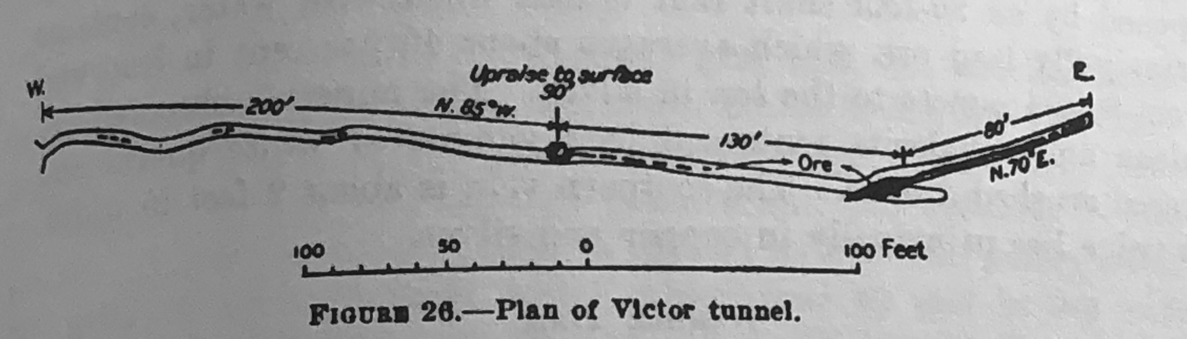
Mining District and MinesSquaw Gulch Area The Victor Mine is a quarter of a mile southeast of the Viceroy mine, in an east fork of Squaw Gulch, at an elevation of 5,580 feet. It was located about 1895. The present owners, Bacon & Koon, of Tucson, relocated it in 1904.2 The mine is opened by a 330 foot tunnel, a 90 foot upraise, and an 80 foot drift (see figure below). The country rock is granite porphyry, and is cut by a system of east-west faults. Some of the fault fissures contain mineral bearing quartz veins, in one of which most of the deposits occur. This vein, which is followed by the tunnelin an irregular eastern course, is 4 to 6 inches wide and is contained between good walls with gouge on either side. At 200 feet in from the mouth of the tunnel occurs an ore shoot, which the upraise follows to the surface. At 130 feet beyond the upraise, where the vein is cut obliquely by a N. 70° E. fault, is a second ore shoot that pitches to the west and has a width of 15 feet on the strike of the vein, and the 80 foot drift extending eastwards on the fault shows about 6 inches of quartz, carrying some mineral. The ore contains principally galena and chalcophyrite in a quartz gangue.2
Historical: tunnel 410 ft. long, with 90 ft. raise to surface (3)1 USBM: Adit, Impassable flooded winze at 12 ft. in from portal, but adit continues; several shafts from 10 ft. deep to unknown depth; and many surface prospects1 Location31.6020N , -110.8309W3 31.60183N, -110.82958W4 SE¼, sec. 17 Mineral ProductsUSBM: Ag, 0.2 - 130 ppm; Au, <5 - 1,220 ppb; Cu, 14- 4,327 ppm; Pb, 220->10,000 ppm; Zn, 22- 30,000 ppm.1 GeologyFissure vein cutting granite. Vein contains quartz, galena, pyrite, sphalerite, chalcopyrite, haematite.1 Type of Operation and ProductionWorked sporadically from late 1800’s through 1959, producing some 800 tons of ore averaging about 10% Pb, 5 oz Ag/t, and minor Zn, Cu and Au. (20)1 References
|