|
| Tredyffrin Easttown Historical Society Home : Tredyffrin History : Original Purchasers Map Use the links at left of the article to return. |
Tredyffrin History Digital ArchivesTable AB - The Tredyffrin Panhandle |
|
Note: in these deed histories distances are quoted in perches (p) of length 16.5 feet. Areas are quoted in acres (a) and square perches (p). There are 160 square perches to an acre. In a few cases roods (a quarter of an acre) are also used. | ||||||||||||||||||||||||||||||||||||||||||||||||||||||||||||||||||||||||||||||||||||||||||||||||||||||||||||||||||||||||||||||||||||||||||||||||||||||||||||||||||||||||||||||||||||||||||||||||||||||||||||||||||||||||||||||||||||||||||||||||||||||||||||||||||||||||||||||||||||||||||||||||||||||||||||||||||||||||
|
Table AB.1East of King of Prussia Road | ||||||||||||||||||||||||||||||||||||||||||||||||||||||||||||||||||||||||||||||||||||||||||||||||||||||||||||||||||||||||||||||||||||||||||||||||||||||||||||||||||||||||||||||||||||||||||||||||||||||||||||||||||||||||||||||||||||||||||||||||||||||||||||||||||||||||||||||||||||||||||||||||||||||||||||||||||||||||
| ||||||||||||||||||||||||||||||||||||||||||||||||||||||||||||||||||||||||||||||||||||||||||||||||||||||||||||||||||||||||||||||||||||||||||||||||||||||||||||||||||||||||||||||||||||||||||||||||||||||||||||||||||||||||||||||||||||||||||||||||||||||||||||||||||||||||||||||||||||||||||||||||||||||||||||||||||||||||
|
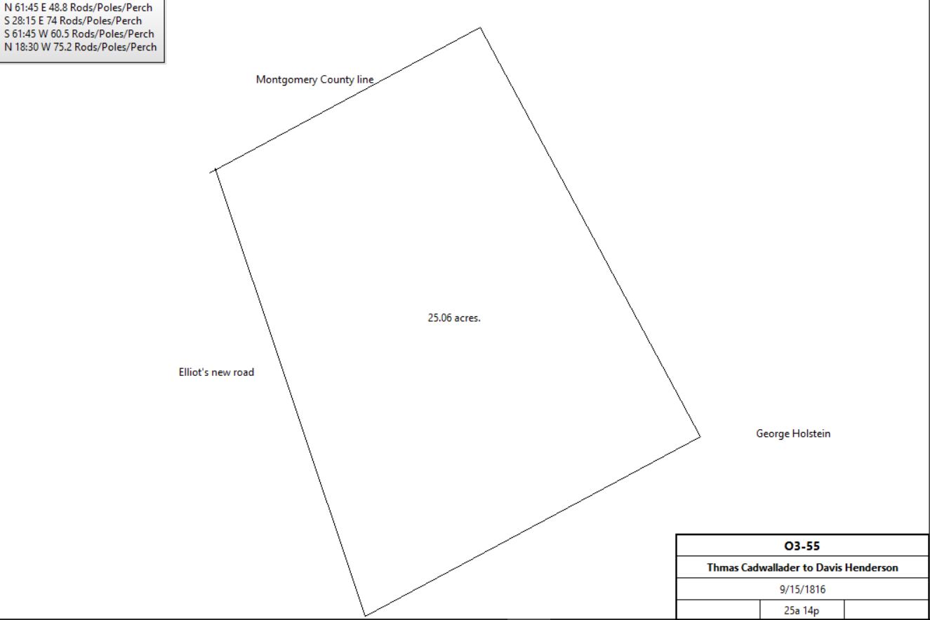
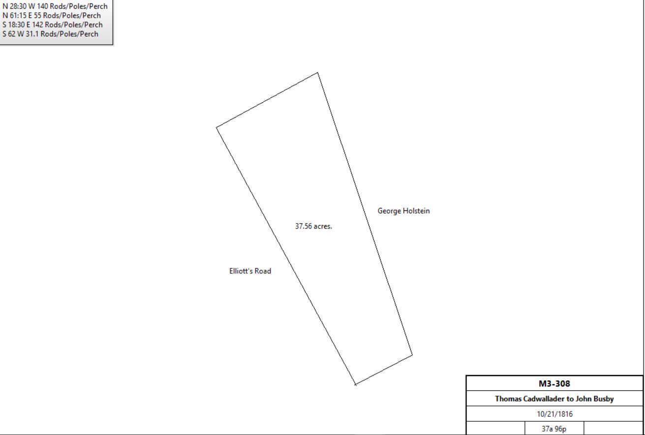
M3-308 Beginning at the SW corner of a large tract of 300 acres, and running thence N28½°W along land of Geo. W. Holstein and others 140p, thence N61¼°E 55p to the west side of Elliott’s road; thence along said road S18½°E 142p to a marked chestnut tree; thence S62°W 31.1p to the place of beginning. Mortgage Q-126 Beginning 82.7p from east corner of tract thence N30½°W 107.8p to the line of John Shinlin’s land, thence S60¾°W 81.5p to corner of land sold to Jacob Ramsey and John Cain, thence S30½°E 107.3p to C. Griffiths, thence N62°E 81.5p to the place of beginning. Lot #17? S3-149 Beginning at a stake and running thence N28°W 57p along lands of George W. Holstein, John Supplee, and John Busby; thence N57¾°E 41.3p by land of John Busby; thence S18½°E 61p along Elliott’s new road; thence S62°W 31.1p to the place of beginning. | ||||||||||||||||||||||||||||||||||||||||||||||||||||||||||||||||||||||||||||||||||||||||||||||||||||||||||||||||||||||||||||||||||||||||||||||||||||||||||||||||||||||||||||||||||||||||||||||||||||||||||||||||||||||||||||||||||||||||||||||||||||||||||||||||||||||||||||||||||||||||||||||||||||||||||||||||||||||||
|
Table AB.2Between Radnor Road and King of Prussia Road | ||||||||||||||||||||||||||||||||||||||||||||||||||||||||||||||||||||||||||||||||||||||||||||||||||||||||||||||||||||||||||||||||||||||||||||||||||||||||||||||||||||||||||||||||||||||||||||||||||||||||||||||||||||||||||||||||||||||||||||||||||||||||||||||||||||||||||||||||||||||||||||||||||||||||||||||||||||||||
| ||||||||||||||||||||||||||||||||||||||||||||||||||||||||||||||||||||||||||||||||||||||||||||||||||||||||||||||||||||||||||||||||||||||||||||||||||||||||||||||||||||||||||||||||||||||||||||||||||||||||||||||||||||||||||||||||||||||||||||||||||||||||||||||||||||||||||||||||||||||||||||||||||||||||||||||||||||||||
|
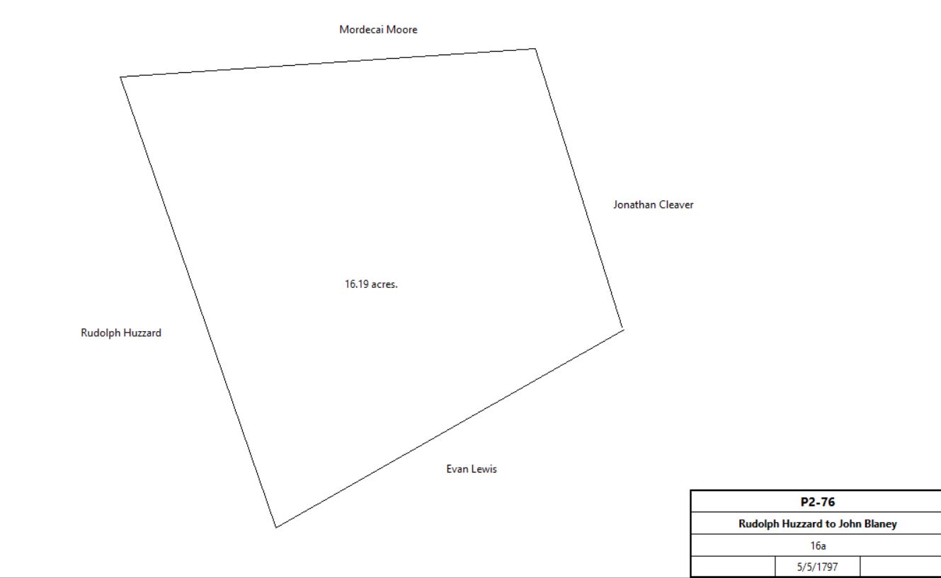
Beginning at a line of land of Penrose at the corner of the land late of Jonathan Davis; thence N27½°W 144p to the Gulph Road; thence along said road E 268p to a stone, and line of the land of John Weal; thence by said land S27½°E 22p to the line of Radnor township, thence along said line S62½°W 236p to the place of beginning. S2-142 Beginning at a heap of stones near the Gulph Road being a corner of Lewis Maule’s land, and in the line of John Weal’s land; thence by the same S28½°E 22.6p to a heap of stones, being a corner of Evan Lewis’ land; thence by the same S61¾°W 36.9p to a stake by the corner of the fence, thence by land of John Maule N17°W 39p to a stake; thence by land late of Lewis Maule S89½°E 33.5p to the place of beginning. H2-33 North side of Gulph Road. Beginning at a stone heap in Jacob Huzzard’s land; thence N62½°E 134 perches to a marked hickory; thence (S27½°)E 102 perches to a chestnut tree by the Gulph Road; thence along said road West 152 perches to a stone; thence N27½°W 32 perches by land of said Huzzard to the place of beginning. 56 acres. North side of Gulph Road. Beginning at a ? on the side of Gulph Road, being the corner of Thomas Maule’s land; thence N27½°W 48.2 perches to a corner stone, being also a corner of land late of the said Ebenezer Maule; thence N77°E 107 perches by the said land to a stone in a line of land formerly of John Weal; thence S27½°E 76.2 acres by said John Weal’s land to a stone, being a corner of John Maule’s land on the side of said Gulph Road; thence West 116 perches along said Gulph Road to the place of beginning. 40 acres. W2-280 Beginning at a stone being a corner of Abijah Stephen’s land and land of John McAfee, thence by said John McAfee’s land N75°E 117½ perches to a stake near a marked chestnut oak; thence by land of Phineas Bond S28°E 76 perches to a heap of stones, being a corner of John Cleaver’s land; thence by the same and land of John Maule N89¾°W 151.2 perches to a stake, thence by Abijah Stephen’s land N15’E 34.6 perches to the place of beginning. 42 acres 148 perches Beginning at a heap of stones, being a corner of Peter Eager’s land, thence by land of John Huzzard N35¾°W 30.4 perches to a heap of stones, being a corner of Benjamin’s Jones land; thence by the same N62¼°E 13.2 perches to a stake, thence by land of Abijah Stephens S36¾°E 38 perches to a stone near said Eager’s house; thence by said Eager’s land N89¾°W 15 perches to the place of beginning. 2¾ acres 35p | ||||||||||||||||||||||||||||||||||||||||||||||||||||||||||||||||||||||||||||||||||||||||||||||||||||||||||||||||||||||||||||||||||||||||||||||||||||||||||||||||||||||||||||||||||||||||||||||||||||||||||||||||||||||||||||||||||||||||||||||||||||||||||||||||||||||||||||||||||||||||||||||||||||||||||||||||||||||||
Table AB.2.1 St. Davids Golf Club
| ||||||||||||||||||||||||||||||||||||||||||||||||||||||||||||||||||||||||||||||||||||||||||||||||||||||||||||||||||||||||||||||||||||||||||||||||||||||||||||||||||||||||||||||||||||||||||||||||||||||||||||||||||||||||||||||||||||||||||||||||||||||||||||||||||||||||||||||||||||||||||||||||||||||||||||||||||||||||
| ||||||||||||||||||||||||||||||||||||||||||||||||||||||||||||||||||||||||||||||||||||||||||||||||||||||||||||||||||||||||||||||||||||||||||||||||||||||||||||||||||||||||||||||||||||||||||||||||||||||||||||||||||||||||||||||||||||||||||||||||||||||||||||||||||||||||||||||||||||||||||||||||||||||||||||||||||||||||
|
Table AB.2.2
| ||||||||||||||||||||||||||||||||||||||||||||||||||||||||||||||||||||||||||||||||||||||||||||||||||||||||||||||||||||||||||||||||||||||||||||||||||||||||||||||||||||||||||||||||||||||||||||||||||||||||||||||||||||||||||||||||||||||||||||||||||||||||||||||||||||||||||||||||||||||||||||||||||||||||||||||||||||||||
| ||||||||||||||||||||||||||||||||||||||||||||||||||||||||||||||||||||||||||||||||||||||||||||||||||||||||||||||||||||||||||||||||||||||||||||||||||||||||||||||||||||||||||||||||||||||||||||||||||||||||||||||||||||||||||||||||||||||||||||||||||||||||||||||||||||||||||||||||||||||||||||||||||||||||||||||||||||||||
|
Table AB.2.3 - John Maule tract | ||||||||||||||||||||||||||||||||||||||||||||||||||||||||||||||||||||||||||||||||||||||||||||||||||||||||||||||||||||||||||||||||||||||||||||||||||||||||||||||||||||||||||||||||||||||||||||||||||||||||||||||||||||||||||||||||||||||||||||||||||||||||||||||||||||||||||||||||||||||||||||||||||||||||||||||||||||||||
| ||||||||||||||||||||||||||||||||||||||||||||||||||||||||||||||||||||||||||||||||||||||||||||||||||||||||||||||||||||||||||||||||||||||||||||||||||||||||||||||||||||||||||||||||||||||||||||||||||||||||||||||||||||||||||||||||||||||||||||||||||||||||||||||||||||||||||||||||||||||||||||||||||||||||||||||||||||||||