|
Note: in these deed histories distances are quoted in perches (p) of length 16.5 feet. Areas are quoted in acres (a) and square perches (p). There are 160 square perches to an acre. In a few cases roods (a quarter of an acre) are also used.
|
|
|
From |
To |
Date |
Area |
Cost |
Reference |
|
|
|
|
|
|
Penn |
John Kinsey |
10/26/1702 |
539a |
|
Patent A2-394. Warrant 8/4/1684; Survey D89-10, 7/15/1702 |
John Kinsey |
Lewis Walker |
2/10/1702-3 |
274½a |
£75 |
B-219; table E.1 |
John Kinsey |
John Roberts |
2/10/1702-3 |
265a |
|
See table E.2 and deed plan in Taylor papers reel 3. In tax record 1718 – 1732. |
|
|
Kinsey’s 539a tract defined in 1760 survey as: ENE 526 perches, NNW 164 perches, WSW 526 perches, SSE 164 perches.
B-219 Deed. On 10 Feb 1702 John Kinsey of the city of Philadelphia, carpenter, to Lewis Walker of Radnor, yeoman. John Kinsey for £75 grants to Lewis Walker a tract bounded by land of David Powell, containing 274 1/2 acres, being part of 539 acres granted to John Kinsey by William Perm by deed dated 26 Oct 1707, recorded Philadelphia, Book A, Vol 2, pages 394 & 395. Signed John Kinsey. Delivered in the presence of Ralph Jackson, William Hoodson, Thomas Story & Maurice Lisle. Recorded 31 May 1708.
|
|
Table E.1 Walker tract
|
From |
To |
Date |
Area |
Cost |
Reference |
|
|
|
|
|
|
John Kinsey |
Lewis Walker |
2/10/1702-3 |
274½a |
£75 |
B-219; |
Daniel Walker |
|
1724 |
|
|
Road plan shows Daniel Walker’s house; see Pulaski’s Quarters |
Lewis Walker |
Daniel Walker |
6/25/1728 |
250a |
£25 |
I-31 |
Lewis Walker |
Enoch Walker |
12/1728 |
74+a |
|
Will |
Enoch & Mary Walker |
Daniel Walker |
12/31/1736 |
74+a |
£80 |
G-387 |
Daniel & Lydia Walker |
William Lewis |
3/22/1748-9 |
74+a |
£60 |
G-435 Mortgage |
Daniel Walker |
Peter Turner |
2/4/1750-1 |
|
£200 |
Mortgage H-84 |
Daniel Walker |
William Currie |
5/28/1751 |
200a |
£491 + £200 (to pay off mortgage) |
I-33; See table E.1.1 |
Penn |
Daniel Walker |
12/4/1751 |
45¾a & allowance |
|
Survey C224-231; north of Kinsey tract but then included in transactions with Kinsey land. |
Daniel Walker |
Execs. of Isaac Walker |
6/15/1756 |
66a |
£22 18s 5d |
K- release |
Daniel & Lydia Walker |
Jacob Walker (son) |
3/5/1767 |
23.25a 66p + 19.75a 19p (total 43.5a 4p) |
£20 |
S-35; see deed plan |
Jacob Walker |
|
1791 |
|
|
House burnt |
Jacob Walker |
Benjamin Jones |
Before 1798 |
2 plots |
|
Deeds not found |
Jacob Walker |
|
1793 |
Inmate |
|
Pennsylvania Septennial Census |
Estate of Richard Walker |
|
1873 |
|
|
Witmer’s Atlas |
M. Walker |
|
1883 |
23a 3p |
|
Breou’s atlas |
Daniel Walker |
Lydia Walker (wife) |
1772 |
|
|
Will #149 |
Pennsylvania Gazette |
|
4/28/1772 |
130a |
|
See description below |
Heirs of Daniel Walker |
Jacob Thomas |
6/15/1772 |
96a 69p |
|
Y-307; See table E.1.2 |
|
|
I-31 Release. On 25 June 1728 Lewis Walker of Tredyffrin, yeoman, & Mary his wife to Daniel Walker, the eldest son & heir apparent of Lewis by the said Mary. Lewis Walker & Mary his wife for £25 & love they bear to their son granted to Daniel Walker a tract in Tredyffrin bounded by land now in the tenure of John David, land of John Haverd, Stephen ap Evan & Lewis Walker containing 250 acres, being part of 539 acres which William Penn granted to John Kinsey by deed dated 26 Oct 1702 recorded in Philadelphia, Book A, Vol 2, Page 394. John Kinsey by deed dated 10 Feb 1702/3 granted 274 1/2 acres to Lewis Walker, recorded in Chester, Book B, Page 19. Signed Lewis Walker & Mary Walker. Delivered in the presence of Thomas Bowater & Daniel Howell. Recorded 15 Sep 1753.
G-387 Release. On 31 Dec 1736 Enoch Walker of Tredyffrin, yeoman, & Mary his wife, to Daniel Walker of Tredyffrin, yeoman. Whereas William Penn, by deed dated 26 Oct 1702, granted to John Kinsey of the City of Philadelphia, carpenter, a tract of 539 acres, recorded in Philadelphia, Book A, vol 2, Page 394. Whereas John Kinsey by deed dated 10 Feb 1702 granted to Lewis Walker, the father of Enoch Walker, a tract containing 274 1/2 acres. Whereas Lewis Walker made his will dated Dec 1728, recorded in Philadelphia 4 Jan 1728 and after bequeathing several legacies, he devised to his son Enoch the tract of land joining the east end of his son Daniel's land. Now Enoch Walker & Mary his wife for £80 grant to Daniel Walker a tract in Tredyffrin bounded by lands of Stephen Evans, Thomas Godfrey, Mary Walker, Thomas Water & other land of Daniel Walker, containing 74+ acres. Signed Enoch Walker & Mary Walker. Delivered in the presence of Francis Wayne, John Phillips & William Moore. Recorded 3 Feb 1748/9.
G-435 Mortgage. On 22 Mar 1748/9 Daniel Walker of Tredyffrin, yeoman & Lydia his wife, to William Lewis of Haverford, yeoman. Daniel Walker & Lydia his wife for £60 granted to William Lewis a plantation & tract of land in Tredyffrin, bounded by land late of Mary Walker, land of Thomas Godfrey, Thomas Waters, Stephen Evans & other land of Daniel Walker, containing 74+ acres. Daniel Walker & Lydia his wife to pay £60 plus interest to William Lewis on or before 22 Mar 1749. Signed Daniel Walker & Lydia Walker. Delivered in the presence of Ruth Jones & David Jones. Recorded 19 May 1749
H-84 Mortgage. On 4 Feb 1750/1 Daniel Walker of Tredyffrin, yeoman, & Lydia his wife, to Peter Turner of the City of Philadelphia, merchant. Daniel Walker is bound to Peter Turner for £400 conditioned on payment of £200 plus interest to Peter Turner on 4 Feb 1751/2. Daniel Walker & Lydia his wife to better secure said payment grant to Peter Turner a tract in Tredyffrin bounded by land of John David, John Havard, Stephen Ap Evan, Lewis Walker, & the road, containing 250 acres. Signed Daniel Walker & Lydia Walker. Delivered in the presence of Nathaniel Grubb & William Melchior. Recorded 11 Mar 1750/1.
Pennsylvania Gazette 4/28/1772 To be sold by public vendue. On the 26th day of the fifth month, May, next,
That valuable plantation and tract of land, late of Daniel Walker, deceased, situate in Tredyffrin, Chester County, containing about 130 acres of good limestone land, about 90 cleared, the remainder well timbered, about 10 acres of valuable meadow, most part of it well watered by a constant stream that runs through it. A good orchard, which is remarked for its bearing, it consists of about 160 apple trees, about 90 whereof are grafted with the house-apple, the rest natural fruit. A good frame dwelling house, 2 stories high, 26 feet by 29 feet; 3 rooms on the lower floor, with fire places in 2 of them; 4 rooms on the second floor with a fire place in one of them; a good garret; the outside boarded and shingled with cedar, the inside done with lime; a good cellar under it; a stone spring house with a constant spring rising in it; a kitchen; weaver’s shop; log barn etc. Likewise to be sold on the premises, the same day, some household goods and implements of husbandry; attendance, and reasonable credit, will be given, and the conditions of sale made known, by Jacob Walker & Samuel Richard, executors. N.B. the sale will begin at 10 o’clock.
|
Table E.1.1 John Beaver Farm
|
From |
To |
Date |
Area |
Cost |
Reference |
|
|
|
|
|
|
Daniel Walker |
William Currie |
5/28/1751 |
200a |
£491 + £200 (to pay off mortgage) |
I-33 |
Proprietors |
Daniel Walker |
12/19/1751 |
45¾a |
|
Philadelphia A16-85 |
Daniel Walker |
William Currie |
12/23/1751 |
16¼a |
£56 17s 6d |
I-35 |
James Davis |
William Currie |
1/25/1762 |
80a |
£150 |
O-547; see table AU |
William Currie |
John Bieber (Beaver) |
4/15/1767 |
200a & 80a & 16¼ |
£1600 |
O-550 |
John Beaver ux |
William Currie |
4/15/1767 |
200a |
£800 |
Mortgage O-498 Paid off 5/25/1774 |
John Beaver |
Margaret Beaver |
1779 |
200a |
|
Estate #3247 |
Margaret Beaver |
Devault Beaver (son) |
2/23/1784 |
170a |
|
Q2-10 |
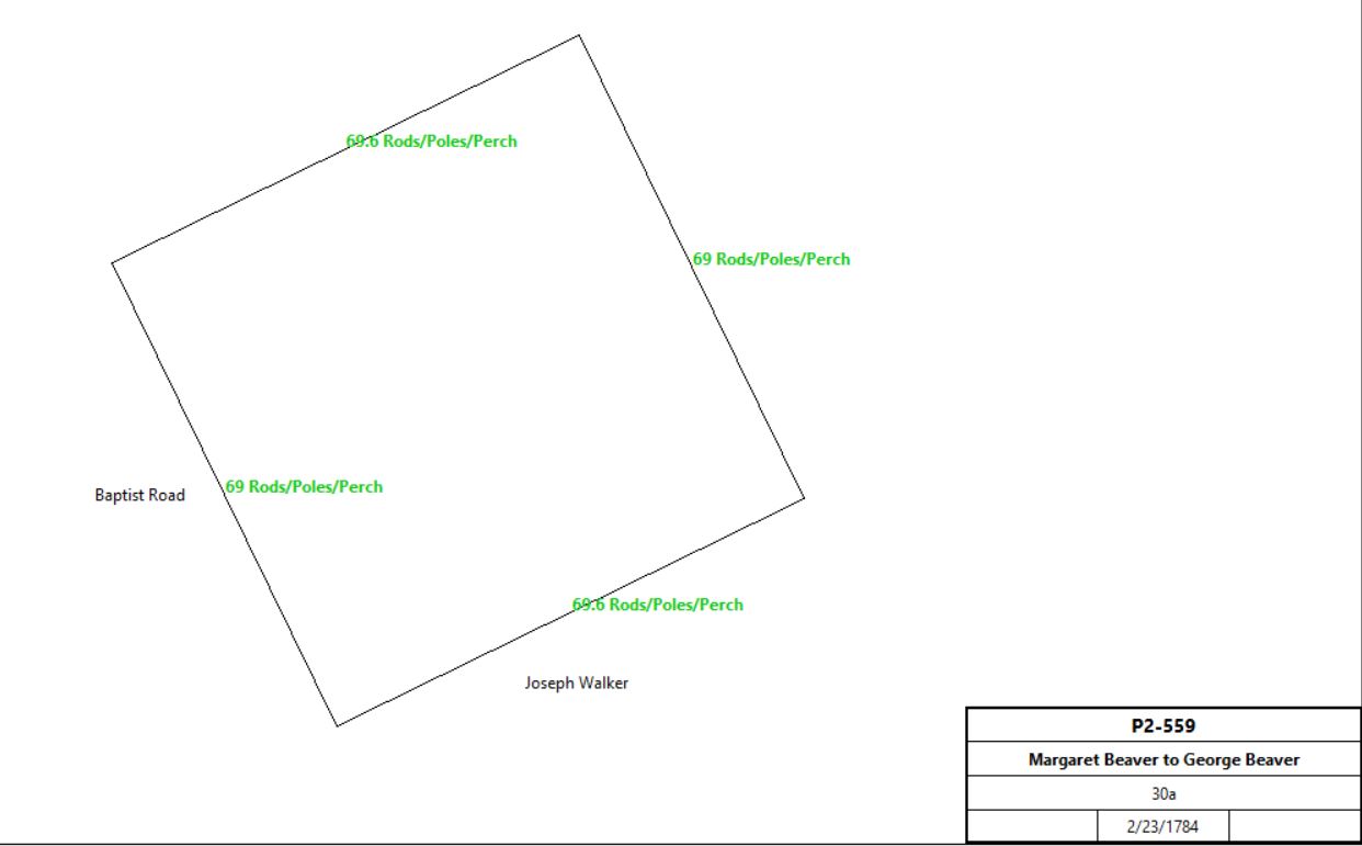
Margaret Beaver |
George Beaver (son) |
2/23/1784 |
30a |
£5 |
P2-559 |
|
Devault Beaver |
|
1798 |
215a |
|
Glass tax; Stone house 30’ x 27’, log barn 40’ x 24’ |
Devault Beaver |
|
1798 |
50a hill land |
|
Glass tax; see table AU |
Devault Beaver |
Margaret Beaver (wife) |
6/2/1835 |
170a |
|
Estate #9608 |
Margaret Beaver, widow, John & Deborah Beaver, George & Ann Beaver, Isaac & Sarah Beaver, Daniel & Catharine Beaver, Daniel H. & Hannah Beaver, David and Samuel Beaver (the last 3 being sons of David ,deceased), George & Sarah Weber, Samuel & Mary Heister, and Catharine Beaver, heirs of Devault Beaver |
Samuel Beaver (son in law) |
3/23/1839 |
170a |
$19,992 |
U4-90 |
Samuel & Elizabeth Beaver |
David Wilson & Henry J. Evans |
4/19/1859 |
170a |
|
Miscellaneous #10-83; Deed of Assignment |
Abiah, Hannah & Mary Baily (creditors of Samuel Beaver) |
|
12/12/1859 |
|
|
Miscellaneous #10-445; agreement to reassign back to Samuel Beaver |
Abraham Dick (creditor of Samuel Beaver) |
|
11/19/1861 |
|
|
Miscellaneous #10-446; agreement to reassign back to Samuel Beaver |
David Wilson & Henry J. Evans |
Samuel Beaver |
11/21/1861 |
170a |
|
Miscellaneous #10-447; Deed of reconveyance |
Samuel & Elizabeth Beaver |
John M. Jones |
2/24/1862 |
118a 8p & 9a 15½p |
$13,100 |
S6-300 |
Samuel Beaver |
heirs |
1873 |
|
|
Estate #17038 |
Adms. of Samuel Beaver |
Dr. Charles N. Frederick |
4/1/1874 |
73a |
|
M8-157 |
Arthur Lanser |
|
1912 |
53a 59p |
|
atlas |
|
|
I-33 Deed. On 25 May 1753 Daniel Walker of Tredyffrin, yeoman, & Lydia his wife to William Currie of Plymouth township in the county of Philadelphia, clerk. Whereas Daniel Walker mortgaged said land here after described, to Peter Turner of the City of Philadelphia, merchant, for £200 plus interest, dated 4 Feb 1750/1, recorded in Chester, Book H, Vol 8, Page 84. Now Daniel Walker & Lydia his wife for as well as the monies to pay said mortgage & £491 granted to William Currie a tract in Tredyffrin bounded by land of Isaac Walker, other land of Daniel Walker & land of John Haverd containing 200 acres. Signed Daniel Walker & Lydia Walker. Delivered in the presence of Joseph Bonsall & John Ross. Recorded 18 Sep 1753.
I-35 Deed. On 23 Dec 1751 Daniel Walker of Tredyffrin, yeoman, & Lydia his wife, to Reverend William Currie of Plymouth in the county of Philadelphia, clerk. Whereas the proprietors of the province by patent dated 19 Dec instant granted to Daniel Walker a tract in Tredyffrin bounded by Baptist Road, land formerly belonging to John Kinsey, land of Stephen Evans & Henry Jones containing 45 3/4 acres recorded in Philadelphia, Book A, Vol 16, Page 85. Daniel Walker & Lydia his wife for £56.17.6 granted to William Currie a tract in Tredyffrin bounded by land formerly of John Kinsey, land lately granted to Daniel Walker & the Baptist Road containing 16 1/4 acres. Signed Daniel Walker & Lydia Walker. Delivered in the presence of Richard Evans & John Jones. Recorded 20 Sep 1753.
O-498 Description of land: Beginning at a corner late of Isaac Walker deceased in Baptist Road, thence ENE 205 perches by said land to a post, thence NNW by Daniel Walker’s land 67¼ perches to a post, thence WSW continuing by said Daniel Walker’s land 21p to a small hickory at the end of a ditch, thence continuing the same course 18 perches along said ditch, thence S70°W along said ditch 22 perches to a post, thence NNW continuing by said Walker’s land 126 perches to a post, thence WSW by said Walker’s land 145½ perches to a post in the aforesaid road, thence SSE along the road by land of John Havard 190 perches to the place of beginning.
Taxes & Census
1715 Lewis Walker was taxed 2s 0d
1760 William Currie taxed £2 10s for 200 acres; 115 cleared; 4 Negroes; 10 cattle; 2 horses; 1 mare; 15 sheep;
1767 William Currie taxed £2 13s 6d for 170 acres cleared with buildings; 20 woodland; another 80 acres; tenemant; 8 cattle; 5 horses; 8 sheep; 1 Negro man and woman
1790 Census Devault Beaver household comprised 2 free white males 16 years or older; 5 free white males less than 16 years old; 6 free white females less than 16 years old.
1798 Glass Tax
Devault Beaver Stone house 30’ x 27’; 2 stories; 5 windows with 15 lights, 7 windows with 12 lights; Stone Kitchen 20’ x 17’; Stone Springhouse 15’ x15’; Log Barn 40’ x 24’; 215 acres adjacent to Benjamin Jones; 50 acres hill land adjacent to John Sowder.
|
Table E.1.2 Benjamin Jones Farm
|
From |
To |
Date |
Area |
Cost |
Reference |
|
|
|
|
|
|
Heirs of Daniel Walker, exs Jacob Walker and Samuel Richards |
Jacob Thomas |
6/15/1772 |
96a 69p |
|
Y-307 |
Jacob Thomas |
Benjamin Jones |
6/10/1776 |
96a 69p |
|
Y-310; see deed plan |
Jacob Walker |
Benjamin Jones |
Bef. 1798 |
20a & 23a |
|
Deeds not found; See table E.1 |
Benjamin Jones |
|
1798 |
138a |
|
Glass tax; 1 stone house; 1 frame house |
Benjamin Jones |
Charles Jones (son) |
1815 |
96a + 19a + Upper Merion hill land |
|
Estate #6192 |
Benjamin Jones |
Benjamin Jones (g. son) |
1815 |
23+a & 9.5a |
|
After his g. mother’s death; Estate #6192; see table E.1.2.1 |
 |
Sheriff, estate of Charles Jones |
George Greeves |
7/13/1821 |
120a + 10a |
$6120 + $330 |
S3-416 |
Alfred & Charles Greeves |
Joseph Walker |
5/2/1853 |
116a 26p |
$8479 86c |
S5-526; see deed plan |
Joseph Walker |
Thomas Walker |
6/4/1856 |
116a 26p |
$1000 |
H6-61 |
Thomas Walker |
|
7/13/1875 |
|
|
Estate #17860 |
Heirs of Thomas Walker |
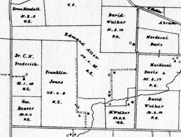
Edmund Allen |
2/15/1883 |
117a 35.81p |
$13,500 |
R9-464 |
Edmund Allen |
|
1883 |
117a |
|
Breou’s atlas |
Edmund Allen |
David Abraham |
4/10/1891 |
117a 35.81p |
|
Z10-103 |
David Abraham |
Daniel Abraham |
2/23/1897 |
|
|
Estate #25486 |
Daniel Abraham |
R. Francis Wood |
10/8/1903 |
116.969a |
|
I12-502 |
R. Francis Wood |
Frank Thomson |
3/1/1912 |
116.969a |
|
H14-337 |

Extract from Mueller’s 1912 atlas
|
Trustees of Frank Thomson |
Edward Law |
10/14/1943 |
118a 8p + 116.969a + 53a 59p |
$65,000 |
H21-39 |
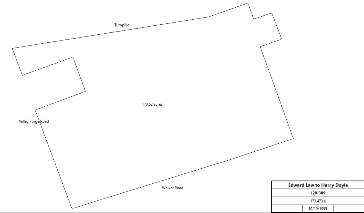
Edward Law |
Harry Doyle |
10/10/1955 |
173.473 |
$375,000 |
L28-309 |
L28-309
|
Edward Law |
PA Turnpike Comm. |
7/16/1961 |
91¾a |
$1 |
Q23-364 |
PA Turnpike Comm. |
Comm. of PA |
4/8/1963 |
19.71a |
land swap |
G35-257 |
PA Turnpike Comm. |
Comm. of PA |
9/3/1963 |
5.79a |
$11,200 |
K35-258 |
|
|
Y-310 Beginning at an elm tree in a line of John Beever’s land, thence by land of Jacob Walker N63°E 47.5p to a post, thence by the same land N25°W 38p to a stake, thence by the same land S63°W 27.3p to a parcel of stones, thence by the same land N25°W 75.5p to a post in a line of Abijah Stephen’s land, thence by the same land S65°W 42.7p to a large black oak., thence by the same N25°W 57p to a stake, thence by the land of John Havard S65°W 183.5p to a black tree in the line of land of Samuel Brown, thence by said land and land of John Havard S75°E 22.2p along the Baptist road to a heap of stones, thence by land of John Beever N65°E 144p to a stake near a large white oak, thence by the same S27°E 125.3p to a Mulberry Tree, thence by the same N65°E 60.5p to a sassafras tree, thence by the same S27°E 18.1p to the place of beginning. 96a 69p
|
Table E.1.2.1 Little Place Farm (Poor’s Quarters)
|
From |
To |
Date |
Area |
Cost |
Reference |
|
|
|
|
|
|
Benjamin Jones |
Benjamin Jones (g. son) |
1815 |
|
|
Will of Benjamin Jones |
Benjamin Jones |
Joseph Jones (father) |
|
|
|
Died; quoted in A5-206 |
Joseph Jones |
Widow & children |
|
|
|
Died; quoted in A5-206 |
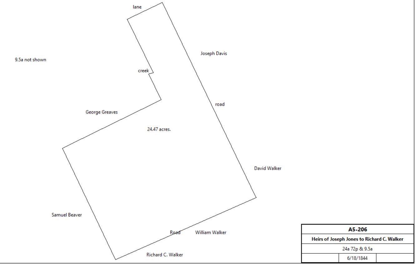
Heirs of Joseph Jones (Eleanor, John, Joseph, George R. Jones) |
Richard C. Walker |
6/18/1844 |
24a 72p & 9.5a |
$2400 |
A5-206 |
A5-206
|
Howard Walker & Elijah Pennypacker, executors of the will of Richard C. Walker & heirs Sarah Ann Walker, widow of Richard C. Walker |
John Groff & Morris Freeman |
4/1/1873 |
6a |
$390 |
K8-216 |
Estate of Richard Walker |
|
1873 |
|
|
Witmer’s Atlas |
M. Walker |
|
1883 |
24a 3r |
|
Breou’s Atlas |
Breou's Atlas - Thomas Road area
|
John S. Walker, Athalia Kendall, Matthias P. Walker, Winfield & Anna Walker, James & Anna McFarland; heirs of Matthias P. Walker |
Nathan R. & Sarah E. Walker |
4/4/1912 |
24a 72p |
$8,500 |
Q14-246 |
Norristown- Penn Trust Co., executor of the will of Nathan R. Walker and Sarah E. Walker |
Joseph & Louise McCready |
3/23/1944 |
24a 72p |
$17,500 |
S21-45 |
Louise McCready |
Frederick & Lura Wampler |
8/27/1971 |
not quoted |
$60,000 |
D40-327 |
Wampler family trust |
|
|
|
3.9a |
quoted in Chester County GIS system, 9/18/2023 |
|
Table E.2 John Roberts, later Godfrey - Dewees Property
|
From |
To |
Date |
Area |
Cost |
Reference |
|
|
|
|
|
|
John Kinsey |
John Roberts |
2/10/1702-3 |
265a, part of 539a |
|
Deed plan; Taylor papers reel 3. In tax record 1718 – 1732. |
John Roberts |
James Abraham |
Between 1715 - 1718 |
125a |
|
Unrecorded. See Table E.2.1 and deed plan; Taylor papers reel 3. |
John Roberts |
Thomas Godfrey |
5/13/1728 |
154a |
|
|
Thomas Godfrey |
William Godfrey |
12/15/1755 |
|
|
Will, see table P |
William Godfrey |
George King |
|
2a |
|
|
William Godfrey |
|
1760 |
225a |
|
Tax |
William Godfrey |
|
1765 |
220a |
|
Tax |
William Godfrey |
|
1767 |
200a |
|
Tax |
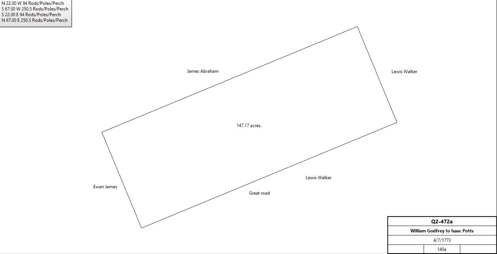
William & Hannah Godfrey |
Isaac Potts |
4/7/1773 |
140a + 150¾a (see table P.5) |
£1,900 |
Q2-472 |
 |
Isaac & Martha Potts |
William Dewees |
11/17/1773 |
140a |
£1,500 |
S2-65 |
William & Sarah Dewees |
|
11/18/1773 |
|
£600 |
Phila. Mortgage X-41 (with Philadelphia Contributionship for the Insurance of Houses from loss by fire) |
Potts & Dewees |
|
1779 |
100 or 106a |
|
County tax |
Potts & Dewees |
|
1781 |
140a |
|
County tax |
William Dewees |
|
1785 |
265a |
|
1785 County tax |
Sheriff |
Thomas Waters |
5/28/1788 deed poll |
140a |
£200 |
Sheriff’s deed books 1-45; R2-252. Debt of £1500 2s to Thomas Waters and 72s damages & costs. Same description as Q2-472 |
Thomas Waters |
Thomas Dewees (grandson) |
|
|
|
Will dated 6/29/1794 |
Thomas Dewees |
|
1798 |
149a |
|
Glass tax |
Thomas Dewees |
John Miller |
2/15/1799 |
149½a 36p |
£500 + interest (remaining mortgage) & £2459 10s |
R2-249; see deed plan |
Rev. Ebenezer Dickey |
Helen Miller |
3/29/1815 |
|
$3,500 |
K3-444; release of legacy |
Rev. Ebenezer Dickey and Margaret Miller |
Helen Miller |
3/29/1815 |
|
$1 |
K3-445 |
Margaret Miller and the executors of the will of John Miller |
Hananiah Walker |
4/1/1815 |
|
|
K3-443; release and assignment of dower |
Helen Miller, of Philadelphia, daughter and of John Miller |
Hananiah Walker of Easttown |
4/1/1815 |
149½a 36p |
$29,900 |
K3-442 |
|
|
Q2-472 Beginning at a white oak in the great road, thence by land of Ewan James NNW 94p to a post, thence by James Abraham’s land WSW 250½ perches to a post, thence by Lewis Walker’s land SSE 94 perches to a post, thence along said road by land of Lewis Walker ENE 258½ (250½) perches to the beginning. 140 acres.
Beginning by a post in the Lancaster great road thence by George King’s land N26°W 134 perches to a stone in the line of Samuel John’s land, thence by the same N63¼°E 45 perches to a stone, thence partly by Samuel John’s land and partly by Jacob Frick’s land N64°E 135 perches to a stone, thence by Ann George’s land S27°E 40 perches to a stone, thence by John Butler’s land S65°W 21 perches to a chestnut, thence partly by said John Butler’s land and partly by Whitehead Weatherly’s land S25¼°E 99 perches to a post in the Lancaster road, thence along the road West 31 perches to the beginning. 152¾ acres.
S2-65 Bounded by Great Road, Land of Evan Jones, James Abraham, Lewis Walker. 140a part of 265a John Kinsey sold to John Roberts etc.
R2-249 Messuage, Plantation, & tract. Beginning at a white oak in the great road, leading to the King of Prussia, thence by land of John Britton N27°30’W 98.35 perches to a stake, thence by Waters Dewees’ land S62°30’W 262.1 perches to a stake in the road leading to the Valley Forge, thence by the said road & along land of Benjamin Jones S27°30’E 84.5 perches to the middle of said great road, thence along said road by land of Joseph Walker N65°E 263.5 perches to the beginning.
|
Table E.2.1. James Abraham - Waters Dewees plot
|
From |
To |
Date |
Area |
Cost |
Reference |
|
|
|
|
|
|
John Roberts |
James Abraham |
|
125a |
|
Unrecorded. See table E.2 and deed plan; Taylor papers reel 3. |
James Abraham |
|
1718 - 1732 |
|
|
In tax records and mentioned in other deeds. This is probably the property eventually inherited by Waters Dewees. |
? |
Thomas Waters |
|
|
|
Unrecorded |
Thomas Waters |
Waters Dewees (grandson) |
|
|
|
Will dated 6/29/1794 |
Waters Dewees |
|
1798 |
124a |
|
Glass tax |
John Miller of Philadelphia |
Waters Dewees |
2/16/1799 |
|
25c |
R2-360; water rights |
Waters & Ann Dewees |
Mordecai & Joseph (son) Davis |
4/2/1821 |
127¼a + 46¼a (Upper Merion, see below) + 9a |
$14, |
S3-247 |
|
|
Table E.b.1 Upper Merion woodlot
|
From |
To |
Date |
Area |
Cost |
Reference |
|
|
|
|
|
|
Thomas Waters |
Waters Dewees |
|
29a |
|
will |
Thomas Waters |
Waters Dewees |
7/9/1795 |
10a |
|
Mont. 9-298 |
John Britton |
Waters Dewees |
1/12/1813 |
10a |
|
Mont. 32-430 |
|
Table E.b.2 Tredyffrin woodlot
|
From |
To |
Date |
Area |
Cost |
Reference |
|
|
|
|
|
|
Dennis & Mary Whelen |
Waters Dewees |
4/4/1797 |
9a |
|
R2-358 |
Dennis & Mary Whelen |
Waters Dewees |
|
|
|
R2- water rights |
|
|
S3-247 #1 Beginning at a post in a public road, in a line of Stephen Stephen’s land, thence by Stephens & others N63¾°E 260.2 perches to a post in the Montgomery county line, thence along said line S29°E 74.7 perches to a corner of Hannaniah Walker’s land, thence by said S62¼°W 260 perches to a post in a public road, in a line of Sacy Jones, thence along said road by lands of Sacy & Charles Jones N27½°W 81.4 perches to the place of beginning. 127¼a
#2 Upper Merion wood lot of 46¼a, composed of 3 adjoining plots: see table e.b.1
#3 Tredyffrin woodlot: Beginning at a post and by land of Joseph Conard N62½°E 27 perches to a post, and by land of Isaac Walker N27½°W 56 perches to a post, and by Henry Zook’s land S80°W 19.3 perches, and S21°E 63 perches to the place of beginning. 9a. see table e.b.2
|
