|
Note: in these deed histories distances are quoted in perches (p) of length 16.5 feet. Areas are quoted in acres (a) and square perches (p). There are 160 square perches to an acre. In a few cases roods (a quarter of an acre) are also used.
|
|
|
From |
To |
Date |
Area |
Cost |
Reference |
|
|
|
|
|
|
Commissioners of Penn |
Hugh Roberts |
4/5/1688 |
200a |
|
100a for use of Catherine Thomas. Not executed. Request for survey D69-160. |
Commissioners of Penn |
Thomas & Cadwallader Jones |
2/23/1702 (warrant) |
100a |
|
On right on mother, Catherine Thomas; see plan. Warrant in survey book D89-7. Patent not found. |
Thomas & Cadwallader Jones |
Rowland Richards |
1/14/1712 |
100a |
|
|
Owen Roblyn |
|
1722 |
|
|
County tax |
Rowland & Sarah Richards |
Owen Robbin or Roberts |
2/1/1723 |
100a |
|
See Taylor papers (reel 3) description of tract |
Owen Roblin |
|
1725 |
|
|
County tax |
Owen Roblin |
|
1726 |
|
|
County tax |
|
Owen Robbins |
8/13/1726 |
|
£50 |
Debt recovered by Evan Hugh & Peter Elliott (from D-353) |
Sheriff (Owen Robin) |
Richard Iddings |
4/27/1727 |
100a |
£51 |
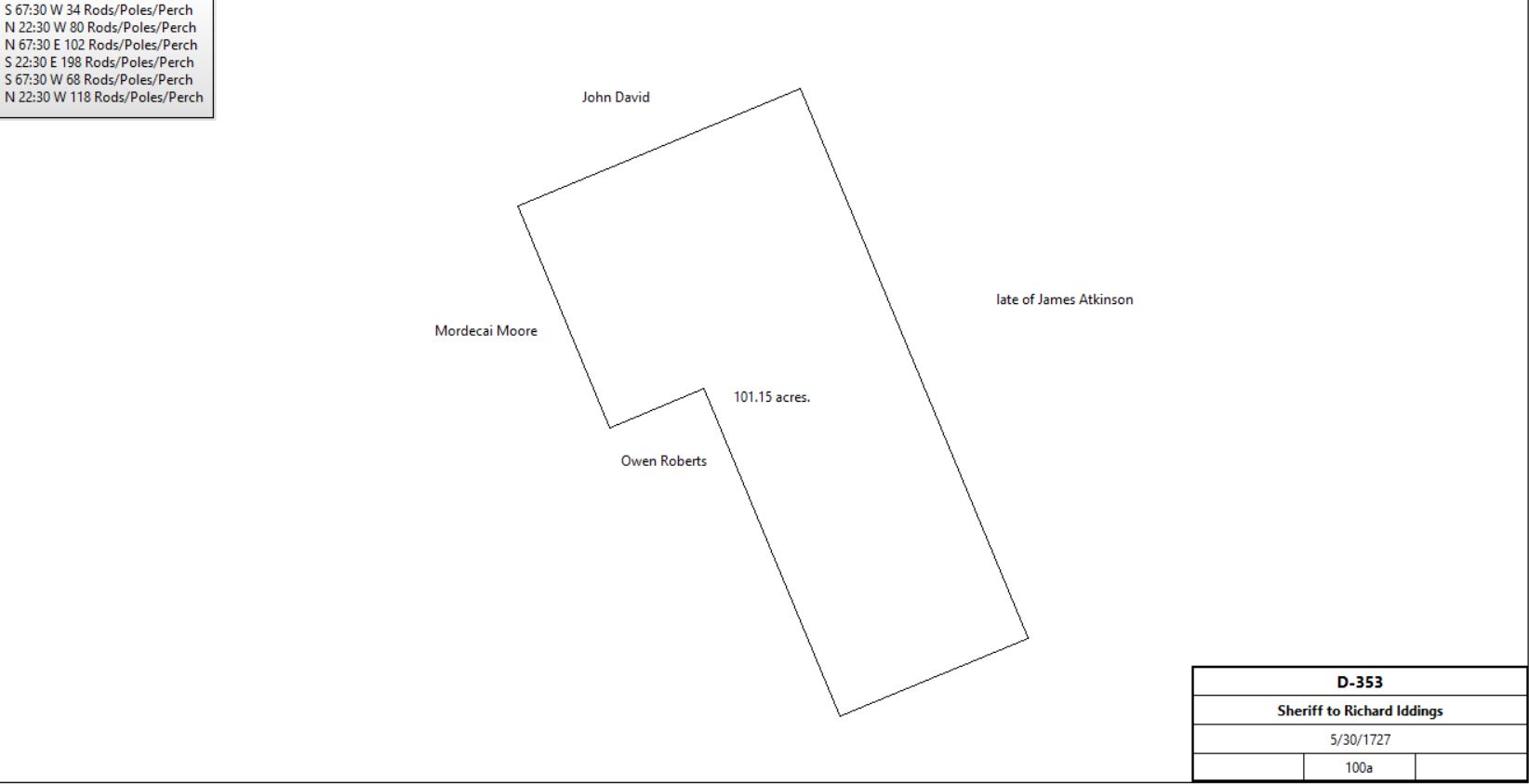
D-353; Messuage. See deed plan (same as quoted in X-34); neighbors Owen Roberts, Mordecai Moore, John David, late of James Atkinson |
 |
|
|
1744 |
|
|
Plantation with a house. Advertisement in the Pennsylvania Gazette |
Richard Iddings |
Elizabeth Wayne (daughter) |
3/16/1753 |
100a |
|
Will |
Isaac & Elizabeth Wayne |
Thomas Williams |
11/28/1764 |
2a |
£10 |
X-34; see deed plan and table Z.2 |
Isaac & Elizabeth Wayne |
John Robinson |
|
4½a + messuage |
|
See table Z.1 |
Isaac & Elizabeth Wayne |
John Hampton |
> 1813 |
1a |
|
See table Z.1 |
Excrs. of Elizabeth Wayne |
David Wilson |
5/1/1794 |
100a |
£650 |
K2-263; see deed plan |
David & Sarah Wilson |
John Christie |
1/7/1795 |
15a 36p |
£130 18s 8d |
O2-371; see table Z.5 |
John Christie |
Isaac Vanleer |
5/31/1797 |
5a 12p |
£104 10s 10d |
R2-74; see deed plan |
John Christie |
John Brown |
|
10a |
|
Deed not found; mentioned in deed R2-74; |
David & Sarah Wilson |
John Davis |
6/10/1794 |
10a |
£86 |
K2-436 |
David & Sarah Wilson |
Henry Zook |
7/18/1794 |
34a |
£127 10s |
N2-265 |
Henry Zook |
Martin Potter |
3/24/1797 |
60a |
£541 |
P2-99; see table Z.6 |
David & Sarah Wilson |
William Downey |
10/1/1798 |
30a |
£225 |
S2-271; see table Z.3 |
David Wilson |
|
1798 |
18a |
|
Glass tax; hill land, neighbor William Downey |
John Davis |
|
1798 |
10a |
|
Glass tax; hill land, neighbor William Downey |
William Downey |
|
1798 |
30a |
|
Only in glass tax as tenant but deeds showed he owned the land |
John Brown |
|
1798 |
10a |
|
Glass tax; hill land |
Martin Potter |
|
1798 |
60a |
|
Not in glass tax for Tredyffrin; perhaps he was in Easttown return (where he lived) |
David Wilson senior |
|
1828 |
|
|
died |
David Wilson junior and Joseph Caskey, executors of the will of David Wilson senior |
Edward Siter |
4/4/1829 |
112a + 18a |
$9,599 |
C4-113 |
Edward & Sarah Siter |
David Wilson junior |
6/12/1829 |
112a + 18a |
$9,599 |
C4-114 |
W.S. Wilson |
|
1883 |
7a 38r 33p |
|
Breou’s Atlas |
C. Colket Wilson |
|
1912 |
7a 38r 33p |
|
Mueller’s Atlas |
John M. Wilson |
|
1883 |
7a 1r 14p |
|
Breou’s Atlas |
David Wilson |
|
1912 |
7a 1r 14p |
|
Mueller’s Atlas |
|
|
D-353 Deed. On 27 Apr 1727 John Taylor, High Sheriff, to Richard Iddings Whereas Evan Hugh, yeomen, in the court of Comm Pleas did recover of Owen Robin, late of county of Chester, as well; £50 of debt 72 shillings and 6 pence were adjudged for damages. Land of Owen Robin was seized and for £51 granted to Richard Idding of Chester county, yeoman, a tract in Treduffin in county of Chester bounded by land of Owen Roberts, Mordecai Moors land, John David & land late of late James Atkinson, containing 100 acres. Signed John Taylor. Delivered in the presence of William Seymour & Alexander Ogle. Recorded 30 May 1727. (D[4]:353).
X-34 Cites: Beginning at a hickory tree, a corner of Owen Robert’s land, thence by said land WSW 34 perches to a hickory, thence NNW by Mordecai Moore’s land 80 perches to a post, thence ENE by John David’s land 102 perches to a post, thence SSE by land of James Atkinson 198 perches to a white oak, thence WSW 68 perches to a post, thence by Owen Robert’s land NNE 118 perches to the place of beginning.
This indenture: Beginning at a stone in the Philadelphia-Lancaster road, a corner of William Sharp’s land, thence S65¾°W along said road 20 perches to another stone in the said road for a corner, thence N24½°W by other land of Isaac Wayne 32 perches to a third stone in the road from the Lancaster road to the valley, a corner of Benjamin Robinson’s land, thence S55½°E by said Robinson’s land Sharp’s land 37¾ perches to the place of beginning.
|
|
Table Z.1 Neilley Cabin
|
From |
To |
Date |
Area |
Cost |
Reference |
|
|
|
|
|
|
Isaac & Elizabeth Wayne |
John Robinson |
|
4½a + messuage |
|
|
John Robinson |
|
1775 |
|
|
died |
Heirs of John Robinson (Isaac Connelly and his wife Rebecca Robinson Connelly of New Providence Township,
Samuel Garrigues Jr., a merchant of Philadelphia who owned other land in
Tredyffiin, and Richard Robinson, an Innkeeper of Willistown |
James Neilley |
3/14/1780 |
4½a |
£1500 (seems a huge amount of money but that is due to inflation in the war) |
L3– 480. neighbors Daniel Watkins, William Sharps, Bascom Ringer, Isaac Van Leer and Abraham Watters or Walters |
James Neilley |
|
1798 |
8a |
|
Glass tax. Tenant William Downy. Log cabin 28’ x 18’, log shop 24’x15’ |
James Neely |
|
1799 |
4a |
|
Tax. Tenant William Downy, weaver |
John & Lydia Hampton |
James Neilley |
4/14/1813 |
1a |
$159.50 |
L3(59)-481; see deed plan |
James Neilley |
John Neilly |
|
|
|
Died intestate |
John Neilly |
|
|
|
|
Died intestate |
William Wayne, trustee |
James McFadden |
3/28/1881 |
4a 84p |
$708 |
L9-51 |
James & Annie McFadden |
Eugene Hornbrook & Michael Bogan |
7/3/1882 |
4a 84p |
$2500 |
P9-336 |
Michael & Kate Bogan |
Eugene Hornbrook |
1/14/1884 |
4a 84p |
$1 |
U9-478 |
Eugene Hornbrook |
Jacob Hornbrook |
6/13/1884 |
4a 84p |
$2210 |
Mortgage J3(68)-8 |
Sheriff |
Jacob Hornbrook |
10/28/1886 |
4a 84p |
$200 |
Sheriff’s deed 9, 287 |
|
|
Table Z.2
|
From |
To |
Date |
Area |
Cost |
Reference |
|
|
|
|
|
|
Isaac & Elizabeth Wayne |
Thomas Williams |
11/28/1764 |
2a |
£10 |
X-34; see deed plan |
Thomas & Jane Williams |
Paschall Davis |
4/17/1780 |
2a |
£43 |
X-36 |
Paschall Davis |
Llewelyn Davis |
12/10/1780 |
2a |
£40 |
X-37 |
Llewelyn Davis |
Ann Smith |
7/25/1791 |
|
|
Cockletown by Franklin Burns |
Ann Smith |
Abel Reese |
7/26/1791 |
|
|
|
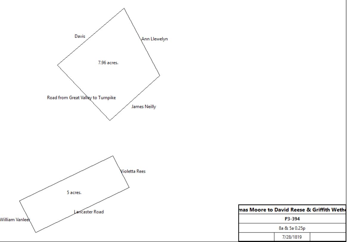
Abel Reese |
Violotta Reese |
1/8/1792 |
|
|
Will wife Vilotta Reese my house and lott of land sit. On Old Lancaster Road, called Corner Lott. (NW corner of Conestoga and Howellville Road) |
Violotta Reese |
David Reese |
9/21/1820 |
|
|
Will |
|
|
Table Z.3 Doyle’s Nursery Area
|
From |
To |
Date |
Area |
Cost |
Reference |
|
|
|
|
|
|
David & Sarah Wilson |
William Downey |
10/1/1798 |
30a |
£225 |
S2-271; see deed plan |
William Downey |
Thomas Moore |
4/1/1814 |
30a |
|
L3-83 |
Thomas & Mary Moore |
David Rees & Griffith Wetherby |
7/28/1819 |
8a & 5a 0.25p |
$100 |
P3-394 |
 |
David Rees |
Griffith Wetherby |
1/23/1823 |
17a |
|
Release; not found |
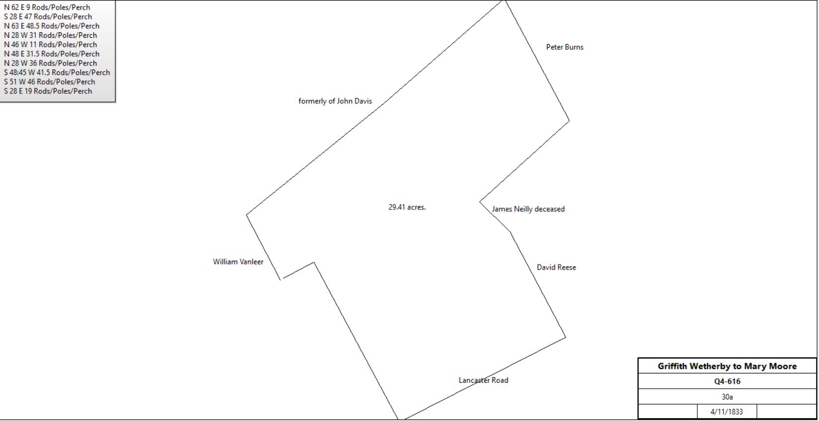
Griffith Wetherby |
Mary Moore |
4/11/1833 |
30a |
$5 |
Q4-616 |
 |
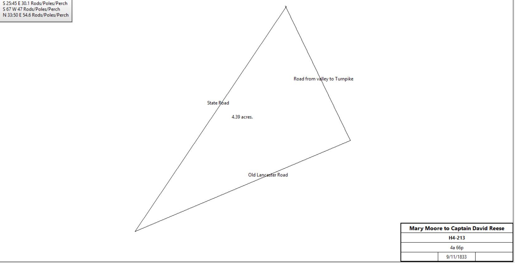
Mary Moore |
Captain David Reese |
9/11/1833 |
4a 66p |
$70 |
H4-213 (part of 30a) |
 |
Mary Moore |
Richard Evans |
5/4/1839 |
25a 94p |
$1400 |
W4-273 (part of 30a) |
Richard Evans |
|
1883 |
50a |
|
Breou’s Atlas |
William H. Doyle |
|
1912 |
76a 99p |
|
Mueller’s Atlas; looks like same boundaries as Evans on map |
M. Morrison |
|
1883 |
6a 1r 30p |
|
Breou’s Atlas; between Old State & Conestoga Road |
Matilda Morrison |
Howard S. Okie |
1907 |
|
|
Y11-286 |
Matilda Morrison |
Francis G. Okie |
1907 |
|
|
Y11-287 |
Francis G. Okie |
|
1912 |
4.75a |
|
Mueller’s Atlas |
Howard S. Okie |
|
1912 |
2.5a? |
|
Mueller’s Atlas |
Francis Okie |
Richard Macnamee |
1908 |
|
|
O13-112 |
Macnamee estate |
|
1933 |
|
|
atlas |
S. Paul Teamer |
|
c. 1938 |
|
|
|
|
|
Table Z.4 Berwyn; Conestoga Road to Easttown Boundary
|
From |
To |
Date |
Area |
Cost |
Reference |
|
|
|
|
|
|
John Brooke |
Henry Fritz |
4/1/1863 |
|
|
U6-344 |
Ann Potter, William Atlee Potter, Sarah A.D. Potter |
Henry Fritz |
3/31/1869 |
|
|
R7-134 |
Hugh Steen (guardian of the Fritz children, Hugh & Mary Steen |
Pennsylvania Railroad |
9/22/1877 |
0.682 & 0.969 acres |
|
X8-514 |
Mrs. Steen |
|
1883 |
|
|
Breou’s Atlas; south of Conestoga Road |
William H. Fritz |
|
1912 |
|
|
Mueller’s Atlas |
Easttown & Tredyffrin High School |
|
1912 |
|
|
Mueller’s Atlas |
|
Table Z.5 West-side Irish Road
|
From |
To |
Date |
Area |
Cost |
Reference |
|
|
|
|
|
|
David & Sarah Wilson |
John Christie |
1/7/1795 |
15a 36p |
£130 18s 8d |
O2-371 |
John Christie |
Isaac Vanleer |
5/31/1797 |
5a 12p |
£104 10s |
R2-74 |
William Vanleer |
|
1833 |
|
|
Named in description in Q4-616 |
|
|
|
|
|
|
John Christie |
John Brown |
|
10a |
|
Deed not found; mentioned in deed R2-74 |
John Brown |
|
1797 |
10a |
|
Tax on 218a in total; 10a hill land |
John Brown |
|
1798 |
10a |
|
Tax 237a |
John Brown |
|
1798 |
10a |
|
Glass tax; 226a; 8a + 10a hill land |
John Brown |
|
1799 |
218a |
|
Tax |
John Brown |
|
1801 - 19 |
|
|
Hill land in tax record |
Adam Snyder |
|
1814 - 19 |
10a |
|
Taxes |
John Brown |
|
1820 |
|
|
Valley land only in tax record (118a) |
Adam Snyder |
|
1820 -22 |
28a |
|
taxes |
John Brown |
|
1823 |
|
|
Died |
Adam Snyder |
|
1823 - 25 |
35a |
|
taxes |
Adam Snyder |
|
1830 |
42a |
|
taxes |
Adam Snyder |
|
1831 |
35a |
|
Taxes (last entry for Adam Snyder in Tredyffrin tax records) |
Adam Snyder |
|
9/22/1837 |
|
|
Died. Will proved 12/30/1837. Will gives property to children after wife’s death. |
|
|
|
|
|
|
Edward & Mary Parker |
John Reese |
6/28/1828 |
14a |
$3450 |
A4-493; deed poll |
Thomas Snyder |
|
1850 |
23a |
|
Agricultural Census |
|
|
|
|
|
|
Heirs of Adam Snyder |
Dorothy Ann Hopkins |
? |
2a |
|
Z9-446 part of 14a 6p John G. Bull and John Davis to Adam Snyder (deed not found) – see table AN.2.1 |
Heirs of Adam Snyder |
Patrick F. Foy |
3/31/1857 |
23a 3r 5p |
$1498 21c |
F6-63; see deed plan |
Sheriff |
John C. Richardson |
|
|
|
Sheriff’s deed #6, 441 |
John C. Richardson ux |
William Glenn |
2/1/1868 |
23a 3r 5p |
$1675 |
K7-199 |
|
|
|
|
|
|
Dorothy Ann Hopkins |
William Glenn |
3/14/1879 |
2a |
$550 |
D9-149 |
William Glenn |
|
1883 |
27a |
|
Breou’s Atlas |
William Glenn |
|
7/2/1884 |
|
|
Died; will dated 1/18/1884 |
Henry Heyburn & Robert Glenn (exrs. Of William Glenn) |
Henry H. Taylor |
7/7/1885 |
28.374a |
$4,000 |
Z9-448; through Margaret McConnell who bought and sold. Made up of 3 tracts: K7-199, R8-27, D9-149 |
Harry Taylor |
|
1887 |
|
|
Atlas |
Harry Taylor |
|
1900 |
28+a |
|
Atlas |
Harry H. Taylor |
|
1912 |
28.374a |
|
Atlas |
Harry H. Taylor |
|
1920 |
28.374a |
|
Atlas |
Miss Atlee |
|
1926 |
28.374a |
|
Atlas |
Clara & Alice Atlee |
|
1933 |
28.374a |
|
“Cabin Dale”, Atlas |
Clara & Alice Atlee |
|
1950 |
28.374a |
|
Atlas |
Wetherby – Hampton – Snyder – Wilson – Erdman Cabin |
|
present |
|
|
251 Irish Road. 2003 Historic Resources Survey of Tredyffrin Township, p. 209 |
|
|
Table Z.6 Henry Zook land around Lancaster Turnpike
|
From |
To |
Date |
Area |
Cost |
Reference |
|
|
|
|
|
|
|
Morris Morris |
2/27/1788 |
106a |
|
Acknowledged Court of Common Pleas, 3/12/1789 |
David & Sarah Wilson |
Henry Zook |
7/18/1794 |
34a |
£127 10s |
N2-265 |
Morris & Ruth Morris |
Henry Zook |
4/8/1795 |
31a |
£200 |
N2-263; see deed plan |
Henry Zook |
Martin Potter |
3/24/1797 |
60a |
£541 |
P2-99; see deed plan |
Martin Potter |
|
1798 |
60a |
|
Partially in Easttown. Not in glass tax for Tredyffrin; perhaps he was in Easttown return (where he lived) |
Mary Potter et al |
William Neill |
3/21/1814 |
10a |
$340 |
K3-104; part of P2-99; mentions house |
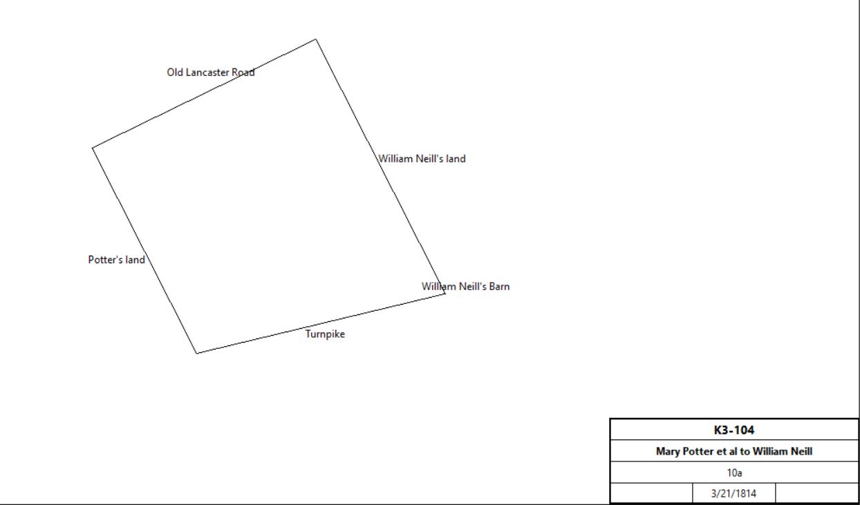
K3-104 plan
|
Martin Potter et al |
Joseph Potter |
1/14/1816 |
44a 60p |
$3106 25c |
N3-336; part of P2-99 |
Margaret Neill et al, Excrs of William Neill |
Edward Parker |
3/28/1821 |
14a |
$1000 |
W3-285; see deed plan. Between Old Lancaster Road & Turnpike |
Edward Parker |
James Fassit |
1/31/1822 |
14a |
|
|
James Fassit |
Richard Harding |
2/19/1822 |
14a |
|
W3-288 |
Richard Harding |
John Reese |
|
|
|
Deed poll |
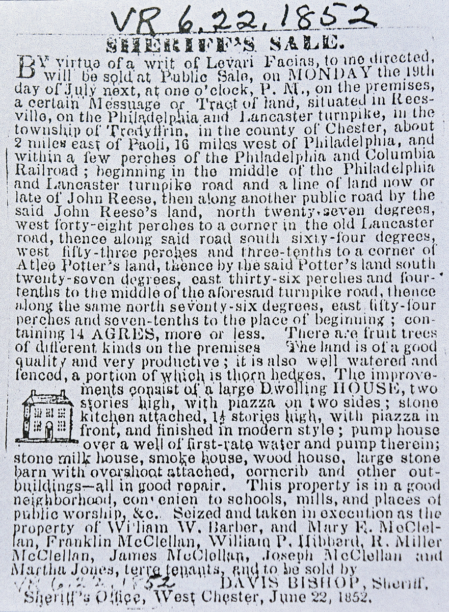
Sheriff, Joseph Taylor, debt of John Reese |
William Barber |
2/16/1838 |
14a. Neighbors Atlee Potter, Henry Carter, and the Valley Road |
$2,825 |
Sheriff’s deed 4-202 |
|
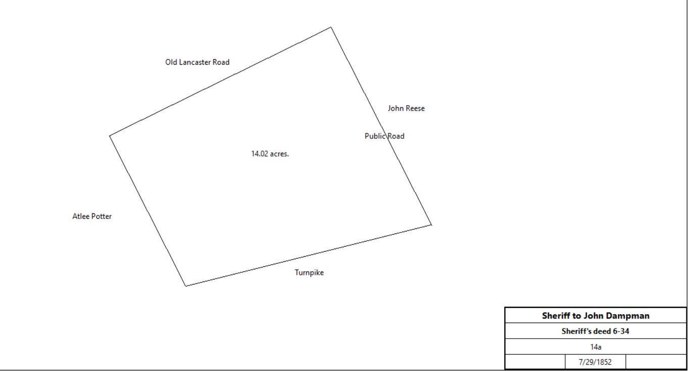
Sheriff, David Bishop, debt of William Barber |
John Dampman |
7/9/1852 |
14a |
$1,725 |
Sheriff’s deed 6-34 |
 |
William Moore |
|
1871 |
|
|
tax return |
Mrs Margaret Moore |
|
1873 |
|
|
Witmer’s atlas |
Margaret Moore |
|
1876 |
|
|
died intestate |
William Moore |
|
1878 |
|
|
died |
Charles Moore |
|
1883 |
|
|
Breou’s Atlas; south of Conestoga Road |
Charles Moore |
|
1900 |
14a |
|
Atlas |
Charles Moore |
|
1903 |
14a |
|
died |
John Beadle |
|
1908 |
14a |
|
Atlas |
John H. Beadle |
|
1912 |
8.242a |
|
Mueller’s Atlas |
John H. Beadle |
|
1920 |
8.242a |
|
Mueller’s Atlas |
Mrs. John H. Beadle |
|
1926 |
8.242a |
|
Bromley’s Atlas |
E. J. Beadle plan |
|
1933 |
|
|
Atlas |
Mildred Bradley |
|
c. 1938 |
|
|
|
Helen Ainge (trust), Charles J. Bradley (estate), Leroy Fisher (trust), Mildred F. Fisher (estate), Majorie Pritchard (trust) |
Joe & Judith Watt |
9/5/1978 |
|
|
Tract #43; P53-255 |
Joe & Judith Watt |
John Luquer & Peter Zimmerman |
8/27/1984 |
|
|
E64-113 |
John Luquer and Peter Zimmerman |
Peter & Elizabeth Zimmerman |
12/30/1993 |
|
$175,000 |
#43 lot, Old Lancaster Road; Book 3696-1068 |
|
|
Table Z.7 Land between Turnpike and Railroad
|
Mary A. Lewis tract (Tredyffrin & Easttown) |
From |
To |
Date |
Area |
Cost |
Reference |
|
|
|
|
|
|
See Mary A. Lewis tract in the Easttown deed histories for the earlier history of the tract |
William McClary, executor of the will of Ann Carter |
Mary A. Lewis |
2/28/1877 |
38a 53.49p (Tredyffrin & Easttown) + 1a 10.4p (Tredyffrin) |
$3,400 |
V8-475 |
Lot, stores, and warehouse |
From |
To |
Date |
Area |
Cost |
Reference |
|
|
|
|
|
|
Mary A. Lewis |
Gibbons Hickman |
10/1/1881 |
115p |
$800 |
M9-104 |
Gibbons & Salome Hickman |
Ann Ottey |
4/24/1885 |
115p |
$1,500 |
C10-66 |
Ann & Enoch Ottey |
Nellie Gibson |
12/10/1901 |
115p |
$2,150 |
H12-588 |
Nellie & Phenies Gibson |
Christopher McDonnell |
3/25/1908 |
150p |
$2,800 |
N13-366 |
Christopher McDonnell |
Catherine Walker |
4/30/1943 |
|
|
Bequest of part of the property; will book 58-464 |
Catherine & William Irwin Walker |
Angelo & Joseph D'Andrea |
6/23/1948 |
|
$8,500 |
Y23-65 |
Angelo D'Andrea |
Joseph D'Andrea |
4/17/1950 |
not quoted |
$1 |
Z24-11 |
Joseph D'Andrea |
Anthony & Serafina D'Andrea |
3/16/1956 |
not quoted |
$1 |
H27-340 |
Anthony & Serafina D'Andrea |
Joseph & Joan Leaming |
9/19/1957 |
not quoted |
$12,000 |
P29-527 |
Joseph & Joan Leaming |
Joseph Leaming |
5/6/1963 |
0.19a |
$1 |
D35-649 |
Joseph & Rosemarie Leaming |
P & O Properties |
4/21/2017 |
0.19a |
$500,000 |
9527-76 |
Robinson - Welburn Lodge |
From |
To |
Date |
Area |
Cost |
Reference |
|
|
|
|
|
|
Frederick J. Wahl, sheriff |
County of Chester |
6/30/1938 |
Various tracts including 0.126a |
$4,825 41c |
D20-300 |
E. Dean Stanton, Ira J. Oakes, and Franklin G. Evans, commissioners of the County of Chester |
Geoffrie Vause |
9/21/1939 |
0.126a |
$3,650 |
G20-238 |
Geoffrie & Jesse Vause |
Jesse Vause, Edgar Powell, Charles Shepherd, Frederick Garner, Morris White, William Harris, and Primus Crosby, trustees of Robinson Welburn Lodge #794, I.B.P.O.E. of W. |
11/25/1939 |
0.126a |
$1, and mortgage of $2,500 |
K20-42 |
Robinson Welburn Lodge? |
Eadah Family Limited Partnership |
3/12/2003 |
0.12a? |
$360,000 |
5606-46. Lodge Hall and lot, 901 Lancaster Avenue, Berwyn |
|
