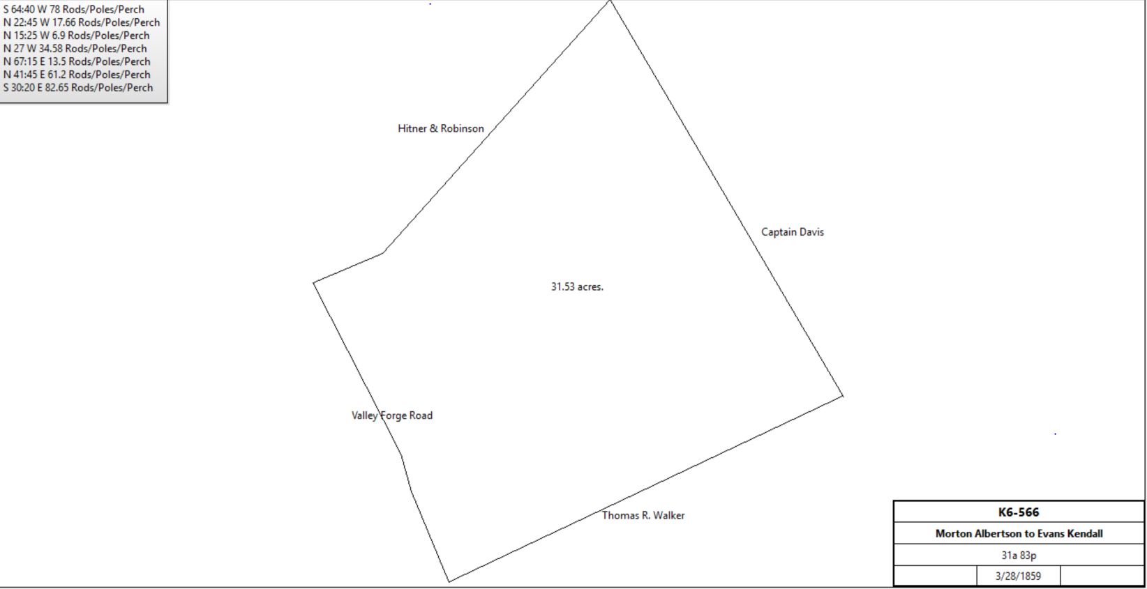
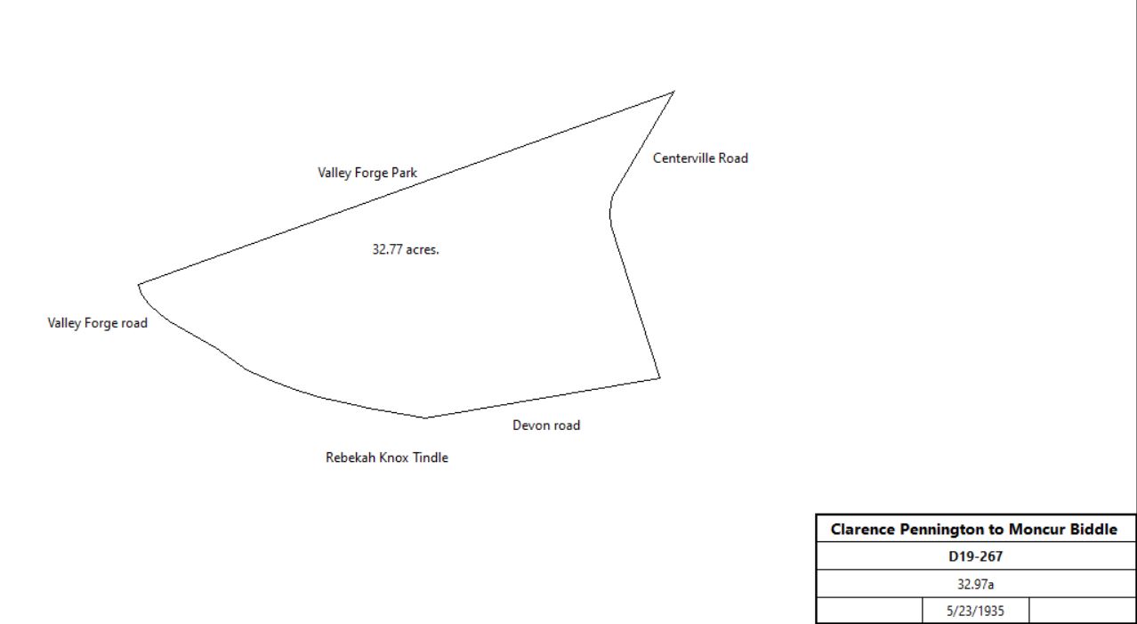
|
| Tredyffrin Easttown Historical Society Home : Tredyffrin History : Original Purchasers Map Use the links at left of the article to return. |
Tredyffrin History Digital ArchivesTable H - Henry John & Nathan Evans Purchases(Samuel Davis Farm) |
|
Note: in these deed histories distances are quoted in perches (p) of length 16.5 feet. Areas are quoted in acres (a) and square perches (p). There are 160 square perches to an acre. In a few cases roods (a quarter of an acre) are also used. | ||||||||||||||||||||||||||||||||||||||||||||||||||||||||||||||||||||||||||||||||||||||||||||||||||||||||||||||||||||||||||||||||||||||||||||||||||||||||||||||||||||||||||||||||||||||||||||||||||||||||||||||||||||||||||||||||||||||||||||||||||||||||||||||||||||||||||||||||||||||||||||||||||||||||||||||||||||||||||||||||||||||||||||||||||||||||||||||||||||||||||||||||||||||||||||||||||||||||||||||||||||||||||||||||||||||||||||||||||||||||||||||||||||||||||||||||||||||||||||||||||||||
|
| ||||||||||||||||||||||||||||||||||||||||||||||||||||||||||||||||||||||||||||||||||||||||||||||||||||||||||||||||||||||||||||||||||||||||||||||||||||||||||||||||||||||||||||||||||||||||||||||||||||||||||||||||||||||||||||||||||||||||||||||||||||||||||||||||||||||||||||||||||||||||||||||||||||||||||||||||||||||||||||||||||||||||||||||||||||||||||||||||||||||||||||||||||||||||||||||||||||||||||||||||||||||||||||||||||||||||||||||||||||||||||||||||||||||||||||||||||||||||||||||||||||||
| ||||||||||||||||||||||||||||||||||||||||||||||||||||||||||||||||||||||||||||||||||||||||||||||||||||||||||||||||||||||||||||||||||||||||||||||||||||||||||||||||||||||||||||||||||||||||||||||||||||||||||||||||||||||||||||||||||||||||||||||||||||||||||||||||||||||||||||||||||||||||||||||||||||||||||||||||||||||||||||||||||||||||||||||||||||||||||||||||||||||||||||||||||||||||||||||||||||||||||||||||||||||||||||||||||||||||||||||||||||||||||||||||||||||||||||||||||||||||||||||||||||||
|
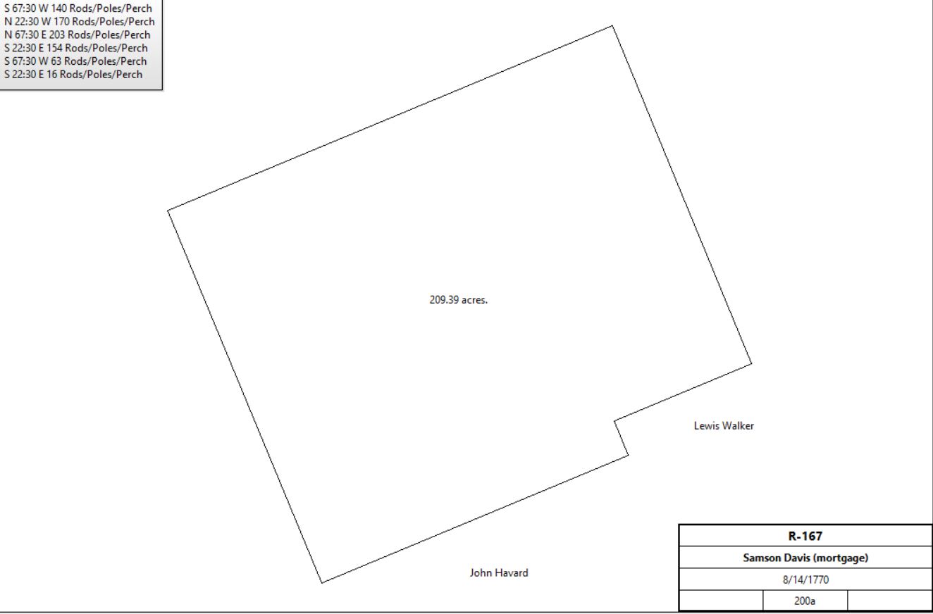
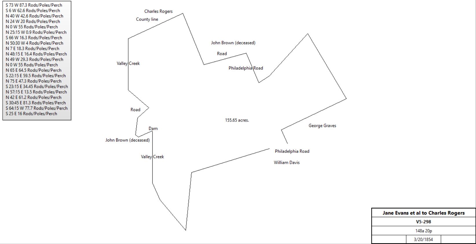
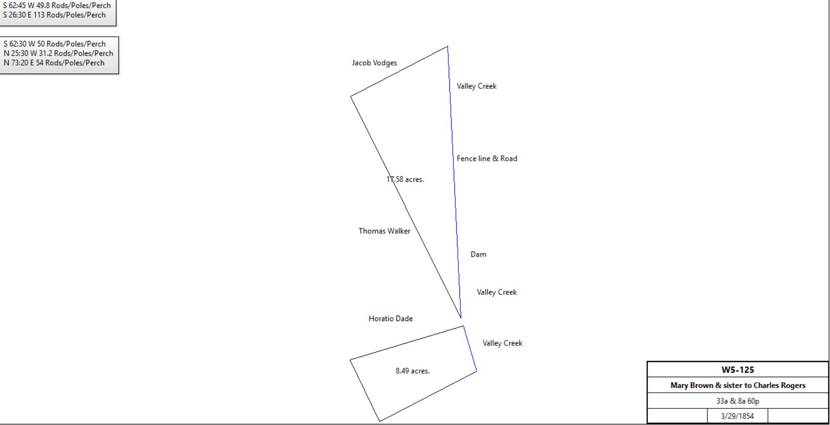
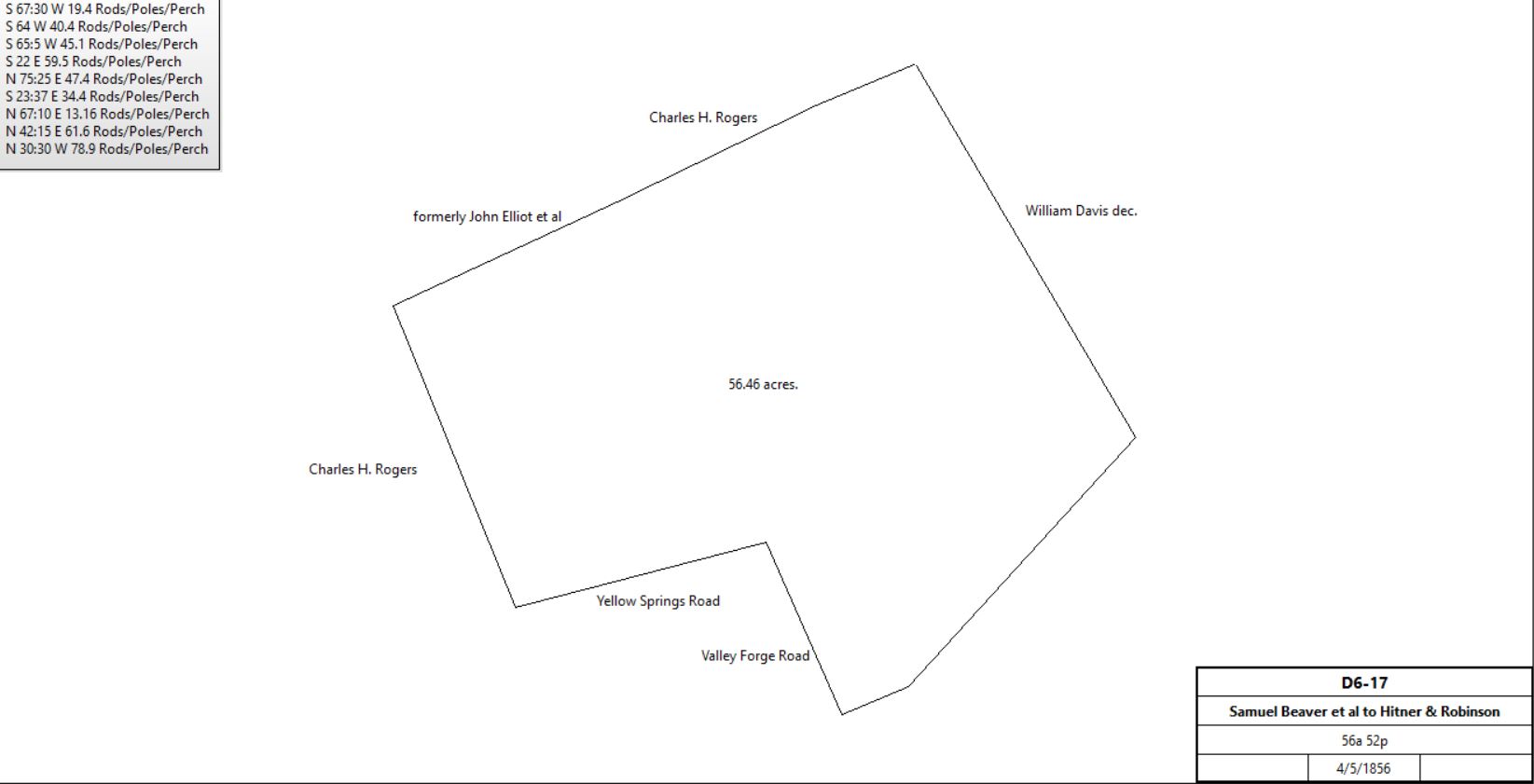
Pennsylvania Gazette 2/28/1769 TO BE SOLD. A valuable Plantation, situate in Tredyffrin township, Chester County, adjoining lands of John Havard, Rev. William Curry, and others, containing 100 acres, more or less, of good limestone land, with Conveniency of erecting Water Works, as the Valley Creek runs through the same. Any Person inclining to purchase the same, may apply to SAMUEL or THOMAS JONES, near the said premises and know the terms. Also the Plantation whereon the said Thomas Jones now lives. R-167 Beginning at a corner of John Havard’s land, thence by a line of marked trees and the same land WSW 140 perches to a post, thence by said Havard’s land and other land NNW 170 perches to a post, thence by vacant land ENE 203 perches to a post near a small hickory sapling, thence by reputed vacant land SSE 154 perches to a post in the reputed land of Lewis Walker, thence by same land WSW 63 perches to a post, being a corner of the reputed Lewis Walker’s land, thence SSE16 perches to the beginning. Pennsylvania Gazette: By order of the Orphan’s Court, on Friday, the 25th October instant, at 2 o'clock in the afternoon, will be exposed to sale by public vendue, on the premises, that valuable plantation, on which Samson Davis lately dwelt, situate in the township of Tredyffrin, in Chester county, adjoining lands of John Havard, Samuel Havard, the Rev. William Curry, and others, containing about 200 acres of extraordinary good- limestone land, about 100 acres cleared, the greatest part has been cleared within last five years, the remainder well timbered, about 20 acres of choice meadow may be made, with little expense, the timber being cut off, and part already in grass, and may all be watered, being so situated that the Valley creek, which runs through the plantation, may easily be turned over the whole; also a conveniency for erecting agrist mill, or any other water works, with plenty of water in the driest seasons. There are on the premises, a large new stone dwelling-house and kitchen, a stone spring-house over a spring of good water, also a log dwelling-house not quite finished, built over a large spring of excellent water, a log barn, stables etc. The purchaser on paying one half of the purchase money immediately, may have sufficient time for payment of the remainder, with interest, and giving security, if required. Z-176 Messuage, tenement, plantation. Bounded by Mount Joy road and lands of the late John Haverd, Lewis Walker, Samuel Havard, Nathan Evans and Daniel Walker. W5-129 Samuel Beaver & wife and Mary A. Brown to Charles H. Rogers Beginning at a Corner adjoining land late the property of Jacob Vodges and land of Thomas Walker thence by said Walkers land S26½ºE 113 perches to a Corner or to the Middle of Valley Creek thence down the middle of said creek several courses thereof to the breadth of the Dam thence leaving the said creek and extending along a ditch now made by several courses thereof to the Middle of a Road leading across the said creek thence along the middle of said road towards the creek so far as to be in a line with a post fence extending down the creek thence along said fence to where the spring run from John Brown Jr’s (?) dwelling crosses the said fence or where it empties into the creek thence down the middle of the Creek several courses thereof to the line of the late Vodges thence S62¾ºW 49.8 perches to the beginning.
| ||||||||||||||||||||||||||||||||||||||||||||||||||||||||||||||||||||||||||||||||||||||||||||||||||||||||||||||||||||||||||||||||||||||||||||||||||||||||||||||||||||||||||||||||||||||||||||||||||||||||||||||||||||||||||||||||||||||||||||||||||||||||||||||||||||||||||||||||||||||||||||||||||||||||||||||||||||||||||||||||||||||||||||||||||||||||||||||||||||||||||||||||||||||||||||||||||||||||||||||||||||||||||||||||||||||||||||||||||||||||||||||||||||||||||||||||||||||||||||||||||||||
Table H.1 Bean tracts | ||||||||||||||||||||||||||||||||||||||||||||||||||||||||||||||||||||||||||||||||||||||||||||||||||||||||||||||||||||||||||||||||||||||||||||||||||||||||||||||||||||||||||||||||||||||||||||||||||||||||||||||||||||||||||||||||||||||||||||||||||||||||||||||||||||||||||||||||||||||||||||||||||||||||||||||||||||||||||||||||||||||||||||||||||||||||||||||||||||||||||||||||||||||||||||||||||||||||||||||||||||||||||||||||||||||||||||||||||||||||||||||||||||||||||||||||||||||||||||||||||||||
| ||||||||||||||||||||||||||||||||||||||||||||||||||||||||||||||||||||||||||||||||||||||||||||||||||||||||||||||||||||||||||||||||||||||||||||||||||||||||||||||||||||||||||||||||||||||||||||||||||||||||||||||||||||||||||||||||||||||||||||||||||||||||||||||||||||||||||||||||||||||||||||||||||||||||||||||||||||||||||||||||||||||||||||||||||||||||||||||||||||||||||||||||||||||||||||||||||||||||||||||||||||||||||||||||||||||||||||||||||||||||||||||||||||||||||||||||||||||||||||||||||||||
|
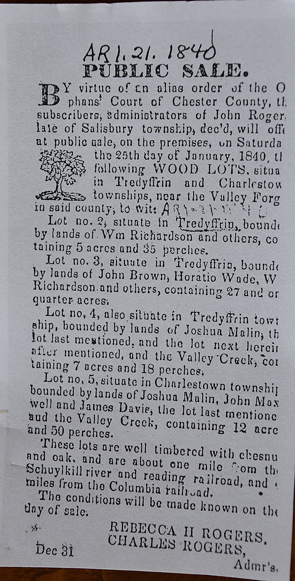
One of them in Tredyffrin. a) Beginning at a corner of land sold by assignees of the estate of John Rogers to William Hoffman, thence by the same N73º20’E 43.48 perches to a stone heap and stake at another corner of said land, thence by the next hereinafter described lot S17ºE 20 perches to a stone heap and stake, thence by land sold to William Richardson S73º20’W 40.7 perches to a stone and stone heap, and thence by land in dispute between said assignees and Thomas Walker N25 & 26ºW 19.9 perches to the place of beginning. b) In Tredyffrin. Beginning at a corner of land sold by the said assignees to John Brown at the edge of Valley Creek, thence by said land S73º20’W 20.3 perches to a stone and stone heap at a corner of land sold to Horatio Wade, thence by same N23½ºW 10.8 perches to a stone heap and stake, thence by land sold to Thomas Walker N10½ºW 23.06 perches to a hickory, thence by land sold to John Maxwell N42¼ºW 10.16 perches to a stake and stone heap at a corner of land sold to William Richardson herein before mentioned , thence N17ºW 72 perches to a stake and stone heap, thence by the herein after next described lot N73º20’E 56 perches to the edge of said Valley Creek, thence by same following the courses thereof to the place of beginning. c) Beginning at the edge of Valley Creek thence by the next preceding described lot S73º20’W 56 perches to a stake and stone heap, thence by the following herein described lot N73º20’E 43 perches to the edge of Valley Creek, and thence by edge of same following the courses to the place of beginning. In Schuylkill. Beginning at the edge of Valley Creek, thence by the ? herein described lot and by land sold to Joshua Malin S73º20’W 71.1 perches to a stone heap and stake, thence by land sold to John Maxwell N17ºW 33.4 perches to a stake and stone heap, thence by land sold to James Davis N73º20’E 41.2 perches to the edge of Valley Creek, and thence by edge of said creek following the courses thereof to the place of beginning.
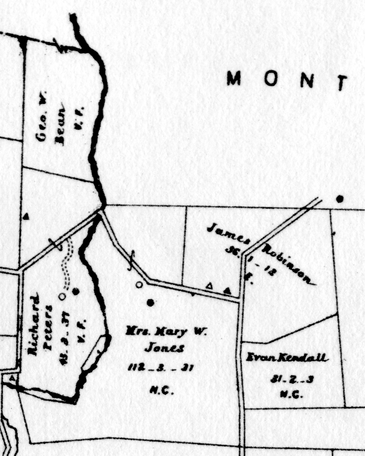
G9-552 1. In Schuylkill. Bounded by lands of Samuel Davis, Peter Suplee, David Conrad, and Abraham Brower. 2. In Schuylkill. Messuage and lot of land bounded by lands of Ezekiel Brower and Nutts Road. 3. In Schuylkill. Messuage and lot of land bounded by lands of Evan Vanderslice, Sarah Purdy died, Charles Adanic and other. 4. In Schuylkill. Lot of land bounded by lands of Nicholas Bean, John Showalter, Robert Jones and others. 5. In Schuylkill. Lot of land bounded by lands of Matthew Ross, Nicholas Bean, and first above described tract. 6. In Schuylkill. Lot of land bounded by lands of E. F. Pennypacker, Nicholas Bean, the Bilton line and others. 7. In Tredyffrin. Lot of land bounded by lands of Ezekiel Bowers, Phoenix Iron Company, and others. 8. In Schuylkill. Lot of land bounded by lands of Ezekiel Bowers, Joseph. Funk, and others. 9. In Tredyffrin. Lot of land bounded by lands of Joseph Funk, and other lands of H. & B.F. Bean, E. F. Pennypacker, the Bilton line. 10. In Charlestown. Messuage and lot of land bounded by lands of John Williamson, Joseph & Benjamin Funk, and John Woseler(?). 11. In Schuylkill. Half interest in lot of land bounded by lands of William Serou(?) Mining Co., Stewart’s land, Thomas Vanderslice, and Caster’s land. | ||||||||||||||||||||||||||||||||||||||||||||||||||||||||||||||||||||||||||||||||||||||||||||||||||||||||||||||||||||||||||||||||||||||||||||||||||||||||||||||||||||||||||||||||||||||||||||||||||||||||||||||||||||||||||||||||||||||||||||||||||||||||||||||||||||||||||||||||||||||||||||||||||||||||||||||||||||||||||||||||||||||||||||||||||||||||||||||||||||||||||||||||||||||||||||||||||||||||||||||||||||||||||||||||||||||||||||||||||||||||||||||||||||||||||||||||||||||||||||||||||||||
Table H.2 McQuiston tract | ||||||||||||||||||||||||||||||||||||||||||||||||||||||||||||||||||||||||||||||||||||||||||||||||||||||||||||||||||||||||||||||||||||||||||||||||||||||||||||||||||||||||||||||||||||||||||||||||||||||||||||||||||||||||||||||||||||||||||||||||||||||||||||||||||||||||||||||||||||||||||||||||||||||||||||||||||||||||||||||||||||||||||||||||||||||||||||||||||||||||||||||||||||||||||||||||||||||||||||||||||||||||||||||||||||||||||||||||||||||||||||||||||||||||||||||||||||||||||||||||||||||
| ||||||||||||||||||||||||||||||||||||||||||||||||||||||||||||||||||||||||||||||||||||||||||||||||||||||||||||||||||||||||||||||||||||||||||||||||||||||||||||||||||||||||||||||||||||||||||||||||||||||||||||||||||||||||||||||||||||||||||||||||||||||||||||||||||||||||||||||||||||||||||||||||||||||||||||||||||||||||||||||||||||||||||||||||||||||||||||||||||||||||||||||||||||||||||||||||||||||||||||||||||||||||||||||||||||||||||||||||||||||||||||||||||||||||||||||||||||||||||||||||||||||
Table H.3 tract | ||||||||||||||||||||||||||||||||||||||||||||||||||||||||||||||||||||||||||||||||||||||||||||||||||||||||||||||||||||||||||||||||||||||||||||||||||||||||||||||||||||||||||||||||||||||||||||||||||||||||||||||||||||||||||||||||||||||||||||||||||||||||||||||||||||||||||||||||||||||||||||||||||||||||||||||||||||||||||||||||||||||||||||||||||||||||||||||||||||||||||||||||||||||||||||||||||||||||||||||||||||||||||||||||||||||||||||||||||||||||||||||||||||||||||||||||||||||||||||||||||||||
| ||||||||||||||||||||||||||||||||||||||||||||||||||||||||||||||||||||||||||||||||||||||||||||||||||||||||||||||||||||||||||||||||||||||||||||||||||||||||||||||||||||||||||||||||||||||||||||||||||||||||||||||||||||||||||||||||||||||||||||||||||||||||||||||||||||||||||||||||||||||||||||||||||||||||||||||||||||||||||||||||||||||||||||||||||||||||||||||||||||||||||||||||||||||||||||||||||||||||||||||||||||||||||||||||||||||||||||||||||||||||||||||||||||||||||||||||||||||||||||||||||||||
Table H.4 tract - Vodges tracts #4, 10, 11 | ||||||||||||||||||||||||||||||||||||||||||||||||||||||||||||||||||||||||||||||||||||||||||||||||||||||||||||||||||||||||||||||||||||||||||||||||||||||||||||||||||||||||||||||||||||||||||||||||||||||||||||||||||||||||||||||||||||||||||||||||||||||||||||||||||||||||||||||||||||||||||||||||||||||||||||||||||||||||||||||||||||||||||||||||||||||||||||||||||||||||||||||||||||||||||||||||||||||||||||||||||||||||||||||||||||||||||||||||||||||||||||||||||||||||||||||||||||||||||||||||||||||
| ||||||||||||||||||||||||||||||||||||||||||||||||||||||||||||||||||||||||||||||||||||||||||||||||||||||||||||||||||||||||||||||||||||||||||||||||||||||||||||||||||||||||||||||||||||||||||||||||||||||||||||||||||||||||||||||||||||||||||||||||||||||||||||||||||||||||||||||||||||||||||||||||||||||||||||||||||||||||||||||||||||||||||||||||||||||||||||||||||||||||||||||||||||||||||||||||||||||||||||||||||||||||||||||||||||||||||||||||||||||||||||||||||||||||||||||||||||||||||||||||||||||
Table H.5 tract | ||||||||||||||||||||||||||||||||||||||||||||||||||||||||||||||||||||||||||||||||||||||||||||||||||||||||||||||||||||||||||||||||||||||||||||||||||||||||||||||||||||||||||||||||||||||||||||||||||||||||||||||||||||||||||||||||||||||||||||||||||||||||||||||||||||||||||||||||||||||||||||||||||||||||||||||||||||||||||||||||||||||||||||||||||||||||||||||||||||||||||||||||||||||||||||||||||||||||||||||||||||||||||||||||||||||||||||||||||||||||||||||||||||||||||||||||||||||||||||||||||||||
| ||||||||||||||||||||||||||||||||||||||||||||||||||||||||||||||||||||||||||||||||||||||||||||||||||||||||||||||||||||||||||||||||||||||||||||||||||||||||||||||||||||||||||||||||||||||||||||||||||||||||||||||||||||||||||||||||||||||||||||||||||||||||||||||||||||||||||||||||||||||||||||||||||||||||||||||||||||||||||||||||||||||||||||||||||||||||||||||||||||||||||||||||||||||||||||||||||||||||||||||||||||||||||||||||||||||||||||||||||||||||||||||||||||||||||||||||||||||||||||||||||||||
Table H.6 tract | ||||||||||||||||||||||||||||||||||||||||||||||||||||||||||||||||||||||||||||||||||||||||||||||||||||||||||||||||||||||||||||||||||||||||||||||||||||||||||||||||||||||||||||||||||||||||||||||||||||||||||||||||||||||||||||||||||||||||||||||||||||||||||||||||||||||||||||||||||||||||||||||||||||||||||||||||||||||||||||||||||||||||||||||||||||||||||||||||||||||||||||||||||||||||||||||||||||||||||||||||||||||||||||||||||||||||||||||||||||||||||||||||||||||||||||||||||||||||||||||||||||||
| ||||||||||||||||||||||||||||||||||||||||||||||||||||||||||||||||||||||||||||||||||||||||||||||||||||||||||||||||||||||||||||||||||||||||||||||||||||||||||||||||||||||||||||||||||||||||||||||||||||||||||||||||||||||||||||||||||||||||||||||||||||||||||||||||||||||||||||||||||||||||||||||||||||||||||||||||||||||||||||||||||||||||||||||||||||||||||||||||||||||||||||||||||||||||||||||||||||||||||||||||||||||||||||||||||||||||||||||||||||||||||||||||||||||||||||||||||||||||||||||||||||||
Table H.8 tract - Vodges tract #8 | ||||||||||||||||||||||||||||||||||||||||||||||||||||||||||||||||||||||||||||||||||||||||||||||||||||||||||||||||||||||||||||||||||||||||||||||||||||||||||||||||||||||||||||||||||||||||||||||||||||||||||||||||||||||||||||||||||||||||||||||||||||||||||||||||||||||||||||||||||||||||||||||||||||||||||||||||||||||||||||||||||||||||||||||||||||||||||||||||||||||||||||||||||||||||||||||||||||||||||||||||||||||||||||||||||||||||||||||||||||||||||||||||||||||||||||||||||||||||||||||||||||||
| ||||||||||||||||||||||||||||||||||||||||||||||||||||||||||||||||||||||||||||||||||||||||||||||||||||||||||||||||||||||||||||||||||||||||||||||||||||||||||||||||||||||||||||||||||||||||||||||||||||||||||||||||||||||||||||||||||||||||||||||||||||||||||||||||||||||||||||||||||||||||||||||||||||||||||||||||||||||||||||||||||||||||||||||||||||||||||||||||||||||||||||||||||||||||||||||||||||||||||||||||||||||||||||||||||||||||||||||||||||||||||||||||||||||||||||||||||||||||||||||||||||||