|
Note: in these deed histories distances are quoted in perches (p) of length 16.5 feet. Areas are quoted in acres (a) and square perches (p). There are 160 square perches to an acre. In a few cases roods (a quarter of an acre) are also used.
|
|
|
From |
To |
Date |
Area |
Cost |
Reference |
|
|
|
|
|
|
Penn |
David Meredith |
4/16/1706 |
1340a & 160a |
|
Warrant D73-84; Survey D73-92; Patent A3-270 |
David Meredith |
David Powell |
11/15/1706 |
1340a & 160a |
£150 |
B-81 |
David Powell |
Lewis Walker |
4/28/1708 |
400a & 160a |
|
See table G.1 |
David Powell |
John Havard |
4/14/1707 |
800a |
|
See table G.2 |
David Powell |
Henry John |
|
140 or 100a |
|
Deed not found; Northeast corner of 1340a; see table H |
|
|
Survey D73-92 This survey has dubious dates and is probably has an incorrect northern boundary. This boundary is annotated – rejusted Welsh line dividing it from the Manor of Bilton.
Patent A3-270 Beginning at a corner post, thence by line of Griffith John WSW 206p to a post, thence SE (should be SSE for closure) by James Atkinson 124p to a post, thence ENE 206p by Thomas Simons, thence by Henry Lewis NNW 124p. 160a SW corner Baptist Church (this is the 160a plot).
B-81 Deed. On 15 Nov 1706 David Meredith of Chester County, yeoman, to David Powell, City of Philadelphia, yeoman. Whereas William Penn by deed dated 16 Apr last past, did grant & convey to David Meredith a tract in the Welsh Tract bounded by land of Captain John Mordent, John Kinsey & Owen Gethin & Jonathon Wynn, containing 1340 acres, also another tract bounded by land of Griffith John, James Atkinson, Thomas Lymon & Henry Lewis, containing 160 acres. Now David Meredith for £150 grants to David Powell 2 tracts one containing 1340 acres, the other containing 160 acres. Signed David Meredith. Delivered in the presence of Stephen Evans, David Thomas, John Havard & William Havard. Recorded 14 Apr 1707.
|
|
Table G.1 – Lewis Walker tract – Davis / Blue Stone Farm
|
From |
To |
Date |
Area |
Cost |
Reference |
|
|
|
|
|
|
|
|
4/28/1708 |
400a & 160a - for 160a tract see table AU |
£161 |
B-214 |
Lewis Walker |
Llewellyn David |
10/16/1708 |
300a Part of aforesaid tracts) |
£90 |
B-291 |
Lewellin David |
|
1715 |
|
|
tax |
Llywelyn David |
|
1718 |
|
|
tax |
Luellin David |
|
1719 |
|
|
tax |
Late of Llewellin David |
|
1724 |
|
|
Road plan; occupied by James David |
Lewellyn Davis |
Isaac, Elizabeth, Sarah, & Llewelyn Davis |
1734? Died before 1725 |
|
|
Inheritance by 4 children |
Elizabeth, Sarah, & Llewelyn Davis |
Isaac Davis |
4/25/1742 |
300a |
10s |
B2-387; release |
Isaac Davies |
|
1739 |
|
|
Tax |
Isaac Davis |
|
1760 |
300a |
|
Tax; mill |
Isaac Davis |
|
1765 |
265a + 35a hill |
|
Tax; sawmill |
Isaac Davis |
|
1767 |
230a |
|
tax |
Isaac Davis |
Benjamin Davis (son) |
1/19/1774 |
135a |
5s yearly rent |
W-235; see table G.1.2 |
John Wilson |
Isaac Davis |
7/27/1774 |
10a 20p |
|
F2-506; Woodland |
Isaac Davis |
|
1778 |
|
|
Administration |
Admin of Isaac Davis (Elizabeth, widow & John, son) |
Thomas Davis |
3/14/1779 |
76a & 10a 20p |
|
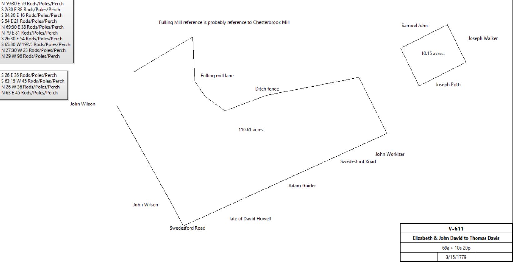
V-611 |
|
Benjamin Davis |
|
1779 |
26a |
|
tax |
Thomas Davis |
|
1779 |
86a |
|
tax |
Benjamin & Thomas Davis |
Elizabeth Davis et al |
3/31/1779 |
|
|
V-609 release |
Elizabeth Davis |
John Davis, son |
3/31/1779 |
|
5s |
V-614. release of estate |
Thomas Davis |
|
1785 - 88 |
75a |
|
tax |
John Davis |
|
1787 |
170a |
|
County tax; |
John Davis |
|
1789 |
170a |
|
County tax; |
Thomas & Sarah Davis of Coventry |
John Davis |
1/3/1791 |
75a |
£750 |
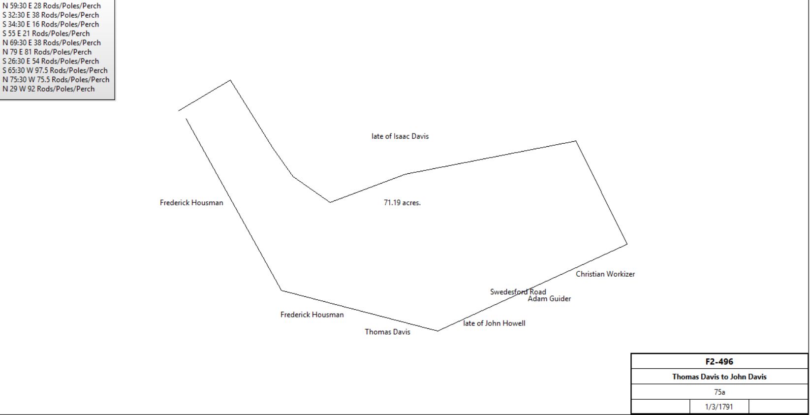
F2-496 |
|
John Davis |
|
1791 |
180a |
|
County tax; |
Thomas & Sarah Davis of Coventry |
David Wilson |
4/8/1792 |
2a 24p |
£16 |
H2-375; see G.1.4 for further history |
John Davis |
|
1795 |
226a + 35a hill |
|
County tax; ½ sawmill (with Jacob Baugh) |
John Davis |
|
1797 |
226a + 35a hill |
|
County tax; ½ sawmill |
John Davis |
|
1798 |
261a |
|
County tax; ½ sawmill (with Jacob Baugh) |
John Davis |
|
1798 |
118a + 42a hill |
|
Glass tax; neighbor David Havard. ½ sawmill (with Baughs) |
John Davis |
|
1799 |
226a + 42a hill |
|
tax |
John & Joanna Davis |
John Morton Davis (son) |
4/29/1813 |
61a 140p + 10a |
$7,000 |
H3-372 |
John M. & Ann Davis; Ann Davis, Benjamin Davis |
Charles J. Davis & Mary Davis |
4/28/1828 |
185a + 32a |
$6,652 |
M4-70; release; heirs of John Davis esquire. |
Charles J. Davis advertisement |
|
9/14/1836 |
165a |
|
See below |
Charles & Mary Davis |
William Walley |
2/18/1837 |
165¼a |
$16,541 52c |
P4-389 |
William Walley |
Ann Davis, nee Anna Maria Walley, daughter |
7/8/1837 (will) |
|
|
died |
Ann Davis |
|
1848 |
|
|
died |
|
|
Henry Walley (trustee) for the children of Ann Davis |
William W Davis |
4/1/1850 |
165¼a |
$13,401 77.5c |
L5-141 |
William W. Davis |
|
1883 |
180a 1r |
|
Breou's atlas |
Albert K. Davis (68a) and Edward Cassatt |
|
1912 |
|
|
Atlas |
|
|
|
|
|
|
John M. Davis |
Horatio Suplee |
3/20/1840 |
1a 22p |
$100 |
T4-23 |
John M. & Anna Davis |
Samuel Karnaghan |
2/13/1843 |
9.5a 27p |
$628 46c |
Y4-378; see Table C for continuation |
John M. Davis |
|
1847 |
|
|
Died intestate |
Albert K. Davis |
|
1883 |
70a |
|
Breou map |
Albert K. & Matilda Davis |
A. J. Cassatt |
8/20/1887 |
3.306a |
$1 |
G10-171 |
Albert K. Davis estate |
|
1912 |
68a |
|
1912 map |
John M. Davis |
|
|
|
|
son |
|
|
|
|
|
|
John M. Davis |
Emily Given, widow |
10/25/1917 |
53.958a |
$9,500 |
E15-164 |
Emily Given |
W. Ellis Johnson |
5/19/1933 |
53.958a |
$1 |
Y18-206 |
|
|
|
|
|
|
John M. Davis, inherited from Albert Davis |
Emily Given |
11/3/1921 |
0.928a |
$195 |
Y15-514 |
Emily Given |
Samuel Given |
2/14/1924 |
0.928a |
$1 |
M16-34 |
Samuel & Catharine Given |
W. Ellis Johnson |
5/9/1933 |
11.122a + 84p +0.928a |
$10,000 |
Y18-207 |
W. Ellis Johnson |
Warren A. Croll |
|
|
|
M24-201; deed not found |
|
|
|
16,816ft2 |
|
|
W. Ellis and Emma Johnson |
W. E. Johnson Inc |
12/1/1953 |
28.443a |
|
G26-43 |
W. Ellis and Emma Johnson |
W. E. Johnson INC |
|
4.988a |
|
G28-139 |
|
|
|
|
|
|
John Morton Davis |
W. Ellis Johnson |
8/15/1925 |
1a |
$500 |
A17-157 |
|
|
|
|
|
|
Sheriff (Suit of Home Owners’ Loan Association against Beradino & Filamena DiBiaso) |
Home Owners’ Loan Association |
10/28/1937 |
3a |
|
O19-309; Sheriff's Deed |
Home Owners’ Loan Association |
Frank & Sarah Bolden (¾ part) and Charles and Estella Crawford (¼ part) |
2/27/1939 |
3a |
$2,500 |
D20-426 |
|
|
|
|
|
|
Charles & Estella Crawford |
Frank & Sarah Bolden |
5/4/1948 |
¼ part of 3a |
$1 |
X23-160 |
Frank & Sarah Bolden |
W. Ellis and Emma Johnson |
7/25/1952 |
2.5a |
$3,500 |
R25-134 |
W. E. Johnson Inc. |
Warner Company |
2/15/1957 |
28.443a |
$56,937 53c |
B29-526 |
W. Ellis and Emma Johnson |
Warner Company |
3/12/1965 |
1.764a |
$40,000 |
G36-339 |
Emma Johnson, co-executor of the will of W. Ellis Johnson, National Bank of Chester County Trust Company |
Warner Company |
12/29/1965 |
53.958a - tracts above |
$165,000 |
U36-297 |
|
|
|
|
|
|
Warner Company |
30 Fathoms inc |
6/1/1978 |
|
|
B53-399 not found |
30 Fathoms inc |
Warner Company |
6/30/1980 |
10.808 |
$34,500 |
Y56-380 |
|
|
|
|
|
|
Warner Company |
Quarry Associates |
5/22/1984 |
37.518a + 16.021a |
$1.95M |
M63-208 |
Quarry Associates |
Quarry Office Park Associates |
6/17/1985 |
56.215a |
$7.5M |
V65-83 |
Mack-Cali Pennsylvania Realty Associates |
Westlakes Land KPG |
8/26/2013 |
not given |
$420,000 |
8801-698 |
|
|
|
|
|
|
Lawrence & Mabel Pyle |
Pedro and Margaret Louise Navarro |
4/6/1963 |
2.73933a |
$1 |
G35-907; previous deed not found |
Oscar and Hanna Souders |
Pedro and Margaret Louise Navarro |
4/2/1963 |
2.73933a |
$1 |
G35-904; this deed is for a 60' x 90' plot of land devised in the will of Margaret Souders, who died 10/1/1940 |
Pedro and Margaret Louise Navarro |
Margaret Louise and Pedro Navarro |
5/23/1963 |
2.73933a |
$1 |
G35-913 |
Matilda Butcher, exectrix of the will of Pedro Navarro |
Matilda Butcher |
5/17/1996 |
|
$1 |
4034-0569 |
Matilda Navarro Butcher |
|
2002 |
|
|
Davis descendant. See Howellville by Sue Andrews |
Justine Navarro, exectrix of the will of Matilda Butcher |
Justine Navarro |
2/17/2011 |
2.73933a |
$1 |
8125-529 |
|
|
B-214 Deed. On 24 Apr 1708 David Powell of Philadelphia, yeoman, to Lewis Walker of Radnor, yeoman. Whereas William Penn by patent dated 16 Apr 1706 granted to David Meredith land in the Welch tract, containing 1340 acres & another tract bounded by land of Griffith Johns, James Atkinson, Thomas Simon & Henry Lewis, containing 160 acres. David Meredith by deed dated 15 Nov 1707, recorded Chester, Book B, page 81, granted to David Powell both tracts. Now David Powell for £161 grants to Lewis Walker a tract containing 160 acres & a tract bounded by land of John Mordent & John Havard containing 400 acres, being part of 1340 acres. Signed David Powell. Delivered in the presence of Stephen Evans & Richard Orme. Recorded 29 May 1708.
B-291 Deed. On 16 Oct 1708 Lewis Walker of Valley in Chester County, yeoman, to Lewellyn David of Haverford, sawyer. Whereas David Powell of the City of Philadelphia, surveyor by deed dated 24 Apr 1708 granted to Lewis Walker a tract in the Welch Tract in Chester County containing 160 acres; also another tract containing 400 acres, recorded at Ridley in Chester, Book B, page 214, on 29 May 1708; both tracts being part of tract David Powell purchased of David Meredith, the land granted to David Meredith by the present commissioners, recorded 16 Apr 1706, recorded in Philadelphia, Book A, Vol 3, page 81. Now Lewis Walker for £90 grants to Lewellyn David a tract being part of the first mentioned 2 tracts in the Welch Tract bounded by land of John David, John Moident & John Havard containing 300 acres. Signed Lewis Walker. Delivered in the presence of Jonas Sandelands, John Evans & Jonathon Simcock Jr. recorded 2 Nov 1708.
B2-387 Bounded ENE by John Havard’s land, SSE by John David Griffith, WSW by Thomas James, and NNW by the Welsh tract.
V-609 Release to Elizabeth Davis, widow of Isaac Davis & children by Benjamin Davis (who received 135 acres from father) & Thomas Davis (who received 86 a 20p) from administration. £500 each to John and Mary (eldest daughter) Morgan, Sarah & Elizabeth Davis (what about Dr Joseph Davis? Dead?)
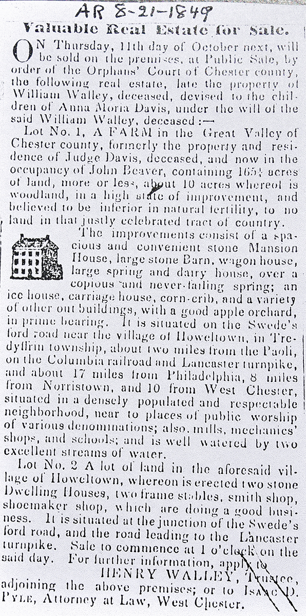
from the Village Record
September 14, 1836
PUBLIC SALE
Will be exposed to public sale on Thursday, the 13th of October next, at 12 o'clock, on the premises, a first rate Valley and dairy FARM, situate in the township of Tredyffrin, county of Chester, 18 miles from Philadelphia, 12 from West Chester, 8 from Norristown, 1 1-2 from Columbia rail road. The improvements are a large mansion HOUSE, with six rooms on a floor, two large stone barns, with a sufficient quantity of stabling, a well of good water in the barn yard, with a pump therein, sheep stable, a large frame grain house, with two good corn cribs adjoining, wagon house, with granaries over, hog house, carriage house, smoke house, an excellent milk house over a never failing spring of water, sufficiently large to contain the milk of 30 cows, with a lodging room over. This farm contains 165 ACRES; - the soil is limestone of the best quality, and at present in the highest state of improvement, every field having of late years been heavily manured by means of a large grain fed stock, and abundantly limed. It includes also a large proportion of very productive watered meadow, and a good proportion of thriving timber; the fencing is of chestnut rails, and in good order. On the premises is a young orchard, and a quantity of good cherry trees; the farm has the little Valley creek passing through its centre, with a mill seat thereon, besides being well supplied with other streams, having water in nearly every field. The above property is bounded by lands of John Kugler, Wm. Brown, John M. Davis, David Havard and others, with the Norristown and Valley rail road passing through the south east corner of it; convenient to places of worship of several denominations, schools, mills, Sc. Should any purchaser find the whole too large to cultivate, it can be divided into two parts, one of which, with buildings will constitute a beautiful farm of about 100 acres of the choicest land, the other having an excellent opening with a very eligible situation for building near the same. Terms at sale. The title is clear and indisputable.
For further particulars apply to the subscriber, residing on the premises.
Charles J. Davis
|
Table G.1.1 – Llewelyn David – Chesterbrook Mill
|
From |
To |
Date |
Area |
Cost |
Reference |
|
|
|
|
|
|
Llewelyn David |
John David alias John Howell |
7/4/1710 |
|
|
Will |
John David Howell |
|
1715 |
|
|
Tax of 6d may be Brone Hall |
John Howell |
|
1718 |
|
|
County tax. |
John Howell |
|
1719 |
|
|
County tax. |
John Howell |
|
1720 |
|
|
County tax. |
John Howell |
|
1721 |
|
|
County tax. |
John Howel |
|
1722 |
|
|
County tax. |
John Howell |
|
1724 |
|
|
County tax. |
John Howell |
|
1725 |
|
|
County tax. |
John Howell |
|
1726 |
|
|
County tax. |
John Howell |
Elizabeth Howell, wife |
5/25/1729 |
|
|
Will. Property Bron Hall while a widow |
John Thomas & Elinor |
Elizabeth Howell |
5/26/1731 |
|
|
Quoted in K-5 |
Elizabeth Howell |
John Thomas or Thomas John |
6/1/1731 |
105a |
|
K-5a Brone Hall. Deed of Trust |
Elizabeth Howell |
George Hughes |
|
|
|
Marriage |
George Hughes |
|
1732, 1734, 1735 |
|
|
tax |
George Hughes |
|
4/12/1735 |
50a |
|
Warrant H-29 |
|
|
2/17/1736 |
50a |
|
Survey C76-122 |
Penn |
George Hughes |
4/9/1736 |
50a |
|
Patent A-7-536; north of Llewelyn David tract |
Elizabeth Hughes |
|
1737 |
|
|
tax |
George Hugh |
|
1760 |
50a |
|
7 residents; Tax 5s 3d |
Joseph & Mary Hughes
(son & heir) |
Joseph Mitchell |
5/6 & 7/1765 |
105a & 50a |
|
Deed not found |
Joseph & Ann Mitchell |
Joseph Richardson |
3/6/1769 |
105a & 50a + tract in Blockley |
2,233 Spanish Dollars |
Q-122 Mortgage. Brown’s Hall. Same description as E2-236 |
Joseph & Ann Mitchell |
Jonathan Humphreys |
1770 |
105a & 50a |
|
R-108 Mortgage |
Joseph Mitchell |
|
3/29/1770 |
|
|
Pennsylvania Gazette |
Joseph Mitchell |
|
1778 |
155a |
|
Tax reduced as had been plundered. Mill. |
Joseph Mitchell |
|
1779 |
155a |
|
Tax. 3 horses, 5 cattle, 1 mill, Plate: 6 tea spoons |
Sheriff |
Henry Zook |
3/16/1789 |
105a & 50a |
|
Grist mill & 2 tracts; Sheriff’s deed #1-55. Previous owners: Joseph & Ann Mitchell. Previously Joseph Hughes of Wales? Brown’s Hall |
Sheriff (Charles Dilworth) |
Henry Zook |
3/16/1790 |
105a & 50a |
£837 10s |
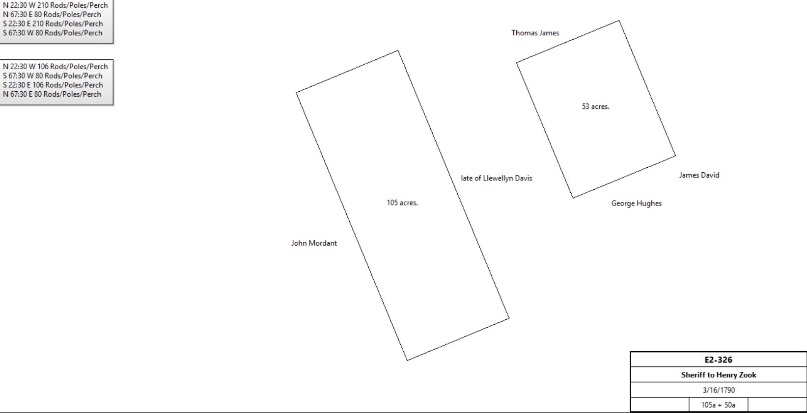
E2-326. Corn or Grist Mill. Suit of Nicholas & Sarah Waln administrators of the will of Joseph Richardson. Brown’s Hall |
|
Henry & Barbara Zook |
Nicholas Waln |
1790 |
123+a |
|
Mortgage C-323 Paid off 1796 |
Henry Zook |
|
1796 |
155a (+ 100a hill land) |
|
Tax: Grist mill, 6 horses, 4 cattle |
|
|
|
|
|
See Table D for John Garber sale |
Henry & Barbara Zook |
Adam Siter |
1/30/1797 |
75a 30p (part of 105a) + 50a (part of Isaac Potts’ patent, Springfield, of 96¾a; and Henry Zook’s patent, Chestnut Ridge, of 39a) |
£3500 |
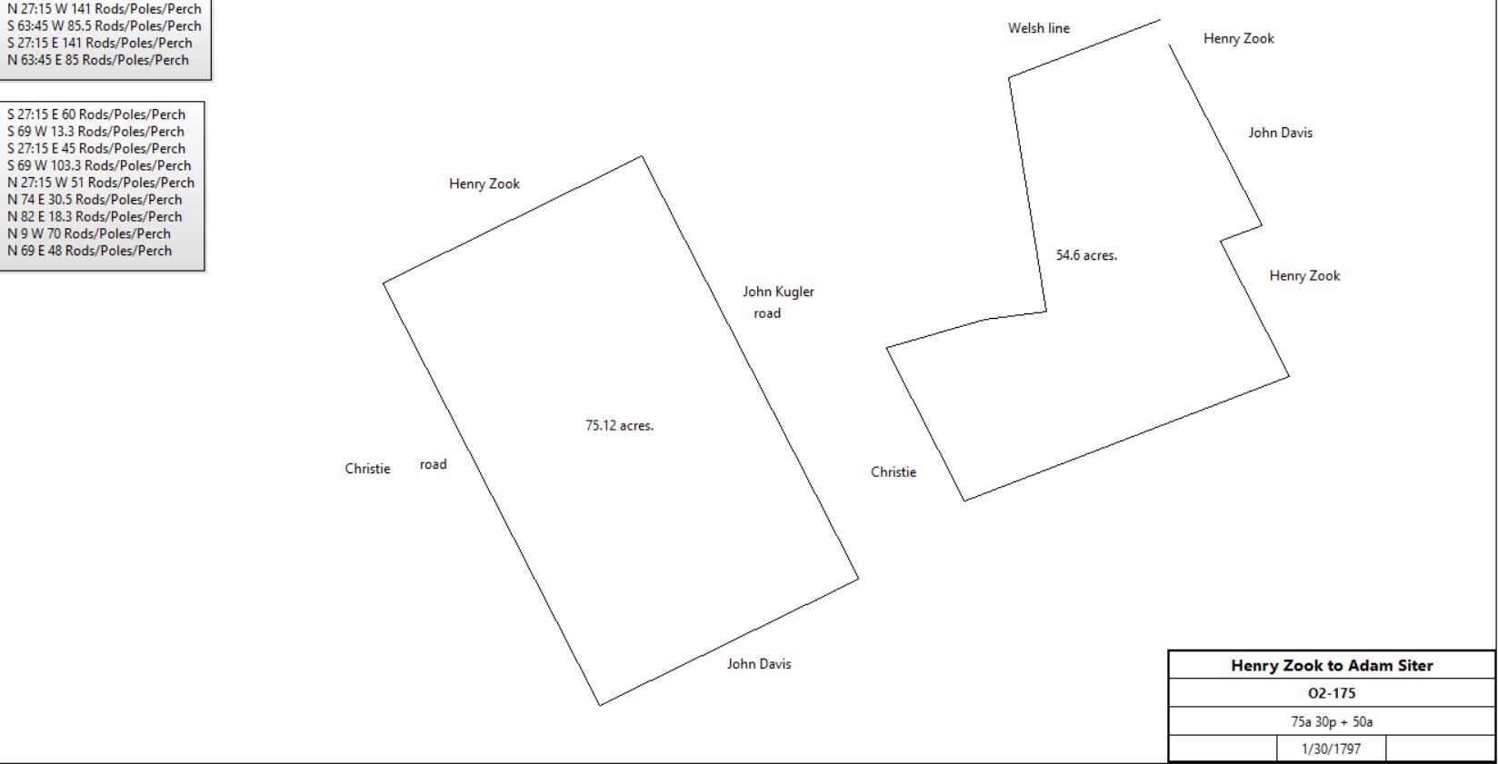
O2-175. See Survey. Zook described as miller & farmer. |
|
Henry & Barbara Zook |
William Scholfield |
3/24/1797 |
6a 40p |
£112 10s |
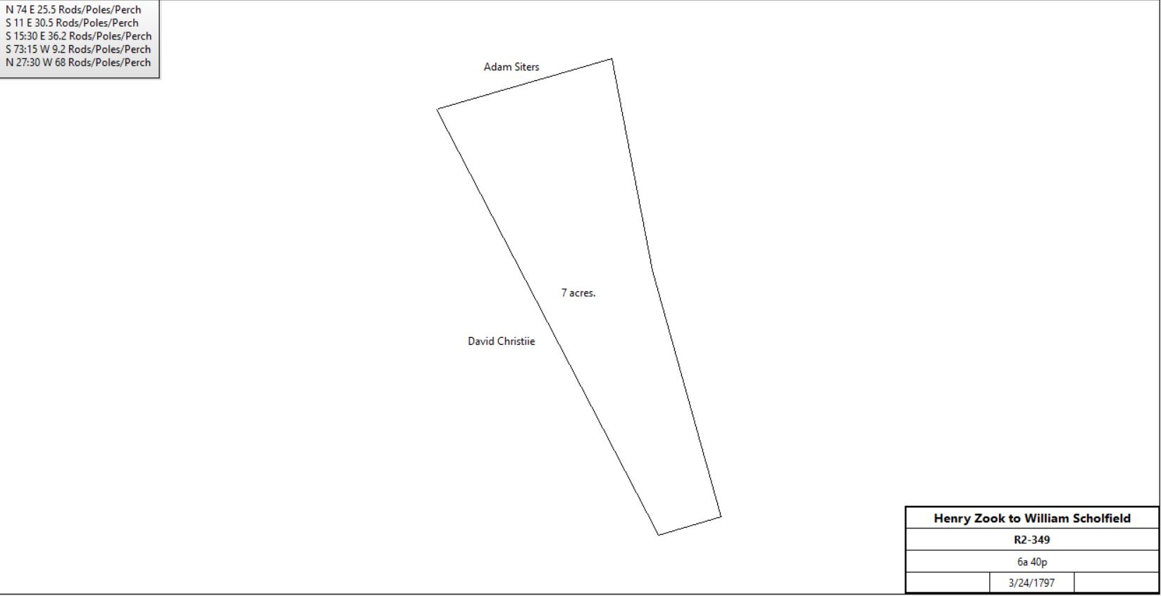
R2-349; part of 155a |
|
Estate of Adam Siter |
|
1798 |
74a & 49a |
|
Glass tax; Grist Mill |
Execs. of Adam Siter |
Samuel King |
3/23/1801 |
75a 30p
50a |
£2910 |
T2-633 |
Samuel & Catherine King |
Levi Evans |
4/1/1803 |
75a 30p
50a |
£3050 |
W2-543 King described as miller. |
Levi & Susannah Evans |
Devault Beaver |
4/17/1805 |
75a 30p +
50a |
$3100 |
Z2-39. Evans described as miller. |
|
|
1810 |
31a 3r |
|
Survey by Samuel Beaver (part of 50a) |
David Beaver |
|
1823 |
|
|
Road deed |
Devault & Margaret Beaver |
John Beaver |
6/21/1826 |
60a 62p |
$3,359 |
Z3-199; see Table G.1.1.a below for continuation |
Devault & Margaret Beaver |
David Beaver |
3/29/1827 |
23a + 12½a + 5¾a |
$3605 |
B4-70 First plot description mentions mill race; see table G.1.1.b for last tract |
David Beaver |
Wife, Daniel H. Beaver, Samuel Beaver jr., David Beaver |
1827 |
|
|
Died intestate |
David Beaver jr. |
|
before 1835. |
|
|
Died intestate |
Daniel Beaver & Hannah, his wife |
Samuel Beaver jr. |
10/29/1835 |
a) 23a b) 12½a c) 5¾a |
$2130 |
K4-378 Release. Next to Thomas John's land |
David Beaver jr. |
|
before 1835. |
|
|
Died intestate |
Daniel H. Beaver
& Hannah, wife |
Samuel Beaver |
4/17/1843 |
3 parcels |
$2,000 |
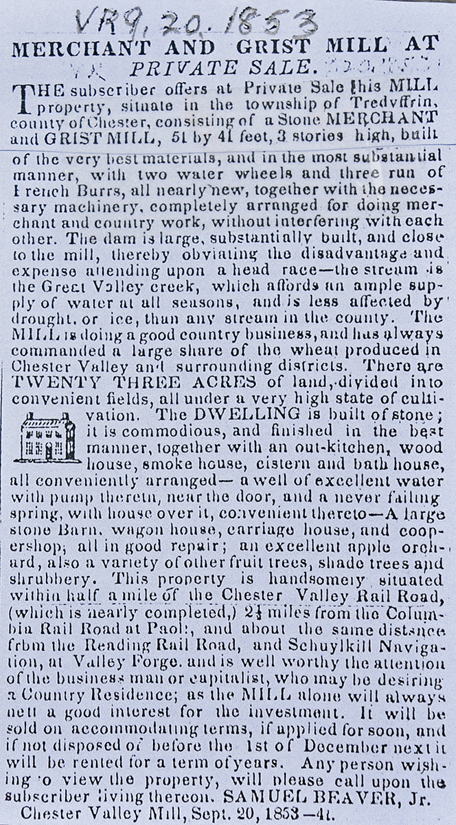
X4-408 release; messuage, grist and saw mill; seems to be same parcels as K4-378, but mentions the buildings. |
|
Samuel & Elizabeth Beaver |
Lewis Worrall |
3/27/1855 |
23a |
$12,100 |
X5-426 |
Samuel Beaver & Elizabeth, his wife |
Nicholas Bean |
9/1/1856 |
12a Tred. |
$437 50c |
B6-87 |
Joseph M. Fronefield |
|
1873 |
|
|
Mill operator. |
J.Harrison Rennard |
|
1883 |
23a |
|
Breou |
J.Harrison Rennard |
|
2/3/1891 |
|
|
Mill rented to Hoopes M. Vandever of Downingtown |
Sheriff (estate of J.H. Rennard) |
Henry Hause |
2/2/1899 |
|
|
Deed docket 14, p. 58 |
Henry & Ellie Hause |
Samuel Fetters |
12/21/1900 |
23a+ |
$2875 |
E12-22 Messuage, mill, plantation & tract of land |
Trustee |
Mary L. Dewees |
4/10/1916 |
23a |
|
W14-246 |
Mill burned |
|
Spring 1920 |
|
|
|
Seely & Mary L. Dewees |
Richard Haughton |
6/10/1920 |
23a |
|
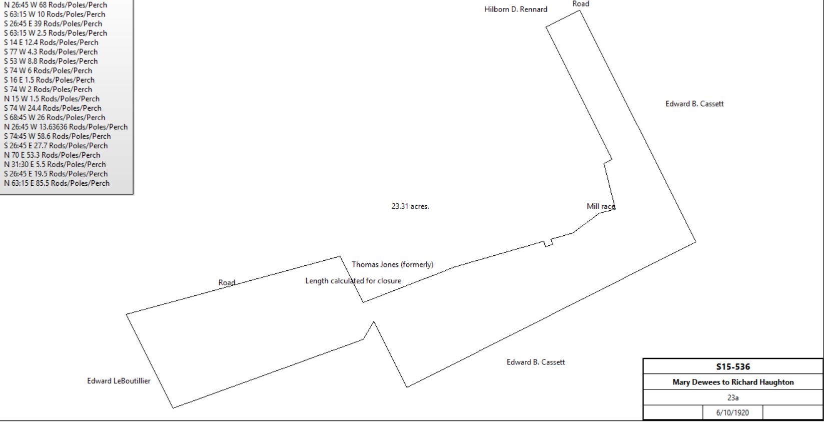
S15-536 |
|
Richard & Marie Haughton |
George R. Packard & Haughton |
11/18/1921 |
|
$1 |
A16-50 (same property as S15-536) |
George R. Packard & Haughton |
Arthur T. & Isabel S.Lowry |
4/15/1925 |
5.611a |
$1 |
N16-61; part of A16-50 |
Arthur T. & Isabel S.Lowry |
Daniel & Ethel C. Badger |
1/3/1927 |
5.611a |
$1 |
D17-592 |
Daniel Badger |
|
8/11/1944 |
|
|
Died |
Ethel C. Badger |
Eric C. B. & Katharine L. Gould |
10/6/1947 |
5.611a |
$50,000 |
A23-255 |
Eric C. B. Gould |
James H. Luther |
8/12/1959 |
|
|
I31-519 |
James H. Luther |
Dean E. Burget jr. |
8/11/1971 |
|
|
C40-464 |
Dean E. Burget jr. |
William F. Drake jr. |
12/5/1975 |
|
|
B47-55 |
|
|
Q-122: Messuage, water corn & grist mill and tract by name of Brown’s Hall in Tredyffrin beginning at a post in the line of John Mordant thence NNW 210 perches to a post, ENE by the line of marked tree 80 perches, SSE by marked trees dividing this from Llewelling David 210 perches thence WSW 80 perches to the place of beginning.
The Pennsylvania Gazette
March 29, 1770
To be SOLD, by the Subscriber, A PLANTATION in the Great Valley, 21 miles from Philadelphia, it lies in the township of Tredyffrin, in the county of Chester, and may be entered on the middle of April 1770; the purchaser may have some 100 or 300 acres; the land is very good, and may be always kept so, with little trouble, for there is plenty of limestone and timber on said land; any person inclining to purchase, may know the terms,
by applying to Joseph Mitchell, at his mill in said township.
K-5 Deed of Trust. On 1 June 1731 Elizabeth Howell, now or late of Tredyffrin, widow to Thomas John of Glandy in the township of Charlestown, yeoman. Witness that Llewelyn David, late of Tredyffrin yeoman, dec. by deed dated 4 July 1710 granted to John David, alias ' John Howell late of Tredyffrin, yeoman, dec. a tract of land in Tredyffrin bounded by land of John Mordant & Llewelyn David containing 105 acres. John Howell made his will dated 25 May 1729 & devised all his estate to his wife Elizabeth Howell as during the term she remained his widow & further did give & bequeath to John Thomas of Tredyffrin, weaver, all of the estate lands & tenements called Brone Haul, & soon after died. Whereas John Thomas & Elinor his wife by deed dated 26 May 1731 granted all their estate right in said land to Elizabeth Howell. Now Elizabeth Howell granted to Thomas John all 105 acres in special trust; there is a marriage to be solemnized between Elizabeth Howell & George Hughes of Charlestown, yeoman, the said Thomas John shall stand seized of the said land & promises to the use of George Hughes & Elizabeth during their natural lives & life of the survivor of them, & after the dec. of George Hughes & Elizabeth, Thomas John shall stand seized of land to use of the heirs of George Hughes begotten of the body of Elizabeth.
Beginning in the line of John Mordant, thence NNW by said line 210 perches to corner post, thence ENE by line of marked trees 80 perches to a corner post, thence by a line of marked trees dividing it from the said David Llewelyn’s land 210 perches to a marked tree, thence WSW 80 perches to the place of beginning.
Signed Elizabeth Howell. Delivered in the presence of Griffith Evans & Richard Jones. Recorded 18 June 1755.
|
Table G.1.1.a – John Beaver tract
|
From |
To |
Date |
Area |
Cost |
Reference |
|
|
|
|
|
|
Devault & Margaret Beaver |
John Beaver |
6/21/1826 |
60a 62p |
$3,359 |
Z3-199; from above. Inlcuding woodland of 31a 120p |
Davcd Meconkey, surviving executor of John Beaver |
David R. Clemens |
4/4/1867 |
6a 1p + 7a 20p |
$1,328 20c |
E7-577, part of woodland of 31a 120p |
David R. Clemens |
Nicholas Bean |
11/15/1867 |
3a 101p (part of E7-577) |
$90 78c |
L8-62 |
Mary Ann & Henry Bean, Matthias Pennypacker, executors of the will of Nicholas Bean |
Alfred U. Bean |
12/23/1878 |
5a 115p (part of B6-87 and L8-62) |
$216 97c |
F9-225 |
|
Table G.1.1.b – Woodlot
|
From |
To |
Date |
Area |
Cost |
Reference |
|
|
|
|
|
|
Samuel & Elizabeth Beaver |
William Ritter |
3/27/1855 |
5¾a |
$242 |
Z5-537 |
Henry Ritter and Edward Wilson, executors of the will of William Ritter |
John Groff |
5/6/1857 |
5¾a |
$356 50c |
M8-484 |
|
Table G.1.2 – Benjamin Davis / John Koogler tract
|
From |
To |
Date |
Area |
Cost |
Reference |
|
|
|
|
|
|
Isaac Davis |
Benjamin Davis (son) |
1/19/1774 |
135a |
5s yearly rent |
W-235 |
Isaac Davis |
Benjamin Davis |
1/19/1774 |
135a |
£100 |
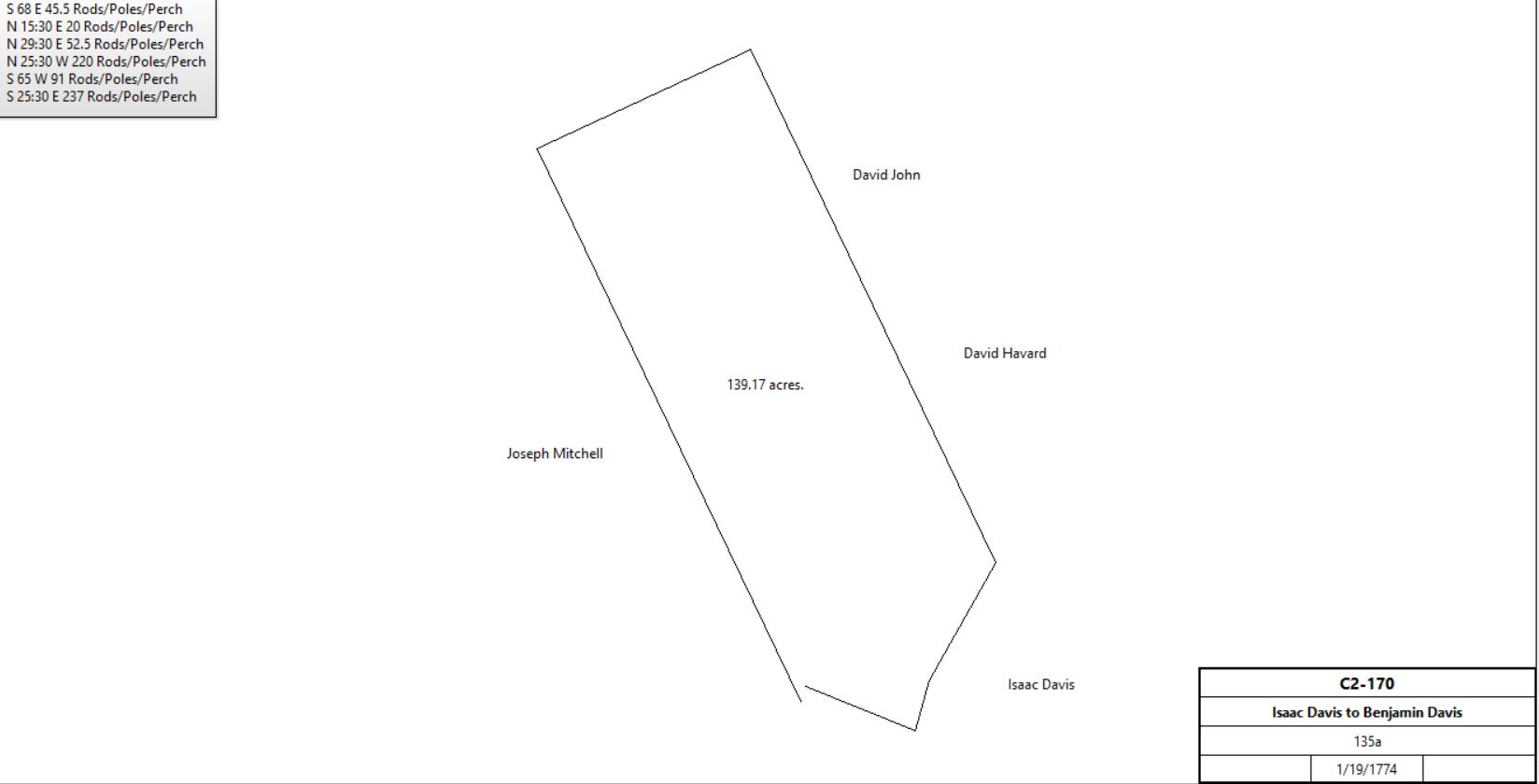
C2-170 |
|
Benjamin Davis |
|
1778 |
130a |
|
tax |
Benjamin & Mary Davis |
John Koofield |
4/7/1787 |
135a |
£1500 |
C2-172 same citation as C2-170 |
Benjamin Davis |
John Koogler |
1787 |
135a |
|
Mortgage C-173 paid off 1799 |
Isaac Potts |
John Koogler |
11/16/1791 |
32¼a |
|
G2-166 |
John Koogler |
|
1796 |
135a |
|
Tax |
John Koogler |
|
1798 |
132a |
|
Glass Tax |
John Koogler |
|
1799 |
135a |
|
Tax |
Benjamin & Valentine Kugler, executors of the will of John Kugler |
John Kugler jr. |
3/31/1848 |
169a 89p |
$11,872 87c |
L5-195 |
John Kugler |
Valentine Kugler |
4/1/1848 |
169a 89p |
$11,872 87c |
L5-197 |
Hannah Kugler, admistrator of the estate of John Kugler |
William Torbert |
4/5/1877 |
122a 136p |
$13,513 50c |
X8-103 |
William & Anna Torbert |
A. J. Cassatt |
3/24/1881 |
123a 101.81p |
$10,950 4c |
I9-79 |
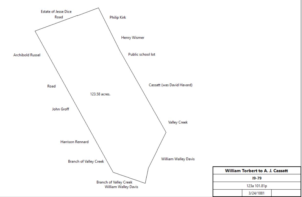
This tract formed to northwest portion of the Cassatt Chesterbrook estate |
A. J. Cassatt |
|
1883 |
465a 3r 18p |
|
Breou’s atlas |
|
|
|
|
|
|
Table G.1.2.a
|
Hannah Kugler, admistrator of the estate of John Kugler |
Reuben Coffman |
12/15/1876 |
4a + 6a |
$180 + $1,050 |
V8-420 |
Hannah Burney (nee Kugler) |
Reuben Coffman |
6/7/1879 |
7a 70p |
$111 56c |
X9-292 |
Reuben & Ida Coffman |
J. Rushton Griffith |
10/1/1894 |
7.37a + 4a |
$1,500 |
D11-588 |
J. Rushton & Mary Griffith |
Charles H. Kirk |
5/27/1912 |
11.37a |
$1,800 |
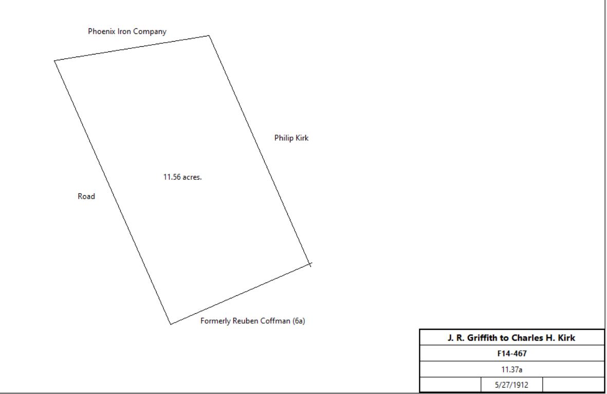
F14-467 |
 |
C. Harry Kirk |
|
1912 |
11a |
|
atlas |
|
Table G.1.3 – Samuel Given Quarry
|
From |
To |
Date |
Area |
Cost |
Reference |
|
|
|
|
|
|
Albert & Matilda Davis |
Hugh & John McInnes |
7/23/1872 |
11a 122p |
$3,000 |
D8-244 |
Walter McInnes, The Pennsylvania Company for Insurances, executors of the will of John McInnes |
Samuel Given |
1/11/1915 |
11a 122p |
$2,000 |
S14-408 |
|
|
|
|
|
|
W. E. Johnson Inc. |
Warner Company |
2/15/1957 |
|
|
B29-526 |
W. Ellis & Emma Johnson |
|
3/12/1965 |
|
|
G36-339 |
|
|
|
|
|
|
Emma H. Johnson & National Bank of Chester County Trust Company |
|
12/29/1965 |
53.958a |
$165,000 |
U36-297 |
|
|
|
|
|
|
Warner Company |
30 Fathoms |
6/1/1978 |
|
|
B53-399; not found |
30 Fathoms |
Warner Company |
6/30/1980 |
10.808a |
$34,500 |
Y56-380 |
Warner Company |
Quarry Associates |
5/22/1984 |
37.518a + 16.021a |
$1.95M |
M63-208 |
Mack-Cali Pennsylvania Realty Associates |
Westlakes Land KPG |
8/26/2013 |
not given |
$420,000 |
8801-698 |
|
Table G.1.4 – Howellville
|
From |
To |
Date |
Area |
Cost |
Reference |
|
|
|
|
|
|
Thomas & Sarah Davis of Coventry |
David Wilson |
4/8/1792 |
2a 24p |
£16 |
H2-375; from table G.1 above |
David Wilson and Joseph Caskey, executors of the will of David Wilson, senior |
William Walley |
4/4/1829 |
2a 24p |
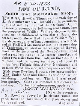
$831 |
C4-10 |
 |
|
|
Table G.2 – John Havard tract
|
From |
To |
Date |
Area |
Cost |
Reference |
|
|
|
|
|
|
David Powell of City of Philadelphia |
John Havard Sr. of Philadelphia County |
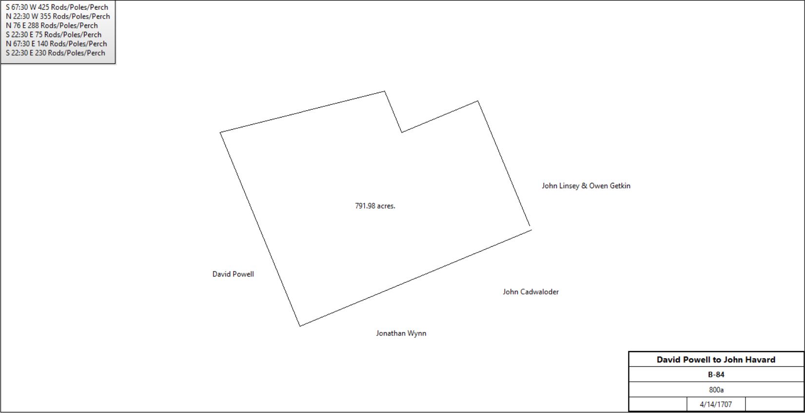
4/14/1707 |
800a |
£200 |
B-84 |
 |
John Havard Sr. |
Samuel Havard |
5/14/1763 |
200a |
5s plus £10 / year rent |
N-196 |
John Havard Sr. |
David Havard |
1766 |
300a |
|
O-363 see table G.2.1 |
John Havard Sr. |
Anne, Hannah & Sarah Havard |
8/18/1766 |
110a |
5s |
P-412 deed of gift |
John Havard Sr. |
John Havard Jr. |
1770 |
|
|
Estate #2551 see table G.2.2 |
|
|
Table G.2.1 David Havard Farm
|
From |
To |
Date |
Area |
Cost |
Reference |
|
|
|
|
|
|
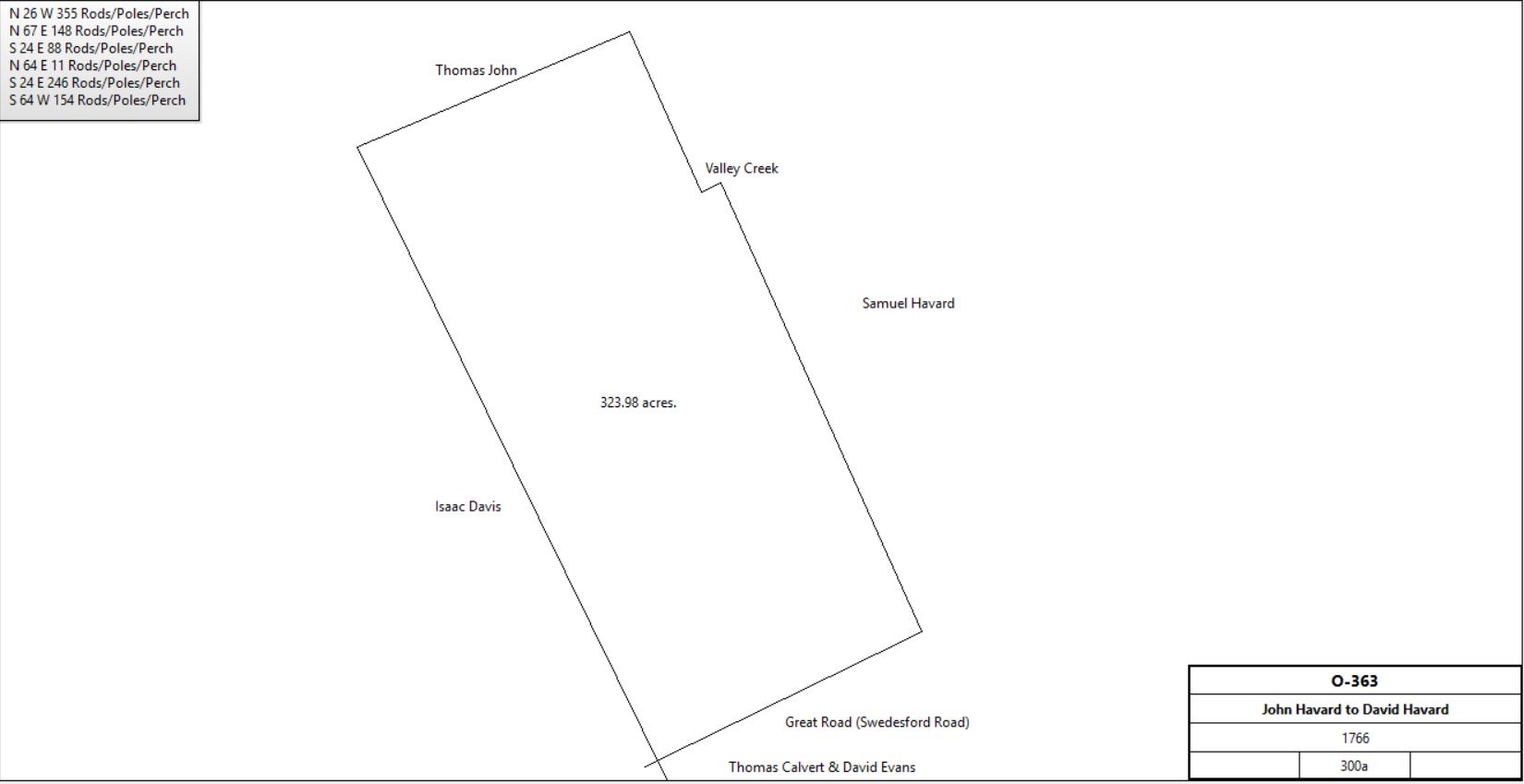
John Havard Sr. |
David Havard, second son |
1766 |
300a |
|
O-363 |
 |
David Havard |
|
1798 |
300a |
|
Glass tax |
David Havard |
|
1873 |
|
|
Witmer’s Atlas |
David & Eliza Havard |
Havard Walker & John M. Wilson, in trust for creditors of David Havard |
9/24/1878 |
|
|
Assignment; Miscellaneous 17-288 |
Harvard Walker & John M. Wilson |
David Havard |
3/1/1880 |
343a 47p + 4a 100p + 24a |
$1 |
G9-155 |
David & Eliza Havard |
Alexander J. Cassatt |
3/19/1881 |
342a 36.37p |
$21,728 41c |
I9-69 |
David & Eliza Havard |
Alexander J. Cassatt |
6/17/1881 |
25a |
$2,750 |
N9-128 |
A. J. Cassatt |
|
1883 |
468a 3r 18p |
|
Breou’s Atlas |
A. J. & Lois Cassatt |
William Rennyson |
5/6/1890 |
2.635a |
$790 50c |
P10-368 |
William & Sarah Rennyson |
George Tobler |
11/21/1890 |
14.099a |
$500 |
V10-18 |
|
Table G.2.2 - John Havard Jr. Farm
|
From |
To |
Date |
Area |
Cost |
Reference |
|
|
|
|
|
|
John Havard Sr. |
John Havard Jr. |
1770 |
|
|
Estate #2551 |
Mary Havard |
William Davis |
c. 1790 |
|
|
Married |
John Havard |
|
1795 |
181a |
tax |
|
John Havard Jr. |
Mary Davis during her life, then John Havard Davis on reaching 21. |
1797 |
|
|
Estate #4594 |
William Davis |
|
1798 |
229a |
|
Glass tax; Stone 30’ x 18’, Barn, Wagon House |
William Davis |
|
1810 |
|
|
Road 1810b plan |
Advertisement Chester and Delaware Federalist, 1817
“stone dwelling house, 32’ x 26’, well of good water near door (supplied from stream), a stone milk house supplied with water from a well. A frame barn with log addition (holding up to 20 tons of hay), lime kiln, limestone quarry, 2 apple orchards, fields and meadows of 5,6,7 and 8 acres each, good chestnut rail fences, fields well set with clover, green grass, and timothy, 10 acres of timber”
Advertisement Village Record 5/9/1819
“the finest limestone valley land with a great proportion of wood. It is well watered by a stream flowing through it, and running by the house. The land is in a high state of cultivation, and is conveniently laid off into fields, and under good fence.” |
John Havard Davis |
|
1819 |
|
|
Bankrupt; see The Quarterley article Spiritualism and a Contested Will |
John Havard Davis |
Edward Siter, Israel Davis, Joshua Jones |
|
|
|
In trust for creditors. |
Edward Siter, Israel Davis, Joshua Jones |
William Davis |
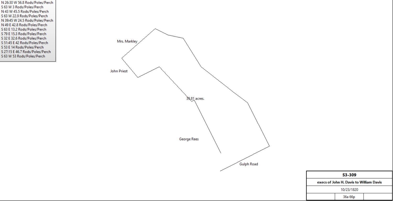
10/23/1820 |
36a 66p |
$6,400 |
S3-309 |
 |
John Havard Davis |
|
1821 |
|
|
died |
Mary Davis |
|
1848 |
|
|
died |
William Davis sr. |
|
1848 |
|
|
Died; no will |
William Davis sr. |
William Davis jr. |
July 1856 |
170+a |
|
Distribution of estate |
William Davis jr. |
|
1879 |
|
|
Died; no will, beneficiaries Mary, Rebecca, & Cyrus H. Davis |
Cyrus H. Davis |
Mary & Rebecca Davis |
1880 |
170+a |
|
Deed of release |
Mary & Rebecca Davis |
Cyrus H. Davis |
1880 |
Another tract |
|
Deed of release |
Mary Davis |
Rebecca Davis |
1880 |
175a |
|
Died; Estate #23142 & Estate #19408 |
Rebecca Davis & estate of Mary Davis |
|
1881 |
219a |
|
Breou |
Rebecca Davis |
Cyrus M. Davis |
9/24/1893 |
175a |
|
Died; Estate #24195 |
Execs of Rebecca & Mary Davis |
David Havard |
4/2/1894 |
170a |
$11,200 |
F11-482 |
David Havard |
|
1897 |
219a |
|
Atlas |
David Havard |
|
4/1898 |
|
|
died |
C. Wesley Talbot, executor of the will of David Havard |
Lawrence McCormick |
4/2/1903 |
178a 14p |
$13,356 58c |
K12-274 |
Cyrus M. Davis |
Amanda Jones & Debbie B. Jacobs |
5/11/1908 |
|
|
Estate, Cayuga, NY? |
|
Lawrence McCormick |
1910 |
|
|
Farm renamed Cressbrook Farm |
Lawrence McCormick |
|
9/7/1912 (will 5/6/1912) |
|
|
died |
Estate of Lawrence McCormick |
|
1912 |
178a 107p |
|
Mueller’s atlas |
Execs of Lawrence McCormick |
H. Graham Rambo |
10/10/1913 |
|
$32,768 10c |
K14-498 |
H. Graham Rambo |
Thomas Royal |
12/1/1913 |
178a 14p |
$1 |
R14-73 |
Thomas & Lillian Royal |
Henry Woolman |
3/9/1926 |
178a 14p |
$1 |
Y16-382 |
University of Pennsylvania |
|
1933 |
177.95a |
|
Atlas |
Henry Woolman |
University of Pennsylvania |
1939? |
|
|
|
University of Pennsylvania |
|
1963 |
218.2a |
|
Atlas, Cressbrook Farm |
University of Pennsylvania |
Fox Company |
1974 |
|
|
|
|
|
Table G.2.3 – Samuel Havard Farm
|
From |
To |
Date |
Area |
Cost |
Reference |
|
|
|
|
|
|
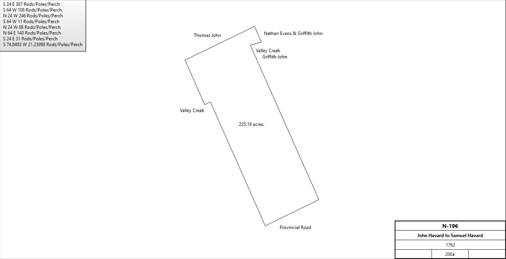
John Havard Sr. |
Samuel Havard |
5/14/1763 |
200a |
5s plus £10 / year rent |
N-196 |
 |
Samuel Havard |
|
1798 |
200a |
|
Glass tax;
|
Owner: Samuel Havard;
Occupier: Samuel Havard;
House: Stone 27' x 21', 2 floors
Windows: 3 windows with 24 panes
1 window with 20 panes.
5 windows with 15 panes.
2 windows with 4 panes.
Other buildings: Stone addition 26' x 16', 1 floor; Stone Kitchen 24' x 16'; Stone Springhouse 12' x 10'; Stone Springhouse 10' x 8'; Stone Barn 47' x 27'; Stone Waggon House 20' x 20'; Dwelling House 18' x 13'.
Area of tract: 200 acres. |
Samuel Havard |
John Havard Davis |
11/21/1808 |
|
|
Estate #5512 |
Sarah Havard |
Benjamin Havard, Jonathan Miller, Samuel Jacobs |
2/27/1809 |
|
$4 |
C3-436; release of any title to Samuel Havard’s property (presumably in order for Benjamin to obtain a mortgage). |
Ad in Village record, 9/22/1819
“The farm is in the Great Valley, the middle branch of the Valley Creek passing through it. 110 acres of the land is first rate woodland, the residue is of the finest quality of Limestone Valley Land, very highly improved, and divided into convenient fields and well fenced; with a large and good orchard on it. The farm is considered one of the finest and best in Chester County.”
|
Sheriff, Est. of John Havard Davis |
John Sharpless |
10/18/1819 |
250a |
$20,169 |
R3-126 |
Heirs of John Sharpless |
Elijah Lewis |
4/1/1836 |
249a 18p |
$18,945 |
L4-444 |
Elijah & Esther Lewis |
David Wilson |
4/1/1836 |
100a, part of 249a |
$7,605 |
N4-109 |
Elijah & Esther Lewis |
William Ritter |
3/25/1839 |
149a |
$14,252 50c |
T4-191 |
William Ritter |
|
6/18/1866 |
|
|
OC 15353 |
Exec. Of William Ritter |
David Havard |
3/28/1868 |
147a |
|
P7-79 |
David Havard |
Sarah Wilson |
3/28/1868 |
147a |
|
L7-293 |
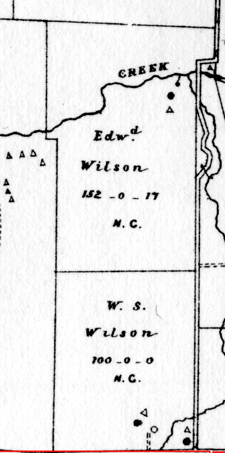
Edward Wilson |
|
1883 |
132a 17p |
|
Breou’s Atlas |
W. S. Wilson |
|
1883 |
100a |
|
Breou’s Atlas |
 |
Sarah Wilson |
Henry & Mollie Wilson |
2/13/1900 |
½ of 147a |
|
Estate #26647 |
Mollie L. Wilson |
Henry Wilson |
2/7/1902 |
½ of 147a |
|
I12-71 |
Henry Wilson |
Henry Woolman |
3/5/1929 |
149a |
|
Z17-21 |
Henry Woolman |
Edward Woolman |
12/30/1932 |
148.196a |
|
Y18-85 |
Edward Woolman |
Henry Woolman |
12/27/1933 |
148.196a |
|
E19-70 |
Henry Woolman |
University of PA |
10/11/1939 |
148.196a |
|
Z19-174 |
Henry Woolman |
University of PA |
10/11/1939 |
177.95a |
$1 |
G20-278; from table g.2.2 above |
Trustees of the University of Pennsylvania |
Commonwealth of Pennsylvania |
11/3/1975 |
30.83a |
$375,000 |
V46-214; parts of Z19-174 and G20-278; Lafayette's quarters |
|
Table G.2.4 – Anne, Hannah & Sarah Havard
|
From |
To |
Date |
Area |
Cost |
Reference |
|
|
|
|
|
|
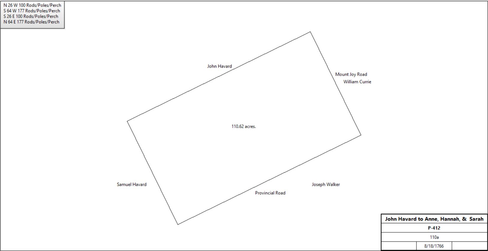
John Havard Sr. |
Anne, Hannah & Sarah Havard |
8/18/1766 |
110a |
5s |
P-412 deed of gift |
 |
Hannah & Sarah Havard |
|
1798 |
100a |
|
Glass tax; neighbour William Davis |
Hannah Havard |
|
1799 |
100a |
|
1799 county tax |
Hannah Havard |
Samuel Havard Davis |
1805 |
|
|
Will |
Sarah Havard |
Benjamin Havard |
1810 |
|
|
Will |
Benjamin Havard |
David Havard (son) |
1823 |
300a |
|
Will |
Benjamin Havard |
Susanna Havard (daughter) |
1823 |
76a |
|
Will, willed by aunt Susanna Havard |
William Roberts of Schuylkill township |
Susanna Havard |
3/16/1841 |
|
|
Marriage |
William Roberts |
|
1843 - 1860 |
71a & 11a |
|
Taxes |

1850 census |
W. Roberts |
|
1860 |
|
|
Kennedy Map |
Wm. Roberts |
|
1873 |
|
|
Witmer’s Atlas |
Wm. Roberts |
|
1883 |
80a 1r 17p |
|
Breou’s Atlas |
Estate of William Roberts |
|
1897 |
|
|
Railroad atlas |
Susanna M. Roberts |
|
4/16/1903 or 4 |
|
|
Died; Chester County Archives |
Estate of William Roberts |
|
1912 |
|
|
Lakiron Farm, Mueller’s Atlas |
S.M. & Clarence Roberts |
J. M. Walker |
1922 |
|
|
|
Jesse Walker |
Ralph M. Hunt (cousin) |
1930 |
|
|
|
Ralph M. Hunt |
|
1933 |
110a |
|
Green Valley Farm, atlas |
John A. Yohn |
Ralph M. Hunt |
Early 1940s |
|
|
|
John A. Yohn |
|
1950 |
|
|
Atlas |
John A. & Mae W. Yohn |
Tredyffrin township school district |
12/18/1963 |
|
|
O35-602 |
John A. & Mae W. Yohn |
Archbishop of Philadelphia St. Isaac Jogues Parish |
8/27/1970 |
|
|
N39-588 |
John A. Yohn |
Picket Post Village Incorporated. |
8/21/1973 |
|
|
U41-211 |
|
