Click on an image to see a higher resolution version
Title
Photographer
Date
Direction
Reference
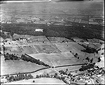
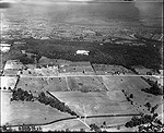
Yellow Springs Road and Mount Misery
Dallin
1927
looking north
Dallin #03300; courtesy of Hagley Museum
Dallin #03303; courtesy of Hagley Museum
From above route 202
Findeisen
10/08/1983
looking east
Findeisen #2009223_06_F21courtesy of Hagley Museum
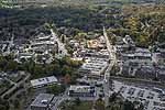
Lancaster Avenue is center of photo
Roger Thorne
10/15/2015
looking south
courtesy of Roger Thorne