TE History Home : Easttown Land Deeds : Use the links at left of the article to return.
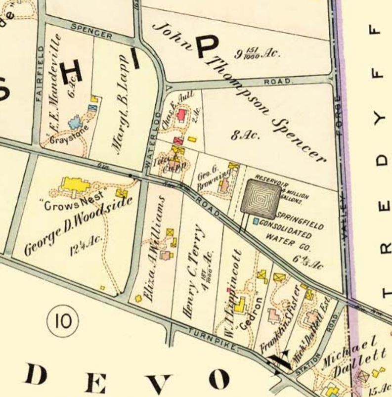
Easttown Digital Archives

Table 5 Shardlow (east) tract


Note: in these deed histories distances are quoted in perches (p) of length 16.5 feet. Areas are quoted in acres (a) and square perches (p). There are 160 square perches to an acre. In a few cases roods (a quarter of an acre) are also used.

Copy of deed obtained
Plan created 1777 land owner
1796 land owner
1777 and 1796 land owner

Table 5 Shardlow (east)

From

To

Date

Area

Cost

Reference


William Penn

William Shardlow & William Wood

12/5/1684 (surveyed)

3380a of 5000a quoted in B-25


Phila. Deed G-1-222?

William Wood

Joseph Wood

1690?

Half of 3380a


Inheritance; partition requested;

William Shardlow


1690?

Half of 3380a


partition requested;


From

To

Date

Area

Cost

Reference


JohnWightman et al (heirs of William Shardlow?)

Richard Harrison

6/6/1740


Phila. Deed GI-222

Richard Harrison

Samuel Harrison (son)

9/11/1746 (will)


Died, inheritance

Samuel Harrison

Cornelia Bridges

4/12/1747

1000a


G-237 (mortgage)

Table 5.1 Southeast Corner of Easttown

From

To

Date

Area

Cost

Reference


Samuel Harrison

Humphrey Wayne

4/15/1748

150a


Deed not found; Quoted in F2-83

Humphrey Wayne

John & Abraham Wayne

5/22/1756

150a


Deed not found; Quoted in F2-83

John & Abraham Wayne

Isaac Wayne

6/22/1756


Deed not found; Quoted in F2-83

Isaac Wayne

Anthony, Hannah & Ann Wayne

1776


Died intestate

Anthony & Mary Wayne and William & Ann Hayman

Samuel & Hannah Van Leer

4/6/1776

150a

5s

W-280

Samuel & Hannah Van Leer

General Loan Office of PA

11/23/1785


£100

Philadelphia mortgage; defaulted on third payment

Sheriff

William Hayman

4/27/1789


£820

F2-80

Elizabeth Wayne

Samuel Vanleer

7/5/1790

150a

£100

F2-86; release of Dower

William & Ann Hayman

George Adams

7/5/1790

150a

£900

F2-83

George Adams


1796

150a


County Tax; Stone House, Spring House, Frame Barn

George & Margaret Adams

Mordecai Davis

3/7/1805

150a

$6,124 50c

Y2-305

Mordecai & Jennis Davis

Samuel Taylor

12/23/1806

75a 97p

$3,225 25c

A3-391

Sheriff (George Adams et al)

Alexander Kenedy

1811


F3-252

Rachel Miles nee Adams

Mordecai Davis

2/4/1811


$748 37c

E3-390; release

Samuel & Ann Taylor

Nathan Lewis

3/20/1813

75a 97p


H3-198. Actually 81a by description. Church lot in Newtown?

Nathan Lewis

George Phillips

3/18/1818

81a 67p


Q3-22

James McMonegle


1883

60a 16p


Breou

Estate of J. Rogers


1883

18a


Breou


Abraham Bittle

Samuel Griffith

1801


T2-625; no Chester County sale deed

Samuel Griffiths


1813


By H3-198

Hugh J. Brook

Zimmerman Suplee

1843


Y4-122

Zimmerman and Hannah P. Suplee

William Suplee

1845


I5-1

William Suplee


1850

50a + 6a (unimproved)


Agricultural Census

William Suplee


1860

57a


Agricultural Census

William Supplee


1883

53a 1r 17p


Breou


Zimmerman Suplee


1850

27a


Agricultural Census

Zimmerman Suplee


1860

28a


Agricultural Census

Zimmerman Supplee


1874


Died testate

Hannah Supplee


1883

23a 5p


Breou


Mordecai Davis


1813


By H3-198


Table 5.2 Northeast Corner of Easttown

From

To

Date

Area

Cost

Reference


Thomas & Mary McKean

Alexander Boyd, James Murdock, James Blair

6/6/1772


No Chester County deed found. No McKean purchase deed found.

Alexander Boyd, James Murdock, James Blair

Joseph Gilbert

7/6/1772


No Chester County deed found


Joseph Gilbert

Mary Nicholas

2/10/1779

6a 12p

£60

V-657; no sale deed; in 1787 tax records; not in 1791 tax records


Joseph & Euphemia Gilbert

Judith Rees

1779

5a 9p

£40

T2-596; West side of K3-76

Judith Rees


1807


Died intestate

Judith Rees decd.

Jacob Aden

1808


B3-239 deed poll, no sale deed, not in 1810 taxes

Dr. Okie


1883


Breou

J. M. Thompson


1883


Breou


Joseph Gilbert

Ann Brown

2/10/1779

109a

£2200

Z-171

Ann Brown

Benjamin Brown, son

1803


Died

Benjamin Brown

John Havard Davis

4/1/1814

109a


K3-76. Tredyffrin on 2 sides

Cromwell Pearce, sheriff, debt of John Havard Davis

Thomas & Nathan Lewis

10/18/1819

5a

$160

Sheriff's deed 2-166

Nathan Lewis et al

John Yerkes & Phineas Paist

9/15/1857

5a 12p


T6(141) - 184

Yerkers & Paist


1883


Breou, tip of NE corner

John Yerkes

Rush Beaumont

1/14/1887

Half part of 5a 12p

$300

D10-444


Sheriff (goods of John Havard Davis)

Alexander Finley

10/18/1819

93a 143p

$2779

N4-69; messuage

Sheriff (goods of John Havard Davis)

Alexander Finley

11/12/1819

96p

$551

N4-70

Mary Findley, administrator of the estate of Alexander Findley

John Leamy

4/1/1851

93a 143p

$2,887 23c

N5-243

Stephen Leamy and George Lewis, executors of the will of John Leamy, & Hannah Leamy, widow

Eber Beaumont

4/1/1865

88a 3r 7p

$5,238 82c

A7-90; messuage

Estate of Eber Beaumont


1883

104a 1r 17p


Breou

H. Brown


1883

15a 3r 14p


Breou


Rush & Martha Beaumont & Rush Beaumont as trustee of the estate of Eber Beaumont

R. B. Okie

6/29/1886

88a 3r 7p

$2,763 90c

D10-178; messuage

Richardson B. & Mary Okie

Rush Beamont

12/16/1886

0.181 a

$217 20c

E10-252; no buildings mentioned

R. B. & Mary Okie

G. Genge Browning

6/17/1887

2/3 part of 3.071a - 0.181a

$5,000

G10-105; buildings

Dr. R. B. & Mary Okie and G. Genge & Amy Browning

Ida Estelle Capp

6/10/1892

1.237 a

$3,166 66c (Okie) & $6,333 33c (Browning)

B11-15

Ida Capp


1912


Muller’s Atlas

Table 5.3 The Robert McClenachan tract and Glassley Commons

This follows Franklin Burns ‘the Story of Glassley Commons’, TEQ vol. 5, #3 but since I cannot understand most of the deed history at this stage I am omitting it.

From

To

Date

Area

Cost

Reference


Samuel Harrison

Hannah Thomson (sister) and nieces Amelia McClenachan and Mary Mifflin (nee Harrison)

11/21/1770

780a


Will. Proved 3/23/1774

Jonathan Mifflin (husband of Mary deceased)

Robert McClenachan

9/13/1791

768a

5s

H2-368; release as tenant. + 2 other tracts in Novington township

Charles and Hannah Thompson

Robert and Amelia McClenachan and Jonathan Mifflin (husband of Mary – then dead?) and after his death to daughter Mary

9/18/1791

One third part of 780 acres


Mary Mifflin

Amelia McClenachan


Died

Robert Ralston (assignee of creditors of Robert McClenachan, bankrupt)

John Taylor

1/15/1789

one half part of 763a (Easttown), & 2 tracts in Norrington

£121

F2-286

John & Ann Taylor

Robert McClenachan

1/20/1789

one half part of 763a (Easttown), & 2 tracts in Norrington

£121

F2-288

Table 5.3.1 Mifflin Tract

From

To

Date

Area

Cost

Reference


Robert McClenachan

Jonathan Mifflin, late husband of Mary who was Amelia’s sister

9/13/1791

160a

5s?

G2-91; southern section of the tract

Jonathan Mifflin

Adam Siters

5/2/1794

31a 146p

£270 13s

L2-62

Jonathan Mifflin

Richard Butler

5/2/1794

128.4a

£692 7s

L2-154

Richard Butler


1794


died; administration

Magret Butler


1796

120a


County tax; Stone House, Log Barn

Execs of Richard Butler

William Kenney

11/14/1809

80a

$1,400

B3-514

William & Lydia Kenney

Emmor & Eber Beaumont

4/1/1839

70a

$5,880

R4-305

Patrick Lowery


1883

70a


Breou

Table 5.3.2 Stirk – Scott tract

From

To

Date

Area

Cost

Reference


Robert McClenagan

Frederick Houseman

12/1/1801

32.25a

£475

T2-832; from table J

Frederick Houseman

Robert McClenagan

7/1/1802


W2-110; altering road at side of tract

Frederick & Elizabeth Houseman

Samuel Stirk

3/15/1803

32.25a – 4a + to Watkin Watkins

£437 10s

X2-117; mentions buildings but no messuage

Cromwell Pearce, Sheriff, property late of Samuel Stirk deceased

Abel Rees

5/14/1819

30a


Sheriff’s Deed book 2-152. Mentions messuage

Execs of Abel Rees

Alexander Findley

6/17/1822

30a

$637 50c

N4-518

Admins of Alexander Findley

Henry Scott

3/31/1851

2a 4p

$400

O5-290

Admins of Alexander Findley

Henry Scott

3/31/1851

30a

$1,050

O5-292

Henry Scott

Charles Paist

2/8/1882


P9-40

Charles Paist

Lemuel Coffin and Joseph B. Altemus

3/17/1882

6.132a

$4,599

P9-432

Henry Scott


1883

10a 2r 7p


Breou’s atlas

Table 5.3.3 Other information

From

To

Date

Area

Cost

Reference


Joseph C. Smith


1851


Various sources

Joseph C. Smith


1850

30a?


Agricultural Census

Joseph C. Smith


1873


Retired

F.L. and R.B. Smith


1883

123a 3r 39p


Breou