TE History Home : Use the links at left of the article to return.

Upper Merion Digital Archives

Valley Forge National Historical Park

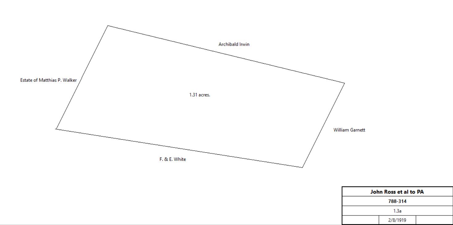
Note: in these deed histories distances are quoted in perches (p) of length 16.5 feet. Areas are quoted in acres (a) and square perches (p). There are 160 square perches to an acre. In a few cases roods (a quarter of an acre) are also used.


Deed Files


Deed list copied from Chester County deed V59-484

Encampment Interior

From

To

Date

Area

Cost

Reference


Map tile #8 - Matthias Walker estate

M. P. Walker


1906


Park map

M. P. Walker estate


1912


Mueller's Atlas

image 770-344 not found
Annotated extract from Mueller's 1912 atlas

Heirs of Matthias P. Walker

Commonwealth of Pennsylvania

3/25/1918

21.89a + 5.86a + 42.53a

$17,000

766-293; tract #3

Map tile #11

John Albin Shaw, executor of the will of Sarah Ann Shaw

Louie R. Hallman

1/14/1901


468-396; see WashingtonsHQ.html for earlier history

Louie R. Hallman

John Hallman, husband, & Mary E. S. Evans, sister

6/28/1908


died

John Hallman & Mary E. S. Evans

Commonwealth of Pennsylvania

6/13/1919

22.765a

$25,396 88c

790-560

Map tile #13

Charles Johnson


1893


Atlas

Charles Johnson

Commonwealth of Pennsylvania

1897


deed not found

Map tile #14

B. McMenamin


1893


Atlas

David McMenamin and relatives

Commonwealth of Pennsylvania

11/7/1905

27a (calculated)


544-212

Map tile #21

William U. Hensel


1912

200a


Mueller's Atlas

Hensel Tract image not found

David & June Dallas Commonwealth of Pennsylvania 6/6/1919 191.65a $46,943 791-499

791-499 image not found

Map tile #27

Mary Rees

Violetta M. Kennedy

5/18/1861


221-274

Violetta M. Kennedy


1897


Park Map

Violetta M. Kennedy


11/11/1903 (will proved)


died

Violetta R. Kennedy et al, exectrix of the will of Violetta M. Kennedy

Frank Kwaterska

3/12/1910

14.5a

$1,450

629-196

Frank Kwaterska


1912


Atlas

Frank Kwaterska

Girolemo Giovannini

12/12/1916

14.5a

$3,500

751-403

Girolemo Giovannini

Commonwealth of Pennsylvania

6/3/1919

15.174a

$5,374 16c

793-226

image 793-226 not found
Annotated extract from Mueller's 1912 atlas

Map tile #29 - Phoenix Iron Company

From

To

Date

Area

Cost

Reference


Samuel I. Reeves

Phoenix Iron Company

4/19/1856


103-416

Phoenix Iron Company


1897


Park map

Phoenix Iron Company

Commonwealth of Pennsylvania

10/31/1941

13a 87p

$21,250

1435-401

image 1435-401 not found

Map tiles #39 & #40 - Joseph Mullen estate

From

To

Date

Area

Cost

Reference


Estate of Joseph Mullen

Commonwealth of Pennsylvania

5/18/1918

10.087a + 20.724a

$6,600

770-344

image 770-344 not found
Annotated extract from Mueller's 1912 atlas

Estate of Joseph Mullen

Commonwealth of Pennsylvania

6/9/1919

15.848a

$10,000

793-346

image 793-346 not found
Annotated extract from Mueller's 1912 atlas

Map tile #44 - Focht tract

Nathaniel Jones


1893


Atlas

Joseph Boyd et al, executors of the will of Nathaniel Jones

Hannah Focht

4/4/1904

18.22a

$2,559 70c

518-118

Hannah Focht

Commonwealth of Pennsylvania

8/1/1905

18.22a

$3,279 60c

540-94

Map tile #45

Nathaniel Jones


1893


Atlas

Estate of Nathaniel Jones

Commonwealth of Pennsylvania

1897


deed not found; see WashingtonsHQ.html for earlier history

Map tile #46

Sarah Ann Shaw

Commonwealth of Pennsylvania

1897


deed not found; see WashingtonsHQ.html for earlier history

Map tile #49 - Lewin tract

Violetta Kennedy Samuel Levin, George Thomas, Abram Levin 7/14/1903     506-319
George Thomas Samuel Levin, Abram Levin       546-152?
Samuel & Ella Lewin, Abraham Lewin Commonwealth of Pennsylvania 11/16/1906 14.804a $4,000 564-351

Map tile #50

Wm. M. Stephens


1893

165a


Atlas

William Taylor

Commonwealth of Pennsylvania

7/9/1918

66.06a

$25,750

774-4

Image 774-4 not found

Map tile #53

Thomas Cutler

Commonwealth of Pennsylvania

before 1912


deed not found

Map tile #54 - Davis tract

C. A. Davis


1893


Atlas

Mary E. S. Davis

Commonwealth of Pennsylvania

5/1/1924

59 acres

$22,484

1109-168

Map tile #57 - Asbestos Works

Violetta M. Kennedy

Asbestos Manfacturing Company

2/28/1903


528-904; tract a) below

W. U. Hensel

Ehret Magnesia Manfacturing Company

3/5/1910


623-455; tract b) below

Emma L. Spear

Ehret Magnesia Manfacturing Company

3/31/1917


756-267; tract c) below

Asbestos Works


1912


Atlas

Keene Building Products, successor to Asbestos Manufacturing and Ehret Asbestos

Keene Corporation

9/27/1974

a) 31.2a + 2a 85p; b) 1.343a; c) 5.69a + 4.8a

$1

4143-157

Keene Corporation

United States

10/13/1976

a) 31.2a + 2a 85p; b) 1.343a; c) 5.69a + 4.8a

$1,000,000

4149-300

Map tile #58 - Matthias Walker estate

M. P. Walker estate


1912


Atlas

Heirs of Matthias P. Walker

Commonwealth of Pennsylvania

3/25/1918

21.89a + 5.86a + 42.53a

$17,000

766-293; tract #1

Map tile #59 - Matthias Walker estate

M. P. Walker estate


1912


Atlas

Heirs of Matthias P. Walker

Commonwealth of Pennsylvania

3/25/1918

21.89a + 5.86a + 42.53a

$17,000

766-293; tract #2

Map tile #88

Elizabeth & Frances White

PA

7/30/1918

8.96a


773-221

773-221 image not found

Map tile #89 - Irwin tract

Elizabeth Irwin


1912


Atlas

Heirs of Elizabeth Irwin

PA

1/24/1924

3.415a

$4,250

1112-411

Map tile #90

Emma C. Spear


1912


Atlas

Emma L. Spear

Ehret Magnesia Manfacturing Company

3/31/1917


756-267; tract c) below

Asbestos Works


1912


Atlas

Keene Building Products, successor to Asbestos Manufacturing and Ehret Asbestos

Keene Corporation

9/27/1974

a) 31.2a + 2a 85p; b) 1.343a; c) 5.69a + 4.8a

$1

4143-157

Keene Corporation

United States

10/13/1976

a) 31.2a + 2a 85p; b) 1.343a; c) 5.69a + 4.8a

$1,000,000

4149-300

Map tile #91

Eliza Brittain


1912


Atlas

Eliza Brittain

PA


deed not found

Map tile #92

F. Powell


1912


Atlas

Ada Powell and Emma Powell Boynon

W. S. Garnett

10/13/1914


723-376

Franklin Powell et al

W. S. Garnett

10/29/1915


732-555

William Garnett

PA

1/31/1924

0.086a (Port Kennedy) + 3.879a

$29,000

1115-258

Map tile #93

Estate of John Wilkinson


1906


Park map

Archibald B. Irwin


1912

44 acres


Atlas

Valley Forge Park


1942


Park map

Map tile #94

Emma C. Spear


1912


Atlas

Emma L. Spear

Ehret Magnesia Manfacturing Company

3/31/1917


756-267; tract c) below

Asbestos Works


1912


Atlas

Keene Building Products, successor to Asbestos Manufacturing and Ehret Asbestos

Keene Corporation

9/27/1974

a) 31.2a + 2a 85p; b) 1.343a; c) 5.69a + 4.8a

$1

4143-157

Keene Corporation

United States

10/13/1976

a) 31.2a + 2a 85p; b) 1.343a; c) 5.69a + 4.8a

$1,000,000

4149-300

Map tile #95

Asbestos Works


1912


Atlas

Asbestos Works


1912


Atlas

Keene Building Products, successor to Asbestos Manufacturing and Ehret Asbestos

Keene Corporation

9/27/1974

a) 31.2a + 2a 85p; b) 1.343a; c) 5.69a + 4.8a

$1

4143-157

Keene Corporation

United States

10/13/1976

a) 31.2a + 2a 85p; b) 1.343a; c) 5.69a + 4.8a

$1,000,000

4149-300

Map tile #96

William U. Hensel

Eastern Real Estate

10/27/1911


661-441

Eastern Real Estate


1912


Atlas

Eastern Real Estate

PA

8/30/1943

30.4a

$6,080

1539-106

Map tile #97

Philip Boyer, sheriff

Ann Jones

8/15/1825


Ann Jones

John Busby

3/31/1828

12a 100p

$100

43-601

John & Jane Buzby

Thomas Vanderslice & Simon Autry

4/29/1831

12a 100p

$500

47-170

Thomas Vanderslice

Simon Autry


54-523

Simon & Rebecca Autry

Samuel A. Davis

4/3/1838

12a 100p

$1,000

54-524

Mary Davis

Alexander Cornish

2/3/1864

12a 100p

$900

132-176

Alexander Cornish

Catharine O'Connor

3/31/1877


236-70

Charles Henry Coster

Philadelphia & Reading railroad company

11/16/1896


418-402; tract #3 below

William M. Stephens

Gordon Chambers

11/9/1899

19a

$3,040

452-459

Catharine & Thomas O'Connor

Gordon Chambers

11/15/1899


452-462

Gordon Chambers

Reading Company

9/7/1901

19a + 12a 100p

$1

478-231; tracts #1 and 2 below

Reading Company


1912


Atlas

Reading Company

PA

8/30/1943

3.16a + 25.43a + 0.57a

$5,832

1539-101

Map tile #98 - Zulich tract

Geo. A. Piersol


1893


Atlas

J. Heston & Anna P. Todd Sarah S. Zulich 12/23/1895 tract #1 below   409-189
J. Heston & Anna P. Todd Sarah S. Zulich 4/1/1896 tract #2 below   412-198
William M. & Martha Stephens Sarah S. Zulich 7/16/1904 tract #3 below   522-150
Sarah S. Zulich   1912 10a   Atlas
Sarah S. Zulich Winifred & Amy Zulich 6/20/1917 5a + 5.08a + 8.1a $1 754-455
Winifred & Amy Zulich Washington Memorial Chapel 6/7/1927 15.38a $15,180 1018-316
Washington Memorial Chapel Commonwealth of Pennsylvania 06/26/1943 7.74a $23,500 1539-69

Map tile #99 - Stephens tract

Abijah and William Stephens, administrators of the estate of William M. Stephens

William Stephens


quoted in 163-195

Joseph B. Walker

William Stephens

10/7/1868

168a 47p

$18,545

163-195

Wm. M. Stephens


1893

165a


Atlas

William & Mary Stephens

Wm. M. Stephens

1/9/1896

96a 80p

$14,475

410-386

Wm M. Stephens


1912

46.5a


Atlas

Wm. M. Stephens

PA

10/9/1923

36.15a

$14,280

1199-1

PA


1942


Park map

Map tile #116

Wm. M. Stephens


1893

165a


Atlas

Mrs Thos. A. Garland


1912

3a


Atlas

Mrs Thos. A. Garland

PA


deed not found

PA


1942


Park map

Map tile #117 - Burk tract

Wm. M. Stephens


1893

165a


Atlas

Rev. Herbert Burk


1912

3a


Atlas

Eleanor & Rev. Herbert Burk

PA

10/29/1923

3a

$5,500

1116-194

Ella Hittall

Eleanor Burk

5/6/1924


919-175

Eleanor & Rev. Herbert Burk

PA

9/1/1931

0.38a

$4,096

1135-62

PA


1942


Park map

Map tile #118 - Star Redoubt

Wm. M. Stephens


1893

165a


Atlas

Star Redoubt image not found
from Valley Forge Commissioner's Minutes, 11/27/1897
when purchase of 1.143 acres approved

Wm. M. Stephens

PA


deed not found

PA


1912


Atlas

Map tile #119 - McMenamin tracts

Charles Johnson


1893


Atlas

David B. McMenamin

Mary McCarthy and Cecilia McMenamin, daughters; David B. McMenamin, son

11/30/1897


died

Mary & John McCarthy

Cecilia McMenamin and David B. McMenamin

4/24/1905

1/3 interest

31a 14p + 41a 113p - 25.456a

535-11

A. B. McMenamin


1912


Atlas

David. B. McMenamin

Amy McMenamin, wife

5/30/1916


died

Mary McCarthy and Cecilia McMenamin

Amy McMenamin

9/25/1919


release

Amy McMenamin, widow of David B. McMenamin

PA

12/10/1919

22.5a + 22.573a

$11,660

806-234

PA


1942


Park map

Map tile #120

Charles Johnson


1893


Atlas

Susanna M. Johnson


1912


Atlas

Susanna M. Johnson

Thomas Cutler


deed not found

Thomas Cutler

PA

10/27/1923

4.68a (calculated)


1117-119

1117-119 image not found

PA


1942


Park map

Map tile #121 - McMenamin tracts

Estate of David McMenamin Commonwealth of Pennsylvania 12/10/1919 25.5a + 22.573a $65,512 806-234


Map tile #131 - Camp school


William Davis


deed not found

William Davis

Samuel H. Davis


died intestate

Samuel H. Davis Upper Merion School District 8/17/1859 103p $100 115-343
Upper Merion School District Commonwealth of Pennsylvania 1/20/1920 0.64a $4,450 808-23


Map tile #132 - Frank Quigg

Frank Quigg Mary M. Patterson 2/22/1902     484-41
Mary Patterson Frank Quigg 4/13/1911 area not quoted $1,200 718-138
Frank Quigg Commonwealth of Pennsylvania 12/31/1919 0.19a $3,100 798-522

798-522 image not found


Map tile #133 - John Ross

Mary Smith Margaret Ross, daughter 2/23/1880 (will)     died
John Ross et al Commonwealth of Pennsylvania 2/8/1919 1.3a $900 788-314

788-314 image not found


Map tile #134 - Davis tract

C. A. Davis


1893


Atlas

Sheriff

Mary E. S. Davis

9/2/1897


Sheriff's deed 12-220

Mary E. S. Davis

Commonwealth of Pennsylvania

5/1/1924

50.63a + 18.1a

$22,464

D18-265


Map tile #135 - Hoover tract


Emeline Henry Hoover


Emeline Henry Hoover

Martha T. Stephens

2/20/1899


443-350; deed not available

William M. Stephens et al

Commonwealth of Pennsylvania

6/4/1924

50.63a + 18.1a

$15,300

1199-3