From |
To |
Date |
Area |
Cost |
Reference |
|
|
|
|
|
|
Commissioners |
Katherine Morgan |
9/9/1701 |
212a |
|
Patent A2-94; see survey request |
Katherine Morgan |
Griffith Jones (grandfather) |
2/3/1702 |
212a |
|
S-21 |
Griffith Jones |
David Jones |
2/6/1722 |
212a |
|
Will proved 1/11/1723 |
David & Joan Jones |
Alexander Owen, Griffith John, William Rees & John Davies |
11/16/1724 |
½a |
10s |
H-292; Baptist Church |
David Jones |
William Jones (son) |
9/25/1759 |
½ real estate, westerly end |
|
Will |
David Jones |
Levi Jones (son) |
9/25/1759 |
½ real estate, easterly end |
|
Will |
William Jones, Amos & Mary Jones |
Griffith Jones |
5/27/1771 |
112a |
|
R-544; see deed plan |
Levy Jones |
|
1798 |
99a |
|
Glass tax |
James McClean |
|
1798 |
109a |
|
Glass tax; wife 1 of 3 inheritors of Griffith Jones estate |
James McClean |
|
1799 – 1804 |
109a |
|
Tax |
James McClean |
|
1804 |
|
|
Died; estate #5167 |
Hannah or Joanna McClean (nee Jones), widow |
|
1805-1806 |
|
|
tax |
Partition of estate of Griffith Jones |
Catherine (Jones) & William Brown |
12/25/1804 (letters of admin.) |
113.25a |
|
Estate #5164; Catherine grand daughter of Griffith Jones II |
William Brown |
|
1806 – 1812 |
112a |
|
tax |
Catherine & William Brown |
George Beaver |
3/31/1812 |
34a |
$2346 |
G3-221 |

|
William Brown |
|
1812 – 1818 |
80a |
|
tax |
Levi Jones |
|
1817 |
|
|
Died, #6427 |
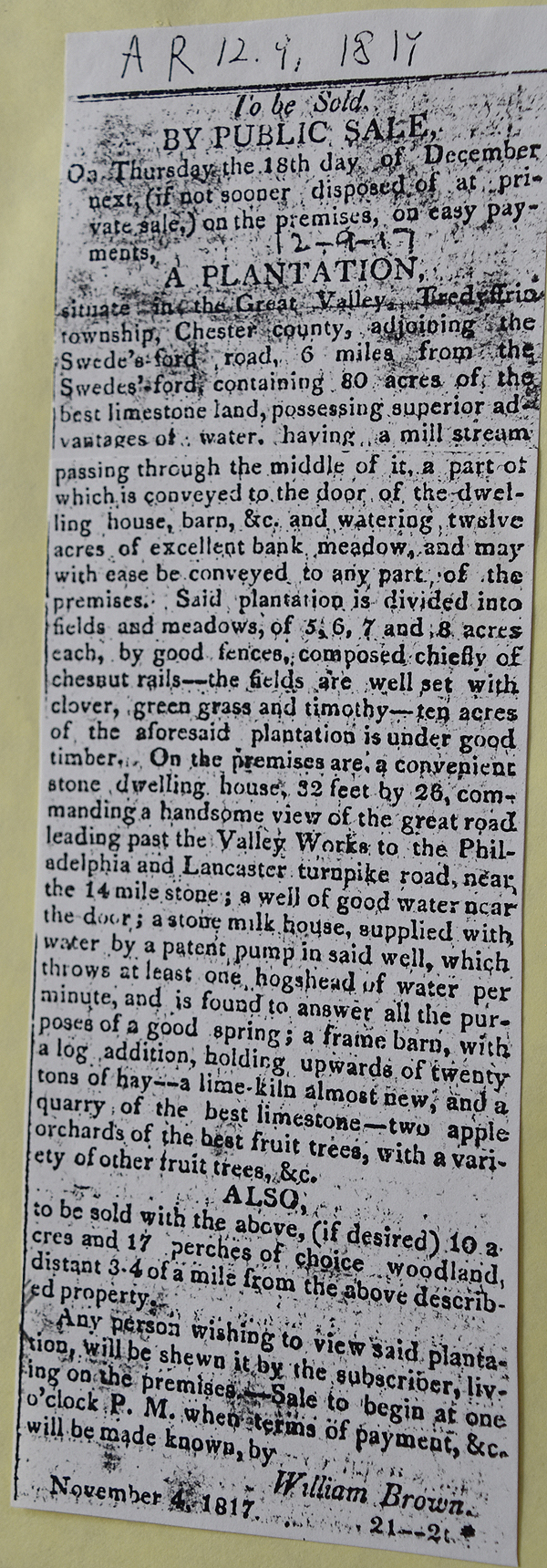
American Republican 12/9/1817
See Newspaper clipping in Document database for commentary
|
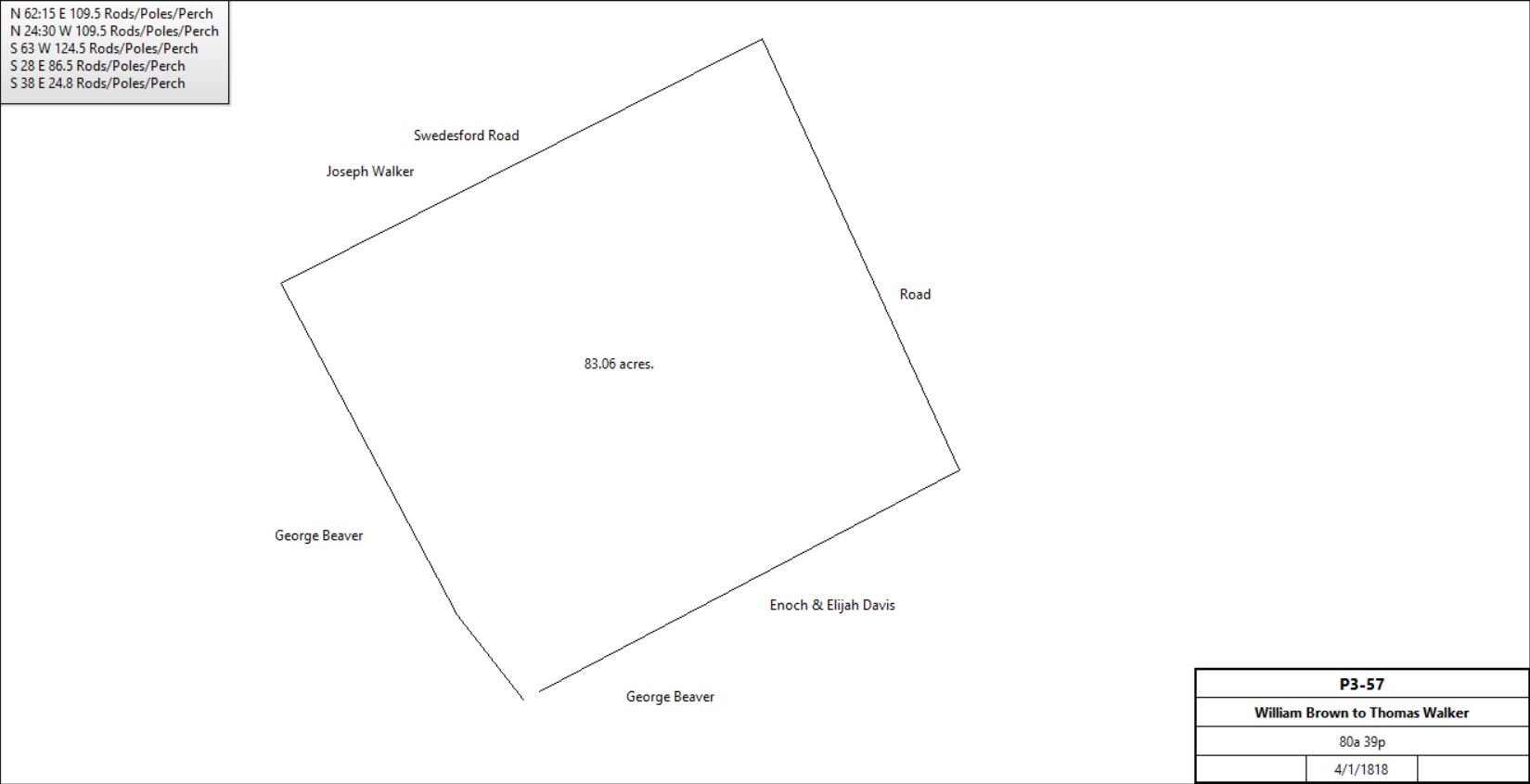
Catherine & William Brown |
Thomas Walker |
4/1/1818 |
80a 39p |
$7823 |
P3-57; see deed plan |
|
Thomas Walker |
Isaac Walker (son) |
1839 |
|
|
Died |
Isaac Walker |
|
1851 |
|
|
Right of Way for Chester Valley Railroad |
Isaac Walker |
George H. Beaver |
1881 |
Small portion |
|
|
George H. Beaver |
|
1883 |
117a |
|
Breou atlas (patent only covers part of this tract) |
William Farley |
|
1883 |
114a |
|
Breou atlas |
Isaac Walker |
|
1883 |
80a |
|
Breou atlas |
Isaac Walker |
|
1887 |
|
|
Died |
Adm. of Isaac Walker |
William H. Kemble |
1887 |
|
|
|
William H. Kemble |
Mary F. Kemble (wife, daughter of Isaac Walker) |
1891 |
|
|
|
|
Elizabeth K. Yarrow |
1902 |
|
|
|
|
Elizabeth K. Yarrow |
1902? |
Beaver portion |
|
|
|
George C. Shane |
1918 |
|
$65,000 |
|
|
Samuel & Jean Morris McDowell |
|
|
|
Lost in 1929 crash |
Sheriff |
Susannah Valliant |
|
|
|
|
Susannah Valliant |
Warren H. Wells |
1945 & 6 |
|
|
|
Warren H. Wells |
Richard Fox corp |
1966 |
|
|
|
Richard Fox corp |
Old Forge Crossing Associates. |
1969 |
|
|
See The History of Old Forge Crossing |
|
|
H-292 Deed. On 16 Nov 1724 David Jones, eldest son & heir of Griffith Jones, late of Tredyffrin, yeoman, dec. & Joan his wife, to Alexander Owen & Griffith John both of Chester County, yeomen, William Rees & John Davies both of Philadelphia County, yeomen. Whereas Katherine Morgan of Philadelphia, widow, by deed dated 3 Feb 1702 granted to Griffith Jones a tract in Tredyffrin containing 212 acres. Griffith Jones made his will dated 6 Feb 1722 & devised to his beloved son all his goods, chattels & lands, including the 212 acres. Now David Jones & Joan his wife for 10 shillings grant to Alexander Owen, Griffith John, William Rees & John Davies, a tract in Tredyffrin bounded by land of Lewis Walker, land late of Rowland Richards, land late of Edward Matthias (but late of Harry David) containing 1/2 acre. Signed David Jones & Joan Jones. Delivered in the presence of Richard Owen, John George & Lewis Williams. Recorded 30 Mar 1752.
R-544 Beginning at a post in line of Samuel Richards thence N64½°E along the Swedesford Road by land of Joseph Walker 164.3 perches to a post, thence S27°E by the other moiety of land allocated by said will to Levi Jones, 108 perches to a post, S63°W by William Melcher 159.8 perches to a post by the Baptist Meeting House, thence N27°W 18.6 perches to a stone, thence by said meeting house land S63°W 4.4 perches to a stone in the road from Mount Joy to Radnor Church, thence N27°W along said road by Samuel Richards 93 perches to the place of beginning.
|
