|
Note 1: in these deed histories distances are quoted in perches (p) of length 16.5 feet. Areas are quoted in acres (a) and square perches (p). There are 160 square perches to an acre. In a few cases roods (a quarter of an acre) are also used.
Note 2: the 490 or 500 acres of the Wright patent seems too small to cover the area of the tract. No other patent or a deed tree has been found for the area.
|
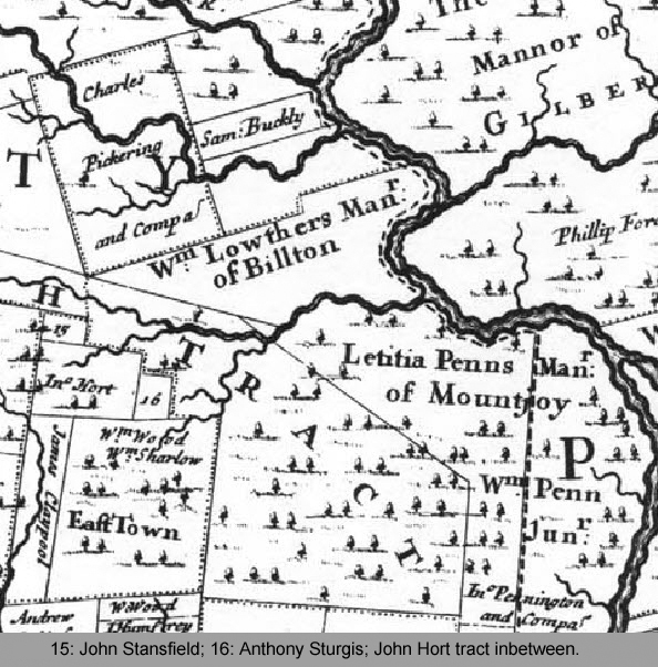
Thomas Holmes Map of 1687
|
|
From |
To |
Date |
Area |
Cost |
Reference |
|
|
|
|
|
|
Penn |
John Hort |
4/20/1685 |
1000a |
|
SW corner of Tredyffrin; overlaps Henry Wright patent |
John Hort |
Thomas Hort |
|
|
|
|
Thomas Hort |
Samuel Aktins & William Hearn |
|
|
|
Not conveyed |
Thomas Hort, Samuel Aktins & William Hearn |
John Worral & Philip Yarnall |
9/12/1699 |
1000a |
£60 |
A-244 |
|
William Penn |
Henry & Elizabeth Wright |
8/10/1682 |
500a |
5s |
L9-382 Lease. Land to be allocated |
William Penn |
Henry & Elizabeth Wright |
8/11/1682 |
500a |
? |
L9-383 deed. Land to be allocated |
Henry Wright |
Elizabeth Wright |
|
|
|
died |
Elizabeth Wright |
Henry Wright (grandson) |
6/26/1700 |
500a |
5s |
L9-385 Lease |
Elizabeth Wright |
Henry Wright (grandson) |
6/27/1700 |
500a |
|
L9-386 deed |
Henry Wright |
Philip Yarnall |
3/7/1702 |
|
|
|
Philip & Dorothy Yarnall |
William Evan |
12/16/1719 |
490a |
£110 |
L9-386 |
William Evans |
|
1721 |
|
|
County tax |
William Evans |
|
1722 |
|
|
County tax |
William Evans |
|
1724 |
|
|
County tax |
William Evans |
|
1725 |
|
|
County tax |
William Evans |
|
1726 |
|
|
County tax |
William Evans |
|
1729 |
|
|
County tax |
Philip Yarnall ux |
Richard Evan (son of William) |
9/10/1734 |
10a, Part of Wright 500a |
5s |
L9-389 deed of confirmation |
William Evan |
William Evans (100a) and Richard & David Evans (remainder, 400a) |
1/4/1734 (will proved in Phila.) |
|
|
Phila. Will E-314 |
Ellinor Evans |
|
1739 |
|
|
County tax |
David Evans |
|
1739 |
|
|
County tax |
John Humphrey |
|
12/19/1739 |
100a (part of 500a) |
|
See survey from 1739 |
John Humphrey |
|
1739 |
|
|
County tax |
John & Rachel Humphrey |
Joseph Mitchell |
12/31/1743 |
100a |
|
Deed not found |
Joseph & Mary Mitchell |
Samuel Morgan |
1748 or 1758 |
100a |
£160 |
G-370 & L-225 |
L-225 On 22 Dec 1758 Joseph Mitchell of Tredyffrin, cordwainer, & Mary his wife to Samuel Morgan of Radnor, yeoman. Whereas Joseph Mitchell by virtue of a deed made by John Humphreys & Rachel his wife, became seized in a tract of land bounded by land of Thomas Hubbert, Thomas James, Lewelyn David, John David, & William Sharp containing 100 acres. Now Joseph Mitchell and Mary his wife for £250 granted to Samuel Morgan all the 100 acres of land as described. Signed Joseph and Mary Mitchell. Delivered in presence of John Thomas, Lavallin Barry & William Evans. Recorded 11 Apr 1759.
G-370 Lease & Release. On 17 & 18 Nov 1748 Joseph Mitchel of Tredyffrin, cordwainer, & Mary his wife, to Samuel Morgan of Radnor, yeoman. " Whereas John Humphrey & Rachell his wife by deed dated 31 Dec 1743 granted to Joseph Mitchel a tract in Tredyffrin bounded by land of Thomas Hubbard, Thomas James, Llewelyn David, John David & William Sharp, containing 100 acres. Joseph Mitchel & Mary his wife for £160 granted to Samuel Morgan the said tract containing 100 acres. Signed Joseph Mitchel & Mary Mitchel. Delivered in the presence of John Jerman, Hugh Griffith & William Evans. Recorded 13 Jan 1748/9.
|
David Evans |
Joshua Evans |
1751 |
|
|
Will Phila. I-461 |
Richard Evans |
|
1760 |
200a |
|
Tax |
Richard Evans |
Joel Evans |
10/20/1762 |
200a |
|
Died intestate |
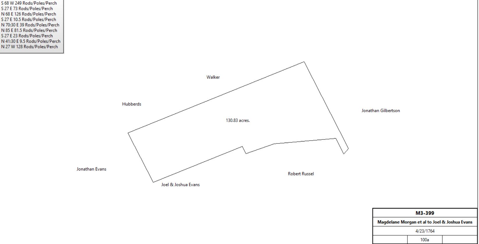
Magdelane Morgan et al |
Joel & Joshua Evans |
4/23/1764 |
100a |
£160 |
M3-399; neighbors: Walker, Hubberd, Jonathan Evans, Robert Russell, Jonathan Gilbertson. |
|
Joel Evans |
|
1778 |
100a |
|
Tax Freeman |
Joel Evans |
|
1779 |
100a |
|
Tax |
Richard Robinson |
|
1781 |
200a |
|
Tax. tavern |
Joel Evans |
|
1781 |
100a |
|
Tax |
Richard Robinson |
|
1783 |
200a |
|
Tax. tavern |
Joel Evans |
|
1783 |
100a |
|
Tax |
Richard Robinson |
|
1785 |
200a |
|
Tax. |
Joel Evans |
|
1786 |
100a |
|
Tax |
Richard Robinson |
|
1786 |
200a |
|
Tax. tavern |
Richard Robinson |
|
1787 |
200a |
|
Tax. tavern |
Richard Robinson |
|
1788 |
200a |
|
Tax. tavern |
Joel Evans |
|
1788 |
100a |
|
Tax |
Joel Evans |
|
1789 |
100a |
|
Tax |
Joel Evans |
|
1795 |
100a |
|
Tax |
Joel Evans |
|
1795 |
100a |
|
Tax. tanyard |
Joel Evans |
|
1797 |
100a |
|
Tax. tanyard |
Joel Evans |
|
1798 |
259a |
|
Glass tax, tenant Richard Robinson |
Joel Evans |
|
1798 |
100a |
|
Tax |
Richard Robinson |
|
1798 |
200a |
|
tax |
Joel Evans |
|
1799 |
270a |
|
Tax. tenant Richard Robinson, inn keeper |
Joel Evans |
|
1799 |
1000a |
|
Tax. Tanyard |
Joel Evans |
Randall Evans (nephew) |
2/5/1811 (proved) |
½ of 100a + 20a |
|
Will dated 9/16/1809 Will L-367 |
Joel Evans |
Joshua Evans junior (nephew) |
2/5/1811 |
200a (Paoli tract) |
|
Will dated 9/16/1809 Will L-367 |
Joshua Evans senior |
Joshua Evans junior |
1817 (will probated |
½ of 100a |
|
Will |
Randall Evans |
Thomas J. Walker |
6/20/1820 |
|
|
G3-199; agreement on disputed boundary. |
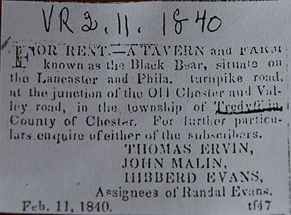
Randall Evans |
Thomas Irwin, John Malin, Hibbert Evans |
9/21/1839 |
|
|
Misc. Deeds p. 306
Assignment of trust |
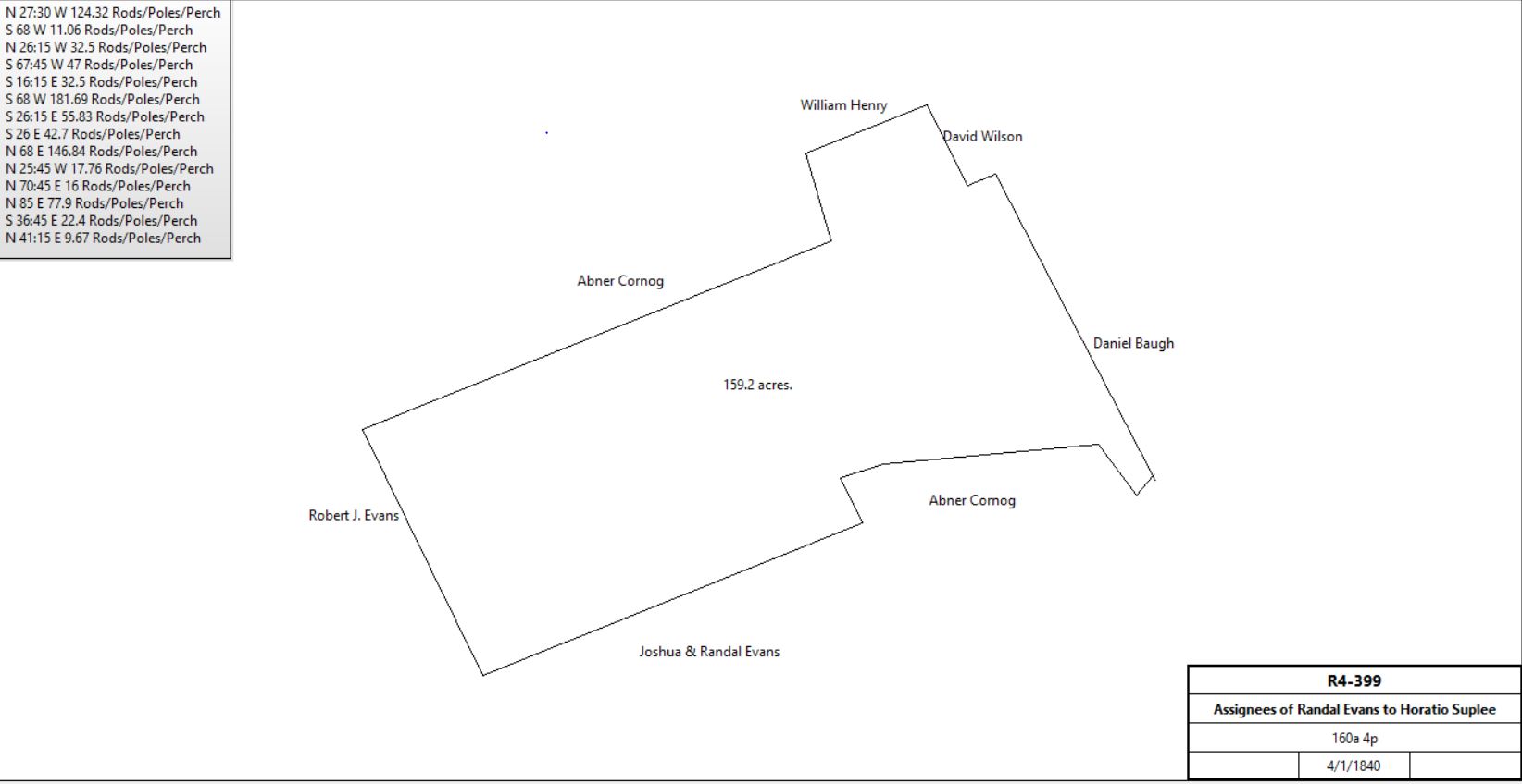
Thomas Irwin, John Malin, Hibbert Evans |
Horatio J. Suplee |
4/1/1840 |
160a 4p |
$12,441 94c |
R4-399; see table V.3 |
|
Joshua Evans |
John D. Evans (son) |
Abt. 1846 |
All real estate |
|
Will dated 6/12/1846. Will T-141 |
John D. Evans |
Caleb J. Duxbury |
12/21/1881 |
329a |
|
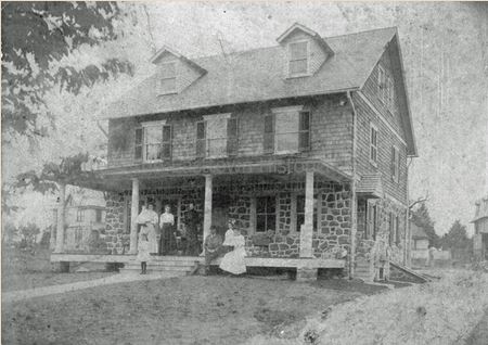
L9-401. 4 tracts; 2 in Tredyffrin (above and part of Pennington tract). The Evans farm is mentioned in biography of James Hervey Dewees in the article Promoters of Paoli |
Caleb J. & Helen A. Duxbury |
David B. Hedley, Samuel R. Shipley, John M. Kennedy |
12/21/1881 |
329a |
|
L9-404 |
David B. & Anna Hedley, Samuel R. & Anna Shipley, John M. & Marie del Carmen Kennedy |
Paoli Heights Land Co. |
12/22/1881 |
329a |
$25,000 |
L9-408 |
Paoli Heights Land Co. |
|
1883 |
|
|
Breou’s Atlas |
Paoli Heights Land Co. |
John H. Dingee |
8/5/1882 |
10.94a |
$6,564 |
Q9-309; see table v.12 |
Paoli Heights Land Co. |
John Craig of Philadelphia |
4/5/1883 |
13.31a |
$5,863 50c |
S9-78; Tredyffrin - see table v.4 |
Paoli Heights Land Company |
J. Hervey & Emma J. Dewees and Edward Bracken |
1/9/1899 |
0.368a |
$736 |
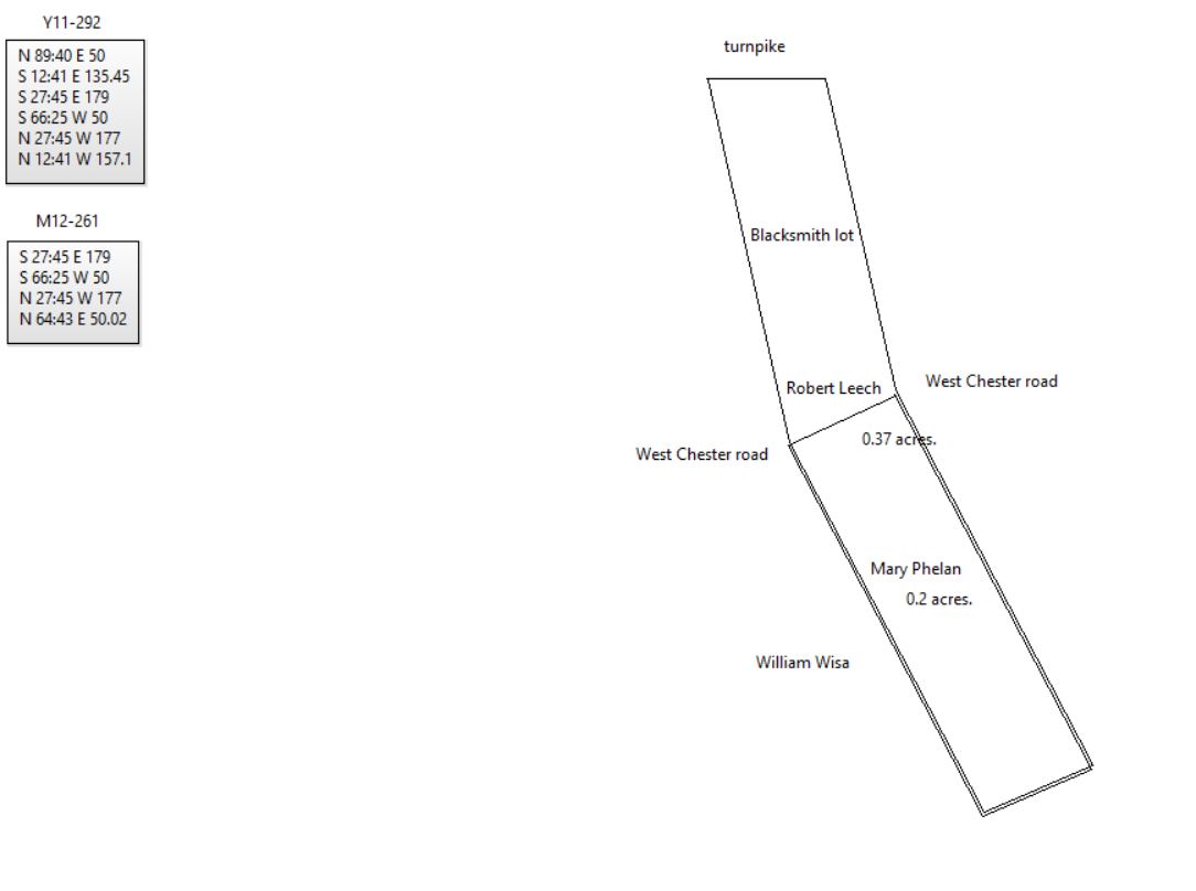
Y11-292; see table v.2 |
|
|
A-244 Deed. On 12 Sep 1699 Thomas Hort, son & heir of John Hort, late of the City of Bristoll in Old England, dec., & Samuel Atkins of Philadelphia, glover, & William Hearn of Philadelphia, blacksmith, to John Worral of Chester County, yeoman, & Phillip Yarnall of Chester County, yeoman. Whereas there is a tract bounded by land of Anthony Burgis, James Stanfield, land of Claypoole and Wood & Shadlow, containing 1000 acres granted to John Hort by William Penn dated 20 Apr 1685. Whereas John Hort died & the land descended to Thomas Hort, his son & heir & Thomas Hort did grant but not sufficiently convey the said land to Samuel Atkins & William Hearn. Now Thomas Hort, Samuel Atkins & William Hearn for £60 grant to John Worral & Phillip Yarnall the 1000 acres. Signed Thomas Hort, Samuel Atkins & William Hearn. Delivered in the presence of John Child, Henry Hollingsworth, Aulius Hoskins & George Oldfield. Recorded 13 Dec 1699.
L9-386 Easttown & Tredyffrin?
Beginning at a corner marked poplar tree, being also a corner of William Powell’s land, thence a line of marked trees SSE 250 perches to a post, thence by a line of marked trees ENE 314 5/12 perches to a post, being a corner of Mordecay Moor, thence by a line of marked trees, and the said land NNW 250p to a post, thence by another line of marked trees WSW 314 5/12 perches to the place of beginning.
|
Table V.1 Pennington tract
|
From |
To |
Date |
Area |
Cost |
Reference |
|
|
|
|
|
|
Joshua Evans (son of William Evans sr.) |
Robert Russell |
5/6/1763 |
224a 32p |
|
Q-145 description same as Q-148 |
Robert Russell |
Joshua Evans |
5/6/1763 |
224+a |
|
N-144 Mortgage |
Robert & Hannah Russell |
Thomas Pennington jr. |
3/21/1768 |
224a 32p |
|
Q-148 |
Thomas Pennington ux |
Buckridge Sims |
1769 |
224a 32p |
£200 |
Q-151 Mortgage cleared 2/11/1882 |
Thomas Pennington |
Joshua Evans |
3/1/1770 |
? |
£200 |
L9-369 lease |
Thomas Pennington |
Frederick Landis |
3/11/1795 |
|
10s per annum |
N2-216; use of ditch. See Mordecai Moore Patent for land purchases |
Thomas Pennington |
Thomas Pennington (son) and Hannah Parker (daughter) |
8/12/1796 |
|
|
Will |
Thomas & Judith Pennington |
John Parker |
4/1/1797 |
68a 70p + 12a |
|
R2-297;see deed plan |
John & Hannah Parker |
Thomas Pennington jr. |
4/1/1797 |
143a 120p |
5s |
R2-292 partition; see deed plan |
Thomas Pennington |
|
1798 |
149a |
|
Glass Tax |
John Parker |
|
1798 |
81a |
|
Glass Tax |
John Parker |
|
1797 - 1806 |
|
|
Licensee of the Bear on the turnpike |
Thomas Pennington |
Frederick Landis |
1/23/1802 |
6a 50p |
£71 3d |
V2-198 |
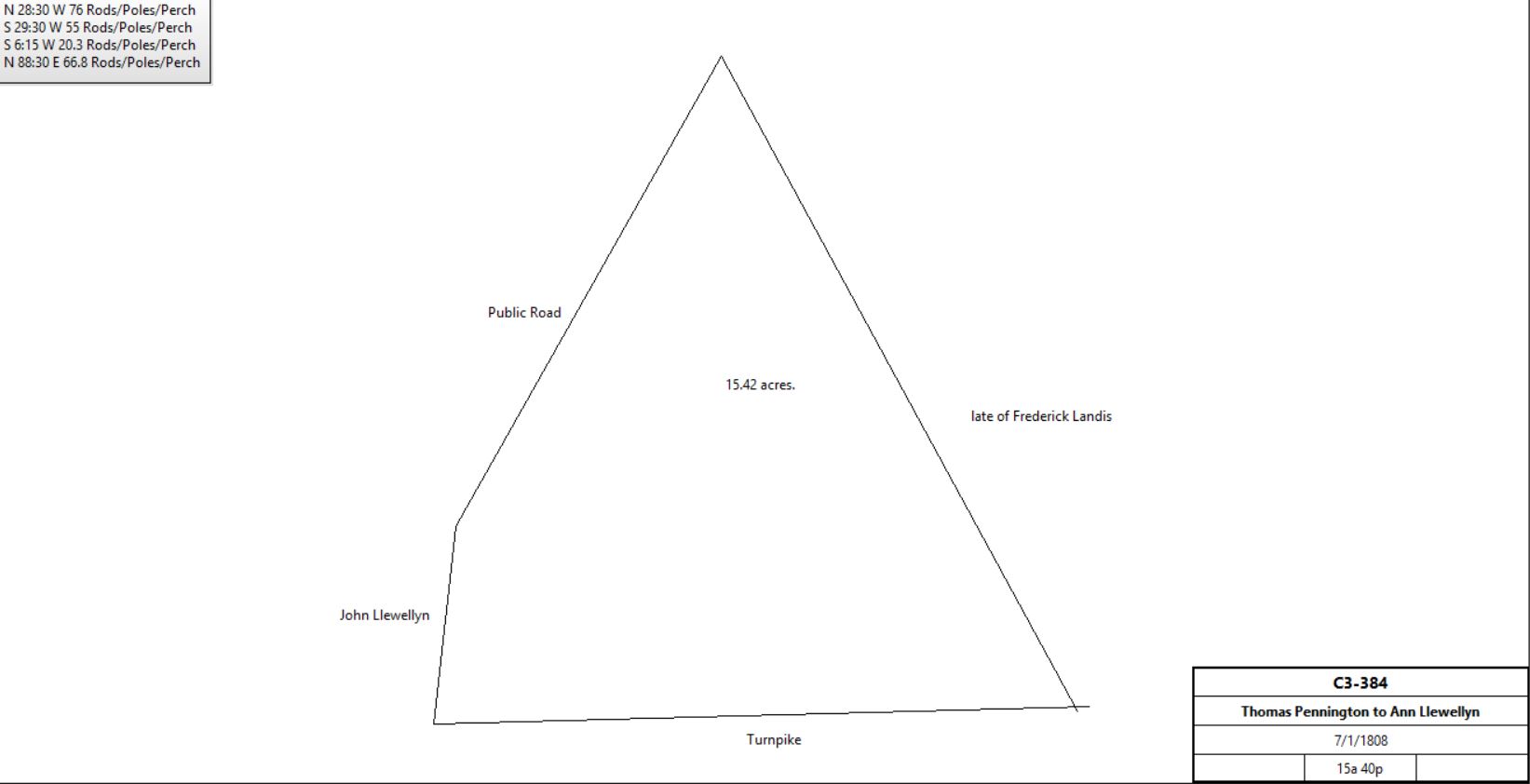
Thomas Pennington |
Ann Llewellyn |
7/1/1808 |
15a 40p |
$915 |
C3-384; see table AN.3 - part of Broomall tract in 1883 |
|
Joshua Evans sr. |
Joshua Evans jr. |
11/12/1815 |
|
|
L9-391 Assignment of lease |
Thomas Pennington jr. |
James Pennington (son) |
~1822 |
|
|
Will |
James Pennington |
Mary (widow), Thomas (son) and Sarah Ann Dickson (daughter) |
~1830 |
|
|
Died |
Ezekial Bowen, John & Hannah Clift |
Mary, Thomas and Sarah Ann Pennington |
3/23/1849 |
|
$56 53c |
L9-391 Release; Ezekial and Hannah children of Ruth Bowen |
Esther Bowen, adm. of William Bowen |
Mary, Thomas and Sarah Ann Pennington |
6/27/1849 |
|
$56 53c |
L9-392 Release; William son of Ruth Bowen |
Deborah Hannah |
Mary, Thomas and Sarah Ann Pennington |
|
|
$56 53c |
L9-393 Release; Deborah, daughter of Ruth Bowen |
Hezekial & Mary Wood |
Mary, Thomas and Sarah Ann Pennington |
9/28/1850 |
|
$56 53c |
L9-394 Release; Mary, daughter of Ruth Bowen |
Mary, Thomas, and Sarah Ann Dickson |
John D. Evans |
6/16/1866 |
75a 107p (part of 143a 120p) |
$5000 |
L9-394 Deed |
|
|
|
|
|
|
South of the Turnpike |
|
|
|
|
|
|
John Parker |
|
1798 |
81a |
|
Glass Tax |
John Parker |
|
1797 - 1806 |
|
|
Licensee of the Black Bear on the turnpike |
John Parker |
Hannah Parker |
1807 |
|
|
Died; administration |
Hannah Parker |
|
1807-9 |
|
|
Licensee of the Black Bear |
James & Hannah Foot |
Randel Evans |
1/15/1818 |
41a 135p & 5a |
$3630 39c |
O3-508 |
Ruth (nee Pennington) & John Bowen |
Randel Evans |
1/15/1818 |
|
5s |
O3-507; release |
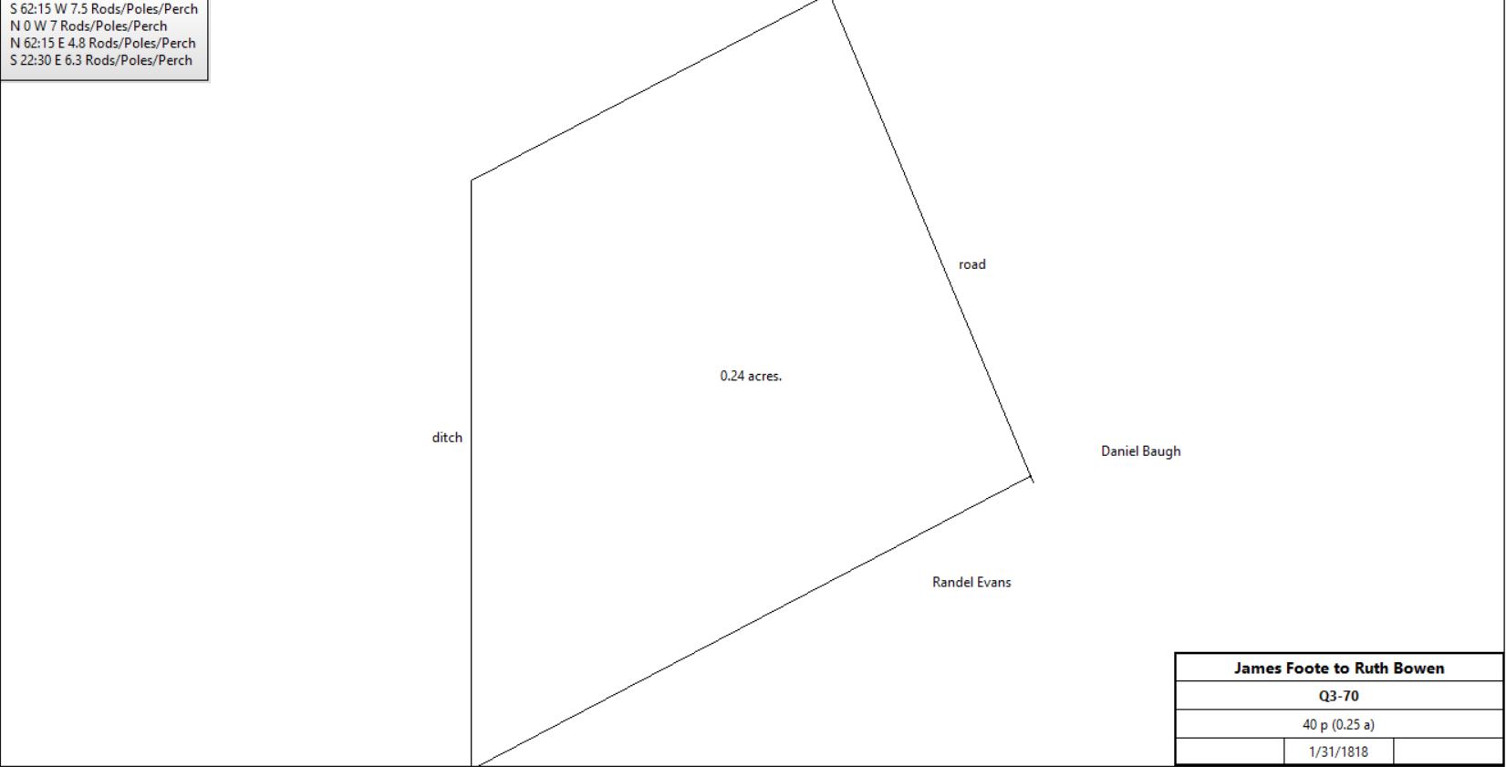
James & Hannah Foot |
Ruth Bowen |
1/31/1818 |
40 p (¼a) |
$32 |
Q3-70 |
|
|
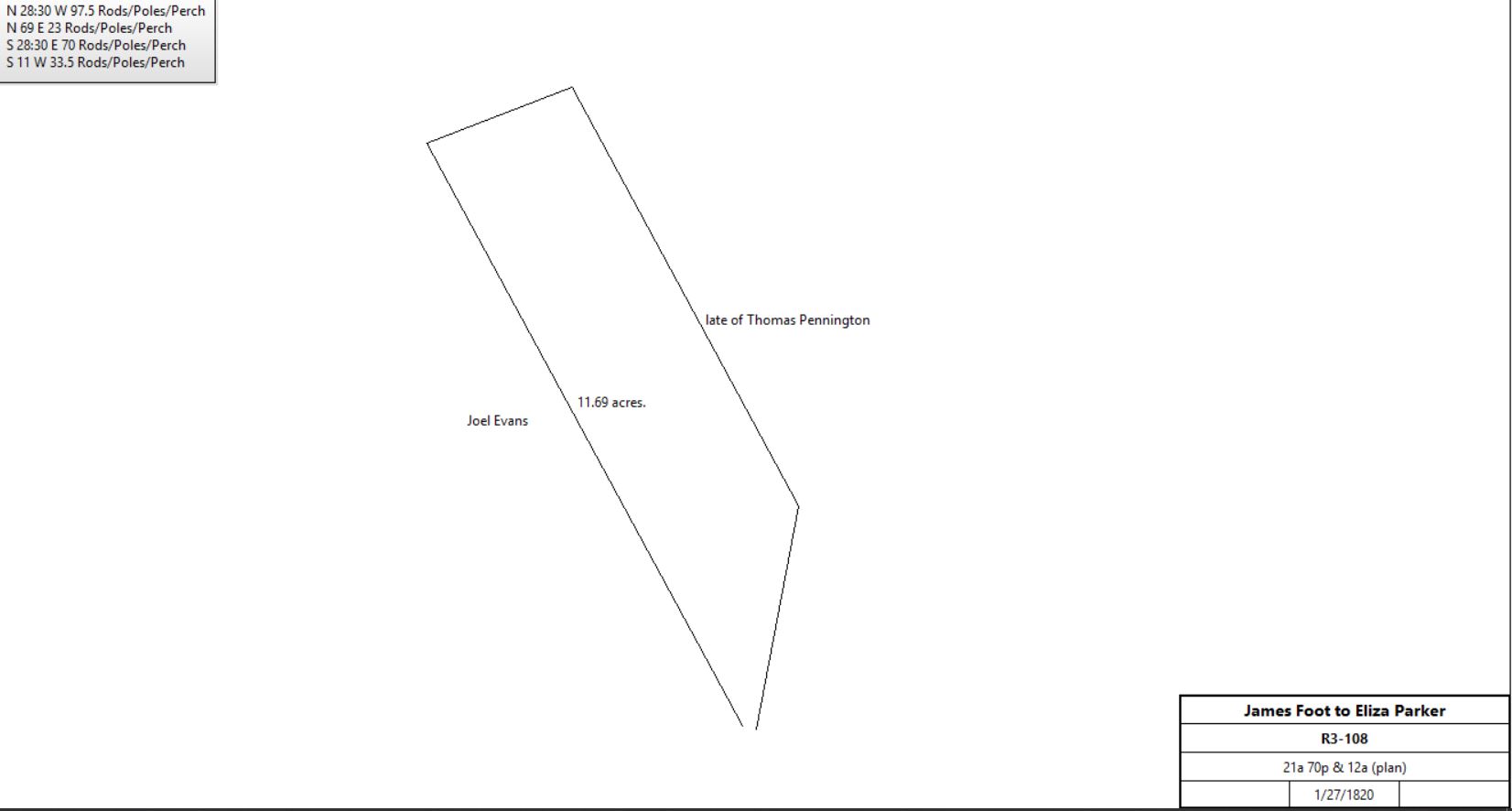
James & Hannah Foot |
Eliza Parker |
1/27/1820 |
21a 70p & 12a |
$200 |
R3-108; Black Bear tavern |
|
Randel Evans |
Josiah Garrett |
4/3/1828 |
70.5p, 3a, 41a 135p, 5a, 21a, & 12a |
$4,000; |
Mortgage Book P-232 |
|
|
|
|
|
Sheriff (David Bishop), debt of Randel Evans |
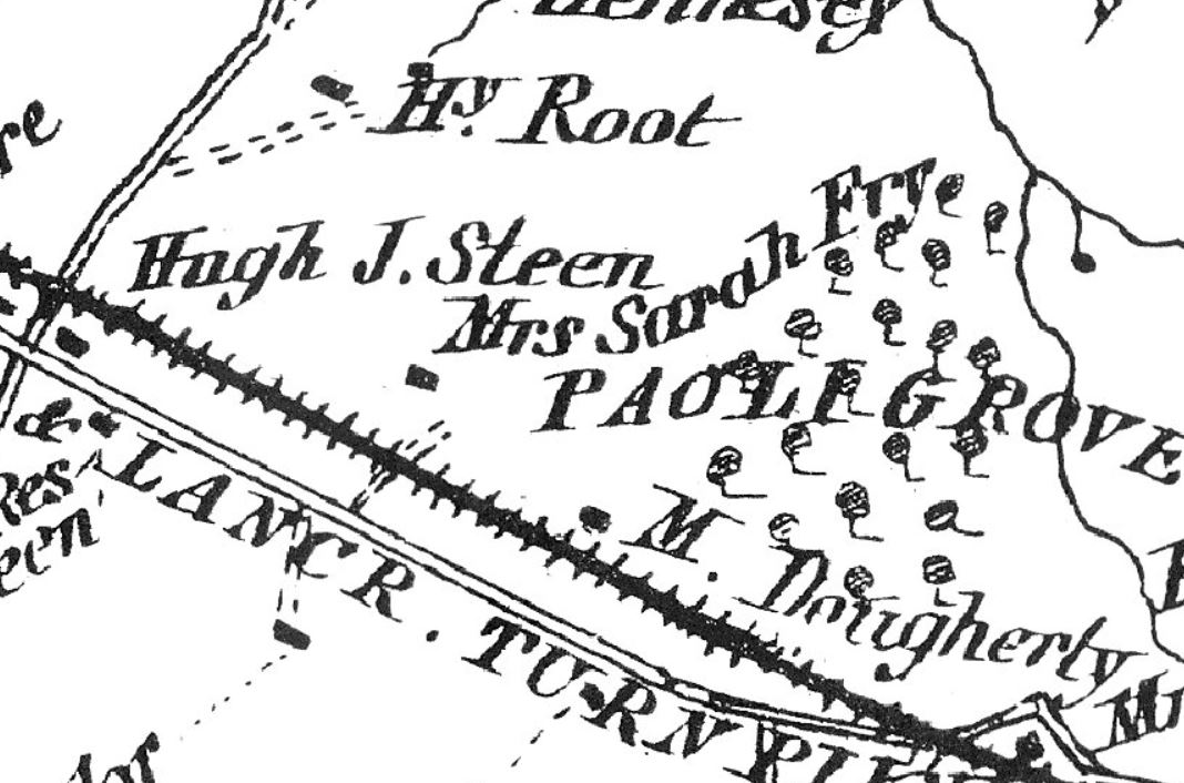
Hugh J. Steen |
1/30/1851 |
Lot #2 (54a 107p), Lot #3 (0.5a) |
$4,200 (lot #2) plus $310 (lot #3) |
P5-391 (including Bear Inn) |
John Walton |
Hugh J. Steen |
12/28/1864 |
14a 102p |
$1171 |
X6-374; Easttown adjacent to other land of Steen |
|
Hugh J. Steen |
1883 |
54a 2r 27p |
|
Breou; Tredyffrin & Easttown |
Thomas Butler, Executor of Hugh Steen |
J.H. Dingee |
2/14/1902 |
54a 2r 27p & 14a 102p |
|
G12-527 |
part of Tredyffrin Country Club |
|
1930 |
|
|
Atlas |
Joseph R. & Marion C. Culhane, Jnaie-Belle S. & W. Foxall Macelree |
Tredyffrin Construction Company |
6/8/1948 |
|
|
H22-500 |
|
|
N-144 On 6 May 1763 Robert Russell of Tredyffrin, yeoman to Joshua Evans of Tredyffrin. Robert Russell stands bound to Joshua Evans for £200 conditioned on the payment of £100 plus interest on the 27 Nov 1765. Robert Russell to better secure said debt granted to Joshua Evans a tract of land in Tredyffrin bounded by land of Michael Wayne, Jonathan Gilbert, Joshua Evans & Joel Evans containing 244 acres. Signed Robert Russell. Delivered in presence of Samuel havard and Lewis Reece. Recorded 27 Sept 1763.
Q-148 Beginning at a stone for a corner in Michael Wayne’s land, thence N26¾°W by said land and land of Jonathan Gilbert 261 5/12 perches to a chestnut oak, thence S41½°W by other land of Joshua Evans 9½ perches to a black oak, thence N26¾°W by last mentioned land 23 perches to a chestnut, thence S85°W 81½ perches by said land to a hickory sapling, thence S70½°W by said land 39 perches to a chestnut oak for a corner in the line of Joel Evan’s land, thence S27¼°E by last mentioned land 97½ perches to a stone for a corner in the last mentioned land, thence east by said land 26½ perches to a small chestnut sapling for another corner in Joel Evan’s land, thence S10½°E by last mentioned land 82½ perches to a hickory in said Evans land, thence S27¼°E 58½ perches to a black oak sapling, thence S22½°E by said land 67½ perches to a stone, a corner in the line of Michael Wayne’s land, thence N53¼°E (changed to 63¼ to close loop ) by last mentioned land 129 perches to the place of beginning.
L9-389 Plot of land 2 perches wide beginning SW corner of his plantation thence along Michael Wayne’s line N63¼°E until it extends 2 perches over the natural channel of the stream that descends from Thomas Pennington’s house to Wayne’s meadows.
L9-394 Beginning at a stake in the middle of the Lancaster turnpike, thence by land of Holland G. Malin N4½°W 29.36 perches to a large chestnut tree, and S80½°E 31.8 perches to a mulberry tree, thence by land of William P. Hamm and along a public road N32½°E 20.6 perches to a stake, thence along the middle of said road N6½°E 46.5 perches to a stake, thence by land of Samuel McKeever N25°W 26.4 perches, and N79½°E 11.25 perches to a post in the line of James C. Baugh’s land, thence by said Baugh’s land N26½°W 29 perches to a marked slate and flint stone, thence by land of Clement Biddle N84¼°W 70.5 perches to a limestone, and S41°W 35 perches to a limestone, and S71°W 9.44 perches to a stake, thence by land of William W. Davis S15½°W 35.33 perches to a limestone, thence by land of John D. Evans, party hereto, S89¼°E 27 perches and S9°E 81 perches to a corner of land late of John Eavonson, thence by said land S27¾°E 5.8 perches, and South 1.82 perches to the middle of the Lancaster turnpike, thence by same S89¾°E 35.2 perches to the place of beginning.
|
Table V.1.1 – Malin/Schofield Store
|
From |
To |
Date |
Area |
Cost |
Reference |
|
|
|
|
|
|
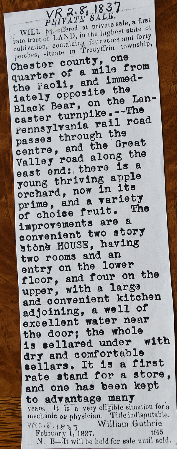
Thomas Pennington |
William Guthrie |
2/3/1817 |
3¼a |
$455 |
M3-380; messuage |
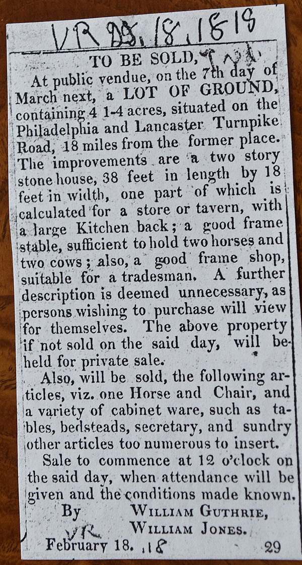
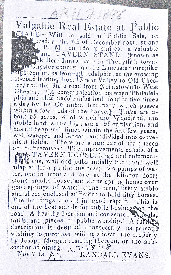
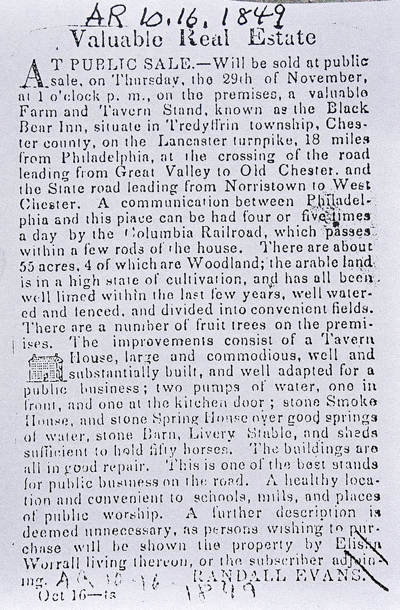
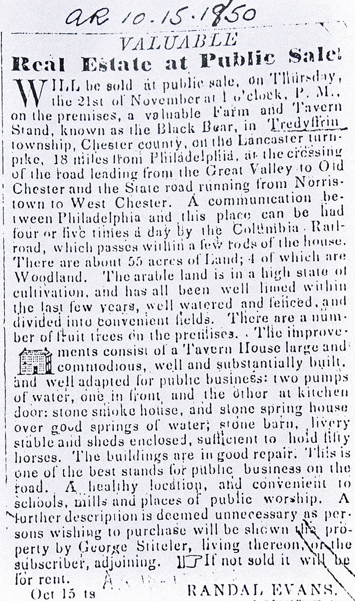
See Newspaper clipping in Document database for commentary |
|
William Guthrie |
Elizabeth Kaiser, daughter |
1835? |
|
|
Will |
Adam & Elizabeth (nee Guthrie) Kaiser |
Isaiah Worrell |
1839 |
|
|
R4-592 |
Isaiah Worrell |
Holland G. Malin |
4/2/1840 |
1a + 3¼a + 2a 38p |
$1,000 |
T4-275 |
Holland G. Malin |
Alice Worrell |
9/28/1843 |
2a 38p |
|
Y4-271 |
Hollon Malin |
|
1847 |
|
|
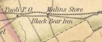
Malin’s store, Chester County map |
|
Hollon Malin |
Henry Schofield |
3/18/1867 |
1a & 3¼a |
$8,000 |
C7-485 |
Harry & Helen Schofield |
Emily Dingee |
6/8/1887 |
2.876a |
$3,000 |
I10-50; see table v.12 for later history |
Harry & Helen Schofield |
John Dingee |
5/13/1912 |
0.938a |
$1 |
E14-455 |
|
|
|
|
|
|
Alice Worrell |
Thomas Hall |
4/12/1858 |
2a 38p |
$550 |
H6-417 |
Thomas & Jane Hall of Tredyffrin |
Cormick Gallagher |
5/5/1864 |
2a 38p |
$850 |
X6-92 |
|
Table V.2 – Paoli Pike
|
From |
To |
Date |
Area |
Cost |
Reference |
|
|
|
|
|
|
|
|
|
|
|
|
Paoli Heights Land Company |
J. Hervey & Emma J. Dewees and Edward Bracken |
1/9/1899 |
0.368a |
$736 |
Y11-292; lot only |
J. Hervey & Emma J. Dewees and Edward Bracken |
Mary J. Phelan |
3/31/1902 |
0.231a |
$3,200 |
M12-261; double house and lot |
|
Mary J. Phelan |
Thomas Phelan, husband |
2/16/1910 |
|
|
died |
Thomas Phelan |
William & Rita T. McCully |
1/9/1923 |
0.1a |
$4,000 |
E16-267 |
William & Rita T. McCully |
Clarence G. & Anna S. Hoag |
11/18/1926 |
0.1a |
$4,500 |
D17-425 |
Clarence G. & Anna S. Hoag |
John & Mary A. McCann |
9/18/1931 |
0.1a |
$3,500 |
O18-551 |
John McCann |
Walter R. Farra |
5/7/1942 |
0.1a |
$2,500 |
X20-420 |
Walter R. Farra, deceased |
Lawrence W. & Ruth B. Farra |
3/26/1965 |
0.1a |
$4,666 67c to estate |
G36-821; died, Orphan's Court order |
Lawrence W. & Ruth B. Farra |
Lawrence W. & Ruth B. Farra |
3/31/1968 |
0.1a |
$1 |
H36-83 |
Lawrence W. & Ruth B. Farra |
William Cuthbertson |
6/7/1978 |
0.1a |
$14,500 |
M39-894 |
|
Table V.3 – Airdrie
|
From |
To |
Date |
Area |
Cost |
Reference |
|
|
|
|
|
|
Joel Evans |
|
1798 |
99a |
|
Glass tax Also see table V |
Joel Evans |
|
9/16/1809 |
|
|
Will proved 2/5/1811 |
Joshua Evans |
|
11/18/1815 |
|
|
Will proved 5/6/1817 |
Randall Evans |
Thomas Ervine, John Malin, Hibberd Evans |
9/21/1839 |
|
|
Misc. 306 or 506. Trust. |
Thomas Ervine, John Malin, Hibberd Evans |
Horatio Supplee |
4/1/1840 |
160a 4p |
$12,441 94c |
R4-399 |
Horatio Supplee |
Edmund C. Evans |
11/14/1843 |
160a 124p |
$12,862 |
Y4-286 |
|
Edmund C. Evans |
Thomas Biddle |
12/11/1850 |
160a 124p |
$9,338 |
M5-444 |
|
John Beaver, admin. of James H. Pennington |
Abner Cornog |
2/12/1833 |
16a 93p |
$450 83c |
L4-77; Messuage and woodlot, north end of Pennington’s 97a. See table V.1 |
Executors of Abner Cornog |
Thomas Biddle |
3/19/1857 |
16a 93p |
$414 53c |
F6-157; woodland |
Hannah Henry et al (heirs of William Henry) |
Joseph McClure |
4/1/1854 |
4a 3r 8p |
$900 |
W5-258; see table B.1 |
Joseph & Mary McClure |
Thomas Biddle |
3/17/1857 |
4a 3r 8p |
$950 |
E6-18; messuage and tract |
|
Executors of Christine Biddle (Thomas A. & Alexander Biddle) |
Clement Biddle |
3/8/1864 |
5 tracts |
|
V6-517 |
Lewis D. Cornog et ux |
Clement Biddle |
3/29/1865 |
Tract of woodland |
|
Y6-615 |
Clement Biddle |
|
3/16/1879 |
|
|
Died |
Thomas A. & Julia, Alexander & Julia, Lydia U., & Spencer Fullerton Baird Biddle, Richard U. & Christine Biddle Cadwalader,Thomas Biddle, Emily Williams Biddle |
Moncure Robinson & Samuel Baird |
4/13/1880 |
6 tracts. #1 160a 124p; #2 4a 3r 8p; #3 16a 93p; #4 1.5a; #5 5a 30p; #6 10a 65p |
$25,000 |
G9-418a |
Moncure & Charlotte Robinson & Samuel Baird |
Moncure Robinson jr. & Lydia M. Biddle |
4/17/1880 |
6 tracts |
$25,000 |
G9-425a |
Moncure Robinson est. |
|
1897 |
250a |
|
Atlas |
Lydia M. Robinson |
|
1912 |
250a |
|
Atlas |
Lydia M. Robinson |
|
1926 |
199a |
|
Atlas |
|
|
G9-418 #1 Beginning at a stone in the line of land formerly owned by Daniel Baugh deceased, thence by the same N27½°W 124.3p to a stone a corner of David Wilson’s land, thence by the said Wilson’s land S70¼°W 11.08p, thence by the same N26¼°W 22.4p to a corner of land formerly of William Henry, late of Clement Biddle deceased hereinafter described, thence by said land S68°W 47p to a corner of land formerly of Abner Cornog now of _ , thence by the same land S16¼°E 32.4p, thence by the same S68°W 181.7p to a corner in the line of land formerly of Robert J. Evans deceased, thence by the same S26½°E 42.7p to a stake, thence by land formerly of Joshua and Randall Evans and now in part of John D. Evans N68°E 146.84p to a corner in the line of land formerly of Robert Clemmings deceased since of Christine Biddle and late of Clement Biddle deceased hereinafter described, thence N26¼°W 14.8p to a stone, thence N70¾°E 16p to a stone, thence by the same N85°E 78p by land belonging to the estate of James Pennington and since in part of Christine Biddle and late of Clement Biddle deceased hereinafter described, thence S36¼°E 22.45p to a Black Oak, thence by the same along the line of land late of Clement Biddle deceased hereinafter described N41½°E (?) 9.67p to the place of beginning.
#2 Messuage & tract beginning at a stone, a corner of David Wilson’s land, thence by land formerly of Abner Cornog deceased S68½°W 19.16p passing through a Black Oak tree to a corner of a lot of land formerly belonging to the Philadelphia & Lancaster Roade Company since of the estate of Christine Biddle and late of Clement Biddle deceased hereinafter described, thence by the same the 2 following courses and distances S22°E 9.9p, S68½°W 25p, thence by land formerly of Abner Cornog deceased S15½°E 12.4p, thence by said first mentioned farm, plantation, or tract of land N68¾°W 22.5p to the place of beginning.
#3 Woodland beginning at a stake in the land formerly of Daniel Baugh deceased, it being a corner of land formerly owned by Randall Evans deceased since of said Christine Biddle and late of Clement Biddle deceased hereinafter described, thence by the same S40½°W 9.7p to a corner Black oak tree, thence by the same N37°W 22.6p to a corner Chestnut tree, thence by the same S84¼°W 8p to a limestone, it being a corner of land now or late of Peter Jaquett, thence by the same S23°E 40.5p to a limestone, another corner of the same, thence S84¼°E 70.8p to a corner stake in the west edge of a flint and slate stone road, in the line formerly of Daniel Baugh deceased, thence by the same N27¼°W 41.2p to the place of beginning.
#4 Beginning at a corner of land formerly of John Henry afterwards of Joseph McClure uncle of Christine Biddle and late of Clement Biddle deceased in the line of land formerly of Enos Reese and late of the estate of Abner Cornog deceased at the end of the public road or lane 20 feet wide which road or lane leads westward from said lot to a public road leading from the Swedesford to Paoli tavern, thence by land formerly of John Henry and late of Clement Biddle N66°E 24p to a post and thence by other land formerly of William henry deceased since of Christine Biddle and late of said Clement Biddle deceased S74°E 9.9p to a post and S66°W about 25p passing a marked white oak to lands formerly of Enos Rees aforesaid and late of Abner Cornog deceased thence by said line N17½°W 10p to the place of beginning.
#5 Woodland beginning at a stone in the line of James Foote’s land, thence by the same N24°W 37.6p to a marked Chestnut tree and by the same N27¾°W 28.4p to a stone in the line of land formerly of Randall Evans deceased and since of Christine Biddle and being in the southern line of the first mentioned farm or plantation, thence by the same N69 14.2p to a stone, thence by land of Thomas Pennington S24°E 66p to a stone, by the same land S69¼°W 12.2p to the place of beginning.
#6 Woodland beginning at a flint stone, a corner of land formerly of Robert Clemens deceased and late of said Clement Biddle, and in the line of land formerly of Randall Evans also late of Clement Biddle, thence by the same N68½°E 1.8p to a corner limestone, and N84°E 30.3p to a limestone, thence by land late of James Pennington deceased S23°E 40.6p to a limestone and S39°W 35.5p to a limestone being a corner of Robert Clemens land, late of said Clement Biddle, thence by the same N23°W 65.9p to the place of beginning.
|
Table V.4 – Craig property
|
From |
To |
Date |
Area |
Cost |
Reference |
|
|
|
|
|
|
Paoli Heights Land Co. |
John Craig of Philadelphia |
4/5/1883 |
13.31a |
$5,863 50c |
S9-78; Tredyffrin |
Richard Graham |
John Craig |
3/6/1884 |
17a |
$1,350 |
T9-420; Easttown |
Mrs John Craig |
|
1887 |
3.018a |
|
Atlas |
Estate of John Craig |
|
1900 |
15a |
|
Atlas |
Thomas Janney, guardian of Catherine Craig |
John H. Dingee |
6/13/1910 |
Majority of the lots of Craig tract |
|
Z13-156; lots 16,17,19, 20, 21, 25 - 32, 40, 49 - 56 |
William Russell |
John H. Dingee |
6/19/1910 |
|
|
U13-461 |
John H. & Helen Dingee, George & Sara Wilson, Warren DeLong |
John Graham |
11/25/1910 |
|
$7,500 |
Z13-396; lots 24 - 32 |
John H. & Helen Dingee |
John Wirgman |
12/19/1910 |
|
$5 and other considerations |
Z13-443; lots 16,17,19,20,21 |
J. L. Smith Railroad Atlas, Overbrook to Malvern, 1900
|
|
Table V.5 – Foulke development
|
From |
To |
Date |
Area |
Cost |
Reference |
|
|
|
|
|
|
Charles & Sadie Foulke |
J. Roberts Foulke |
8/1/1882 |
8.62a |
$6,260 |
R9-331 |
Paoli Heights Land Co. |
J. Roberts Foulke |
2/21/1887 |
1.017a |
$896 20c |
D10-478 |
J. Roberts & Emma Foulke |
John Carson Eves |
8/28/1905 |
not quoted |
$600 |
Y12-6; no mention of house |
|
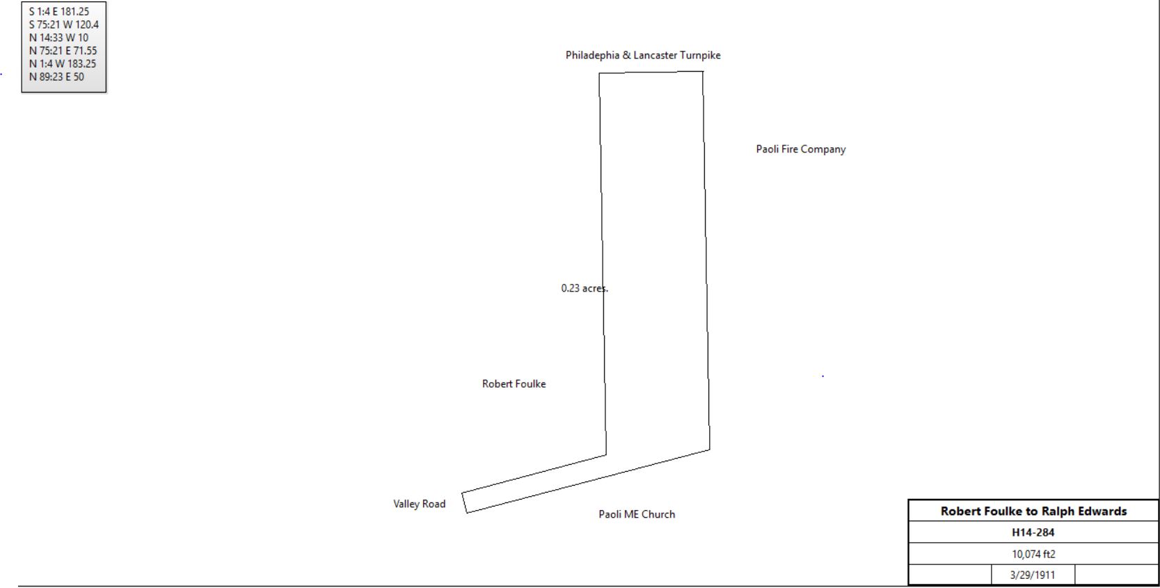
J. Roberts Foulke |
Ralph Edwards |
3/29/1911 |
10,074 ft2 |
$1,690 |
H14-284 |
|
|
Table V.6 – Paoli Water
|
From |
To |
Date |
Area |
Cost |
Reference |
|
|
|
|
|
|
Paoli Heights Land Co. |
Richard B. Tschudy |
3/11/1882 |
3.38a + 1.14a + 13.13a |
$16,732 27c |
Q9-186; including right to lay water pipes |
Richard B. Tschudy |
John M. Kennedy |
4/4/1882 |
3.38a + 1.14a + 13.13a |
$16,732 27c |
Q9-190 |
Paoli Heights Land Co. |
John M. Kennedy |
11/28/1882 |
0.76a |
$765 49c |
R9-328 |
John M. & Carnitade(?) Kennedy |
Samuel R. Shipley |
2/18/1885 |
3.38a + 1.14a + 0.76a |
$18,000 |
Z9-28; first tract is the Paoli Inn |
Samuel & Agnes Shipley |
Elizabeth Ancr |
5/22/1895 |
0.218a |
$15,000 |
M11-4 |
Samuel & Agnes Shipley |
Harry Lippincott |
1/20/1899 |
|
|
Quoted in Y11-315 |
Harry & Emma Lippincott |
John McCrea |
1/20/1899 |
3.38a + 0.78a + 0.739a + 1.14a + 0.76a - 0.218a |
$1 |
Y11-315 |
John McCrea |
J. Hervey and Emma Dewees & Edward Bracken |
2/8/1899 |
1.294a |
$3,000 |
V11-558 |
J. Hervey and Emma Dewees & Edward Bracken |
John Hanley |
10/10/1902 |
5,970 ft2 |
$330 |
O12-63 |
John McCrea |
Samuel Shipley |
9/20/1899 |
3.38a + 0.78a + 1.137a (all parts of Y11-315) |
$2,000 |
A12-1 |
Paoli Water Company |
S. R. Shipley |
5/15/1901 |
|
$100 |
I12-8; use of lane to turnpike |
|
Table V.7 –
|
From |
To |
Date |
Area |
Cost |
Reference |
|
|
|
|
|
|
Paoli Heights Land Co. |
Samuel R. Shipley |
9/12/1887 |
0.739a |
$517 30c |
H10-360 |
John McCrea |
J. Harvey Dewees & Edward F. Bracken |
2/8/1899 |
1.294a |
$3,000 |
V11-558 |
J. Harvey and Emma Dewees & Edward F. Bracken |
John J. Hanley |
8/1/1900 |
14,932.8 ft2 |
$3,100 |
A12-521 |
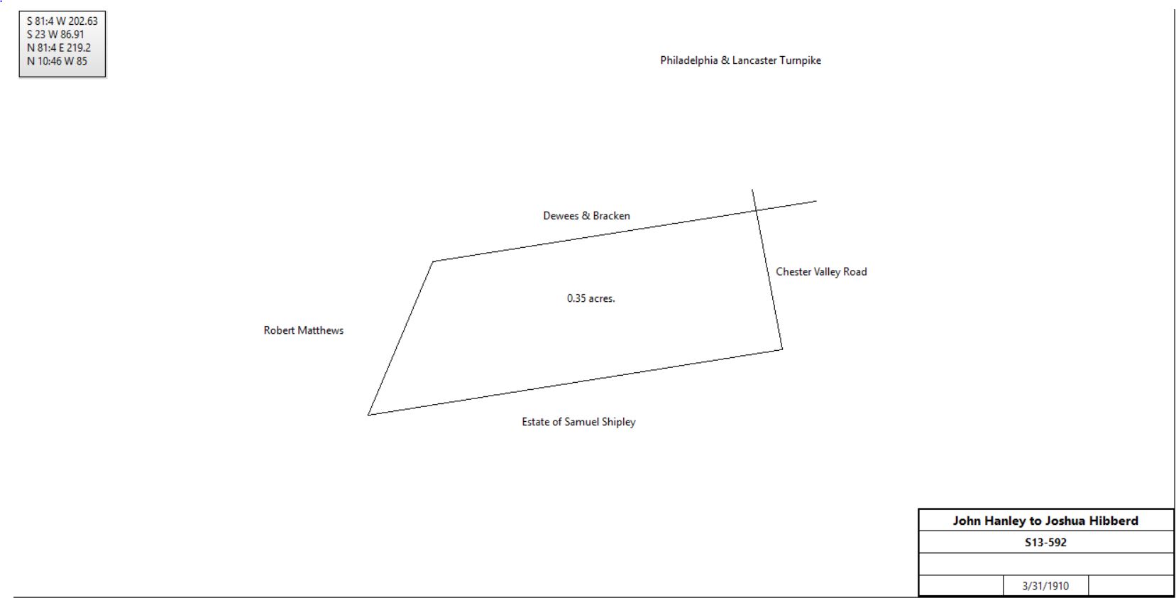
John J. Hanley |
Joshua Hibberd |
3/31/1910 |
|
$4,500 |
S13-592 |
|
|
Table V.8 – Paoli Railroad Station
|
From |
To |
Date |
Area |
Cost |
Reference |
|
|
|
|
|
|
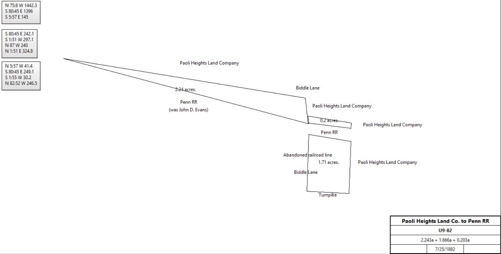
Paoli Heights Land Co. |
Pennsylvania Railroad Company |
7/25/1882 |
2.243a + 1.666a + 0.203a |
$1 + other considerations |
U9-82 |
|
|
Table V.9 – Addition to the Paoli Inn tract
|
From |
To |
Date |
Area |
Cost |
Reference |
|
|
|
|
|
|
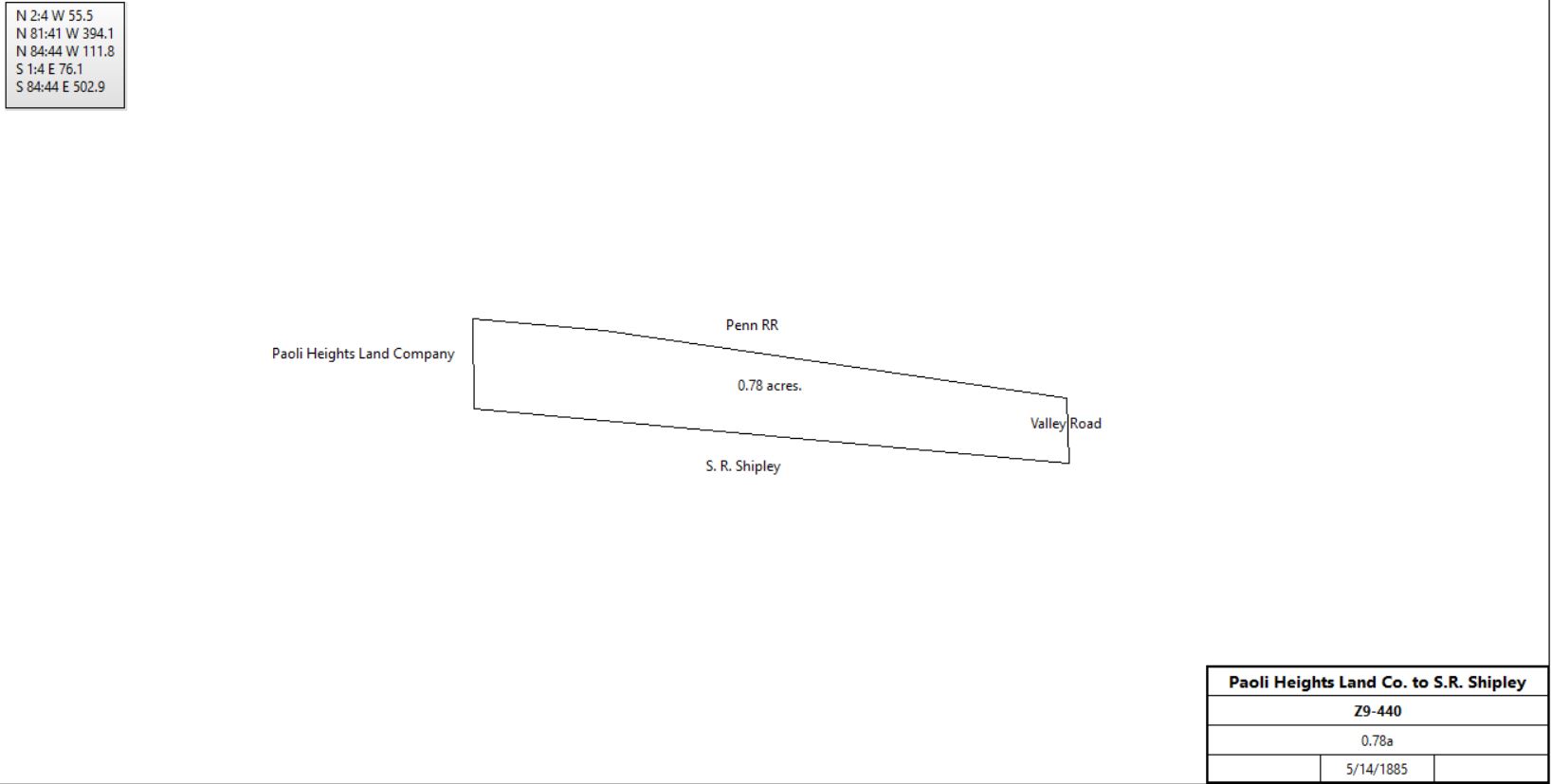
Paoli Heights Land Co. |
S. R. Shipley |
5/14/1885 |
0.78a |
$468 |
Z9-440; this seems to be the original railroad right of way. |
|
|
Table V.10
|
From |
To |
Date |
Area |
Cost |
Reference |
|
|
|
|
|
|
Paoli Heights Land Co. |
S. R. Shipley |
5/23/1900 |
1.928a + 1.629a + 3.855a + 12.357a |
$18,809 82c |
Z11-463 |
|
Samuel Shipley |
|
|
|
Purchases Outside Tredyffrin: C7-143, F7-231; K7-32; E11-279; P11-140; E12-153(all East Bradford); U9-492 (West Chester) |
|
Table V.11 - Frederick Landis / Lantis tract
|
From |
To |
Date |
Area |
Cost |
Reference |
|
|
|
|
|
|
Frederick Landis |
|
c. 1803 |
168a 49p |
|
died intestate |
Henry, Philip, Anna, & Jacob Landis, Magdelena Good |
Frederick Landis junior |
6/6/1803 |
61a 110p |
£555 10s 6d |
X2-22; Tredyffrin & Easttown |
Henry, Anna, Frederick, & Jacob Landis, Magdelena Good |
Philip Landis |
6/6/1803 |
90a 39p |
£1,386 5s 6d |
X2-24; Tredyffrin & Easttown |
Frederick Landis |
|
c. 1808 |
|
|
died intestate |
Philip Landis, administrator of the estate of Frederick Landis |
John G. Bull |
12/30/1811 |
20a 3r 8p |
$811 20p |
Q3-239 |
John G. Bull |
Samuel Wharton |
4/20/1839 |
22a 26p |
$950 |
Q4-678; Tredyffrin & Easttown; Q3-239 and 240 |
Table V.11.a |
Philip & Catharine Landis through their attorney, Joshua Evans |
William Lawrence |
10/8/1817 |
4a 94p |
$688 |
Q3-112 |
William Lawrence of Willistown |
|
1842 |
|
|
died |
Joshua Jones & Joseph Lawrence, executors of the will of William Lawrence |
Hollan Malin |
8/13/1844 |
2a 47p |
$166 30c |
B5-423 |
Hollam (store keeper) & Mary Ann Malin |
William A. Hayman |
8/16/1852 |
2a 47p |
$200 |
W6-425 |
Jonathan & Elizabeth Morris |
William A. Hayman |
11/26/1853 |
2a 47p |
$200 |
Y6-109 |
William A. & Elizabeth Hayman |
Nathaniel Lawrence |
4/2/1864 |
4a 94p |
$400 |
W6-421 |
Table V.11.b |
Philip & Catharine Landis of Easttown |
Joshua Evans & Nathan Pawling |
4/15/1816 |
4a 44p |
$1,026 |
C4-173; woodland in Tredyffrin |
Jesse Sharp, Sheriff, debt of Nathan Pawling |
Joshua Evans |
5/10/1825 |
4a 44p |
$30 25c |
C4-174 |
John D. Evans |
Samuel Brinkley Hayman |
2/27/1847 |
4a 44p |
$800 |
W6-357; Messuage |
Samuel Brinley Hayman |
Elizabeth Hayman |
|
|
|
deed not found; quoted in W6-423 |
Elizabeth Hayman |
|
|
|
|
died, Will book W(22)-91 |
William A. & Elizabeth Hayman, Charles & Mary Hayman, Maggie & Sallie Hayman, children of Elizabeth Hayman |
Nathaniel Lawrence |
4/2/1864 |
4a 44p |
$1,225 |
W6-423 |
Nathaniel & Jane Lawrence |
Edward Fry |
2/11/1869 |
8a 138p |
$2,775 |
U7-86 |

|
Mrs Fry |
|
1873 |
|
|
Witmer’s atlas |
Witmer's Atlas, 1873
|
|
Table V.12
|
From |
To |
Date |
Area |
Cost |
Reference |
|
|
|
|
|
|
Paoli Heights Land Co. |
John H. Dingee |
8/5/1882 |
10.94a |
$6,564 |
Q9-309 |
Paoli Heights Land Co. |
John H. Dingee |
4/19/1884 |
2.27a |
$2,043 |
Y9-391 |
Paoli Heights Land Co. |
John H. Dingee |
11/19/1885 |
9.894a |
$5,639 |
B10-108 |
John H. Dingee |
Emily Dingee |
2/15/1887 |
10.94a + 2.27a + 9.894a |
$1 |
D10-461 |
Harry & Helen Schofield |
Emily Dingee |
6/8/1887 |
2.876a |
$3,000 |
I10-50; see table v.1.1 for earlier history |
Edward & Mary Van Dyke, Elizabeth Burroughs, John H. & Helen Dingee |
Frederick Hubble |
2/12/1892 |
10.94a + 2.27a + 9.894a + 2.876a |
$1 |
A11-2 |
Frederick Hubble |
Helen Dingee |
2/12/1892 |
10.94a + 2.27a + 9.894a + 2.876a |
$1 |
A11-7 |
Helen & John H. Dingee |
The National Transit Co. |
6/9/1897 |
0.439a |
$1 |
U11-288 |
The National Transit Co. |
Griffith Callahan |
1/15/1898 |
0.291 |
$11,500 |
W11-122 |
|
Griffith & Ida Callahan, John & Helen Dingee, Henry & Jesse Biddle |
Pennsylvania Railroad |
4/29/1907 |
0.291a |
$500 |
Y12-250; land as a roadway |
|
Table V.13 - Coal Merchants
|
From |
To |
Date |
Area |
Cost |
Reference |
|
|
|
|
|
|
The Paoli Heights Land Company |
Joseph Gillam |
3/11/1882 |
8.71a |
$5,222 14c |
N9-570; part of L9-408 (see first section at top of the page) |
Joseph & Mary Gilliam |
David Headley |
1/25/1883 |
2.066a |
$3,000 |
R9-410 |
David & Anna Headley |
Isaac & Henry Hall |
1/31/1883 |
2.066a |
$3,000 |
R9-426 |
Isaac & Abigail Hall |
Henry Hall |
8/2/1883 |
½ part of 2.066a |
$2,500 |
O9-377 |
|
|
|
|
|
|
The Paoli Heights Land Company |
Henry Hall |
10/5/1883 |
1.667a |
$1,333 60c |
U9-292; part of L9-408 (see first section at top of the page) |
|
|
|
|
|
|
Henry & Ann Eliza Hall |
J. Hervey Dewees & Edward Bracken |
6/23/1898 |
2.2a |
$15,000 |
V11-335; parts of O9-377 and R9-426; and U9-292 |
J. Hervey and Emma Dewees, Edward and Lois Bracken |
Mildred Mateer |
12/19/1912 |
2.2a |
$1 |
H14-567 |
Mildred Mateer |
Edward Bracken |
12/19/1912 |
2.2a |
$1 |
H14-569 |
Edward & Lois Bracken |
Great Valley Mills |
4/13/1926 |
2.2a |
$1 |
E17-46 |
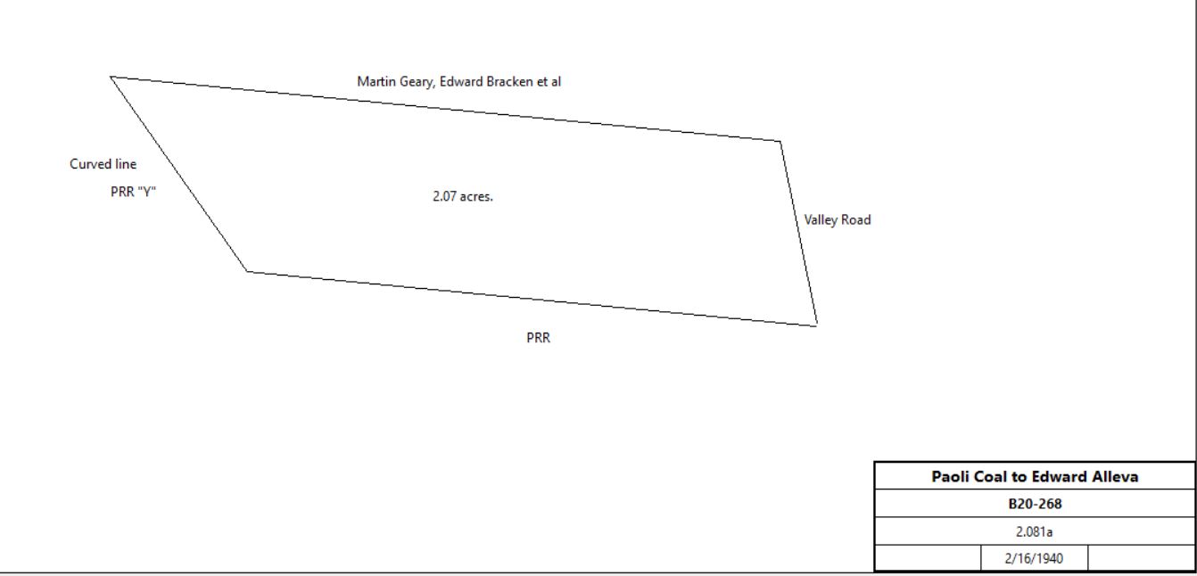
Great Valley Mills |
Paoli Coal & Supply Company |
9/5/1928 |
2.081a |
$1 |
X17-199 |
Paoli Coal & Supply Company |
Edward A. Alleva |
2/16/1940 |
2.081a |
$1 |
B20-268 |
|
Edward A. Alleva |
Bertha Alleva, wife |
1966 |
|
|
died; inheritance |
Estate of Edward A. Alleva |
National Bank of Chester County, Bertha Alleva |
5/19/1966 |
1.5a |
$40,000 |
A38-476; Proceedings of Orphans’ Court. 40 N. Valley Road |
National Bank of Chester County, Bertha Alleva |
Southeast Pennsylvania Transport Authority |
9/3/1985 |
1.5a |
$350,000 |
63-502; Paoli Station parking lot |
Estate of Edward A. Alleva |
|
12/14/1987 |
1.5a |
|
A38-478; Ophans Court |
|
|
|
|
|
|
Edward Alleva |
Harry & Lorretta Shank |
2/5/1947 |
|
$8,500 |
Z22-48; part of B20-268 |
A. Thomas Parke, trustee of the partition of the real estate of Harry & Lorretta Shank |
Edward A. & Bertha Alleva |
4/28/1960 |
not given |
$13,000 |
A32-418 |
Edward A. & Bertha Alleva |
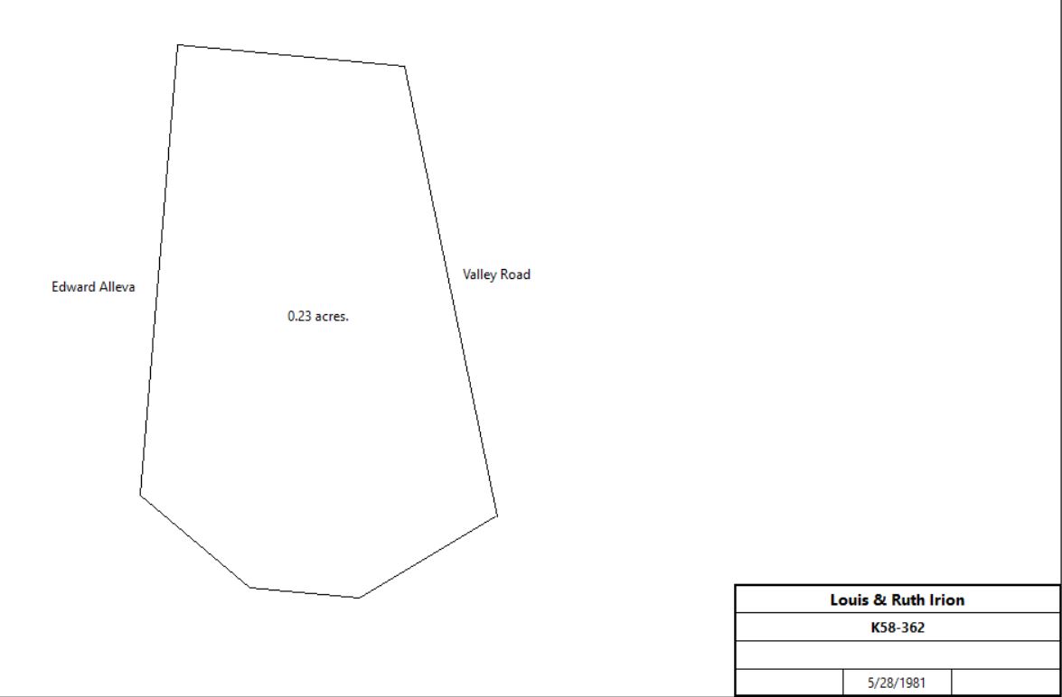
Joseph & Ruby Dudas, Louis & Ruth Irion |
11/17/1960 |
not given |
$16,000 |
R32-372 |
Joseph & Ruby Dudas |
Louis & Ruth Irion |
9/30/1977 |
not given |
$28,000 |
V51-593 |
Louis & Ruth Irion |
Louis & Ruth Irion |
6/8/1981 |
0.1341a |
$1 |
K58-362 |
|
|
|
8/19/1992 |
|
$135,000 |
3194-294 |
|
|
3/18/2008 |
0.1341a |
$1 |
7389-672 |
|
|
8/25/2009 |
0.1341a |
$1 |
7758-724 |
|
|
1/5/2018 |
0.1341a |
$10 |
9678-1206 |
|
|
|
|
|
|
|
|
|
|
|
|
|
Table V.14 - Paoli Hardware Store
|
From |
To |
Date |
Area |
Cost |
Reference |
|
|
|
|
|
|
Paul Dague, sheriff, suit of Girard Trust Co. against Tredyffrin Country Club |
Girard Trust Co. |
6/1/1944 |
|
$1 |
S21-94 |
Girard Trust Co. |
W. Foxall MacElree and Edge Moor Realty Co. |
10/29/1945 |
1) Tredyffrin;
2) Eastern Divison, Tredyffrin;
3) Middle division, Easttown;
4) Western Division, tredyffrin;
5) Tredyffrin 1.02a;
6) Tredyffrin 1.63a |
$97,500 |
S21-332 |
|
|
|
|
|
|
|
|
|
|
|
M15-421 |
Providence Trust Co., and George R. Packard jr., executors of the will of George R. Packard |
W. Foxall MacElree and Edge Moor Realty Co. |
10/25/1945 |
2.793a |
$2,500 |
R21-141 |
W. Foxall and Janie-Belle MacElree |
Joseph and Marion Culhane & Tredyffrin Construction Co. |
5/28/1948 |
1) Tredyffrin;
2) Eastern Divison, Tredyffrin;
3) Middle division, Easttown;
4) Western Division, tredyffrin;
5) Tredyffrin 1.02a;
6) Tredyffrin 1.63a
7) Tredyffrin 1.793a
- 3 lots (3.259a, 0.786a, not given) |
$1 |
H22-500 |
Tredyffrin Construction Co. |
Joseph Culhane |
1/12/1953 |
not given, part of H22-500 |
$16,500 |
Y25-8 |
Joseph and Marian Culhane |
Paoli Markets Inc. |
1/12/1953 |
not given |
$85,000 |
S25-38 |
Paoli Markets Inc. |
William and Connie Divirgilio & Cordine and Marie Scortozzi |
6/1/1955 |
not given, part of S25-38 |
$35,000 |
I28-37 |
William and Connie Divirgilio & Cordine and Marie Scortozzi |
Cordine and Marie Scortozzi |
2/5/1959 |
|
|
V30-513 |
|
Table V.15 - Henry Walley tract
|
From |
To |
Date |
Area |
Cost |
Reference |
|
|
|
|
|
|
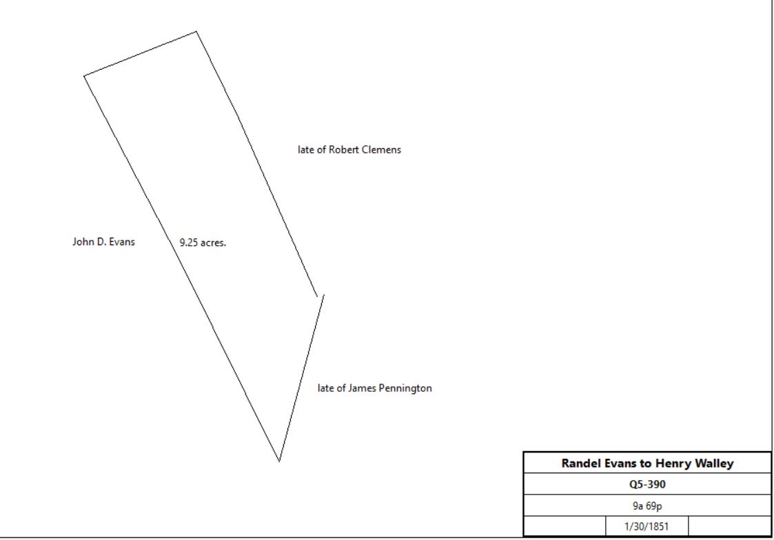
David Bishop, Sheriff, debt of Randel Evans |
Henry Walley |
|
9a 69p |
$433 |
Q5-390; also Sheriff’s deed 5-412 |
 |
|
Table V.16 - Plank Avenue, tract 43-9L-206 and 54-1L-54
|
From |
To |
Date |
Area |
Cost |
Reference |
|
|
|
|
|
|
|
|
|
|
|
See Rees Rhythey purchase for earlier history |
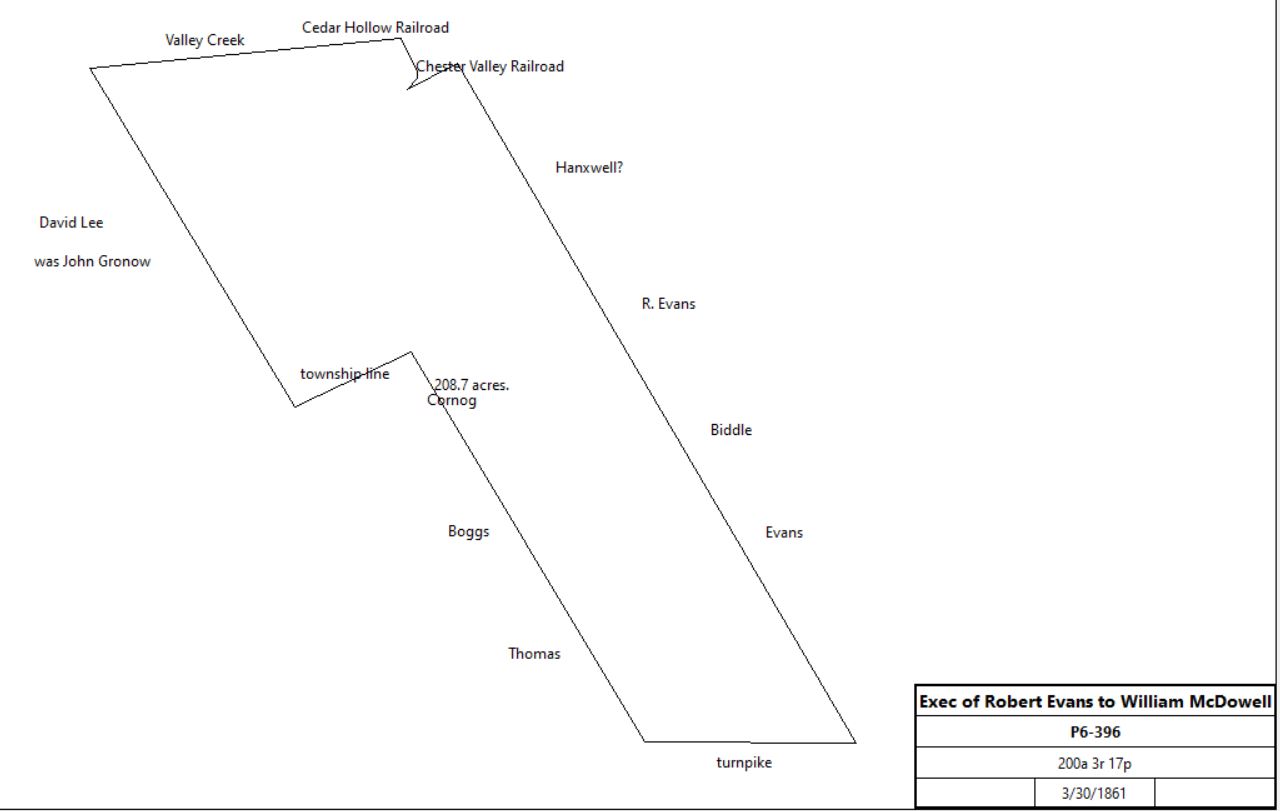
Passmore Williamson, administrator of the estate of Robert T. Evans |
William McDowell |
3/30/1861 |
200a 3r 17p |
$13,256 31c |
P6-396 |
 |
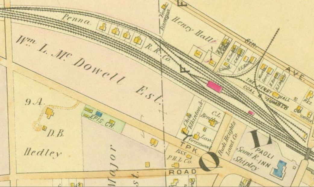 1897 atlas |
heirs of William McDowell |
Levi Suplee |
6/7/1905 |
15.198a + 73.346a (both Willistown) + 0.468a (Tredyffrin) |
$2,000 |
X12-582 |
Levi & Rebecca Suplee |
George Graham |
6/7/1905 |
15.198a + 73.346a (both Willistown) + 0.468a (Tredyffrin) |
$1 |
P12-575 |
George & Pauline Graham |
John Dingee |
8/25/1905 |
14.053a |
$1 |
R12-283 |
Branch A |
Paoli Heights Company |
S. Spencer Chapman |
12/14/1883 |
2.13a |
$1,704 |
S9-297 |
S. Spencer Chapman |
David Hedley |
12/14/1883 |
2.13a |
$2,130 |
S9-299 |
David & Ann Hedley |
Rachel Shoemaker |
12/12/1884 |
2.13a |
$1,704 |
X9-406 |
Rachel Shoemaker |
Robert F. Matthews |
4/2/1908 |
2.31a |
$2,000 |
P13-101 |
Branch B |
|
|
|
|
|
|
John Dingee |
Robert F. Matthews |
7/17/1908 |
11,559.8 ft2 |
$5 |
L13-505; part of R12-283 |
Branch C |
|
|
|
|
|
|
John & Helen Dingee |
George Kohler |
7/17/1908 |
25,972ft2 |
$601 75c |
S13-15 |
George & Annie Kohler |
Robert F. Matthews |
8/24/1908 |
9,505ft2 |
$210 |
Q13-106 |
Branch D |
John & Helen Dingee |
Leroy Garrett |
2/14/1912 |
21,646ft2 |
$500 |
F13-15, Willistown |
Leroy Garrett |
Robert F. Matthews |
6/15/1914 |
21,646ft2 |
$550 |
T14-53 |
|
Robert F. & Eliza Matthews |
Walter T. Matthews |
8/24/1914 |
6,176.625ft2 |
$1 |
V14-215 |
Robert F. & Eliza Matthews |
Harry Weaver |
8/24/1914 |
5,733ft2 |
$1 |
V14-216 |
Robert F. & Eliza Matthews |
Edward Bracken |
6/2/1917 |
4 lots: 2.31a - 34,800ft2 (Tredyffrin) + 11,559.8 ft2 + 9,505ft2 + 9,736.375ft2 |
$13,275 |
E15-116 |
Edward Bracken |
Great Valley Mills |
5/5/1923 |
4 lots: 2.31a - 34,800ft2 + 11,559.8 ft2 + 9,505ft2 + 9,736.375ft2 |
$3,000 |
F16-128 |
Great Valley Mills |
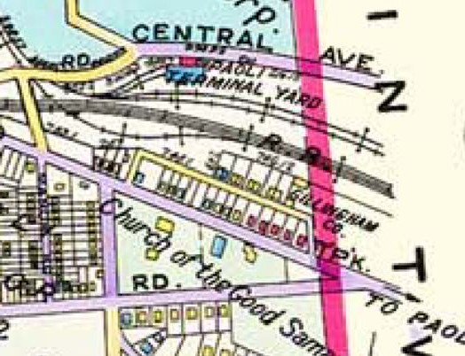
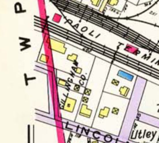
The Gillingham Company |
10/1/1928 |
not quoted |
$1 |
X17-172; part of F16-128 |
The Gillingham Company |
Fred Ludwig |
2/3/1930 |
not quoted |
$1 |
G18-134; Tredyffrin & Willistown |
Fred & Irene Ludwig |
Gillingham Lumber and Woodworking Company |
3/10/1930 |
not quoted |
$1 & mortgages |
G18-148 |
1933 atlas
|
Gillingham Lumber and Woodworking Company |
Joseph Brosius |
11/29/1941 |
not quoted |
$1 |
R20-57 |
Joseph & Ann Brosius |
Brosius & Smedley Inc. |
3/20/1942 |
not quoted |
mortgages |
F21-34 |
Brosius & Smedley |
Joseph Palmer and Clarence Staats |
4/26/1957 |
not quoted |
$105,383 25c |
F29-218 |
Joseph & Jeanette Palmer, Clarence & Jane Staats |
Joseph Palmer |
3/20/1963 |
not quoted |
$75,000 |
A35-553 |
Joseph Palmer |
Chester County Industrial Development Authority |
5/27/1982 |
not quoted |
$1 |
D60-525 |
PALMER JOSEPH E (DEC'D), PALMER JOSEPH E SR (DEC'D), PALMER JOSEPH E JR TRU, DAVIS LINDA P TRU, FEATHERMAN JOHN A III TRU |
|
12/29/1988 |
not quoted |
$1 |
1389-546 |
PALMER JOSEPH E JR DAVIS LINDA P |
|
10/10/2001 |
2.5a |
$1 |
5083-1371 |
DEPOT SHOPPES LP PALMER JOSEPH E JR |
|
3/23/2010 |
2.5a |
$1,504,018 |
7885-1496 |
Depot Shoppes LP |
|
3/23/2010 |
2.5a |
$1,504,018 |
7885-1500 |
|
|
|
|
|
|
|
