|
Note: in these deed histories distances are quoted in perches (p) of length 16.5 feet. Areas are quoted in acres (a) and square perches (p). There are 160 square perches to an acre. In a few cases roods (a quarter of an acre) are also used.
|
|
|
From |
To |
Date |
Area |
Cost |
Reference |
|
|
|
|
|
|
|
John Thomas & Edward Jones |
7/16/1681 |
5,000a |
|
|
|
Hugh & Jane Roberts |
|
625a |
|
|
|
Robert, Owen & Edward Roberts |
6/26/1703 |
212a |
|
|
Proprietors |
Owen & Ann Roberts |
7/28/1714 |
212a or 200a |
|
Patent A5-363 Confirmatory? |
Owen & Ann Roberts |
Thomas Godfrey |
2/4/1719 or 12/16/1719 |
200a |
£40 |
D-415 or 416; Thomas Godfrey in tax record 1715 - 1754 |
Thomas Godfrey |
Morgan Hughes |
11/24/1737 or 9/24/1737 |
109a |
|
Not in recorded; recited in D2-25 |
Morgan Hughes |
Thomas McKean |
4/8/1745 |
109a |
|
Not in recorded; recited in D2-25 |
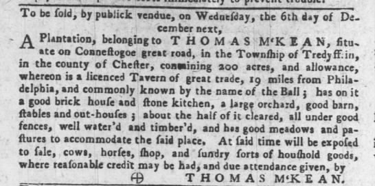
The Philadeplphia Gazette, 11/16/1753
|
Thomas McKean |
Blasius Byers/Beyers |
7/13/1753 or 7/30/1753 |
109a |
|
Not in recorded; recited in D2-25 |
Blasius Byers |
Conrad Young |
9/6/1753 |
109a |
|
Not in recorded |
Conrad Young |
John Moland |
10/25/1753 |
109a & 100a |
£200 |
I-66 Mortgage |
Conrad Young |
John Wister |
6/2/1757 |
109a & 100a |
£177 10s |
K-428 Mortgage |
Conrad & Catherine Young |
Bernadus & Christiana Vanleer |
3/13/1759 |
109a (part of 212a) & 100a |
£700 |
L-242 |
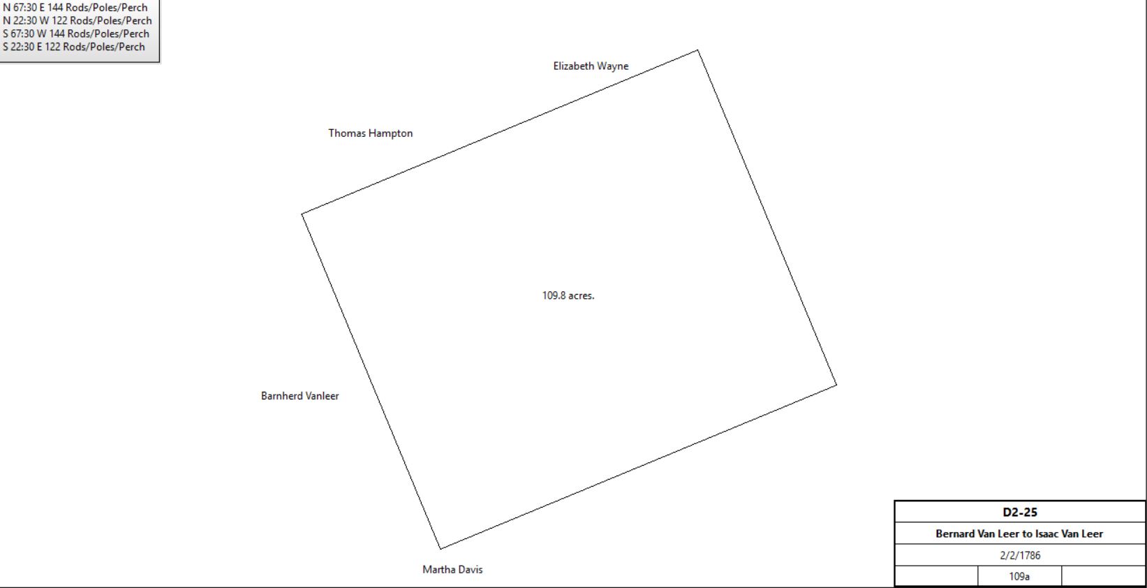
Bernadus & Christiana Vanleer |
Isaac Vanleer |
2/2/1786 |
109a |
5s |
D2-25; see table L.2 |
|
Table L.1 – Mary Moore tract |
Barnard Vanleer |
Daughter Mary Moore during her natural life. |
Died 1/13/1790 |
100a purchased from Conrad Young and 80a from Thomas Hubbert |
|
Will dated 2/10/1786
Thomas Hubbert sale not recorded in Chester County Archives |
|
|
c. 1794 |
|
|
Second Blue Ball Inn constructed |
Mary Moore |
|
1798 |
|
|
Not in Glass tax |
|
William Vanleer |
1809 |
58a 12p |
|
Orphan's Court Docket 11, p. 347. See : The Hatton House |
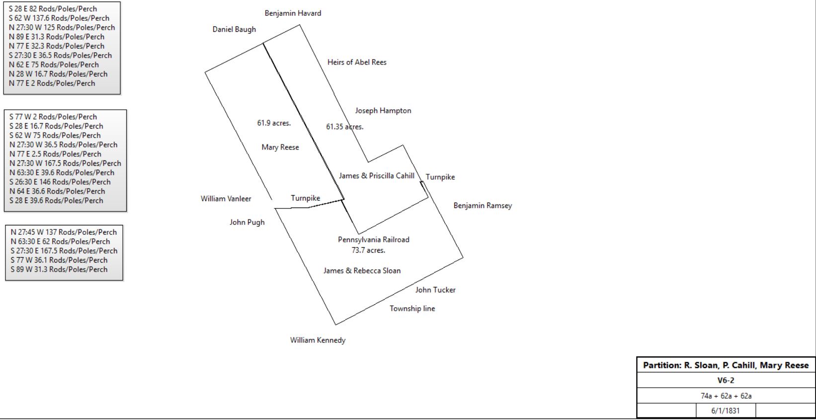
Mary Moore |
Rebecca Sloan, Priscilla Cahill, Mary Reese (daughters) |
1844? |
|
|
died |
Rebecca Sloan, Priscilla Cahill, Mary Reese |
|
1/6/1831 |
74a + 62a + 62a |
|
V6-2; Deed of Partition (see also N4-402 [deed plan] & K4-127) |
|
Table L.1.1 – Mary Reese tract |
Mary Reese |
Violetta M. Kennedy & Mary Ann Sloan (daughters) |
Will 11/5/1874; proven 2/18/1875 |
|
|
Died; will book Y-234 |
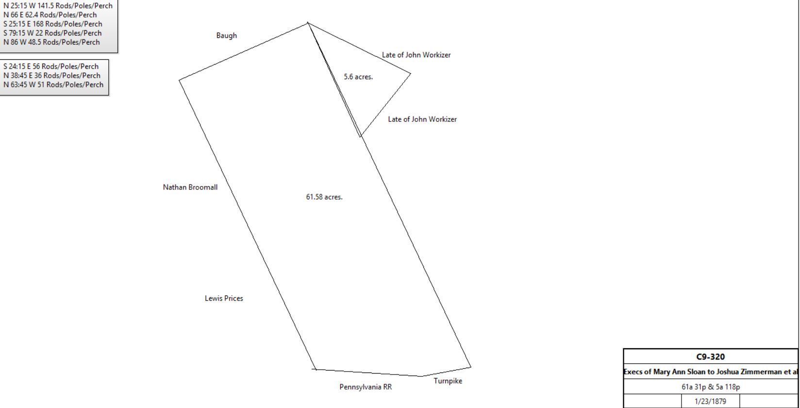
Violetta M. Kennedy & Exec of Mary Ann Sloan |
Joshua Zimmerman & Joshua Kolp |
1/23/1879 |
61a 31p & 5a 118p |
$7027 78c |
C9-320 |
|
J. Zimmerman & J. Kolb |
|
1883 |
61a 31p |
|
Breou’s atlas |
Cope & Fitzsimmon |
|
1887 |
|
|
Atlas |
Jacob Kolb |
|
1897 |
61a 31p |
|
Atlas |
Cressman & Kolb |
|
1900 |
|
|
Atlas |
Josiah Kulp |
Susanna H. Bodine |
3/18/1910 |
½ part of 5a 118p |
$1 |
X13-221 |
Jacob Kolb |
|
1912 |
61a 31p |
|
Atlas |
Caleb Cresson estate |
|
1933 |
|
|
Atlas |
Table L.1.2 - The Second Blue Ball Inn, Priscilla Cahill tract |
James Cahill |
Priscilla Cahill |
? |
62a |
|
died |
Priscilla Cahill |
Mary Reese |
10/19/1868 |
62a |
$5 |
N7-267 |
Mary Reese |
Violetta M. Kennedy & Mary Ann Sloan (daughters) |
Will 11/5/1874; proven 2/18/1875 |
|
|
Died; will book Y-234 |
Sloan & Kennedy |
|
1883 |
57a |
|
Breou’s Atlas |
Sloan & Kennedy |
|
1887 |
|
|
Atlas |
James Sloan, executor of the will of Mary Ann Sloan, Abel & Mary Sloan, Edith Sloan, Abraham and Maryl Brower, George & Violetta Verdies, Anna Sloan, Violetta Kennedy |
Joseph B. Willetts |
3/30/1889 |
55.9a |
$24,540 10c |
N10-237 |
Joseph B. Willetts |
William J. Latta |
3/30/1889 |
55.9a |
$24,540 10c |
L10-269 |
William J. & Kitty Latta |
Wayne Title & Trust Co |
1/13/1891 |
55.9a |
$1 |
V10-124 |
Wayne Title & Trust Co |
William J. Latta |
7/9/1894 |
103.229a |
$1 plus mortgages |
L11-170 |
John P. Croasdale |
|
1897 |
|
|
Atlas |
William J. & Kitty Latta |
John P. Croasdale |
4/17/1899 |
14,806 ft2 |
$339 90c |
C12-133 |
John P. Croasdale |
|
1933 |
|
|
Atlas |
John P. & Mary Gurney Croasdale |
Mae Hoffman |
8/27/1946 |
|
$1 |
S22-230; comprising K11-140, C12-133, I12-461, R12-161, M13-163, Y13-68 |
Mae Hoffman |
John P. & Mary Gurney Croasdale |
8/27/1946 |
|
$1 |
S22-231; comprising K11-140, C12-133, I12-461, R12-161, M13-163, Y13-68 |
John P. Croasdale |
|
1950 |
|
|
|
Mary Gurney Croasdale & Hannah T. Croasdale |
Paul McCurdy Warner & Elinor A. Warner |
3/12/1952 |
1.9194a |
$18,500 |
K25-11; parts of S22-231 and W23-288 |
Elinor A. Warner, widow |
Richard Bailey Ferguson |
7/23/1965 |
1.9194a |
$38,000 |
N36-215 |
Richard Bailey Ferguson |
Ronald E. & Carol M. Kehler |
3/24/1980 |
|
$92,000 |
O56-30 |
Ronald E. & Carol M. Kehler |
Richard Bailey Ferguson |
7/30/1980 |
|
$1 |
E57-21; deed of correction |
Richard Bailey Ferguson |
Ronald E. & Carol M. Kehler |
7/30/1980 |
|
$1 |
E57-26; deed of correction, includes mortgage |
Richard Bailey Ferguson |
Joseph L. & Ada L. Morcini and Joseph J. Morcini |
8/1/1980 |
|
$20,000 |
E57-31; part of O56-30 |
Ron & Carol Kehler |
|
1980 |
|
|
The Blue Ball Inn of Tredyffrin township by Caroline Hager, TEHS Quarterly, vol. 43, #4 (Fall 2006) |
|
|
Patent A5-363 Beginning at post in line of Thomas Reece thence WSW by line of marked trees 278p to post in line of Thomas Edwards, thence by same NNW 100p to corner of said Edwards’ land thence continuing same course 22p to a post in line of Mordecai Moore, thence by same ENE 278p to a corner a marked hickory sapling, thence by said Thomas Rees 122p to the place of beginning.
Containing 200acres and allowance.
D-415 Deed. On 16 Dec 1719 Owen Robert of City of Philadelphia, gentleman, & Anne his wife, to Thomas Godfrey of Treduffin, tailor. Whereas Owen Roberts was granted a tract in Tredufiin bounded by land of Thomas Reese & Thomas Edwards, containing 200 acres, with the allowance of 6 acres per hundred acres being 212 acres confirmed to Owen Roberts 28 July 1714, recorded Philadelphia, Book A, Vol 5, page 363. Now Owen Robert & Anne his wife, for £40 grant to Thomas Godfrey 212 acres. Signed Owen Roberts & Anne Roberts. Delivered in the presence of Edward Roberts, John Cadwalder, Henry Hockley & Aubery Roberts. Recorded 31 Oct 1729. (D4:415).
I-66 Mortgage. On 25 Oct 1753 Conrad Young of Tredyffrin, inn holder & Catherine his wife, to John Moland of the City of Philadelphia, gentleman. Conrad Young & Catherine his wife for £200 granted to John Moland a tract in Tredyffrin bounded by land of Benjamin Ellis, Justice Harris, Humphrey Wayne, William Sharp & other land of Conrad Young containing 109 acres & another tract bounded by land of Francis Wayne, Benjamin Ellis, Thomas Hubert, William Sharp & Morgan Hughes containing 100 acres. Conrad Young & Catherine his wife to pay John Moland £200 plus interest on 25 Oct 1754. Signed Conrad Young & Catherine Young (wrote in dutch) [sic]. Delivered in the presence of Benjamin Lergh & George Read. Recorded 19 Nov 1753.
K-428 Mortgage. On 2 June 1757 Conrad Young of Chester County, yeoman, & Catherine his wife to John Wister of the City of Philadelphia. Conrad Young stands bound to John Wister for £355 conditioned on payment of £177.10 plus interest on 15 July next. Conrad Young & Catherina his wife for to better secure said debt granted to John Wister 2 tracts in Tredyffrin, one bounded by land of Benjamin Ellis, Justice Harris, Humphrey Wayne, William Sharp & other land of Conrad Young containing 109 acres & the other tract bounded by land of Francis Waynes, Benjamin Ellis, Thomas Hubbart, William Sharp & Morgan Hughes containing 100 acres. Signed Conrad Young & Catherina Young. Delivered in the presence of Aubrey Bevan & Joseph Galloway. Recorded 9 June 1757.
L-242 On 13 Mar 1759 Conrad Young late of the County of Chester but now residing in the City of Philadelphia, yeoman, & Catherine his wife to Bernhard Van Leer of Marple, practioner of physick.. Conrad Young & Catherine his wife for £700 granted to Bernhard Van Leer a plantation & tracts of land in Tredyffrin, one bounded by land of Benjamin Ellis, Justice Harris, Humphrey Wayne, William Sharp & other land of Conrad Young containing 109 acres, the other tract bounded by land of Francis Wayne, Benjamin Ellis, Thomas Hubbert, William Sharp, & Morgan Hughes containing 100 acres. Signed Conrad Young & Catherine Young. Delivered in the presence of Benjamin Weatherby & John Broby. Recorded 5 May 1759.
|
Table L.1.2.1 |
From |
To |
Date |
Area |
Cost |
Reference |
|
|
|
|
|
|
Louis M. Childs |
Susanna H. Bodine |
10/22/1910 |
18.393a |
$6,098 25c |
A14-162; see Susanna Bodine sales and purchases |
Susanna H. Bodine |
William Armstrong |
12/26/1946 |
|
$1 |
D23-8; part of A14-162 |
William Armstrong |
Hannah T. Croasdale |
12/12/1949 |
|
$850 |
W23-288 |
|
|
Table L.2 – Isaac Vanleer tract - eastern part of Owen Roberts patent
|
From |
To |
Date |
Area |
Cost |
Reference |
|
|
|
|
|
|
Bernadus & Christiana Vanleer |
Isaac Vanleer |
2/2/1786 |
109a |
5s |
D2-25; from Table L |
|
Isaac Vanleer |
|
1798 |
103a |
|
Glass tax |
Isaac Vanleer |
|
5/4/1809 |
54a; 56a; 58a 12p |
|
Died 1799; property split |

|
Partition after Isaac Vanleer’s death |
Bernard Vanleer |
1809 |
54a |
|
Estate #4723. Admin. docket #2, p. 444 |
Partition after Isaac Vanleer’s death |
Isaac Vanleer junior |
1809 |
56a |
|
Estate #4723. Eldest son |
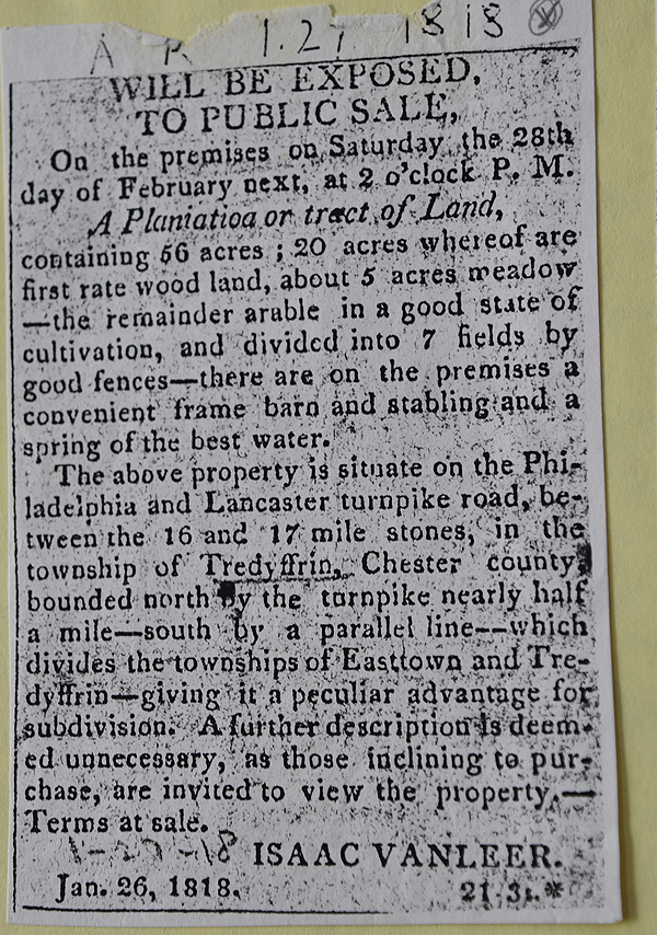
American Republican 1-27-1818
See Newspaper clipping in Document database for commentary
|
Partition after Isaac Vanleer’s death |
William Vanleer |
1809 |
58a 12p |
|
Estate #4723. Orphans Court Docket 11, p. 347 |
Isaac Vanleer |
John Pugh |
4/15/1822 |
22a 150p |
|
W3-37 (described in U4-83) |
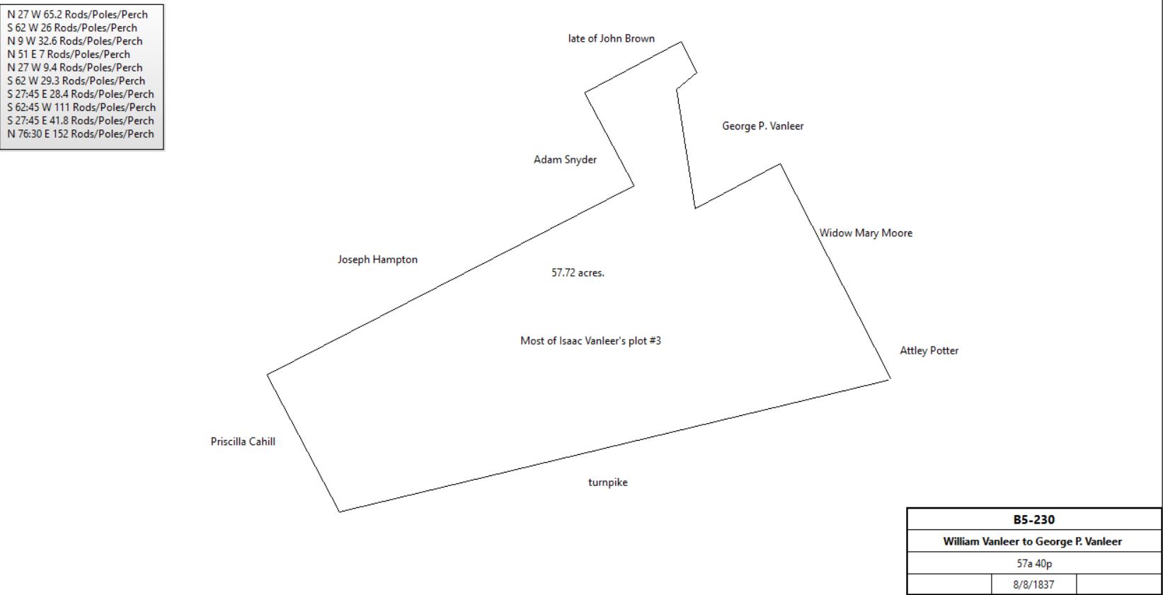
William & Sarah Vanleer |
George R. Vanleer |
8/8/1837 |
57a 40p |
$2,280 |
B5-230; lot #3 of Isaac Vanleer property |
|
William Vanleer |
|
1847 |
|
|
Died |
Sarah Vanleer |
George R. Vanleer |
3/15/1851 |
35a |
$1,645 |
Z6-13; no detailed description of tract |
George R. Vanleer |
Director of Common Schools in the District of Tredyffrin Township |
4/26/1852 |
½a |
$100 |
R5-330; Mt. Airy School, see table L.2.1 |
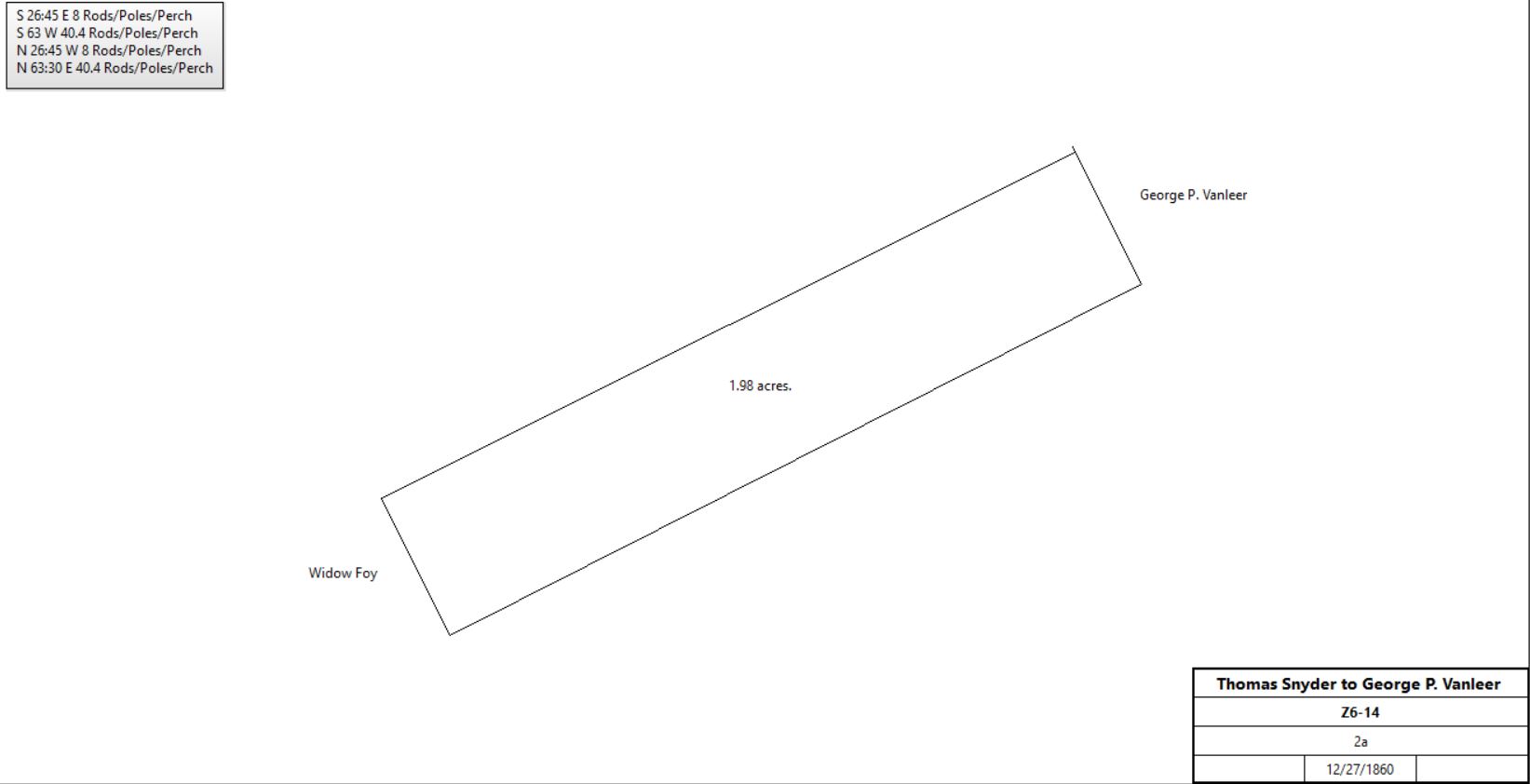
Thomas & Lydia Snyder |
George R. Vanleer |
12/27/1860 |
2a |
$150 |
Z6-14 |
|
George Vanleer |
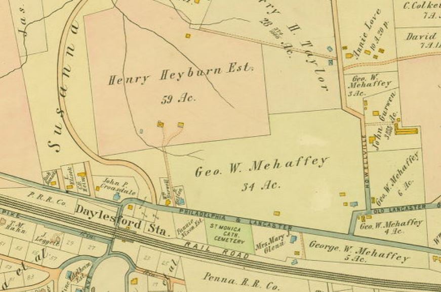
George Mehaffey |
5/16/1864 |
57a 40p + 35a + 2a |
$15,000 |
Y6-319; first tract same description as B5-230; second tract no description, but neighbours Attley Potter, Stephen Lammey, Robert Glenn, George Vanleer and others. |
George & Charlotte Mehaffey |
Francis Hooter |
7/28/1866 |
57a 40p + 35a + 2a |
$15,000 |
E7-243 |
Francis Hooter |
Charlotte Mehaffey |
7/28/1866 |
57a 40p + 35a + 2a |
$15,000 |
E7-244 |
George & Charlotte Mehaffey |
Pennsylvania Railroad |
11/27/1873 |
0.66a |
$181 50c |
L8-57; south side of railroad |
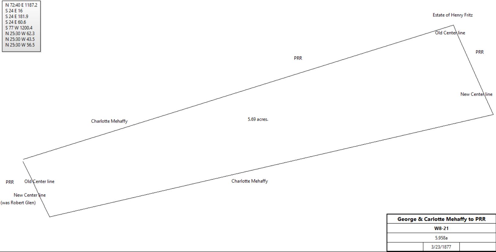
George & Charlotte Mehaffey |
Pennsylvania Railroad |
3/23/1877 |
5.958a |
$1,370 |
W8-21 |
|
George Mehaffey |
|
1883 |
94a |
|
Breou’s Atlas |

|
George & Charlotte Mehaffey |
William Dawson |
10/9/1893 |
0.323a |
$350 |
D11-120; betweem Berwyn - Paoli road and the railroad. |
George & Charlotte Mehaffey |
Hannah Epright |
3/19/1894 |
0.459a |
$700 |
D11-393 |
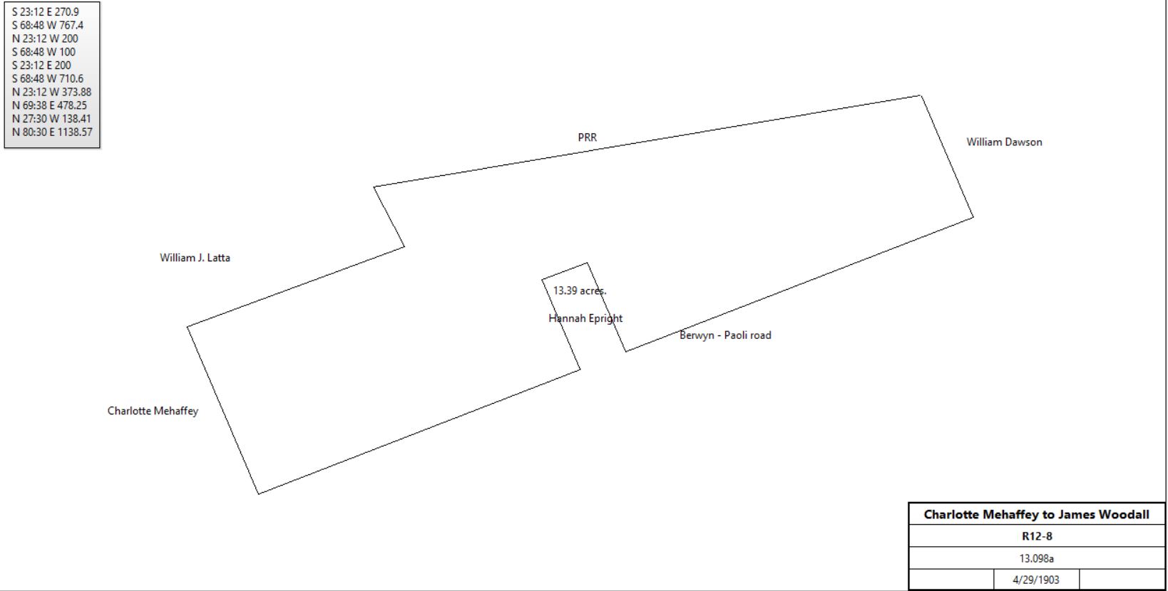
Charlotte Mehaffey |
James Woodall |
4/29/1903 |
13.098a |
$22,266 60c |
R12-8; part of E7-244 |
|
James Woodall |
M.R.E. & T. |
4/29/1903 |
13.098a |
|
X12-252 |
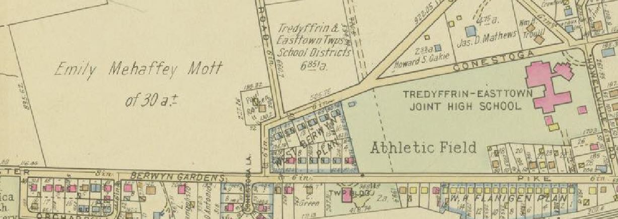
Emily Mehaffey Mott |
School district |
7/12/1948 |
6.861 |
$7,474 |
X23-219 |
|
Table L.2.1 – Hatton House
See The Story of a House : A History of the Hatton House on Old Lancaster Road
|
From |
To |
Date |
Area |
Cost |
Reference |
|
|
|
|
|
|
Director of Common Schools in the District of Tredyffrin Township |
Edmund E. & Susan B. Hatton |
5/1/1905 |
0.553a |
$500 |
X12-493 |
Edmund E. & Susan B. Hatton |
Edward F. Bracken |
8/31/1923 |
|
$3350 |
D13-575 |
Edward F. Bracken |
John Frazer |
10/18/1923 |
|
|
I16-196 |
John Frazer |
Mary E. Boyd |
3/17/1925 |
|
|
S16-254 |
Mary E. Boyd |
John Frazer |
1/3/1930 |
|
|
H18-294 |
John Frazer |
George W. & Irene A. Kenney |
5/19/1930 |
|
|
K18-502 |
George W. & Irene A. Kenney |
Charles Fenno Hoffman |
1932 |
|
|
Q16-528 |
Charles Fenno Hoffman |
David W. & Beryl K. Patterson |
10/30/1945 |
|
$4,000 |
F22-236 |
David W. & Beryl K. Patterson |
Henry K. & Maria K. Bardsley |
9/3/1953 |
|
|
I23-216 |
Henry K. & Maria K. Bardsley |
Charles John Jr. & Carolyn E. Bergh |
3/5/1958 |
|
$19,500 |
Z29-56 |
Charles John Jr. & Carolyn E. Bergh |
Mark L. & Judith A. Tunnell |
20/7/1979 |
|
$62,000 |
H55-431 |
|
Table L.2.2 – van Leer Cabin
See Conrad Wilson / Van Leer Log Cabin
; Dating the van Leer Cabin
|
From |
To |
Date |
Area |
Cost |
Reference |
|
|
|
|
|
|
J. van Leer |
|
1883 |
|
|
Breou’s 1883 atlas |
David Hause (trustee of William van Leer’s estate) |
Miles Lawless |
3/31/1884 |
4a 142p |
$1260 |
Y9-239 |
M. Lawless |
|
1887 |
|
|
1887 atlas |
Miles Lawless |
|
1897 |
|
|
1897 atlas |
Miles Lawless |
|
1900 |
5a |
|
1900 atlas |
John Curwen |
|
1908 |
3.974a |
|
1908 atlas |
John Curwen |
|
1912 |
3.974a |
|
1912 atlas |
George Mahaffey estate |
|
1920 |
3a |
|
1920 atlas |
John Curwen |
|
1920 |
3.974a |
|
1920 atlas |
John Curwen |
|
1926 |
3 + 3.974a |
|
1926 atlas |
John Curwin |
|
1933 |
3 + 3.974a |
|
1933 atlas |
John Curwen |
|
1950 |
6.974a |
|
1950 atlas |
Mrs. Curwin |
School District |
2/1956 |
87 Irish Road |
|
See article above |
|
|
|
Moved to Conestoga High School |
|
|
|
From |
To |
Date |
Area |
Cost |
Reference |
|
|
|
|
|
|
|
|
1724 |
|
|
Also called Half-way house. Date on fireplace |
|
Robert Richardson |
1735 |
|
|
|
Robert Richardson |
|
1739 |
|
|
County tax |
Robert Richardson |
|
1741 |
|
|
|
Thomas McKean |
|
1741 |
|
|
Application for license |
Conrad Young |
|
1752 |
|
|
Name changed to King of Prussia for 2 years |
Benjamin Weatherby |
|
1762 |
|
|
Application for license |
Benjamin Weatherby |
|
1766 |
|
|
Died; Administration |
Hannah Weatherby (widow) |
|
1766 |
|
|
Application for license |
Philip Eppright |
|
1771 - 6 |
|
|
Held license |
Thomas Reese |
|
1777 |
|
|
Damaged by British plundering (Goshen?) |
Isaac Vanleer senior |
Isaac Vanleer junior |
1809 |
56a |
|
Died intestate |
Isaac Vanleer |
John Pugh |
4/15/1822 |
22a 150p |
$1,111 25c |
W3-37 |
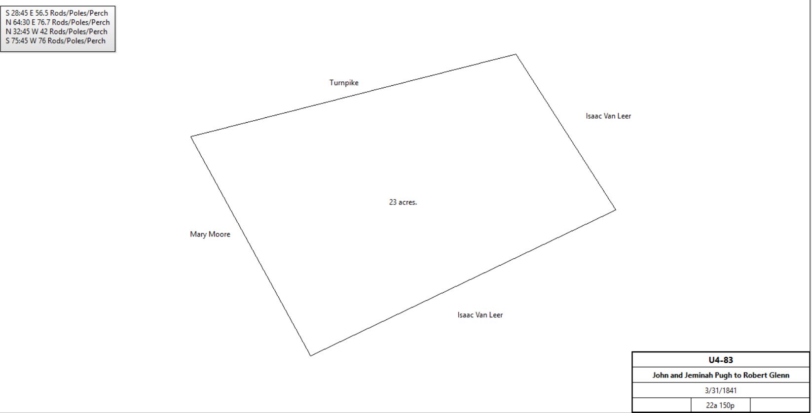
John & Jeminah Pugh |
Robert Glenn |
3/31/1841 |
22a 150p |
$2,100 |
U4-83; (astride railroad) |
|
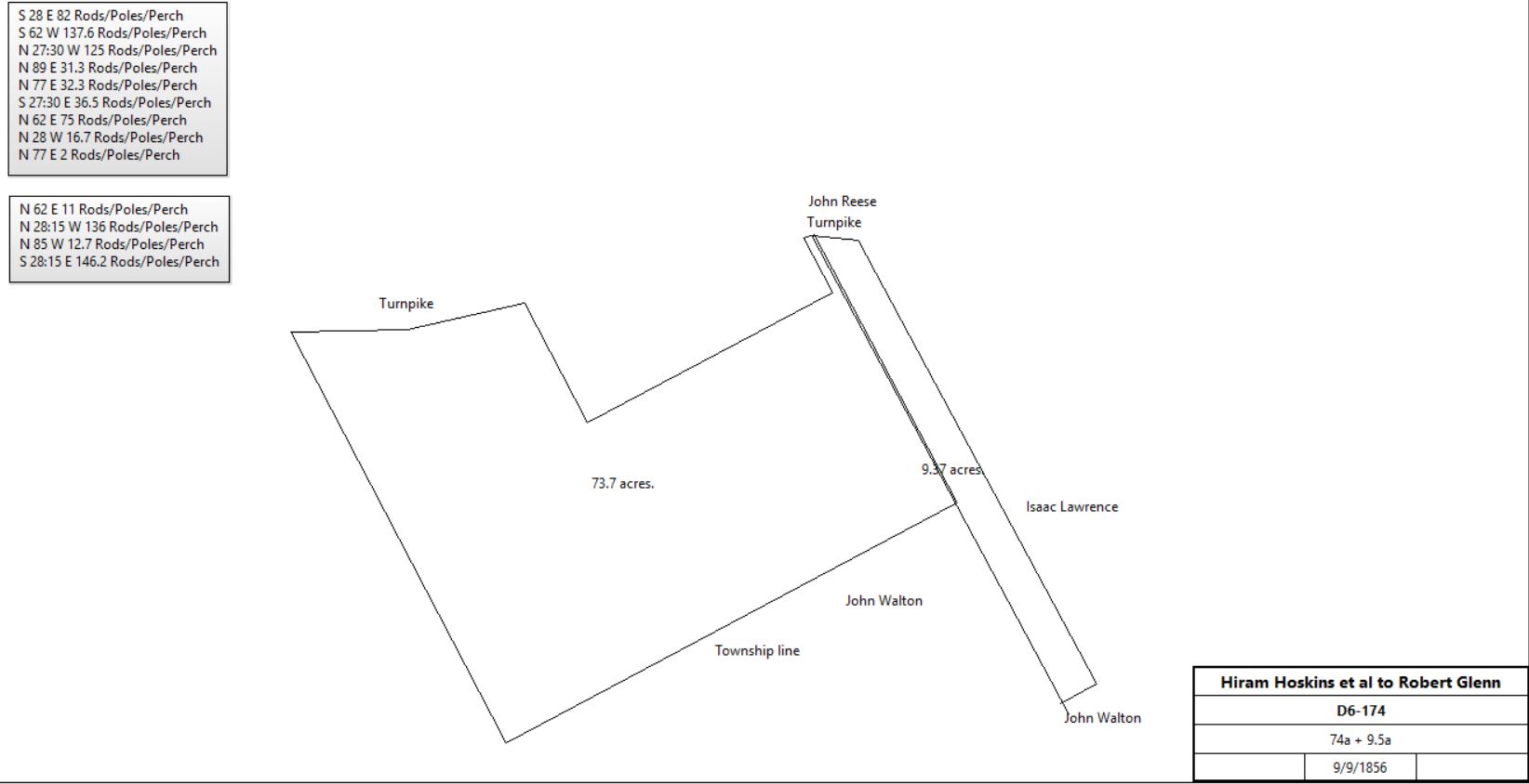
Hiram & Mary Hoskins and Robert & Rebecca Jarden |
Robert Glenn |
9/9/1856 |
74a + 9.5a |
$6,708 |
D6-174 |
Robert & Jane Glenn |
Pennsylvania Railroad |
11/7/1876 |
3.863a + 2.582a |
$6,215 |
U8-147; parts of U4-83 (above) and D6-174 (below). Plan problematic. |
Pennsylvania Railroad |
Tredyffrin Land Company |
12/23/1918 |
0.138a |
$100 |
?-148 |
|
|
|
|
|
|
James & Priscilla Cahill, Mary Reese, widow |
James & Rebecca Sloan |
1/6/1831 |
74a |
|
N4-402; see deed plan V6-2 above |
Stephen & Elizabeth Leamy |
James & Rebecca Sloan |
3/27/1841 |
9.5a |
$1,050 |
U4-514; Easttown & Tredyffrin |
James Sloan |
Rebecca Sloan |
1/1/1846 |
|
|
Will |
Rebecca Sloan |
Mary Hoskins & Rebecca Ann Jordan (daughters) |
10/18/1853 |
|
|
Will |
Hiram & Mary Hoskins, Robert & Rebecca Ann Jordan |
Robert Glenn |
9/9/1856 |
74a + 9.5a |
$6,780 |
D6-174 |
|
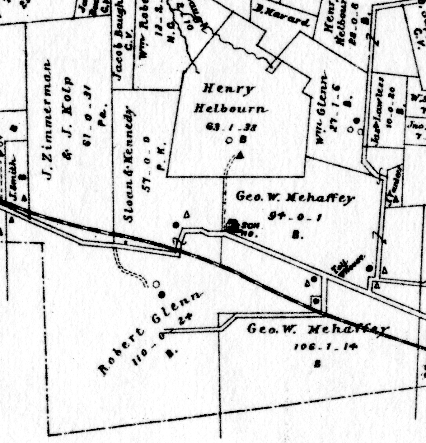
Robert Glenn |
|
1883 |
110a 24p |
|
Breou; Tredyyfrin |
|
Robert Glenn |
|
1883 |
125a 38p |
|
Breou; Easttown |
Robert Glenn & wife |
William J. Latta |
3/29/1889 |
112a |
$52,896 |
O10-126 |
William J. & Kitty Latta |
Pennsylvania Railroad |
3/15/1890 |
0.914a + 0.571a + 0.628a |
$498 60c |
T10-10; land for Daylesford station |
Pennsylvania Railroad |
William J. Latta |
3/15/1890 |
1.282a |
See conveyance above for net price |
Q10-498 |
Robert Glenn |
|
1892 |
8a |
|
Estate file #1624 |
Robert Glenn |
|
|
110 Glenn Avenue |
|
2003 Historic Resources Survey of Tredyffrin Township, p. 157 |
William J. Latta |
|
1894 |
153a |
|
Tax |
William J. Latta |
Olney Crosdale |
|
|
|
Many deeds |
Wayne Title & Trust Co. |
Richard Graham |
5/14/1891 |
1.589a + 1a |
$2,589 |
X10-135; plots #20 and #110; part of V10-124 |
Richard & Clara F. Graham |
John P. Croasdale |
9/28/1894 |
1a |
$3,500 |
K11-140 |
Richard Graham |
|
1897 |
|
|
Atlas |
Richard Graham |
|
1900 |
|
|
Atlas |
Richard & Clara Graham |
William J. Latta |
6/25/1902 |
52.548a + 103.229a |
$500 |
P12-358; quit claim |
|
|
|
|
|
|
William & Kitty Latta |
Olney Croasdale |
2/10/1904 |
|
|
S12-85 |
Olney Croasdale |
Caroline Edelheim |
5/26/1904 |
2.427a; parts of P12-302 and S12-85 |
$2,180 |
R12-129 |
William & Kitty Latta |
Babette Newton |
1/8/1906 |
8.042a + 960 ft2 |
$5,629 40c |
Y12-53 |
Emily E. Crosdale |
|
1912 |
|
|
Atlas |
Estate of Caroline Edelheim |
|
1912 |
|
|
Atlas |
Heirs of Emily E. Crosdale |
Caroline Newton |
11/15/1941 |
1a |
$18,000 |
Q20-294 |
Heirs of Emily E. Crosdale |
Caroline Newton |
6/1/1942 |
0.149a |
$500 |
B21-211 |
|
Table L.3.1 – Oak Knoll
|
From |
To |
Date |
Area |
Cost |
Reference |
|
|
|
|
|
|
William J. Latta |
Babette Edelheim Newton |
10/30/1894 |
2.529a |
$2,529 |
E11-1 |
William J. & Kitty Latta |
Babette Edelheim Newton |
9/16/1895 |
1.989a |
$2,582 |
M11-54 |
A. E. Newton |
|
1897 |
|
|
Atlas |
Mrs A. E. Newton |
|
1900 |
|
|
Atlas |
William Latta |
Babette Newton |
1/8/1906 |
8.042a + 960 ft2 |
$5,629 40c |
Y12-53 |
A. E. Newton |
|
1912 |
15a |
|
Atlas |
Chester County Trust Company |
Babette E. Newton |
11/25/1912 |
3.537a + 6.612a |
$8,329 60c |
H14-538; Lots #27, 29, 57 + 11, 13, 13, 17, 92, 94, 96 |
Eugene Warden |
Babette E. Newton |
12/2/1912 |
|
|
H14-541 |
Fannie E. Nixon |
Babette E. Newton |
8/9/1913 |
|
|
R14-44 |
Penn Railroad Co. |
Babette E. Newton |
4/19/1921 |
1.384a |
$2,200 |
V15-356 |
A. E. Newton |
|
1933 |
28a |
|
Atlas |
|
Table L.3.2 – William J. Latta developments
|
From |
To |
Date |
Area |
Cost |
Reference |
|
|
|
|
|
|
William J. & Kitty B. Latta |
Richard Graham |
5/29/1890 |
1a |
$1,000 |
T10-89 |
Richard & Clara Graham |
C. S. Schwartz |
6/10/1896 |
1a |
$3,000 |
O11-294; 2 story stone messuage |
C. S. Schwartz |
Clara Graham |
6/10/1896 |
1a |
$3,000 |
O11-295 |
Richard & Clara Graham |
Emily Croasdale |
5/13/1903 |
1a |
$3,600 |
S12-24 |
Emily Croasdale |
Olney Croasdale |
5/26/1904 |
0.225a |
$1 |
R12-132 |
|
|
|
|
|
|
William J. & Kitty B. Latta |
Amos Heansell |
9/19/1890 |
1.202a |
$1,202 |
W10-41; tract #24; now 1424 Pennsylvania Avenue |
William J. & Kitty B. Latta |
Clement Cooper |
9/19/1890 |
1.19a |
$1,190 |
V10-77; tract #22; now 1420 Pennsylvania Avenue |
William J. & Kitty B. Latta |
Joshua Wainwright |
1891 |
? |
$255 |
U10-65; tract #34 |
|
|
|
|
|
|
William J. & Kitty B. Latta |
The Wayne Title & Trust Co. |
1/13/1891 |
55.9a + 112.489a - 1.129a (to PRR) |
$1 |
V10-124 |
|
|
|
|
|
|
The Wayne Title & Trust Co. |
Richard Graham |
5/14/1891 |
1.589a (lot #20) + 1a (lot #110) |
$2,589 |
X10-135 |
William Turner, Sheriff |
The Peoples Trust Savings & Deposit Company |
12/22/1902 |
1.589a |
|
Sheriff’s Deed Book 11-138 |
The Peoples Trust Savings & Deposit Company |
Olney Croasdale |
5/9/1903 |
1.589a |
$1,638 |
P12-302; lot #20 |
Olney & Dorothy Croasdale |
Emily Croasdale |
5/26/1904 |
0.149a |
$1 |
R12-131; part of P12-302 |
|
|
|
|
|
|
|
|
|
|
|
|
The Wayne Title & Trust Co. |
Dallas Saunders |
5/20/1893 |
0.913a + 0.918a + 0.981a |
$2,555 70c |
B11-551; lots #31, 33, 35 |
Dallas Sauders |
Thomas M. Hahn |
10/10/1904 |
? |
$1 |
S12-131 |
T. H. Hahn |
|
|
|
|
1912 atlas |
|
|
|
|
|
|
|
|
|
|
|
|
The Wayne Title & Trust Co. |
William & Lydia Burwell |
6/26/1893 |
0.575a + 0.292a |
$744 |
F11-48; lots #106 & 115 |
William Burwell |
Gertrude E., Helen, Jennie M. Burwell, daughters |
|
|
|
died |
Susanna H. Bodine |
Gertrude E., Helen, Jennie M. Burwell |
9/30/1947 |
not given |
$1 |
M23-196, part of A14-162 |
Susanna H. Bodine |
Gertrude E., Helen, Jennie M. Burwell |
11/4/1947 |
not given |
$1 |
P23-9 |
|
|
|
|
|
|
The Wayne Title & Trust Co. |
William J. Latta |
7/9/1894 |
52.548a + 103.239a |
$1 |
L11-170 |
William J. & Kitty B. Latta |
Olney Croasdale |
6/1/1901 |
0.836a |
$600 |
E11-447 |
Olney Croasdale |
John P. Croasdale |
3/23/1903 |
0.836a |
$1 |
I12-461; part of E11-447 |
|
|
|
|
|
|
William J. & Kitty B. Latta |
Olney Croasdale |
3/6/1903 |
3.573a |
$3,573 |
E12-276; next to Newton & Richard Graham properties |
|
|
|
|
|
|
Richard & Clara Graham |
William J. Latta |
6/25/1902 |
52.548a (excepting lots #20 and #110) + 103.239a |
$500 |
P12-358; quit claim |
William J. & Kitty B. Latta |
Charles H. C. Franklin |
11/14/1906 |
1.292a |
$1,200 |
S12-290 |
|
|
|
|
|
|
|
|
|
|
|
|
William J. & Kitty B. Latta |
John P. Croasdale |
9/10/1903 |
35,994ft2 or 0.826a |
$743.40 |
R12-161; lots #103 & 109 |
|
|
|
|
|
|
William J. & Kitty B. Latta |
Frances R. Wilson |
11/4/1903 |
0.918a |
$700 |
S12-63 |
William J. & Kitty B. Latta |
Olney Croasdale |
2/10/1904 |
1.251a |
$1,000 |
S12-85; lot #18? |
|
|
|
|
|
|
William J. & Kitty B. Latta |
Dorothy Croasdale |
1/8/1906 |
1.251a |
$1,000 |
Y12-52; lot #10 |
Olney & Dorothy Croasdale |
Fred T. Lewis |
1/20/1906 |
1.251a |
$1 |
S12-228 |
Fred T. Lewis |
Olney Croasdale |
1/20/1906 |
1.251a |
$1 |
S12-229 |
|
|
|
|
|
|
William J. & Kitty B. Latta |
John P. Croasdale |
7/15/1907 |
15,000ft2 + 17,667ft2 |
$6,074 10c |
M13-163; lots #118 & 121 |
|
|
|
|
|
|
William J. & Kitty B. Latta |
Chester County Trust Co. |
8/20/1908 |
62.502a + 6.612a |
$1 |
P13-248 |
|
|
|
|
|
|
Chester County Trust Co. |
Strickland L. Kneass |
5/9/1910 |
2.616a |
$2877.60 |
Y13-2; lots #26 and 28 |
|
Table L.3.3 – Susanna Bodine
|
From |
To |
Date |
Area |
Cost |
Reference |
|
|
|
|
|
|
John Franklin Keller & Lancaster Trust Company, trustees of the will of John Keller |
Susanna Bodine |
5/18/1903 |
16.156a |
$4,039 |
T12-21 |
Henry & Louisa Jacobs |
Susanna Bodine |
2/1/1905 |
120p |
$850 |
Q12-567 |
|
|
|
|
|
|
John Franklin Keller & Lancaster Trust Company, executors of the will of John Keller |
Margaret & Sabine Petery |
5/18/1903 |
1.786a |
$1,200 |
P12-311; see table P.2.1 |
Henry & Margaret, Joseph & Sabine Petery |
Susanna Bodine |
1/30/1905 |
1.786a |
$7,450 |
R12-205 |
|
|
|
|
|
|
John Franklin Keller & Lancaster Trust Company, executors of the will of John Keller |
Susanna Bodine |
6/20/1905 |
2.054a |
$1.027 |
X12-574 |
Allen & Rebecca Evans et al |
Susanna Bodine |
6/16/1905 |
17.77a |
$7,996 50c |
X12-586 |
John Franklin Keller & Lancaster Trust Company, executors of the will of John Keller |
Susanna H. Bodine |
10/16/1905 |
12,954ft2 |
$1 |
V12-413 |
Violetta R. Kennedy & Mary K. Gunkle, executors of the will of Violet Rees Kennedy |
Susanna H. Bodine |
1905 |
77a |
$11,000 |
P12-585; see table AH.4 |
|
|
|
|
|
|
|
|
|
|
|
|
Horace & Anna Churchman |
Susanna H. Bodine |
12/23/1908 |
20.691a |
$1 |
T13-37; see table A, Branch B |
|
|
|
|
|
|
Maskell & Alice Ewing |
|
1/2/1909 |
31.03a |
$1 |
T13-52 |
Louis M. & Alice H. Childs and Jacob R. & Josephine V. Yost |
Susanna H. Bodine |
2/17/1910 |
15a |
$1 |
X13-111 |
|
|
|
|
|
R13-280 |
Josiah Kulp |
Susanna H. Bodine |
3/18/1910 |
5a 118p |
$1 |
X13-221; see Mary Reese tract |
William H. & Mabel Fritz and Henry Fritz |
Susanna H. Bodine |
6/27/1910 |
0.999a |
$1 |
X13-353 |
|
|
|
|
|
A14-88 |
|
|
|
|
|
X13-380 |
|
|
|
|
|
W13-511 |
|
|
|
|
|
X13-412 |
|
|
|
|
|
|
Louis M. Childs |
Susanna H. Bodine |
10/22/1910 |
18.393a |
$6,098 25c |
A14-162 |
S. Laurence & Susanna H. Bodine |
John P. Croasdale |
3/4/1911 |
1,517ft2 |
$1 |
Y13-68; part of lot #117 |
|
|
|
|
|
|
|
|
|
|
|
E14-282 |
|
|
|
|
|
I14-235 |
|
|
|
|
|
F13-334 |
|
|
|
|
|
F15-256 |
|
|
|
|
|
F15-422 |
|
|
|
|
|
T15-13 |
|
|
|
|
|
T15-14 |
|
|
|
|
|
T15-72 |
|
|
|
|
|
T15-73 |
|
|
|
|
|
V15-425 |
|
|
|
|
|
|
|
Table L.3.4 – William Vanleer
|
From |
To |
Date |
Area |
Cost |
Reference |
|
|
|
|
|
|
Issac Vanleer |
William Vanleer |
|
58a |
|
died intestate; partition |
William & Sarah Vanleer |
George P. Vanleer, son |
8/8/1837 |
57a 40p |
$2,280 |
B5-230 |
Sarah Vanleer |
George P. Vanleer |
3/15/1851 |
35a |
$1,645 |
Z6-13 |
|
|
|
|
|
|
|
Adam Snyder |
|
|
|
deed not found |
Adam Snyder |
George Snyder |
9/22/1837 (will date) |
|
|
Bequest |
George & Lydia Snyder |
George P. Vanleer |
12/27/1860 |
2a |
$150 |
Z6-14 |
|
George P. Vanleer |
George W. Mehaffy |
5/16/1864 |
57a 40p + 35a + 2a |
$15,000 |
Y6-319 |
George W. Mehaffy |
Francis C. Hooten |
7/28/1866 |
57a 40p + 35a + 2a |
$15,000 |
E7-243 |
Francis C. Hooten |
Charlotte R. Mehaffy (wife of George W. Mehaffy) |
7/28/1866 |
57a 40p + 35a + 2a |
$15,000 |
E7-244 |
Charlotte R. Mehaffy |
George W. Mehaffy |
4/27/1908 |
|
|
died |
George W. Mehaffy |
David R. Mehaffy, Gertrude Mehaffy, Emily M. Mott, children |
7/1/1910 |
|
|
died |
Daylesford, 1912
|
David R. Mehaffy |
Gertrude Mehaffy, Emily M. Mott |
7/29/1934 |
|
|
died intestate |
Gertrude Mehaffy |
Emily M. Mott |
6/15/1935 |
57a 40p + 35a + 2a - various tracts |
$1 |
S18-435 |
West Berwyn development |
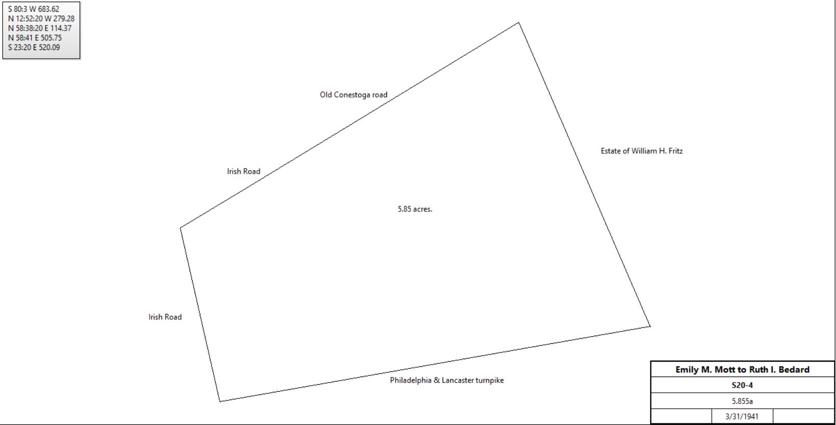
Emily M. Mott |
Ruth I. Bedard |
3/31/1941 |
5.855a |
$1 |
S20-4 |
|
Ruth I. Bedard |
Robert G. & Alma P. Funkhouser |
4/1/1941 |
5.855a |
$1 |
V20-131 |
Robert G. & Alma P. Funkhouser |
Ruth I. Bedard |
3/30/1942 |
9 lots, part of V20-131 |
$1 |
F21-28 |
Ruth I. Bedard |
Robert G. & Alma P. Funkhouser |
5/8/1942 |
9 lots, same as F21-28 |
|
F21-58 |
Robert G. & Alma P. Funkhouser |
Ida H. Sumerfield |
9/2/1942 |
12,397 ft2 |
$1 |
F21-118; |
West Berwyn from 1950 Mainline atlas
|
|
|
|
|
|
|
Robert G. & Alma P. Funkhouser |
John & Dorothy Buzzell |
1/29/1942 |
11,690 ft2 |
$1 |
F21-9 |
John & Dorothy Buzzell |
John & Dorothy Buzzell, Barbara Ann Swigert, Karen F. Diconstanzo (daughters) |
12/14/1984 |
11,690 ft2 |
$1 |
T64-417 |
Dorothy E. Buzzell |
Barbara Ann Swigert, Karen F. Diconstanzo |
8/10/1993 |
11,690 ft2 |
$1 |
3604-1404 |
Dorothy E. Buzzell, Barbara Ann Swigert, Karen F. Diconstanzo |
Henry & Mary Jane Toroni |
6/16/1995 |
11,690 ft2 |
$134, 900 |
3903-1605; 996 Old Lancaster Pike; #43 LOT 7 OLD LANCASTER PIKE MISC1: 43-10K-71 |
Other Emily Mott sales |
From |
To |
Date |
Area |
Cost |
Reference |
|
|
|
|
|
|
Emily M. Mott |
Melvin C. & Elizabeth B. Long |
5/29/1951 |
14.5893a |
$17,507 16c |
T24-84 |
Emily M. Mott |
Melvin C. & Elizabeth B. Long |
9/4/1951 |
17.8316a |
$21,397 92c |
U24-63 |
|
|
|
|
|
|
Emily M. Mott |
Mary E. Brown |
3/2/1940 |
1a |
|
Z19-279 |
Emily M. Mott |
Katherine A. Williams |
9/16/1940 |
- |
$1 |
M20-155; part of S18-435; Windywood |
Emily M. Mott |
Tredyffrin township |
12/6/1940 |
2a |
|
L20-235 |
Emily M. Mott |
Berwyn Building Co. |
1/8/1941 |
1.294a |
|
L20-268 |
Emily M. Mott |
Carl Gust & Margaret E. Green |
2/28/1941 |
1a |
|
O20-355 |
Emily M. Mott |
Luigi & Yoland Evangelisto |
7/17/1941 |
1.139a |
|
T20-264 |
Emily M. Mott |
Katherine A. Williams |
7/23/1941 |
- |
$1 |
W20-6; part of E7-244 |
Emily M. Mott |
Lillian & Russell D Antonio |
1/22/1942 |
|
|
B21-16 |
Emily M. Mott |
Berwyn Building Co., Leary Edna R. & Lawrence A. |
3/18/1946 |
|
|
Q22-201 |
Emily M. Mott |
Tredyffrin - Easttown School district |
7/21/1948 |
6.851a |
|
X23-219 |
Emily M. Mott |
Joseph W. Espenshade |
3/12/1949 |
|
|
V23-112 |
Emily M. Mott |
Anna E. Tinsman |
12/28/1950 |
|
|
I24-294 |
Emily M. Mott |
Blanche C. & John G. Schilling |
4/27/1951 |
|
$3,200 |
L24-276; part of E7-244 |
Manor Real Estate development |
From |
To |
Date |
Area |
Cost |
Reference |
|
|
|
|
|
|
|
|
|
|
|
|
William & Kitty Latta |
Pennsylvania Railroad |
6/24/1903 |
11.974a |
|
P12-329; part of L11-170 above |
Pennsylvania Railroad |
Manor Real Estate & Trust Co. |
3/17/1924 |
|
|
Not recorded |
Manor Real Estate & Trust Co. |
Raymond Burns |
4/3/1924 |
22,057 ft2 + 17,590 ft2 |
$1,250 |
L16-152 |
Raymond Burns |
Henry O. Garber |
11/27/1925 |
|
|
V16-478 |
Henry O. Garber |
Edna Burns & Elizabeth Pyle |
9/14/1943 |
|
|
Died intestate |
Raymond & Edna Burns, Elizabeth & Abram Pyle |
Lawrence & Edna Leary |
4/11/1947 |
22,057 ft2 + 17,590 ft2 |
$2,100 |
Y22-163 |
|
