|
Note: in these deed histories distances are quoted in perches (p) of length 16.5 feet. Areas are quoted in acres (a) and square perches (p). There are 160 square perches to an acre. In a few cases roods (a quarter of an acre) are also used.
|
|
|
From |
To |
Date |
Area |
Cost |
Reference |
|
|
|
|
|
|
Penn |
William Mordaunt or Mordaint |
10/24/1681 |
500a |
|
Patent B-2-106 |
|
|
1703 |
607a |
|
Warrant: resurvey |
William Mordant |
Thomas Mordant, heir |
|
|
|
died |
Thomas & Osmond Mordant, sons |
John Evans |
1/28/1711 |
500a |
|
|
Capt. Mordant |
|
1715 |
|
|
County Tax: Non-resident. John Evans not in tax list |
John Evans |
John Moore |
3/5/1716 |
607a |
|
Phil. E7-10-374 or N-434 |
Capt. Mordant |
|
1718 |
500a |
|
County Tax: Non-resident. John Evans & John Moore not in tax list |
Capt. Mordant |
|
1719 |
|
|
County Tax: Non-resident. John Evans & John Moore not in tax list |
John Moore |
Thomas James |
7/7/1720 |
607a |
|
Release Phil. F3-243 (2/9/1721) or N-434; Resurveyed |
Thomas James |
|
1721 |
|
|
County Tax |
Thomas James |
|
1724 |
|
|
House shown on road plan |
Thomas James |
|
1739 |
|
|
County Tax |
Thomas James |
|
12/19/1739 |
630a |
|
Resurveyed, see Survey B3-111 and Survey B3-112 |
Thomas James |
Ann James, widow in her life, then Lewis James |
Dated 12/8/1750 |
|
|
Will |
Ann James |
Lewis James of Trehaide, Pembrokeshire, South Wales |
2/23/1753 |
607a |
£500 |
N-436. See tables C.1 and C.3 for sales. |
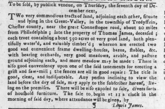
The Philadelphia Gazette, 11/16/1753
|
|
|
John Evans was the Lieutenant Governor of Pa. and heavily involved in acquiring land during this period. John Moore was a whig and the Customs Collector. The Evans/Moore relationship was not strictly business as Evans married Moore's daughter in 1708 (from Great Valley House).
Quoted in W2-466: Beginning at a black oak marked at the corner of Thomas Jerman’s land, thence by the same NNW 496p to a post, thence ENE by line of marked trees 196p to a post, SSE 496p to a Spanish oak, thence WSW by Mordecai Moore’s land 196p to place of beginning. 607a
N-434 Release. On 7 July 1720 John Moore of the City of Philadelphia, esquire, to Thomas James of Radnor, yeoman. Whereas William Penn by deed dated 24 and 25 Oct 1681 granted to William Mordent alias Mordaunt, of Llanstenwell in the County of Pembroke, esq., dec. 500 acres in the province of Pennsylvania as recorded in Philadelphia, Book B, vol 2, folio 106 & 107. Whereas William Mordent intended to give the 500 acres to his younger son, Osmond but died before he made the conveyance. Whereas the 500 acres descended to Thomas Mordent, son & hier of William Mordent, who being willing that his brother, Osmond should have the said 500 acres, did therefore with Osmond by deed dated 28 Jan 1711 granted the 500 acres to John Evans of Denbigh in the County of Denbigh (under the name of John Evans late of Philadelphia but now of London, esquire). Whereas John Evans by deed dated 5 Mar 1716 granted the 500 acres to John Moore, as recorded in Philadelphia, Book E7, vol. 10, page 374. Whereas by warrant dated 13 Mar 1684 the said 500 acres was laid out to William Mordent, & was resurveyed in 1703 and found to be in the Great Valley bounded by land of Thomas Jerman containing 607 acres. John Moore for £210 granted to Thomas James all the 607 acres. Signed John Moore. Delivered in the presence of Mirick Davies & William Davies. On 6 Aug 1764 before Benjamin Franklin esq. one of the justices of the peace, appeared Charles Brockden, recorder of deeds for the City and County of Philadelphia, whereas the above written deed was shown to him, & upon his solemn affirmation believes that the same deed was signed, sealed, and delivered by John Moore, late of the City of Philadelphia, esq., in the presence of Mirick Davies late of Frankfort of the County of Philadelphia, scrivener. Signed C. Brockden in the presence of B. Franklin. Recorded 26 Sep 1764. |
|
Table C.1
|
From |
To |
Date |
Area |
Cost |
Reference |
|
|
|
|
|
|
Lewis James |
John Kinkade |
2/24/1753 |
322a |
|
Unrecorded. Southern section; north boundary Valley Creek |
John Kinkade |
Lewis James |
2/26/1753 |
322a |
£500 |
H-524 Mortgage |
Lewis James |
Robert Moore |
6/1/1753 |
322a |
£500 |
I-43 Assignment of mortgage. |
John Kinkead |
Bernhard Van Leer |
12/5/1757 |
322 – 40a |
£55 |
K-529 Mortgage |
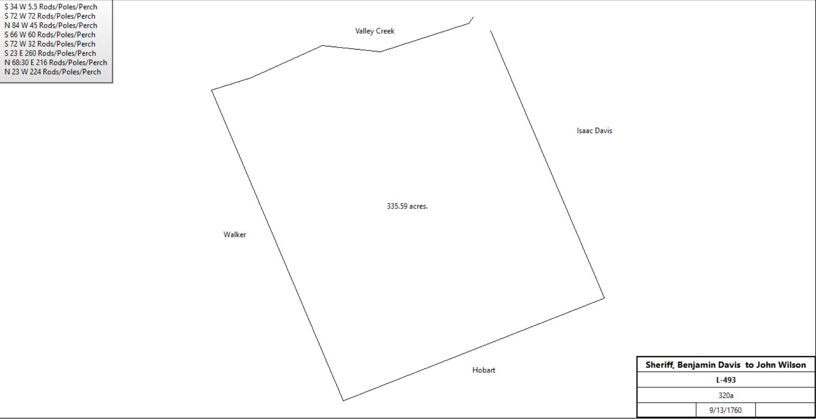
Benjamin Davis, sheriff |
John Wilson |
9/13/1760 |
322a |
£500 |
L-493 |
 |
John & Judeth Wilson |
Isaac Davis |
|
30a (out of 322) |
|
? No sign of deed; See table G.1 for Isaac Davis' property history. |
John Wilson |
John Kinkead |
9/18/1760 |
322 - 30a |
£600 |
L-508 Mortgage |
John Kinkead |
Mary Maddox |
9/22/1760 |
|
£613 12s |
L-509 Assignment of mortgage |
John & Judeth Wilson |
David Wilson (son) |
1779 |
112a |
|
Z-287; see table C.1.1 |
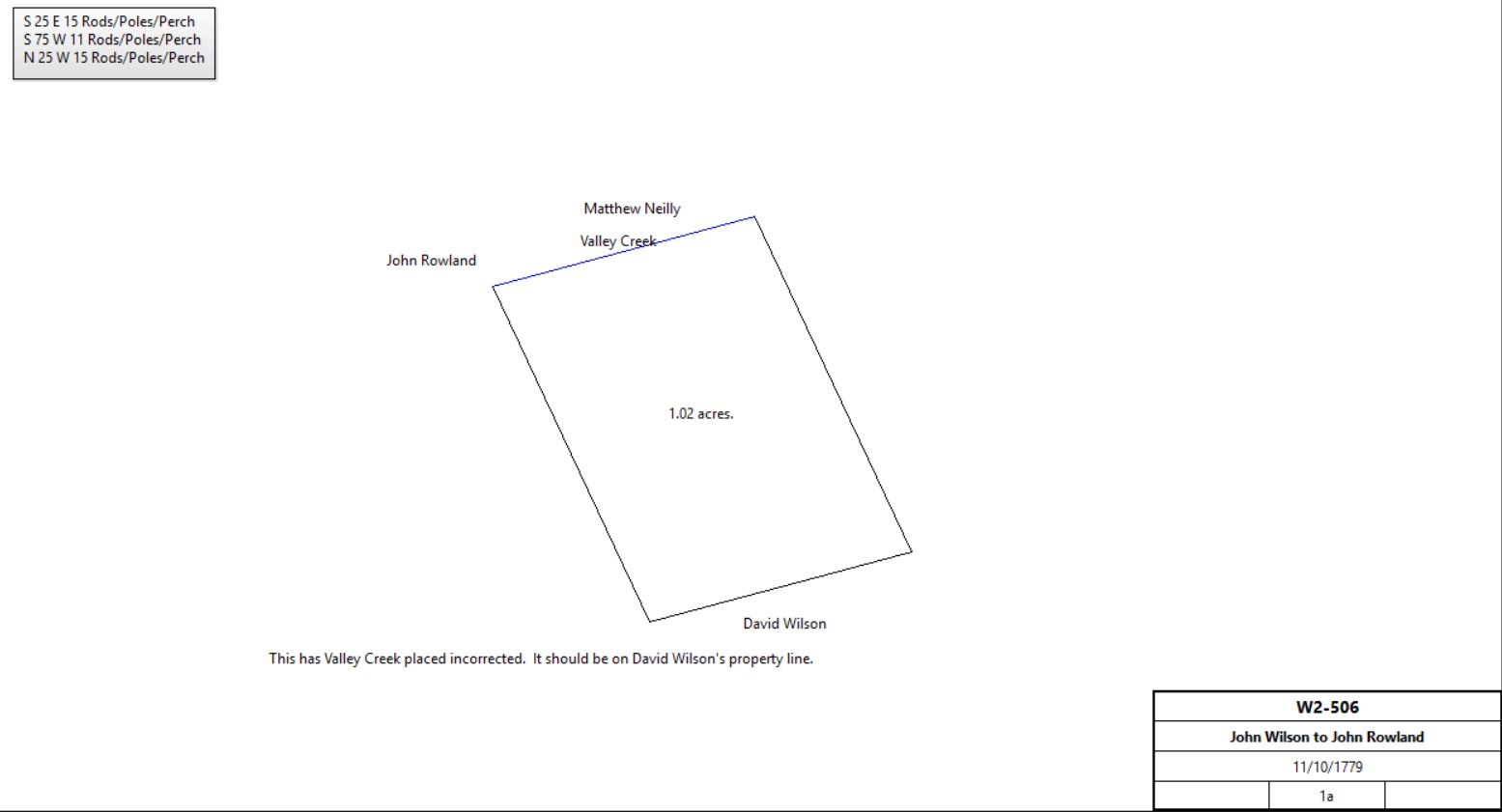
Francis Alison |
David Wilson |
10/23/1779 |
1a |
|
Phila. D-3-268; next to Valley Creek |
John Wilson |
|
1783 |
180a |
|
tax |
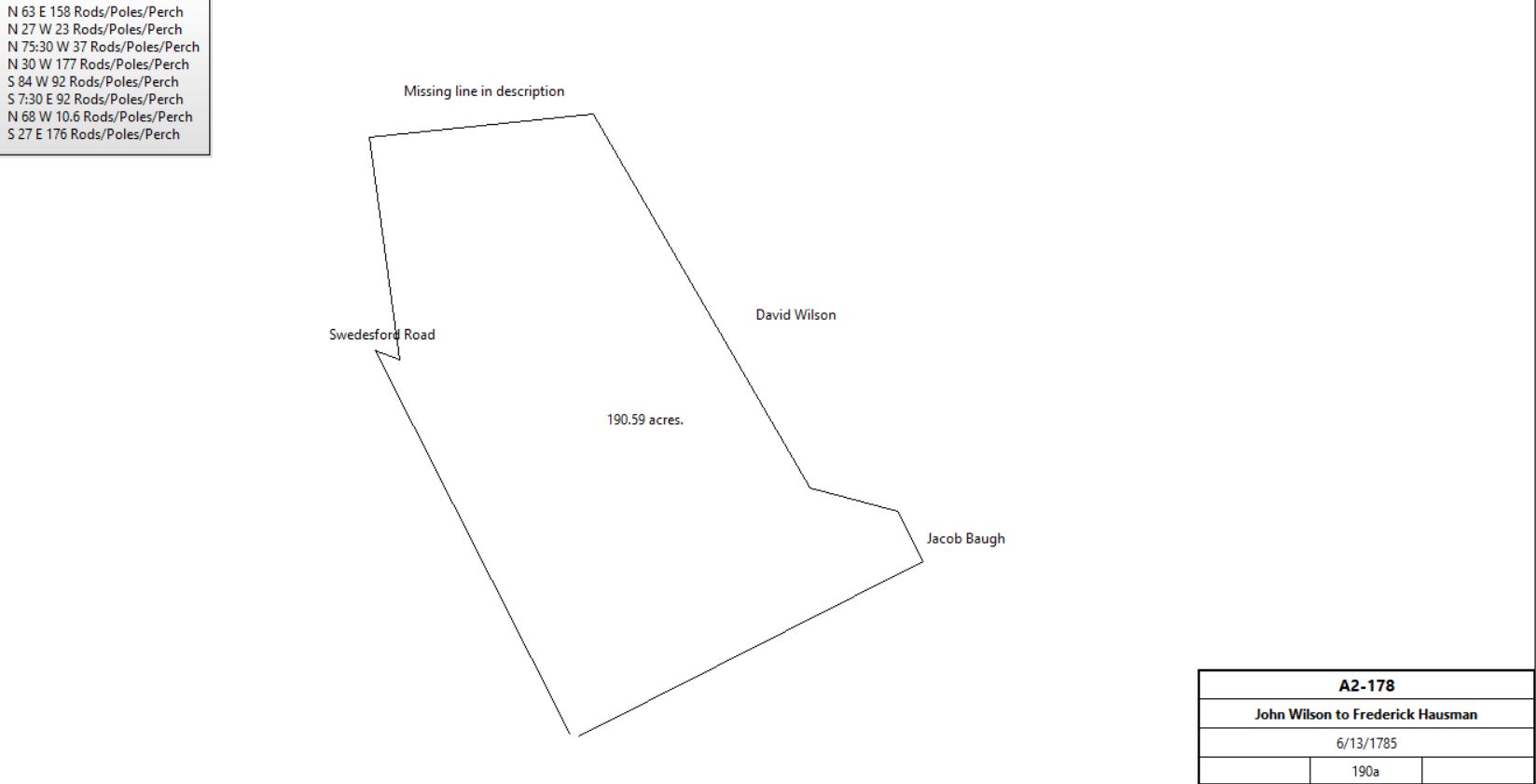
John & Judeth Wilson |
Frederick Hausman |
6/13/1785 |
190a |
|
A2-178, see table C.1.2 |
Frederick Houseman |
|
1785 |
180a |
|
tax |
David Wilson |
|
1798 |
106a |
|
Glass tax |
David Wilson |
David Wilson jr. |
1826 |
|
|
Died |
|
David Wilson jr. |
1836 |
101a |
|
|
David Wilson |
Samuel Karnaghan |
2/13/1843 |
6.5a 22p |
$278 77c |
Y4-379 |
Samuel Karnaghan |
Richard Evans |
8/21/1847 |
9.5a 27p + 6.5a 22p |
$907 23c |
K5-199; see Table G for history of first tract |
David Wilson jr |
Winfield Scott Wilson |
|
|
|
Probably Inheritance |
Winfield Scott Wilson |
David Wilson |
|
|
|
|
David Wilson |
Ruth Anna Wilson |
|
|
|
Wife |
Ruth Anna Wilson |
William West Wilson & Winfield Scott Wilson |
|
|
|
Sons |
John M. Wilson |
|
1883 |
111a |
|
Breou map |
|
|
H-524 Mortgage. On 26 Feb 1753 John Kinkade of Tredyffrin, clerk, to Lewis James of TreHaidd in Pembrokeshire of South Wales in Old England, gentleman. John Kinkade stands bound to Lewis James for 1000 pounds conditioned on payment of 500 pounds on I May 1754. John Kinkade to better secure said payment grants to Lewis James a tract in the Great Valley bounded by land of David John, Valley Creek, land of Walker, Hobard & Isaac Davis, containing 322 acres, being the same land Lewis James by deed dated 24 Feb 1753 granted to John Kinkade. Signed John Kinkade. Delivered in the presence of Francis Alison, Thomas Bartholemew & Paul Isaac. Recorded 16 May 1753.
I-43 Assignment of Mortgage. On I June 1763 Lewis James of Tre Haidd in Pembroke Shire in South Wales, gentleman, to Robert Moore of the city of Philadelphia, merchant, Whereas John Kinkead of Tredyffrin in the county of Chester, clerk, by deed dated 26 Feb last became bound to James Lewis for 1000 pounds conditioned on payment of 500 pounds plus interest on 1 May 1754. Whereas John Kinkead by way of security for the debt granted a tract of land in the Great Valley bounded by land of David John, Valley Creek, land of Walker, Hobard & Isaac Davis containing 322 acres, recorded in Chester, Book H, Vol 8, Page 524. Now Lewis James for 500 pounds paid by Robert Moore, grants to Robert Moore the said mortgage. Signed Lewis James. Delivered in the presence of James Johnston & Josiah Jackson. Recorded 2 Oct 1753.
K-529 Mortgage. On 5 Dec 1757 John Kinkead of Tredyffrin, clerk & Annie his wife to Doctor Bernhard Van Leer of Marple. John Kinkead & Annie his wife for 55 pounds granted to Dr. Bernhard Van Leer a tract of land in the Great Valley bounded by land of David John, Valley Creek, Walker's land, Hobbard's land & land of Isaac Davis containing 322 acres (except 40 acres). John Kinkead to pay 55 pounds on 1 Sep 1758. Signed John Kinkead & Annie Kinkead. Delivered in the presence of James Mather & Rebecca Mather. Recorded 27 Jan 1758.
L-493 Sheriff's Deed. On 13 Sep 1760 Benjamin Davis, Sheriff of Chester County to John Wilson of Tredyffrin, Esquire. Whereas John Kinkead of Chester County, clerk by mortgage dated 26 Feb 1753 did mortgage the here after described tract of land to Lewis James to secure payment of 500 pounds on the date mentioned, long since passed. Whereas the mortgage monies not being paid the said Lewis James by deed dated 1 June 1753 did granted to Robert Moore all the monies mentioned & the tract of land. Whereas Robert Moore made his will in writing & appointed William Moore, executor. Whereas William Moore in the Court of Common Pleas recovered against John Kinkead a debt of 500 pounds & 72 shillings damages to be levied on the lands of John Kinkead. Whereas Benjamin Davis, Sheriff, for 500 pounds granted to John Wilson a tract of land in the Great Valley bounded by land of David John, Valley Creek & land of Isaac Davis containing 322 acres. Signed Benjamin Davis, sheriff. Delivered in the presence of Henry H. Graham & E. Price. Recorded 17 Sep 1760.
L-508 Mortgage. On 18 Sep 1760 John Wilson of the County of Chester, yeoman to John Kinkead of Chester County, clerk. John Wilson stands bound to John Kinkead for 200 pounds yearly conditioned on payment of 100 pounds plus interest on 1 May 1761 through 1 May 1766. John Wilson to better secure said 600 pounds granted to John Kinkead a tract of land in the Great Valley bounded by land of David John, the Valley Creek, land of Walker, Hobard, Isaac David containing 322 acres, excepting 30 acres lately granted by John Wilson to Isaac Davis. Signed John Wilson & Judeth Wilson. Delivered in the presence of Isaac Wayne & John Johnston. Recorded 1 Nov 1760.
L-509 Assignment of Mortgage. On 22 Sep 1760 John Kinkead of Chester County, clerk to Mary Maddox of the City of Philadelphia, widow. John Kinkead for 613.12 pounds granted & assigned bond or mortgage from John Wilson to John Kinkead dated 18 Sep 1760. Signed John Kinkead. Delivered in the presence of Paul Isaac Voto & Sarah Voto. Recorded 7 Nov 1760.
|
Table C.1.1 David Wilson Farm
|
From |
To |
Date |
Area |
Cost |
Reference |
|
|
|
|
|
|
David Wilson |
|
1778 |
90a? |
|
Tax; freeman |
David Wilson |
|
1779 |
112a |
|
tax |
David Wilson |
|
1781 |
112a |
|
tax |
David Wilson |
|
1783 |
112a |
|
tax |
David Wilson |
|
1785 |
112a |
|
tax |
David Wilson |
|
1786 |
112a |
|
tax |
David Wilson |
|
1787 |
112a |
|
tax |
David Wilson |
|
1788 |
112a |
|
tax |
David Wilson |
|
1789 |
112a |
|
tax |
David Wilson |
|
1791 |
106a |
|
tax |
David Wilson |
|
1795 |
106a + 30a hill |
|
tax |
David Willson |
|
1797 |
136a |
|
tax |
David Wilson |
|
1798 |
108a |
|
Glass tax. Including John Wilson house, stone 32’ x 27’ |
David Wilson |
|
1798 |
136a |
|
tax |
David Wilson |
|
1799 |
106a |
|
tax |
|
Table C.1.2 Upper Stream Farm / Great Valley House
|
|
There is confusion in the records here. The description of both places quote the same sale, but there seems to be only one messuage, and there is only one stone house in the 1798 glass tax
|
From |
To |
Date |
Area |
Cost |
Reference |
|
|
|
|
|
|
John Wilson |
|
1767 |
180a |
|
tax |
John Wilson |
|
1779 |
4a |
|
tax |
John Wilson |
|
1781 |
180a |
|
tax |
John Wilson |
|
1783 |
180a |
|
tax |
John & Judeth Wilson |
Frederick Hausman |
6/13/1785 |
190a |
£2700 |
A2-178, from table C.1 Including John Wilson house, aka The Great Valley House. A date stone in the west peak of the house is inscribed "Fredrick Houseman 1791". The west part of the house was added by Fredrick Houseman and the addition, the "modern" part of the house, was completed in the year 1791. |
 |
Frederick Hausman ux |
John Wilson |
1785 |
190a |
|
Mortgage B-210. Paid off 1793 |
Frederick Hausman |
|
1785 |
180a |
|
tax |
Frederick Hausman |
|
1786 |
180a |
|
tax |
Frederick Hausman |
|
1787 |
180a |
|
tax |
Frederick Hausman |
|
1788 |
180a |
|
tax |
Frederick Hausman |
|
1789 |
180a |
|
tax |
Frederick Hausman |
|
1791 |
180a |
|
tax |
Frederick Hausman |
|
1795 |
180a |
|
tax |
Frederick Hausman |
|
1797 |
180a |
|
tax |
Frederick Hausman |
|
1798 |
182a |
|
Glass tax: House: Stone 33' x 24' 2 floors.
Windows: 11 windows with 15 panes.
Stone Addition 24' x 19'; Stone Kitchen 24' x 17'; Stone Springhouse 16' x 12'; Log Barn 38' x 24'; Smith shop 24' x 18';
Log House 1 floor (occupier Frederick Houseman jr.); Windows: 2 windows with 9 panes; 2 windows with 8 panes. |
Frederick Hausman |
|
1798 |
183a |
|
tax |
Frederick Hausman |
|
1799 |
183a |
|
tax |
Fredrick Houseman |
|
3/12/1800 |
|
|
Died |
Heirs of Fredrick Houseman |
George Beaver (son-in-law) |
|
|
$3664 |
|
George Beaver & Susanna |
John & Christian Zook |
3/13/1801 |
190a |
|
messuage and tract |
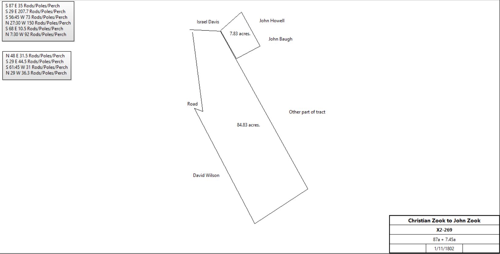
Christian Zook & Magdalena |
John Zook |
1/11/1802 |
87a + 7.45a |
5s |
X2-269 |
 |
Christian Zook |
|
1804 |
|
|
Died |
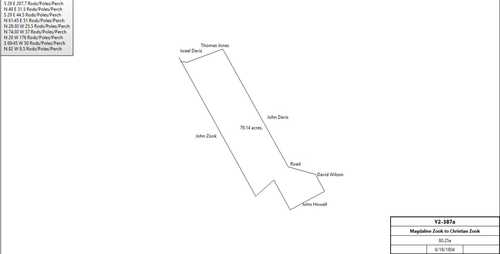
Magdaline Zook |
Christian Zook (senior) |
6/18/1804 |
80¼a, 14¾a,2¾a |
$1,600 |
Y2-387; continued in table C.1.3 |
John Zook & Elizabeth |
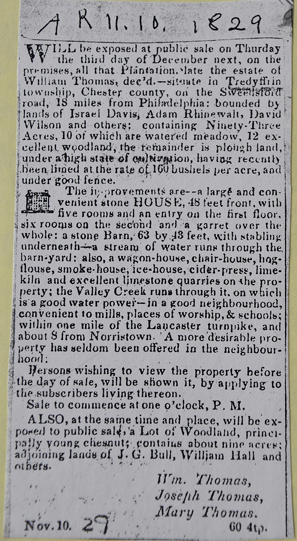
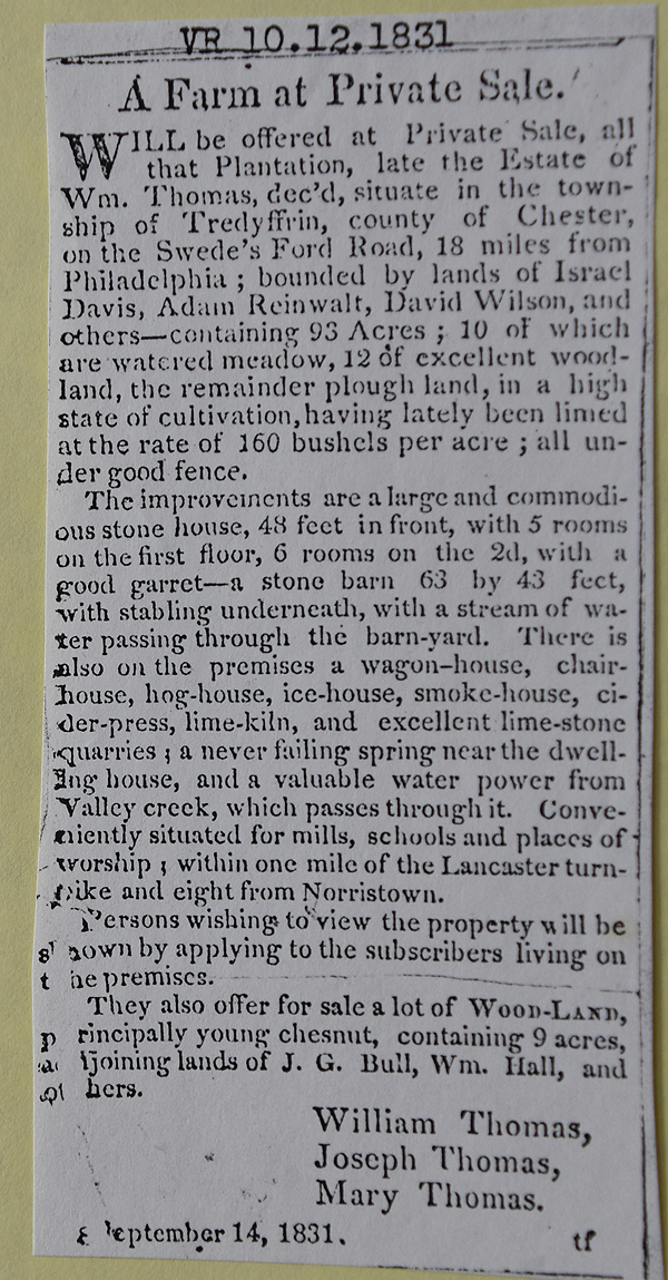
William Thomas |
11/26/1811 |
83a 32p (was 87a) + 7.45a |
$7,276 |
E4-372. two tracts. WILLIAM THOMAS left his mark, his initials with the date 1812 is carved on the mantle over the old colonial fire place |
William Thomas |
Joseph, William, & Mary (children) |
1829 |
|
|
Died. Bequest |
|
|
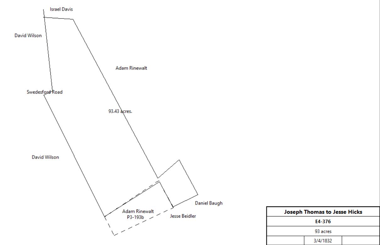
Joseph & Margaret Thomas |
Jesse Hicks |
3/4/1832 |
93a |
$8,111 |
E4-376. Including house |
 |
Jesse G. Hicks |
|
|
|
|
Died |
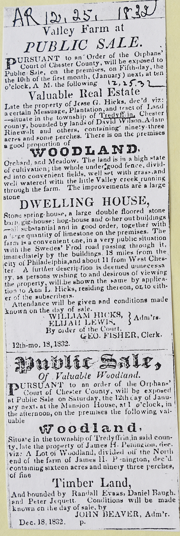 |
Admins. of Jesse Hicks |
Larkin Dutton |
|
93a 37p |
$8,111 |
F4-389 |
Sheriff (land of Larkin Dutton) |
Baldwin Weaver |
2/3/1836 |
93a |
|
K4-462; see table C.1.3 |
|
|
|
|
|
|
|
|
|
|
|
|
Adam Rhinewalt |
|
1800 - 1836 |
|
|
Sue Andrews’ G.G.G. Grandfather |
|
John Morton Davis |
1842 |
|
|
See 'Howeville' by Sue Andrews |
John Morton Davis |
|
1847 |
|
|
died intestate |
William Wally Davis |
|
1865 - 1881 |
|
|
|
William Wally & Cornelia Davis |
Ellwood Jaquette |
4/1/1881 |
69a 20p + 1a |
$8,700 |
K9-521 |
William Wally Davis |
|
1883 |
120a |
|
Breou map |
William Wally & Cornelia Davis |
A. J. Cassatt |
6/29/1886 |
165.25a |
$36,355 |
C10-260 |
Ellwood & Alice Jaquette |
John D. Reed |
3/29/1898 |
69a 20p + 1a |
$8,000 |
T11-65 |
Ellwood Jaquette |
A.J. Cassatt |
1898 |
|
|
See 'Howeville' by Sue Andrews; deed not found |
John D. Reed |
|
1912 |
69a 20p |
|
Atlas |
Eleanor B. S. Cassatt |
|
1933 |
702a |
|
Atlas |
|
|
FREDRICK HOUSEMAN being so seized died and letters of Admr. granted 3/12/1800 in Admr. docket 2 page 450 to Devault Beaver, John Davis. Heirs: widow,-Frederick, Catherine (m. Devault Wanner) Elizabeth (m. Henry Baugh), Susanna (m. George Beaver), Sarah (m. Francis O'Neil), Mary (m. Samuel Rossiter), Christian, Marshall, Daniel & John.
5/22/1800 Petition setting forth above facts and asking appointment of inquest to make partition of tract of 190 acres in Tredyffrin Twp., and also lot of 5 acres. Whereupon the Court awards said inquest.
6/17/1800 Return of inquest appraising said real estate as follows:
Tract #1 at £3621 3 s 6 p.
Tract #2 at £43 8 s 9 p. which return is confirmed.
Agreement of all heirs filed that George Beaver son-in-law of decedent may accept same at the appraisment whereupon 3/17/1801 said lands are adjudged to GEORGE BEAVER, he giving security. Same day with Devault Beaver and John Davis as surety who are approved. O.C.D. #10 pages 195 $ 244
E4-376 JOSEPH THOMAS & MARGARET, ux WILLIAM THOMAS & MARY by deed dated 3/14/1832, recorded 3/14/32 in E. 4-77-376 conveyed to JESSE G. HICKS certain tract in Tredyffrin Twp., as described in item (23) containing 93 acres 37 per. And also privilege of a road one pole wide along the said Israel Davis' line to cross the Valley creek for a watering place for creatures from the land then of Christian Zook. Being the same which John Zook & ux deed in E.4-372 conveyed to William Thomas in item (19) and deed in E.4-372 on item (..) and John Zook et al by release in E 4-74-374 confirmed unto William Thomas.
JESSE HICKS being so siezed and letters of Admr. granted 12/8/1832 in Admr. Doc 4-257 to William Hicks 2/8/1832 Petition of said Admrs. setting forth above facts and that personal estate of decedent is insufficient for the payment of debts and that he died seized inter alia of messuage and tract of land in Tredyffrin Twp., containing 93 acres and praying the Court to grant an order of sale of said real estate, whereupon the court grants said order of sale. Bond to be filed in sum of $14,000 2/4/1833 Return to said order of sale that premised had been sold to Larkin Dutton for $87 per acre, amounting to $8111.11 which sale is confirmed by the court. O.C.D. 16 pages 215 & 237
F4-389 WILLIAM HICKS & ELIJAH KEWIS, Admrs. of Jesse Hicks by deed dated 3/14/1833, recorded 3/14/1833 in F.4-78-389 conveyed unto LARKIN DUTTON messuage and tract in Tredyffrin BEGINNING at a stake in a corner of David Wilson's land and in a line of Israel Davis' land; thence by lines of land S 861/4 E 33 to a stake a corner of Adam Rinewalt's land; thence by lines of the same S 26 E 201.5 to a chestnut tree marked N 49-23 E 311/2 to a stone S 28 441/2 to a stake in a line of Daniel Baugh's land; thence by a line of said Daniel Baugh's and Jesse J. Bidler's land S 64 W 31 to a stone a corner of said Adam Rinewalt's land; thence by lines of the same N 272/3 W 32.1 to a stone. S 571/2 W 72.88 to a stone in a line of Davis Wilson's land; thence by line of the same N 261/2 W 152.15 P. to the middle of the Swedesford Road; thence along the same N 61/4 W 92 to the place of beginning. Containing 93 acres 37 P.
And also privilege of a road one pole wide along the said Israel Davis' line to cross the Valley creek for a watering place for creatures from the northeast corner of said tract through the land late of Christian Zook. Recites deed in E. 4-77-376 in item (21) and death and Orphans Court on estate of Jesse G. Hicks.
|
Table C.1.3
|
From |
To |
Date |
Area |
Cost |
Reference |
|
|
|
|
|
|
Magdaline Zook |
Christian Zook (senior) |
6/18/1804 |
80¼a, 14¾a,2¾a |
|
Y2-387; see deed plans; from table C.1.2 |
 |
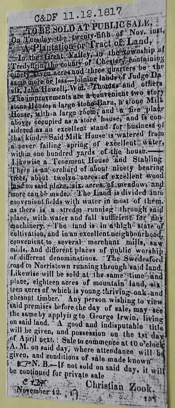
Chester & Delaware Federalist 11/12/1817
See Newspaper clipping in Document database for commentary
|
Heirs of Christian Zook |
Adam Rinewalt |
5/9/1818 |
80a 119p, 12a 92p, 2a 120p |
$10,240 |
P3-193; see deed plans |
Adam Rinewalt |
William C. Brown |
4/1/1836 |
80a 119p, 12a 92p, 2a 120p |
$8742 25c |
L4-411 |
William C. Brown |
Horatio J. Supplee |
4/4/1837 |
80a 119p, 12a 92p, 2a 120p |
$5735 81c |
O4-145 |
Horation & Elizabeth Suplee |
Washington Garner |
3/20/1840 |
13a |
$1,950 |
S4-688 |
Washington & Hannah Garner |
Charles Thompson |
7/17/1747 |
13a |
$2,600 |
D5-598 |
Charles & Margaret Thompson |
Henry J. Evans |
3/29/1855 |
15a |
$7,000 |
Y5-115 |
|
|
|
|
|
|
Horatio J. Supplee |
Baldwin Weaver |
3/20/1840 |
1a 106p, 12a 92p |
$1067 81c |
R4-388 |
Sheriff (land of Larkin Dutton) |
Baldwin Weaver |
2/3/1836 |
93a |
|
K4-462; from table C.1.2 |
|
|
|
|
|
|
Heirs of Baldwin Weaver |
J. Morton Davis and Isaac H. Davis |
3/31/1864 |
107a 38p |
$16,407 34c |
V6-622 |
J. Morton Davis |
Isaac H. Davis |
10/25/1865 |
half part of 107a 32p |
|
Z6-391 |
execs of Isaac H. Davis |
Peter Hartman |
3/28/1874 |
93a, 1a 106p, 12a 92p; totalling 107a 32p |
$12,908 70c |
M8-36 |
Peter Hartman |
|
1883 |
107a 32p |
|
Breou’s Atlas |
 |
|
Table C.2 Alison – Rowland tract
|
From |
To |
Date |
Area |
Cost |
Reference |
|
|
|
|
|
|
Lewis James |
Rev. Frances Alison |
4/4/1753 |
400a |
|
Northern section; southern boundary Valley Creek |
Frances & Hannah Alison |
Lewis James |
4/15/1753 |
400a |
|
Mortgage H-550 |
Lewis James |
John Christie |
2/20/1754 |
250a |
|
See table C.3 for sale of a portion of 250a |
Lewis James |
Frances Alison |
|
150a |
|
|
Jerman Walker |
John Rowland |
4/23/1755 |
73a & ½ mill
Part of 300a of Thomas Jerman |
£476 |
W2-508; see deed plan & table B.1 |
Jerman Walker ux |
John Rowland |
1762 |
½ mill |
|
W2-505 |
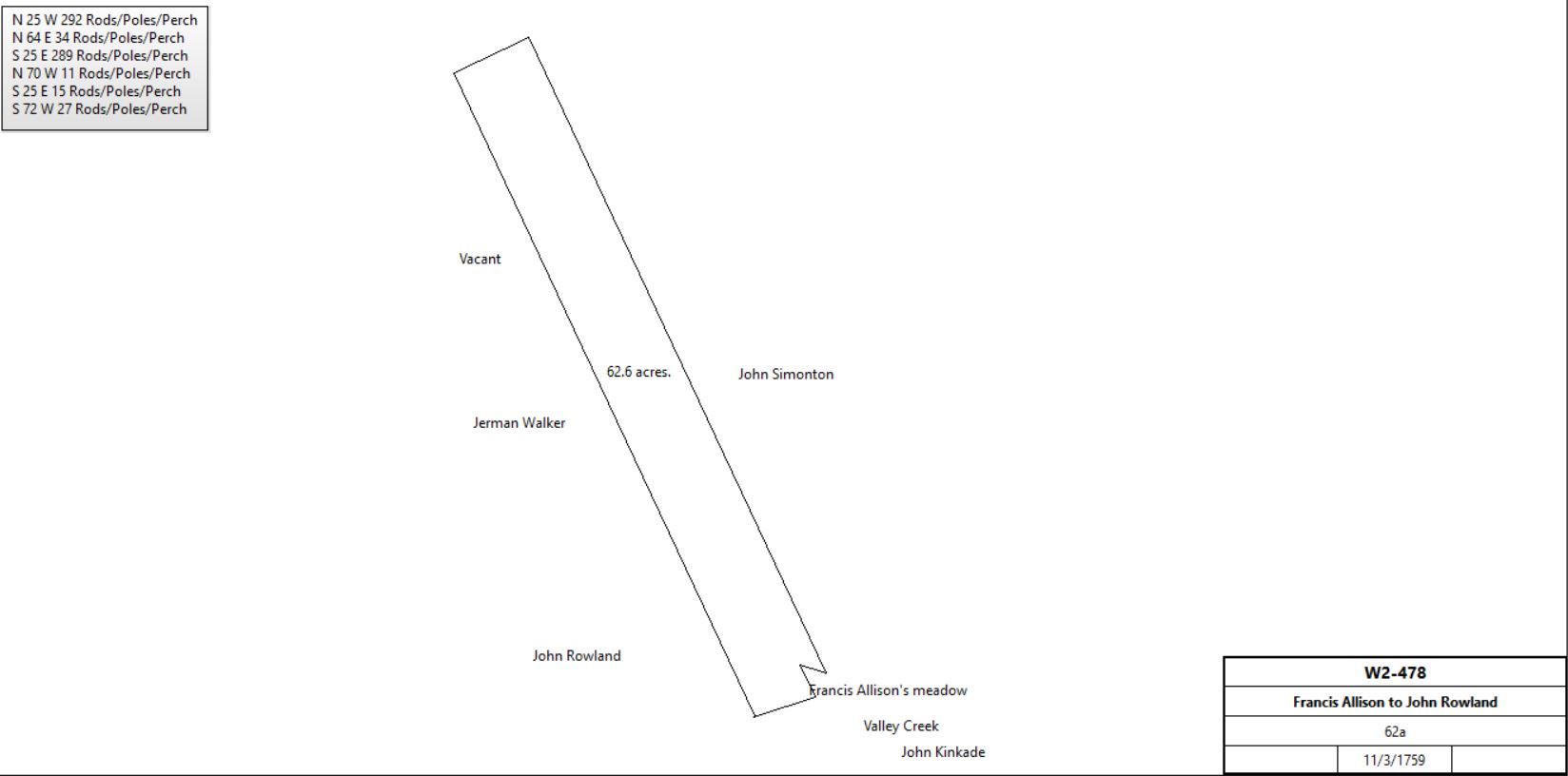
Frances & Hannah Alison |
John Rowland |
11/3/1759 |
62a |
|
W2-478; see deed plan |
 |
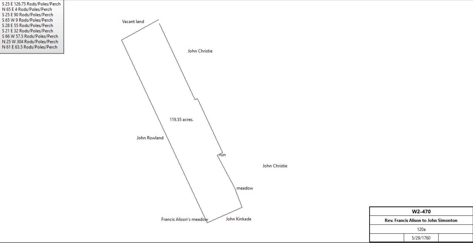
Rev. Francis & Hannah Alison |
John Simonton |
5/29/1760 |
120a |
£310 |
W2-470; see deed plan and table C.2.2 |
 |
Francis Alison |
David Wilson |
10/23/1779 |
1a |
|
Phila. D-3-268; next to Valley Creek |
Francis Alison |
|
|
|
|
Not in Chester County tax returns; no probate record |
John Rowland |
William & Thomas Rowland (sons) |
11/10/1789 |
|
|
Will #9-96 |
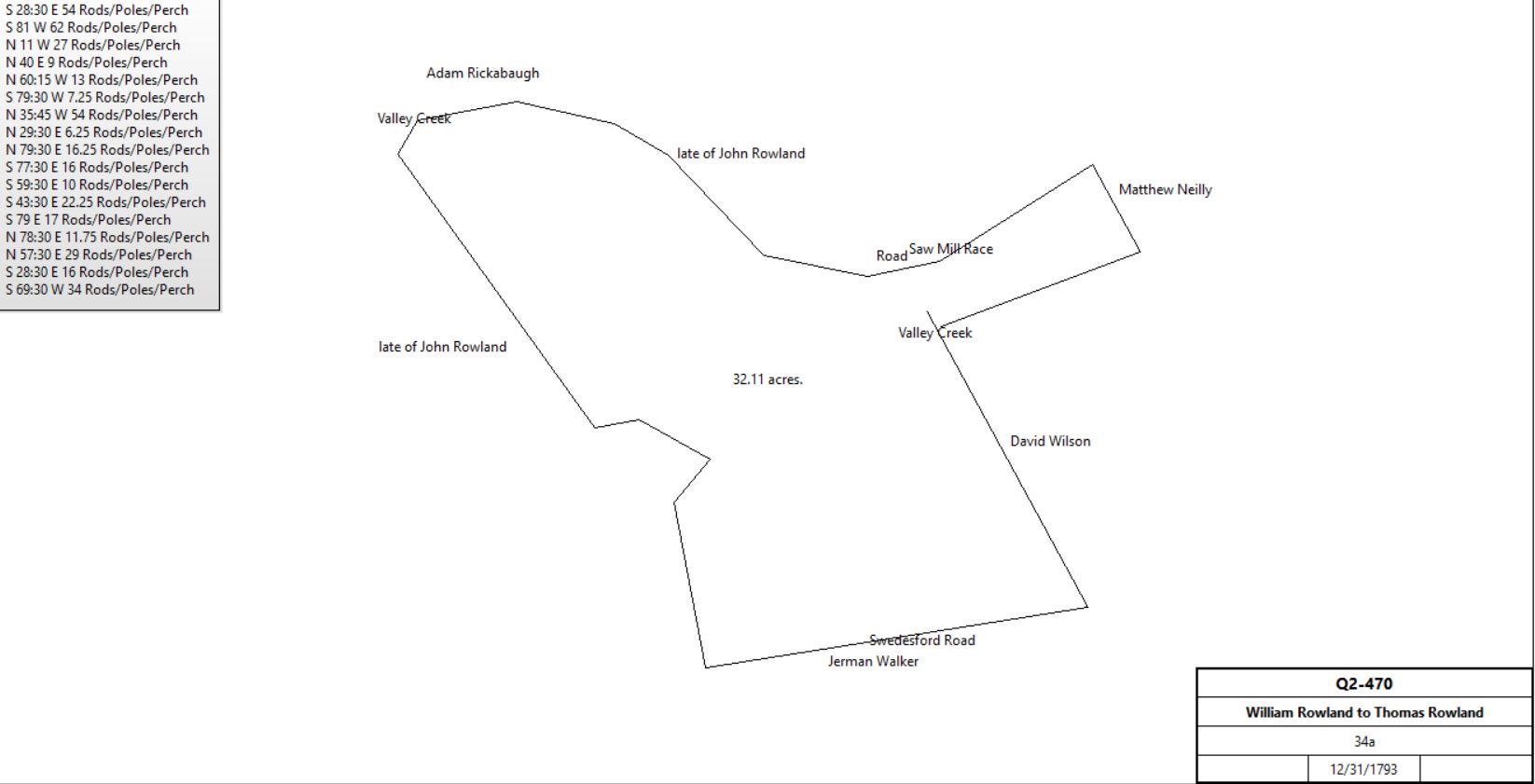
William & Sarah Rowland |
Thomas Rowland |
12/31/1793 |
34a |
5s |
Q2-470 |
 |
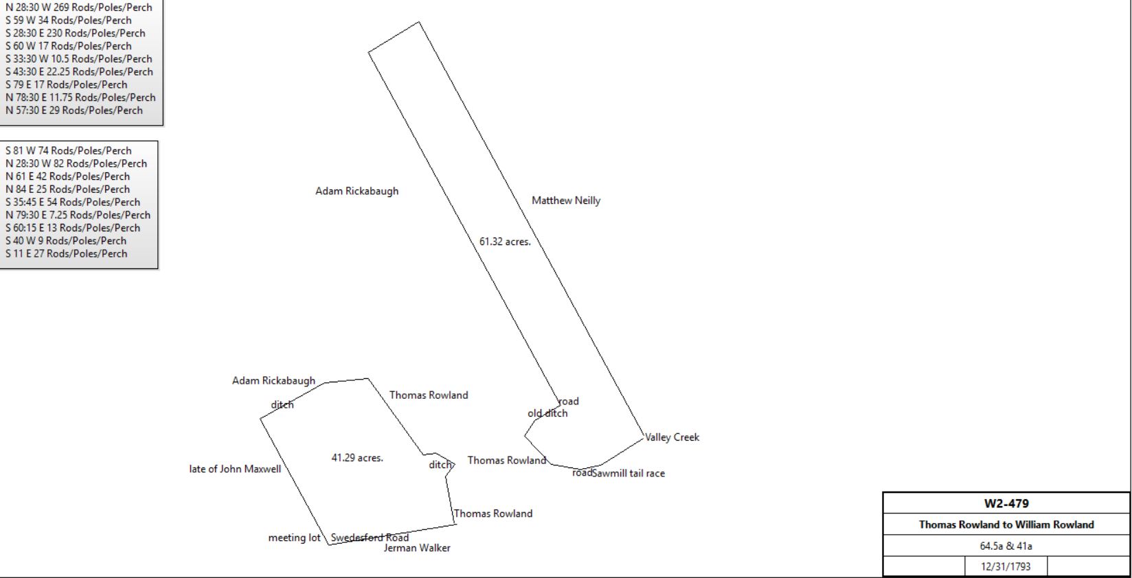
Thomas Rowland |
William Rowland |
12/31/1793 |
64½a & 41a |
5s |
W2-479 |
 |
Thomas Rowland |
|
1798 |
29a |
|
Glass tax; neighbor William Rowland |
William Rowland |
|
1798 |
99a |
|
Glass tax. Stone house 30’ x 20’ 2 stories next to Rickabaugh |
|
William Rowland |
8/21/1801 |
12a |
|
See survey; In right of Francis Allison., warrant dated 2/23/1765 |
William Rowland |
|
1814 |
|
|
Died |
State |
Heirs of William Rowland (Charles, Jonathan and Ann Todd) |
3/3/1817 |
12a |
|
Patent H15-380 |
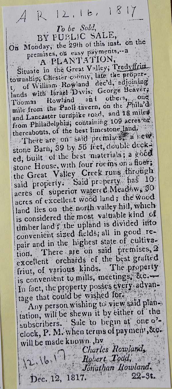
American Republican 12/16/1817
See newspaper clipping in Document database for commentary
|
Heirs of William Rowland (Charles, Jonathan and Ann Todd) |
David Maxwell |
3/30/1818 |
14.75a? |
|
Deed not found |
David & Elizabeth Maxwell |
Thomas Rowland |
3/30/1818 |
13a 150p, 4a 106p, 110p |
$3252 75c |
P3-458; messuage on first plot |
Penn Estate |
Thomas Rowland et al |
8/3/1819 |
12a 56p |
$3 |
P3-461; payment of quit rent and discharge for ever |
|
|
|
|
|
|
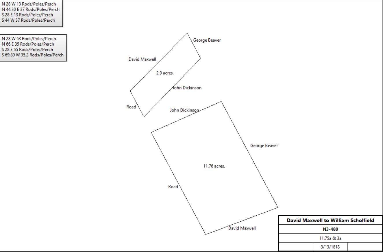
David & Elizabeth Maxwell |
William Scholfield jr. |
3/13/1818 |
11.75a & 3a |
$1,843 75c |
N3-480 |
 |
Admin. of David Maxwell (Robert J. Evans & William Harris) |
William Scholfield |
5/24/1819 |
|
|
R3-199 |
John Dickinson |
William Scholfield |
12/6/1822 |
|
|
U3-520 |
Marple Courson |
William Scholfield |
1/30/1839 |
|
|
R4-249 |
Marple Couson |
William Scholfield |
4/5/1839 |
|
|
V4-128 |
Marple Couson |
James Latta |
2/5/1839 |
2a 126p |
|
Deed poll |
Ex. Of James Latta (Lydia D. Latta) |
William Scholfield |
4/16/1842 |
2a 126p |
$116 |
V4-558 |
David Ducenkey(?) |
William Scholfield |
4/1/1844 |
|
|
A5-20 |
Samuel Dickinson |
William Scholfield |
2/23/1849 |
|
|
H5-431 |
William Scholfield |
|
5/11/1871 |
|
|
Will |
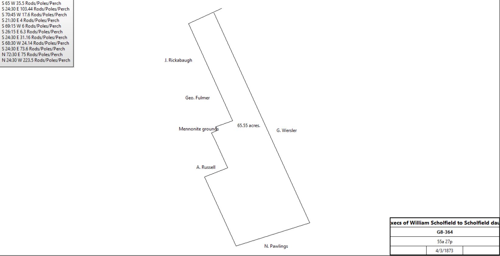
Nathan Whatters & Jacob Beidler, Execs of William Scholfield |
Mary E. Snyder & Elizabeth & Hannah Scholfield |
4/3/1873 |
55a 27p |
$6550 |
G8-364 |
 |
|
|
|
|
Table C.2.1 Second Great Valley Mill
|
From |
To |
Date |
Area |
Cost |
Reference |
|
|
|
|
|
|
Frances Alison |
John Wilson |
10/23/1779 |
1a? |
|
Phila. D-3-268 |
John Wilson |
John Rowland |
11/10/1779 |
1a |
£120 |
W2-506. New mill built east side of North Valley Road |
 |
John Rowland |
Thomas Rowland |
11/10/1789 |
|
|
Bequest |
William & Sarah Rowland |
Thomas Rowland |
12/30/1793 |
79a 31p |
|
L2-470 |
Thomas Rowland |
|
1798 |
|
|
Glass tax: Stone grist Mill 30 x 18, saw mill on 29a |
William & Sarah Rowland |
Thomas Rowland |
11/8/1802 |
6a 28p |
£20 |
P3-460 |
David & Elizabeth Llewelyn |
Thomas Rowland |
3/30/1805 |
6+a |
£150 9s 4d |
Z2-283 |
Thomas J. & Elizabeth Walker |
Thomas Rowland |
4/1/1811 |
16a |
£480 |
G3-48 |
David & Elizabeth Maxwell |
Thomas Rowland |
3/13/1818 |
13+ & 4+a
|
$3,252 75c |
P3-458 |
Thomas Rowland |
|
1837 |
|
|
Died (will) |
Benjamin Rowland, exec of Thomas Rowland |
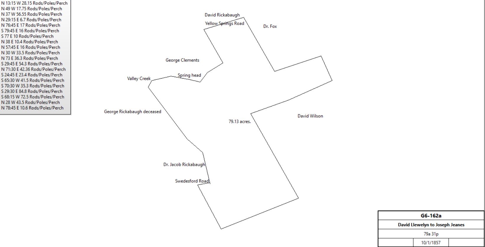
David Llewelyn |
4/1/1856 |
79a 31p, 7a 150p, 6a 28p |
$11,385 |
C6-81; mill. Smallest tract north boundary Bilton Line. |
David Llewelyn |
Joseph E. Jeanes |
10/1/1857 |
79a 31p, 7a 150p, 6a 28p |
$11,500 |
G6-162 |
 |
Joseph E. Jeanes |
|
1883 |
92a |
|
Breou |
Joseph E. Jeanes |
Charles Lyman |
3/31/1886 |
17a 140p, part of 79a 31p |
$3306 87c |
C10-147 |
Joseph E. Jeanes |
John Ulmann |
1887? |
13a 8p & 22a 152p part of G6-162 |
$9000 |
G10-86 |
Joseph E. Jeanes |
John Ulmann |
5/11/1887 |
2a 84p part of G6-162 |
$440 36c |
G10-87 |
Joseph E. Jeanes |
Josiah Kolb |
9/1/1887 |
7a 150p one tract of G6-162 |
$476 |
U10-11 |
Joseph E. Jeanes |
Hannah B. Jeanes, wife |
1891 |
|
|
Died; will |
Hannah B. Jeanes |
Alfred Hoopes, brother; Jacob B. & John G. Hoopes, nephews; Sidney Hasrar?, neice |
|
|
|
Died intestate |
Alfred Hoopes et al |
Sarah Whitworth |
28/12/1901 |
35a 135p & 6a 28p part of G6-162 |
$5250 |
F12-102 |
Sarah Whitworth |
|
1912 |
35a |
|
Atlas |
David Witworth |
Richard Houghton |
1913 |
|
|
Burns |
Marie Haughton |
|
1950 & 1963 |
28.6a |
|
Atlas, Great Valley Mill |
|
W. Thomas Kelly |
1972 |
|
|
|
W. Thomas Kelly |
|
1995 |
|
|
|
|
|
W2-506 Beginning in the corner of John Rowland’s land in the middle of Valley Creek and in the line of land of Matthew Neiley and extending thence up said creek and by land of said John Rowland 11p, and thence by said Rowland’s land S25°E 15p to a corner Spanish oak in the line of land of David Wilson, then by Wilson’s land S75°W 11p to a corner of Neiley’s land, thence by same N25°W 15p to the place of beginning.
This description seems to have Valley Creek placed incorrectly. It should be on David Wilson’s boundary.
|
|
Table C.2.2 – Matthew Neely tract
|
From |
To |
Date |
Area |
Cost |
Reference |
|
|
|
|
|
|
Rev. Francis Allison |
John Simonton |
5/9/1760 |
120a |
|
W2-470; see deed plan above |
John Simonton |
|
1760 |
120a |
|
First entry in tax records |
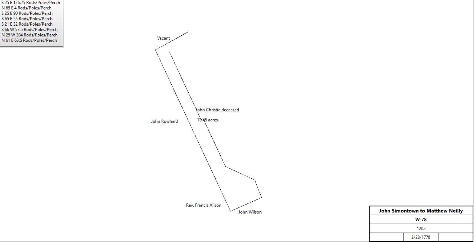
Rev. John & Jane Simonton |
Matthew Neely |
2/28/1778 |
120a |
£1700 |
W-78 |
 |
Matthew Neely |
Rev. John Simonton |
1778 |
120a |
|
Mortgage A-426. Satisfied 1787 |
Matthew Neely |
|
1794 or earlier |
|
|
Estate #4397. Letters of administration granted 10/29/1794 |
Estate of Matthew Neely |
|
1798 |
119a |
|
Glass tax |
Penn |
Robert Todd & David Wilson (in trust for 5 Neely minors) |
8/1/1801 |
24a 14p |
£35 16s 3d |
W2-471; Along Welsh line, at top of hill; see patent plan. In right of Francis Alison |
Commonwealth of Pennsylvania |
Martha Neily et al & Samuel Sloan |
4/3/1803
5/25/1785 Warrant |
13a 38p |
|
Patent #51-58. Between Neely tract & 24a 14p; see patent plan |
Robert Todd & David Wilson |
Martha Neily et al & Samuel Sloan |
5/16/1803 |
|
|
W2-273 Release |
Martha Neiley & other Neiley children |
David Lewellyn |
5/10/1803 |
167a 130p (156a + 13a) |
£2895 |
W2-474 |
John Davis & Elizabeth Llewelyn, execs. of David Llewelyn |
George Beaver |
4/5/1813 |
116a, part of 167a 130p |
$10,353 |
Y4-358 |
Samuel Beaver |
|
|
|
|
Survey of George Beaver’s land |
George Beaver |
David Ruth et al |
Donated c. 1817; lease 1819 |
|
|
R3-117; Donated land for Diamond Rock schoolhouse on 999 year lease |
David Llewelyn Beaver & George Robinson Beaver, execs. of George Beaver |
George Wersler (son-in-law of George Beaver) |
3/4/1869 |
117a 34p |
$334 75c per year to Ann Beaver, widow. On her death $5079 20c to children of George & Ann |
S7-144 |
George Wersler |
|
1883 |
117a |
|
Breou |
George Wersler |
|
1933 |
117a |
|
Atlas |
William Almy |
|
1950 |
64.5a |
|
Atlas; both sides of the Turnpike |
Gertrude & William Almy |
George & Margaret Connally |
4/17/1953 |
18.719a |
|
I25-65 |
|
|
Patent #51-58 Patent dated April 3, 1803 enrolled 5/4/1803 Patent Book P, vol. 51 page 58,- Know ye that in consideration of the moneys paid by Francis Allison unto the late Proprietaries at the grant of a warrant hereinafter mentioned, and of the sum of |$26.36 lawful money now paid by Martha Neilly and Samuel Sloan unto the Receiver General of this Commonwealth, there is granted by said Commonwealth unto the said Martha Neilly and Samuel Sloan a certain tract of land called New Garden situate in Tredyffrin Township, Chester County, BEGINNING At a corner; thence by land of John Rowland SSE 65.7 perches to a post; thence by land of Matthew Neilly N66°E 65 perches to a post; thence by land of Sarah Christy NNW 45 perches to a post thence by a larger tract of which this is a part WSW 12 perches to a white oak, SSE 20 perches to a stone, WSW 48 perches to a black oak, NNW 26 perches to a chestnut, and WSW 5 perches to beginning.
Containing 13 acres 38 perches. Which said tract is part of a larger tract which was surveyed in pursuance of warrant dated 1-23-1765 granted to the said Francis Allison, whose right to the above described tract by virtue of sundry conveyances and assurances in the law became vested in the said Martha Neilly and Samuel Sloan, and it appearing that survey of the meane conveyance was informal, whereupon the Board of property by minuted of the Board of the 2nd inst. ordered a patent issued to the said Maitha Neilly and Samuel Sloan, etc.
W2-474 Beginning at a post and stones, a corner of land of David Wilson and Thomas Rowland; thence by said Rowland’s land N27¾°W 422.1 perches to a gum grubb; thence by land of Adam Ricabaugh and other land of the said Martha Neiley and Samuel Sloan N73½°E 64.7 perches to a heap of stones; thence by land of Israel Davis the following 6 courses and distances: S28¼°E ? to a heap of stones; N62°E 4 perches to a heap of stones. S27½°E 92.1 perches to a walnut tree, S62°W 9 perches to a rock in the run; S31°E 56 perches to a post, and S? to a walnut grubb, thence by land of said David Wilson S67? To the place of beginning.
|
Table C.2.3 – Crossroads School
|
From |
To |
Date |
Area |
Cost |
Reference |
|
|
|
|
|
|
Excr. of William Schofield (Israel Beidler) |
Mary E. Snyder, Elizabeth L. & Hannah B. Schofield |
4/3/1873 |
55a 27p |
$6550 |
G8-364; combination of 8 deeds |
Elizabeth L. & Hannah B. Schofield, Isaiah F. & Mary E. Snyder |
Nathan Pawlings |
4/2/1879 |
34a 53p, part of G8-364 |
$5100 |
D9(201) - 23 |
Nathan Pawlings |
|
1883 |
34a |
|
Breou |
Nathan Pawling |
|
4/5/1890 |
|
|
Will proved, written 2/24/1875 |
Morgan & S, Annie Pawling |
Jacob S. Acker |
1/1/1898 |
|
$3045.47 |
Q11-198 |
Jacob S. & Susanna H. Acker |
Joseph Brown |
3/5/1898 |
|
$3,200 |
Q11-234 |
Susanna S. Brown et al (heirs of Joseph Brown) |
Deborah N. Bishop |
4/3/1899 |
|
$3,000 |
X11-172 |
Philip S. & Deborah N. Bishop |
Caroline F. Clemens |
4/1/1901 |
34a 53p |
$4,000 |
H12-109 |
Caroline F. Clemens |
Martha Armstrong |
10/19/1903 |
34a 53p |
$3,500 |
O12-281 |
Martha E. & Robert H. Armstrong |
Pennsylvania Industrial School |
9/26/1904 |
34a 53p |
$300 + mortgages |
U12-235; messuage & farm |
Trustees of Pennsylvania Industrial School |
Mary E. Webb |
6/6/1910 |
34a 53p |
$7000 |
Z13-188 |
W.J. Fields et al (Trustees of Pennsylvania Industrial School) |
Mary E. Webb |
6/30/1910 |
none |
$1 |
W13-530; water rights |
Mary E. Webb |
Grace L. Wedge |
8/20/1910 |
34a 53p |
$1 |
A14-116 |
Grace L. Wedge |
|
1912 |
35a |
|
Atlas |
Grace L. Wedge |
|
1933 |
34a + 53a |
|
Atlas; Roseway Farms |
|
Table C.3 Christie tract
|
From |
To |
Date |
Area |
Cost |
Reference |
|
|
|
|
|
|
Lewis James through attorney William Griffith |
John Christie |
2/20/1754 |
250a |
|
Bounded by lands of Matthew Neely, Frederick Houseman, & Adam Siter. John Christie owned 200 acres in Tredyffrin in 1760 tax |
John & Sarah Christie |
Francis Allison |
9/1/1756 |
24a 36p & 7a 78p (part of 250a) |
£67 7s 9d |
W2-466 |
John Christie |
Sarah (wife), John & David Christie (sons) |
|
|
|
Will; no will or administration in Chester County. Tax records suggest death between 1762 and 1765. |
Penn |
Francis Alison |
2/23/1765 |
50a |
|
Warrant A-37 |
Penn |
Francis Alison |
Not dated |
56a 78p |
|
Survey B11-122 |
Penn |
Sarah Christie |
5/25/1785 (survey) |
31¼a + 29a 120p |
|
See Survey Plan B8-240. In right of Francis Allison |
Penn |
Sarah Christie |
4/4/1787 |
31¼a |
|
Patent P16-447; South of previous plot |
Sarah Christie |
|
1778 |
200a |
|
Tax |
Sarah Christie |
|
Before 1799 |
|
|
Died |
David Christie |
|
1798 |
100a |
|
Glass tax, rented |
John Christie |
|
1798 |
100a |
|
Glass tax, stone house 30’ x 26’ |
John & David Christie |
Caleb North, Charles Jolly, and Robert Porter |
1/25/1799
2/21/1799 |
|
|
Q2-430 or Q2-429
Q2-420 |
Penn |
Caleb North, Charles Jolly, & Robert Porter |
3/24/1800 |
29a 120p |
£42 8s 7d |
S2-280 Bounded by lands of Matthew Neely, township line. See deed plan, same description as survey. No patent found. |
Caleb North, Charles Jolly, and Robert Porter |
John Christie |
3/29/1800 |
250a +29a 120p |
$1 |
S2-318a |
John Christie |
Israel Davis of East Whiteland, merchant |
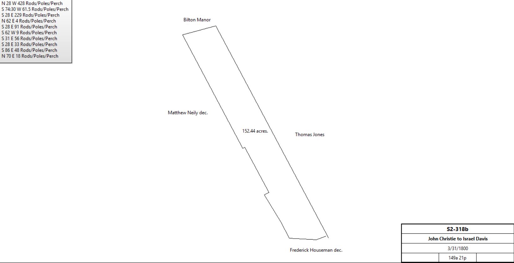
3/31/1800 |
149a 21p |
$6,860 |
S2-318b; see deed plan |
 |
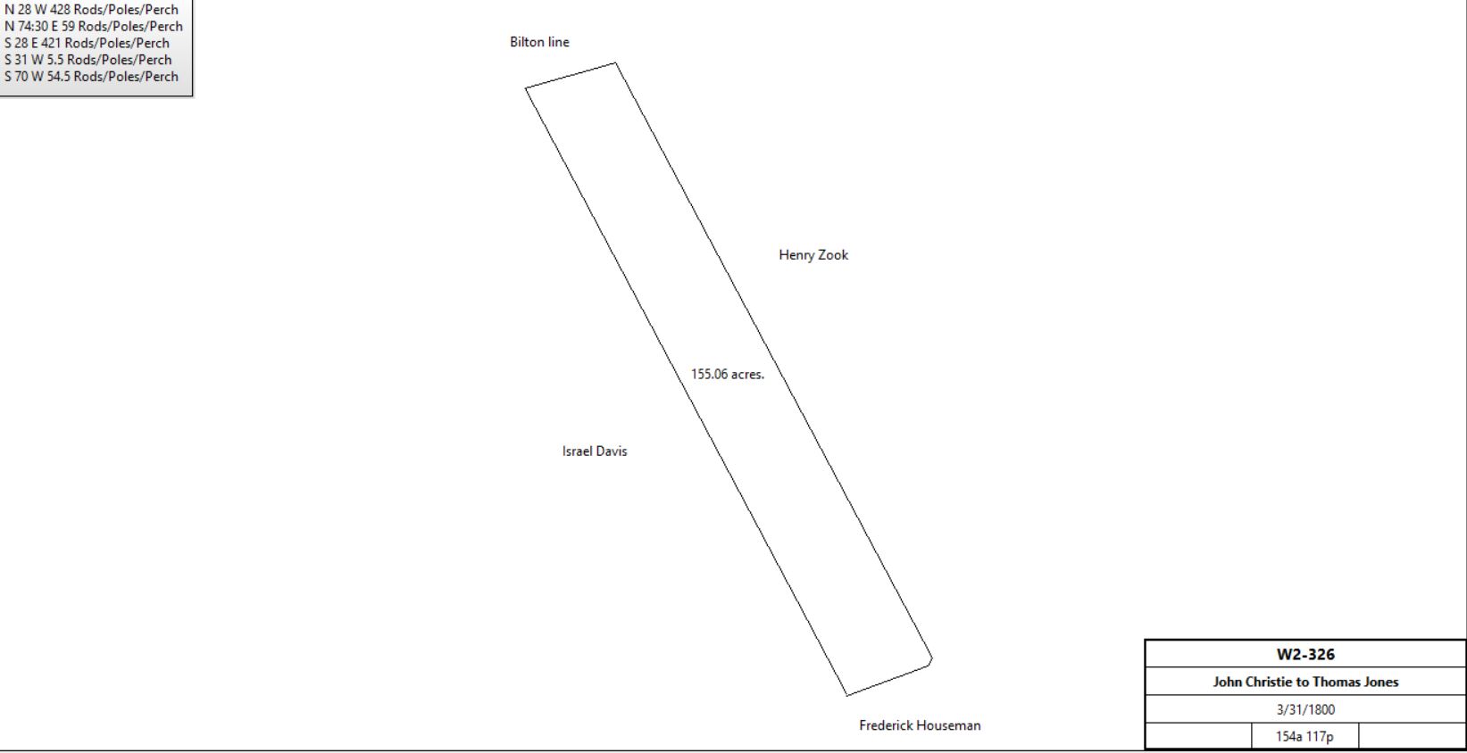
John Christie |
Thomas Jones |
3/31/1800 |
154a 117p |
$5570 35c |
W2-326; see deed plan |
 |
Thomas & Mary Jones |
Devault Beaver |
1807 |
29a 2r 25p |
$1777.50 |
A3-444, part of W2-326 |
Thomas Jones & Mary, his wife |
Jacob Beitler |
4/11/1807 |
125a 12p |
£2501 10s |
B3-28 |
|
|
W2-466 #1: Beginning at a stake in the line of John Kinkead’s land, thence N60ºE by the same land 18p to a black oak, thence N25ºW by John Christie’s land 32p to a post in the meadow, thence N28ºW by John Christie’s land 55p to a rock in a small run, thence N65ºE by the same land 9p to a walnut sapling, thence N25ºW by same land 90p to a heap of stones, thence S65ºW by said John Christie’s land and the other land of Francis Allison 26p to a hickory, thence S25ºE by Francis Allison’s other land 180 1/3p to the place of beginning. 24a 36p
#2: Beginning at a post in the line of vacant land, it being a corner of Francis Allison’s other land, thence S25ºE by Francis Allison’s land 54p to a black oak, thence N65ºE by same land 22p to a white oak, thence N25ºW by John Christie’s land 55p to a post, thence S61ºW by vacant land 22p to the place of beginning. 7a 78p
A3-444 Beginning at a stone near Valley Creek, a corner between this and Israel Davis’ land, thence by same N28ºW 85.9 perches to a stone thence N74½ºE 58.6 perches to a stone, thence by grantee S28ºE 77.3 perches by the edge of aforesaid creek, thence crossing said creek S31ºW 5.5 perches to a Spanish oak, thence S70ºW 52.2 perches to the place of beginning.
#1 Beginning at a post near the line of other land of David Howell and Weaver, thence S55°W 13p to a post in the meadow, thence S27°E 207p to a post for a corner in the line of William Sharp’s land, thence S87°E 15p by Sharp’s land to a stone being a corner, thence N27°W 216p to the place of beginning. Containing 19a
B3-28 Beginning at a stone in the corner of the Devault Beaver, in the line of Israel Davis, and by the same N28ºW 342.1 perches to a post in the Bilton line, and along the same N74½ºE 59 perches to a heap of stones, and by the lands of Henry Zook S28ºE 342.1 perches to a corner of Devault Beaver, thence by land of same S74½ºW 58.6 perches to the beginning.
|
|
Table C.3.1
|
From |
To |
Date |
Area |
Cost |
Reference |
|
|
|
|
|
|
Jacob Beitler |
Abraham Bond, John S. Workizer & Ann H., his wife |
4/17/1855 |
6a 104p |
|
|
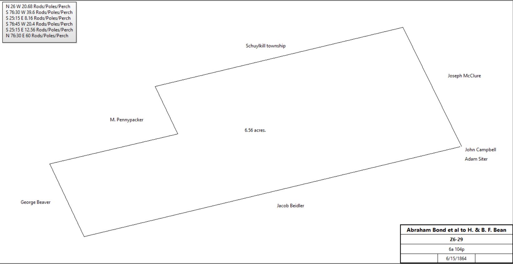
Abraham Bond, John S. Workizer & Ann H., his wife |
H. & B.F. Bean |
6/15/1864 |
6a 104p |
$45 |
Z6-29 |
 |
Mary Jane Bean |
Berwyn Water Company |
12/19/1895 |
4.411a |
$882 20c |
M11-96; part of K11-92 |
 |
|
|
Table C.3.2
|
From |
To |
Date |
Area |
Cost |
Reference |
|
|
|
|
|
|
Jacob & Frances Beidler |
Isaac Beidler |
1/21/1849 |
19a 127p |
|
H5-373, part of B3-28 |
Execs of Isaac Beidler |
John Groff |
3/30/1877 |
3a 55p |
$80.25 |
Not recorded |
Execs of Isaac Beidler |
E. B. English |
|
6a 110p |
$233.78 |
See table E.2 for sale |
John Groff |
|
1883 |
60a 1r 32p |
|
Breou’s Atlas |
John Groff |
Wife in her lifetime, then children |
8/1/1885 probate |
|
|
Will dated 3/19/1883; died 7/19/1885 |
Execs of John Groff |
Hilborn D. Rennard |
2/23/1907 |
3a 55p (also 60a 62p & 21a 73p) |
|
A13-371 |
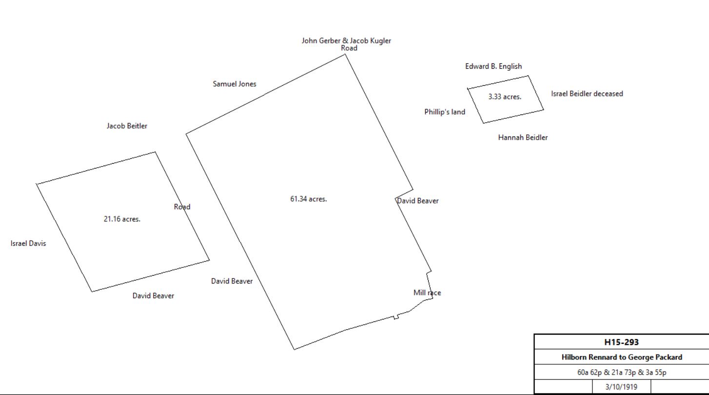
Hilborn D. Rennard |
George R. Packard & Richard Haughton |
3/10/1919 |
60a 62p, 21a 73p & 3a 55p |
$1 |
H15-293 |
 |
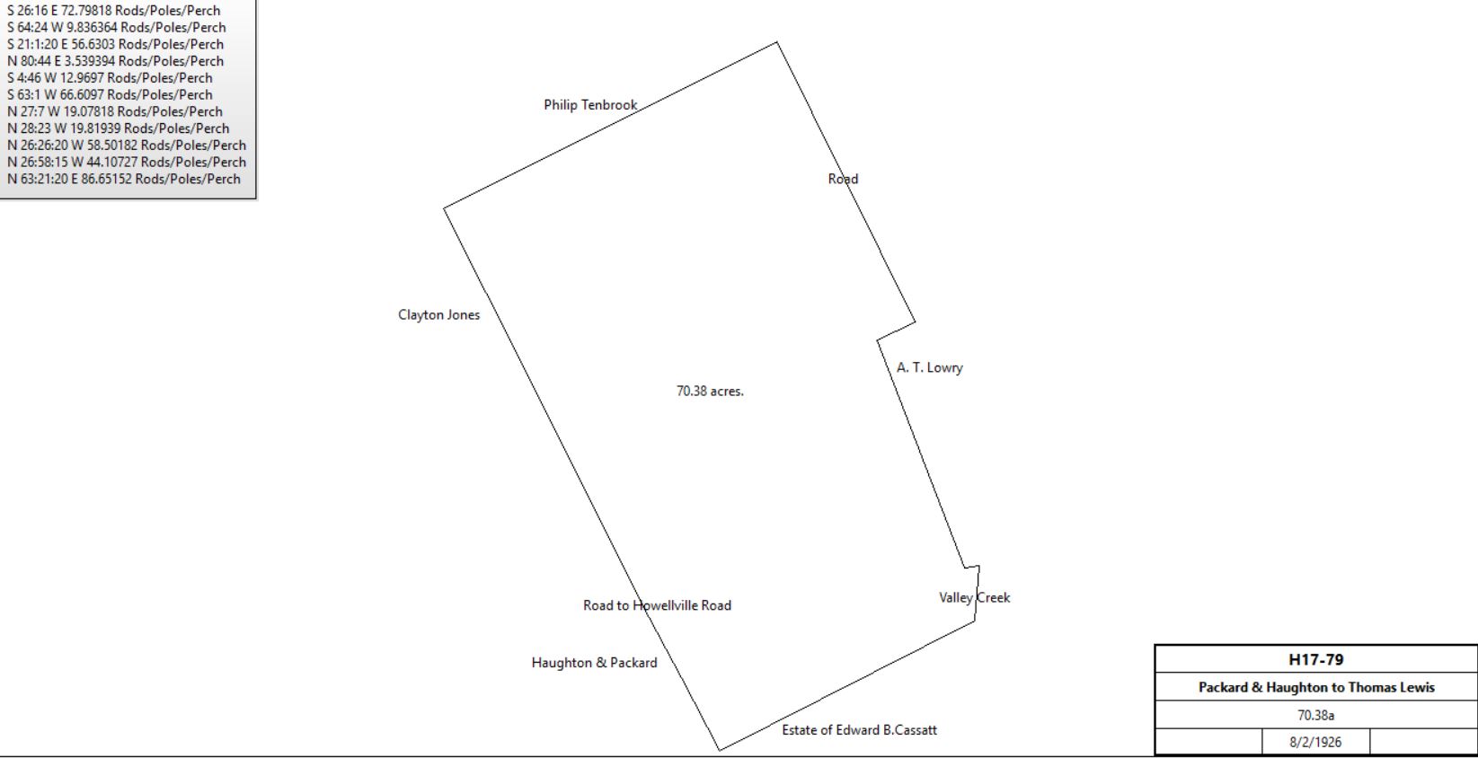
George R. Packard & Richard Haughton |
|
8/2/1926 |
Part of H15-293 |
|
H17-79 |
 |
Thomas H. Lewis |
Richard Haughton |
|
|
|
H17-81 |
Richard Haughton |
Thomas H. Lewis |
|
|
|
H17-84 With restrictions on use for 49 years |
|
|
H5-373 Beginning at a stake in the line of Israel Davis, thence by same N25½°W 54.3 perches, thence by Jacob Beidler N76½°E 59.6 perches to a stone in the line of Jacob Beidler, and by Adam Sitler and Samuel Beaver jr., S25¼°E 54.3 perches, thence by Jacob Beidler S76½°W 59.6 perches to the place of beginning.
|
Table C.3.3 Israel Davis tracts
|
From |
To |
Date |
Area |
Cost |
Reference |
|
|
|
|
|
|
Robert T. & Randel Evans, execs of Israel Davis |
Joseph Batt |
3/15/1833 |
4a 20p |
$272 25c |
G4-134; Wood lot #8 |
Execs of Israel Davis |
Adam Siter |
4/5/1833 |
128a 157p |
$10,382 97c |
G4-189; see table C.3.3.3 |
Execs of Israel Davis |
Joseph Watson |
4/5/1833 |
23a 149p |
$1,715 33c |
G4-192 |
Execs of Israel Davis |
William Scholfield |
3/15/1833 |
3a 155p |
$259 95c |
G4-193 |
Execs of Israel Davis |
Thomas Rowland |
3/15/1833 |
7a 150p? |
$518 95c |
G4-195 |
Execs of Israel Davis |
Abraham & Joseph Beidler |
3/15/1833 |
7a 152.5p |
$504 84c |
G4-196 |
|
Table C.3.3.1 Woodlot next to Welsh line
|
From |
To |
Date |
Area |
Cost |
Reference |
|
|
|
|
|
|
Robert T. & Randel Evans, execs of Israel Davis |
Joseph Batt |
3/15/1833 |
4a 20p |
$272 25c |
G4-134; Wood lot #8 |
Joseph & Cidney Batt |
Penn Mining & Smelting Company |
7/6/1854 |
4a 20p |
$300 |
V5-537 |
Penn Mining & Smelting Company |
Benjamin Skein |
11/1/1855 |
4a 20p |
$186 65c |
A6-447 |
Benjamin Skein |
Nicholas Bean |
3/13/1856 |
4a 20p |
$209 |
B6-449 |
Execs. of Nicholas Bean |
Alfred U. Bean |
12/23/1878 |
4a 20p |
$303 18c |
F9-224 |
|
Table C.3.3.2 Watson / Walters farm
|
From |
To |
Date |
Area |
Cost |
Reference |
|
|
|
|
|
|
Execs of Israel Davis |
Joseph Watson |
4/5/1833 |
23a 149p |
$1,715 33c |
G4-192 |
Joseph Watson |
|
1837 |
|
|
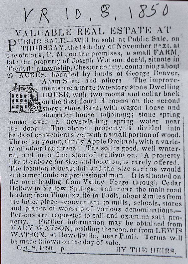
died intestate |
Joseph Watson Administration Abstract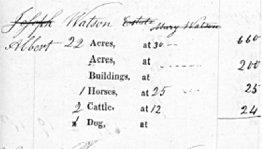
Watson taxes, 1838
|
|
|
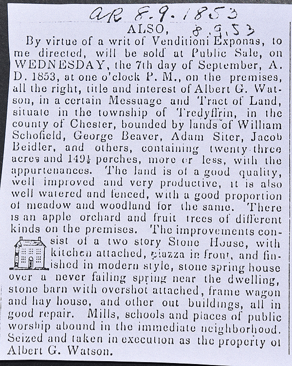
Mary Watson (widow), Lewis & Sarah Watson, Albert G. & Ann Watson, James & Abigail Watson, Elijah & Harriett Watson, Joseph Davis, Albert, John, & Rebecca Watson, Ann (nee Watson) & Charles Holland |
Nathan Walters |
4/5/1853 |
23a 149.5p |
$2,250 |
T5-177 |
Nathan Walters |
|
1871 |
23a |
|
tax return |
William & Clara Miller |
Nathan Walters |
3/29/1879 |
9a 152p |
$1,300 |
D9-13 |
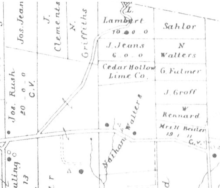
Breou’s atlas extract, 1883
|
Nathan Walters |
|
1900 |
30a |
|
tax return |
Nathan Walters |
Mary Kauffman |
3/31/1906 |
|
|
B13-227 |
Mary Kauffman |
Ellen S. John |
10/2/1907 |
23a 149.5p + 9a 142p |
$3,250 |
A13-569 |
Nathan Walters |
|
1908 |
|
|
Died intestate in Phoenixville |
Ellen S. John |
|
1912 |
35a |
|
atlas |
Ellen S. John |
B. H. Leboutillier |
3/16/1916 |
30a |
$1 |
B15-10 |
B. H. LeBoutillier |
|
1933 |
12a |
|
atlas |
F. B. Wildman jr. |
|
1950 |
12a |
|
atlas |
|
Table C.3.3.3 tract on north side of Yellow Springs Road
|
From |
To |
Date |
Area |
Cost |
Reference |
|
|
|
|
|
|
Robert T. & Randel Evans, Execs of Israel Davis |
Adam Siter |
4/5/1833 |
128a 157p |
$10,382 97c |
G4-189; see table C.3.3 for earlier history. |
Adam & Charlotte Siter |
George Fox |
4/1/1854 |
119a 5p |
$18,000 |
W5-506 |
George & Sarah Fox |
Henry Rennard |
3/26/1858 |
119a 5p |
$15,400 |
H6-252 |

|
Adam & Charlotte Siter |
Nathan Pawling |
3/25/1854 |
9a 152p |
$646 75c |
V5-176 |
Nathan & Mary Jane Pawling |
Thomas Gay |
3/24/1855 |
9a 152p |
$810 |
Y5-118; no messuage mentioned |
Thomas & Ann Gay |
Charles Holland |
3/23/1858 |
9a 152p |
$875 |
H6-493; messuage |
Charles & Rebecca Holland |
Lewis Cornog |
4/1/1865 |
9a 152p |
$1,500 |
Z6-171 |
Lewis & Eliza Cornog |
John M. Beaver |
4/12/1869 |
9a 152p |
$1,500 |
Q7-234; messuage |
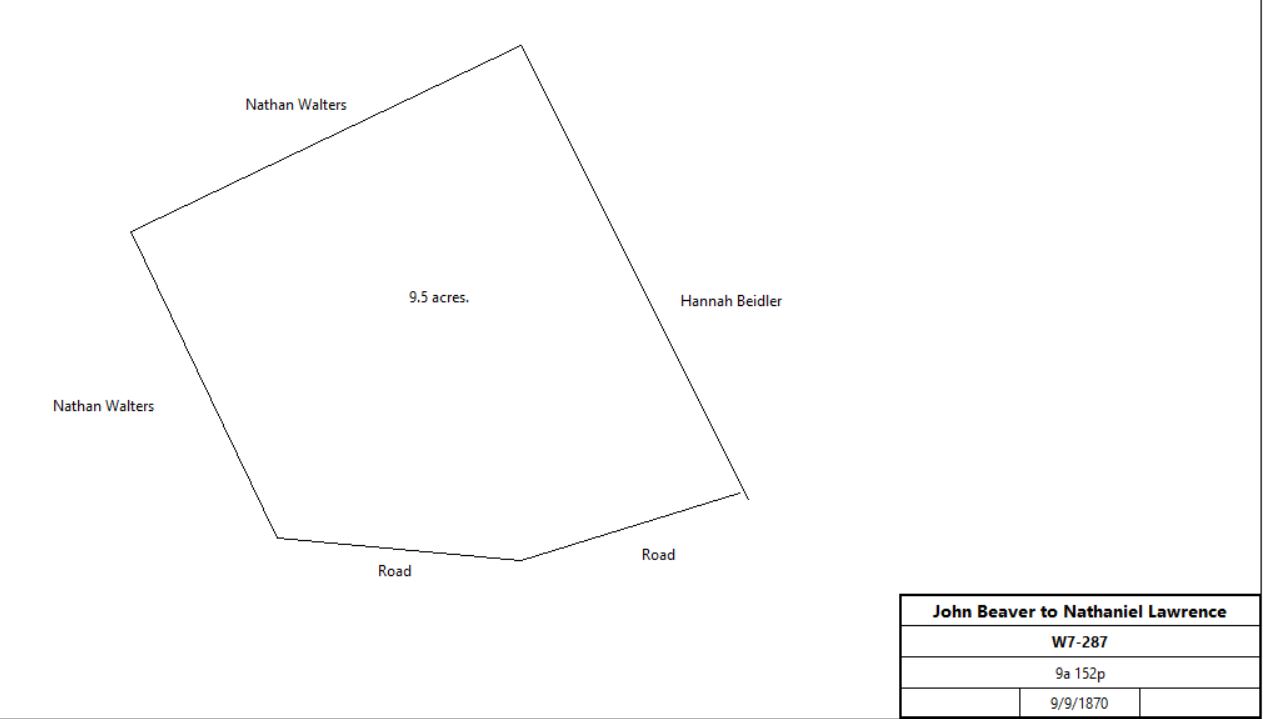
John & Martha Beaver |
Nathaniel Lawrence |
9/9/1870 |
9a 152p |
$881 45c |
W7-287; messuage |
|
John D. Evans, executor of the will of Nathaniel Lawrence |
William Miller |
5/15/1873 |
9a 152p |
$1,650 |
K8-42 |
William & Clara Miller |
Nathan Walters |
3/29/1879 |
9a 152p |
$1,300 |
D9-13 |
|
|
|
|
|
|
|
|
|
|
|
|
|
Table C.4 Abel Griffith
|
From |
To |
Date |
Area |
Cost |
Reference |
|
|
|
|
|
|
Proprietors |
Abel Griffith |
3/13/1738 |
94a |
|
See Abel Griffith Warrant, Survey A76-284, and Comm. Book 4-1, p 207. |
Abel Griffith |
|
1739 |
|
|
Tax (last entry); no Chester County will or administration |
|
|
|
|
|
|
|
|
Patent: John Penn, Thomas Penn and Richard Penn to Abel Griffith, dated 3/13/1738, recorded April 9, 1739 in patent Comm .Book 4. Vol. 1 page 207.
Recites warrant 12-9-1736 and survey thereon 3-7-1738 to Abel Griffith for tract in Tredyffrin Township, BEGINNING at a heap of stones corner of Thomas German; thence ENE by Thomas James 206 perches to a post in line of George Hughes; thence by same and vacant land NNW 78 perches to a hickory; thence by vacant land WSW 206 perches to a black oak, and SSE 78 to beginning.
Containing 94 Acres and Allowance. And grants releases and confirms said land to Abel Griffith.
Consideration 14 Pounds 11 Shillings 4 pence.
|
