|
Note: in these deed histories distances are quoted in perches (p) of length 16.5 feet. Areas are quoted in acres (a) and square perches (p). There are 160 square perches to an acre. In a few cases roods (a quarter of an acre) are also used.
|
|
|
From |
To |
Date |
Area |
Cost |
Reference |
|
|
|
|
|
|
Penn |
Richard Hunt |
3/1 or 2/1683 |
500a |
|
Patent A1-76 (Incorrect)? The History of Old Eagle School by Henry Pleasants (available as free Google ebook).
Richard Hunt of Bromiyard, Hereford; Chirurgeon. |
Richard Hunt |
William Batch |
8/24/1684 |
500a |
|
Lease Phila. C-1-323 Aka William Beach. Of Leominster, Hereford |
Richard Hunt |
William Batch |
8/24/1684 |
500a |
|
Release Phila. C-1-324 |
William Batch |
|
|
|
|
Died testate |
Grace Batch (wife) & trustees of will |
Benjamin Davis/Davies |
1/15 or 16/1701 |
500a |
|
|
Benjamin Davis of Bristol (PA or England?) |
|
1715 |
|
|
Tax records; non-resident land owner |
Benjamin & Patience Davis |
Timothy Davis, Margaret Miles, Rice Thomas, & Samuel Nutt |
8/30/1716 |
500a |
|
Lease Phila. F-1-341 Release Phila. F-1-342 |
Patience Davis |
Timothy Davis et al |
1716 |
500a |
|
Release Phila. F-1-350 |
Margaret Miles, Rice Thomas, & Samuel Nutt |
Timothy Davis |
10/11/1717 |
450a or 500a? |
|
Q-166 Release. 50a in SE corner sold off. bounded on SSE side by late lands of Hugh Samuel and John Evan on the NNW, WNW lands of William Jerlo and on ENE with reputed lands of Weales & Jones (see table K.6). |
Timothy Davis |
|
2/19/1747 |
|
|
Will. Sale to pay duty, remainder to son Benjamin Davis, See tables K.3 & K.4 |
|
|
Survey – In the Great Valley, in said County of Chester, bounded SSE by Hugh Samuel and John Evan, on the NNW, by vacant land on the WSW end, by William Jerlo, and ENE end by Weales and Jones.
Q-166 Whereas the said 500 acres since the first grant thereof hath been equally located and laid out in the Great valley, in the County of Chester, being bounded on the SSE side by the lands of Hugh Samuel and John Evan, on the NNW side by vacant land, on the WSW side by William Jerlo and on the ENE by reputed land of Weals and Jones.
|
|
Table K.1 – Edward Jones property
|
From |
To |
Date |
Area |
Cost |
Reference |
|
|
|
|
|
|
Timothy Davis |
Edward Jones sr. |
10/19/1717 |
94a |
|
|
|
|
|
|
|
|
Edward Jones sr. |
Amos Jones |
1717 - 1763 |
|
|
East end of 94a |
Edward Jones of Radnor, yeoman |
Samuel Morgan of Radnor, yeoman |
1 Dec 1749 |
94a |
|
G-573 Mortgage |
Amos Jones |
|
1760 |
34a |
|
Tax records |
Amos & Hannah Jones |
Joseph Williams |
1/4/1763 |
34a |
£50 |
M-551; mortgage due 1/4/1766 |
Amos Jones |
|
1765 |
34a |
|
Tax records |
Amos & Hannah Jones |
Joseph Norris |
1/6/1767 |
|
£60 |
P-61; mortgage due 1/6/1768 |
Amos Jones |
|
1767 |
34a |
|
Tax records |
Amos Jones |
Peter Matson |
|
34a |
|
Q-94 mortgage |
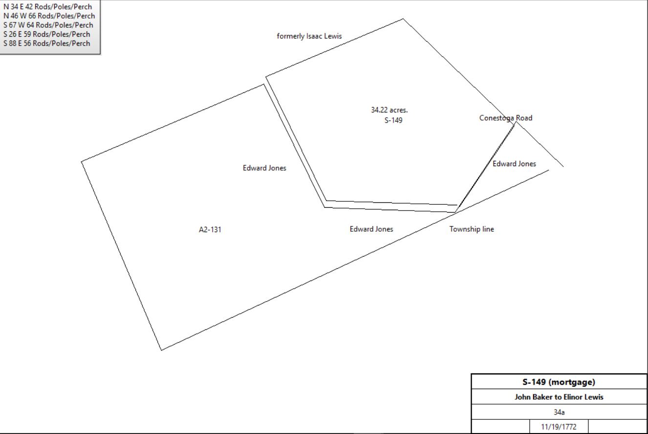
John Baker |
Elinor Lewis |
11/19/1772 |
34a |
|
S-149 mortgage |
|
John Baker |
|
11/26/1774 |
34a |
|
Inquisition on action by John Tucker (Elinor Lewis mortgage)
Deemed able to pay. Neighbors Edward Jones, Daniel Showalter, Esther James |
Amos Jones |
|
1779 |
34a |
|
Tax records |
Amos & Hannah Jones |
Thomas Pennington |
1767 - 1782 |
34a |
|
|
Thomas Pennington |
|
1781 |
30a |
|
Tax records |
Thomas Pennington |
Richard Miles |
5/10/1782 |
34a |
|
|
Richard Miles |
Adam Siters |
12/4/1795 |
34a |
|
O2-370 |
|
Adam Siters |
|
Before 1799 |
|
|
Died; Glass tax |
William Siter jr. |
Edward Siter |
9/10/1813 |
42a |
$4,720 |
I3-181 in Tredyffrin |
Edward & Sarah Siter |
Henry T. Evans |
4/1/1839 |
47a 60p |
|
R4-325 in Tredyffrin & Radnor |
Henry T. & Elizabeth M. Evans |
Thomas E. Bennett & Titus T. Bennett |
4/1/1852 |
47a 38p |
|
R5-2 |
Thomas E. & Matilda P. Bennett & Titus T. Bennett |
Richard Martin |
4/3/1854 |
47a 38p |
|
U5-583 Messuage & lot of land in Tredyffrin & Radnor |
Richard & Hannah Martin |
Charles Bittle |
3/16/1867 |
47a 38p |
|
G7-99 |
Charles Bittle |
Richard & Hannah Martin |
3/16/1867 |
|
$4,000 |
R2-571? Mortgage |
Charles & Sarah Bittle |
John Palmer |
6/27/1870 |
24a 54p |
|
U7-354 Lot in Tredyffrin |
John Palmer |
|
1883 |
60a |
|
Breou |
Emily Bittle, heir of Charles Bittle |
A. Stroud |
4/13/1903 |
|
$16,000 |
I12-359 |
A. Stroud |
A. Campbell |
7/3/1916 |
20.087a |
$1 |
B15-57; Campbell’s Nursery, Tredyffrin & Radnor |
|
|
|
|
|
|
Edward Jones sr. of Radnor |
Edward Jones jr. of Radnor |
1/1/1765 |
51a |
£100 |
A2-131; 2 tracts; see S-149 deed plan |
Edward Jones |
|
1791 |
40a |
|
Tredyffrin tax records. |
|
|
|
|
|
|
Edward Jones jr |
Abigail Miles |
4/20/1792 |
|
|
Died. Will probated 12/23/1793. Delaware Will Book A-126 |
Abigail Miles |
Adam Siters |
12/4/1793 |
~20a |
|
O2-368 |
|
Edward Jones jr |
Edward Pugh |
4/20/1792 |
45a |
|
Will & Mortgage book M-321 |
John Pugh |
|
1795 |
40a |
|
Tredyffrin tax records. |
John Pugh |
|
1797 |
40a |
|
Tredyffrin tax records. |
Edward Pugh (occupied by John Pugh) |
|
1798 |
40a |
|
Glass tax |
John Pugh |
|
1798 |
40a |
|
Tredyffrin tax records. |
John Pugh |
|
1799 |
40a |
|
Tredyffrin tax records. 2 horses, 2 cattle |
Edward Pugh |
|
9/1/1864 |
|
|
Of Radnor township died. Will dated 3/10/1859, probated 10/4/1864 |
Trustee of estate of Edward Pugh |
A. Crawford Anderson |
3/21/1874 |
54a 1r 15p |
$8,500 |
R8-70 |
A. Crawford & Elizabeth G. Anderson |
Levi E. Warner |
7/30/1875 |
54a 1r 15p |
$11,500 |
R8-72 (same description as R8-70) |
Levi E. Warner |
|
1880 |
|
|
Tredyffrin, born 1822. 1880 census |
Levi E. Warner |
|
1883 |
54a |
|
Breou's Atlas |
|
|
|
G-573 Mortgage Edward Jones stands bound to Samuel Morgan for £80 conditioned for payment of £40 plus interest in yearly payments to be paid in full on or before 1 Dec 1755. Edward Jones to better secure said payment grants to Samuel Morgan a tract in Tredyffrin bounded by land of William Terlo, Samuel Harrison & Edward Jones. Delivered in the presence of John Jerman, William George & William Evans, peaceful possession delivered in the presence of James Miles & John , Shelton. Recorded 11 Apr 1750.
M-551 A tract of land in Tredyffrin bounded by land of Edward Jones, Conestoga Road & land of Isaac Lewis.
A2-131 #2 beginning at a corner of Hugh Samuel, thence along Conestoga Road N46°W 28p, thence S34°W by Amos Jones 47p to a spanish oak, N88°W by said Jones 56p to a sassafras, thence N26°W 59p to a black oak, S67°W by Jenkin Lewis 85p to the Easttown line and S23°E along same 88p to a corner of Radnor, thence N65°E along Radnor township line 183p to the place of beginning.
Will Book A-126 I give and devise to Abigail Miles, daughter of Richard Miles of Tredyffrin township in the County of Chester and to her heirs and assigns forever a messuage and two lots of land situate partly in Radnor township, in Delaware County, and partly in Tredyffrin township containing about _ acres, the messuage and lots being now and for several years past in the possession of the said Richard Miles, subject to the payment of £20 money of this State to Sarah Miles, sister of the said Abigail Miles when the said Sarah attains 18 years.
O2-368 Beginning at a post or stone in the line of Radnor township, thence by lands of Robert Kennedy and the Lancaster Road to the corner of Richard Miles tract this day conveyed to Adam Siters thence by the same land S34°W _ to a Spanish Oak corner said to have stood in the said Radnor township; thence along the same now dividing between the said tract and Edward Siters’ tract to the lane near the Hill house; thence along the lane to the fence below the little orchard and along the same to a marked white oak in the meadow fence thence along said fence to the line of Robert Kennedy’s land; thence along the same to the line of Adam Siters’ land; thence by the same to the corner of the present describing lands formerly bought of Hugh Samuel; thence by the line and fence dividing the same from said Adam Siters’ land the several courses thereof to the line of Robert Grover’s land; thence by the same and lands of Robert Kennedy to the place of beginning.
O2-370 Tract in Tredyffrin beginning at a Spanish Oak in the Radnor township line thence N34°E 42p to the Lancaster Road; thence by road N46°W 66p to a white oak; thence by Susan Lewis S67°W 64p; thence by Edward Pugh S26°E 59p to a sassafras; thence S88°E 53a to the place of beginning.
I3-181 Beginning at the turnpike road where the county line crosses the same, thence S62°W 50.8p to a heap of stones, thence W 56p to a stake; thence N29½°W 59p to a gum tree; thence N62°E to the middle of the Old Lancaster Road; thence S50°E 94p to the place of beginning.
R8-70 Messuage and tract of land situated in Tredyffrin township, beginning at a stone in Valley Forge Road, a corner of land of Peter Latch, Thomas Campbell, William Moore, and John and Ellen King N60½°E 86.55p to a gum tree, thence by John Palmer S31° 15’E 60p to a stake, thence by Palmer and Charles Bittle N87° 27’E 56.24p to a stake, thence by land of Bittle S13° 40’E 12p to a stake in Sugartown Road, thence by middle of same S78° 50’W 27.76p to a stake in a walnut stump, and S59° 10’W 107p to a stone in the middle of Valley Forge Road, thence along middle of same N31°W 90.72p to the place of beginning.
|
Table K.2 – Jenkin Lewis property
|
From |
To |
Date |
Area |
Cost |
Reference |
|
|
|
|
|
|
Timothy Davis |
Jenkin Lewis |
10/19/1717 |
150a |
£56 10s |
Q-169 |
Timothy Davies |
|
1718 |
|
|
County tax |
Jenkin Lewis |
|
1718 |
|
|
County tax |
Timothy Davis |
|
1719 |
|
|
County tax |
Jenkin Lewis |
|
1719 |
|
|
County tax |
Timothy Davis |
|
1720 |
|
|
County tax |
Jenkin Lewis |
|
1720 |
|
|
County tax |
Timothy Davis |
|
1721 |
|
|
County tax |
Jenkin Lewis |
|
1721 |
|
|
County tax |
Timothy Davies |
|
1722 |
|
|
County tax |
Jenkin Lewis |
|
1722 |
|
|
County tax |
Timothy Davies |
|
1724 |
|
|
County tax |
Jenkin Lewis |
|
1724 |
|
|
County tax |
Timothy Davies |
|
1725 |
|
|
County tax |
Jenkin Lewis |
|
1725 |
|
|
County tax |
Timothy Davis |
|
1726 |
|
|
County tax |
Jenkin Lewis |
|
1729 |
|
|
County tax |
Timothy Davies |
|
1739 |
|
|
County tax |
Jenkin Lewis |
|
1739 |
|
|
County tax |
Jenkin Lewis |
Isaac Lewis (eldest son) |
1748 |
110a |
|
Will |
Jenkin Lewis |
Enos Lewis (son) |
1748 |
40a |
|
Will |
Isaac Lewis |
|
1760 |
120a |
|
County tax |
Isaac Lewis |
Peter Matson |
2/10/1755 |
150a |
£73 |
I-378 Mortgage |
Isaac Lewis |
Peter Matson |
3/10/1759 |
150a |
£110 |
L-249 Mortgage |
Isaac Lewis |
Peter Matson |
11/28/1761 |
150a |
£149 |
M-280 Mortgage |
Sheriff (John Fairlamb) Property of Isaac Lewis |
James McCann |
5/27/1762 |
150a |
|
N-95 |
James & Anne McCann |
Amos Jones |
4/14/1763 |
95a 54p |
|
|
Amos & Mary Jones |
Paul Sherating |
12/8/1763 |
95a 54p |
|
|
Sheriff (John Fairlamb) Property of James McCann |
Thomas Wharton |
8/22/1764 |
|
|
|
Paul Sharridan |
|
1765 |
90a |
|
Tax. 75a cleared, 15a woodland |
Thomas & Rachel Wharton |
Jacob Delong |
12/17/1766 |
74½a |
£370 |
W2-413; see table K.2.3 |
|
|
|
|
|
|
Paul Sharadon |
|
1767 |
94a |
|
Tax. |
Paul Sherittan |
John Stamper |
5/10/1769 |
95a 54p |
£150 |
P-484 mortgage; blacksmith |
Paul Sharradan |
|
1778 |
90a |
|
Tax. |
Paul & Catharine Sherating |
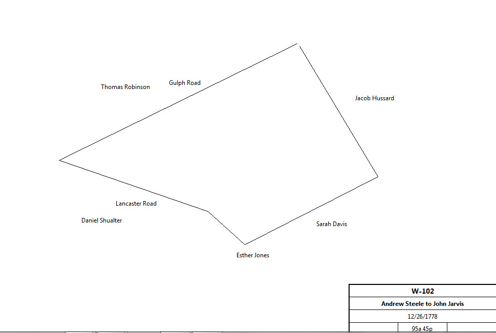
Andrew Steele |
12/21/1778 |
95a 54p |
|
|
Andrew & Mary Steele |
John Jarvis |
12/26/1778 |
95a 54p |
£1837 |
W-102 |
|
John & Elizabeth Jarvis |
Jacob Geil |
4/14/1786 |
95a 54p |
£890 |
B2-541 |
Jacob & Ann Geil |
David Markley |
4/6/1793 |
95a 54p |
£750 |
H2-435 |
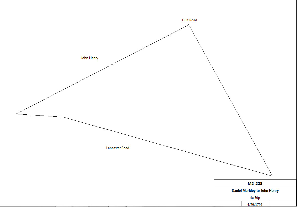
Daniel & Elizabeth Markley |
John Henry |
4/29/1795 |
4a 50p |
£34 10s |
M2-228 |
|
Daniel Markley |
|
1798 |
89a |
|
Glass tax |
Daniel & Elizabeth Markley |
John Large of Philadelphia |
10/15/1816 |
94a 54p |
$5,000 |
M3-315; same description as W-102; no mention of John Henry tract |
Break in title presumably covered by Philadelphia deeds |
|
|
|
|
|
Elizabeth Markley (widow) |
Charles Thatcher |
1819 |
33a 141p |
|
P3-313 |
Robert Waln |
Pattison Hartshorne |
4/23/1819 |
94a 54p |
|
Philadelphia deed MR, #23, p. 381 |
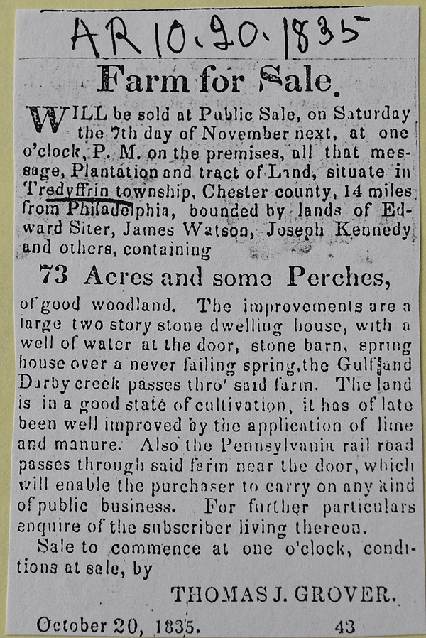
from the Village Record February 26, 1823
A valuable Tavern Stand and Farm, At Public Sale.
Will, be sold, on Saturday, the 22d of March, on the premises, that Valuable Tavern and Farm, Sign of the LAMB:- situated in Tredyffrin Township, Chester County, on the Lancaster Turnpike, 15 miles from Philadelphia, at the intersection of the Valley Forge and Gulph Roads.- Consisting of about 75 Acres of Land.- 11 Acres of which are Woodland, the remainder is divided into convenient Fields, and in a high state of cultivation, with a large Apple Orchard, bearing Fruit of good Quality.- The Improvements are - a large Two Story Stone premise, with four Rooms on a Floor - good Stone Sheds and Stabling, and two pumps of good Water. ALSO, a Two Story Stone Dwelling, with two Rooms on a Floor; adjoining which is a log Barn, and a Pump of good Water.
Terms made known at the time of sale, which will accommodating to the Purchaser. For further particulars inquire of
GEORGE REES, West Philadelphia. |
Jesse Sharp, sheriff (estate of George Rees) |
John & Sophia Elliott |
8/2/1824 |
75a in Tredyffrin & Easttown |
|
Sheriff’s Deed 3-43; tavern |
John & Sophia Elliott |
Jacob Clinger |
8/16/1824 |
75a in Tredyffrin & Easttown |
$5,500 |
X3-278; tavern (no description of land) |
Pattison Hartshorne of Philadelphia |
Joseph Kennedy |
6/13/1826 |
94a 54p |
$2,000 |
Z3-634; essentially same description as W-102 |
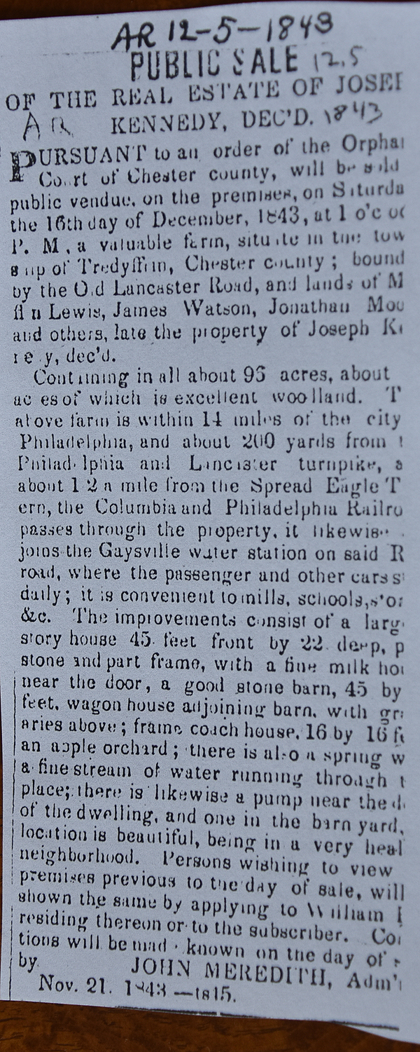 |
John Meredith, admin. of will of Joseph Kennedy |
William Rue |
4/1/1844 |
95a 24p (survey of George Hartman) |
$3,846 |
Z4-183 |
William Gamble, executor of the will of Jacob Clinger |
John Famous |
3/31/1845 |
33a |
$1,000 |
U5-11 |
William & Ellen Rue |
William White |
4/1/1854 |
95a 24p |
$6,000 |
U5-555 |
David McNutt (Sheriff); suit of John A. Riter aginst William White |
George Emlen |
4/30/1857 |
95a 24p |
$10,160 |
Sheriff’s Deed Book 6, page 104 |
George Emlen |
Martha Wentworth (nee Emlen), sister |
12/23/1853 (will) |
All my estate |
|
Inheritence |
John & Susanna Famous |
Martha Wentworth |
4/2/1860 |
33a |
$3,300 |
O6-340 |
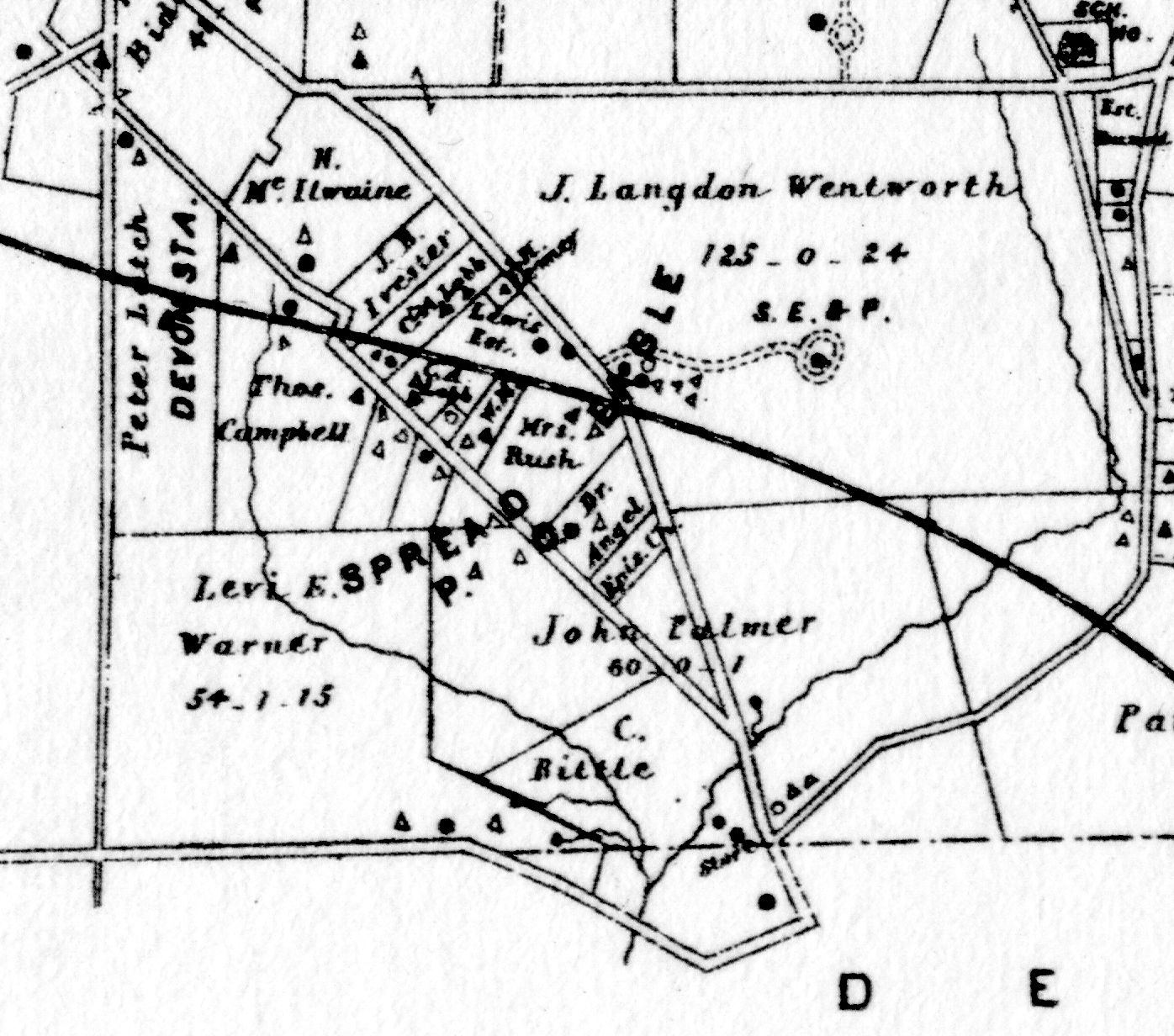
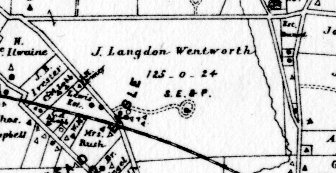
J. Langdon Wentworth |
|
1873 |
|
|
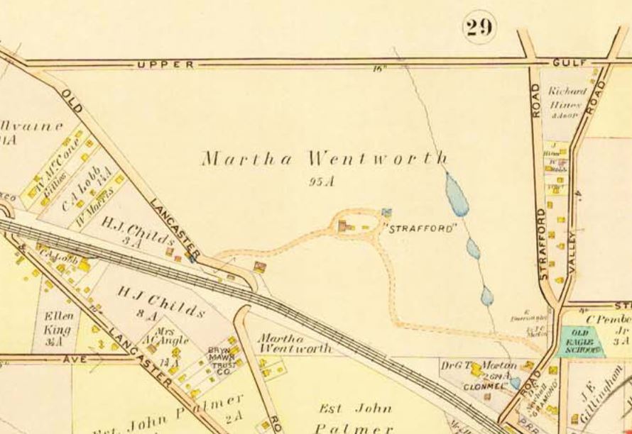
Witmer’s Atlas |
J. Langdon Wentworth |
|
1883 |
125a |
|
Breou’s Atlas |
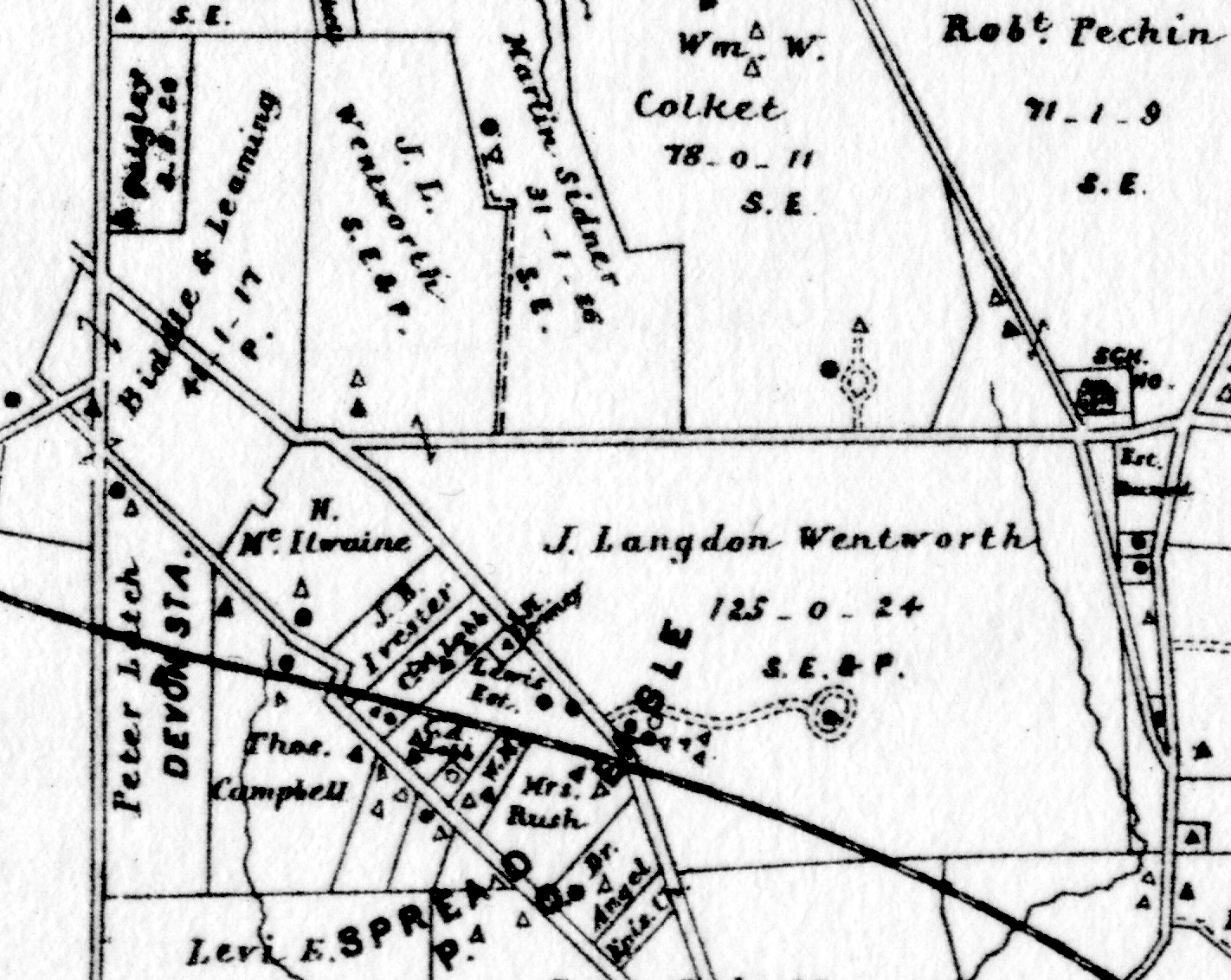
|
J. Langdon Wentworth |
|
1887 |
Strafford estate plus 33 acres |
|
Atlas |
Martha & J. Langdon Wentworth |
John R. Baker jr. |
12/24/1889 |
10.265a |
$11,804 75c |
O10-291, part of O6-340 |
Martha Wentworth |
|
1897 |
94.2a (Strafford) plus 18 a |
|
Atlas |
Martha Wentworth |
|
1900 |
95a (Strafford) plus 18 a |
|
Atlas |
Martha Wentworth |
|
3/18/1900 |
95a (Strafford) plus 18 a |
|
died |
Charles Wentworth and Mary Foote, (children of Martha Wentworth) executors of the will of Martha Wentworth |
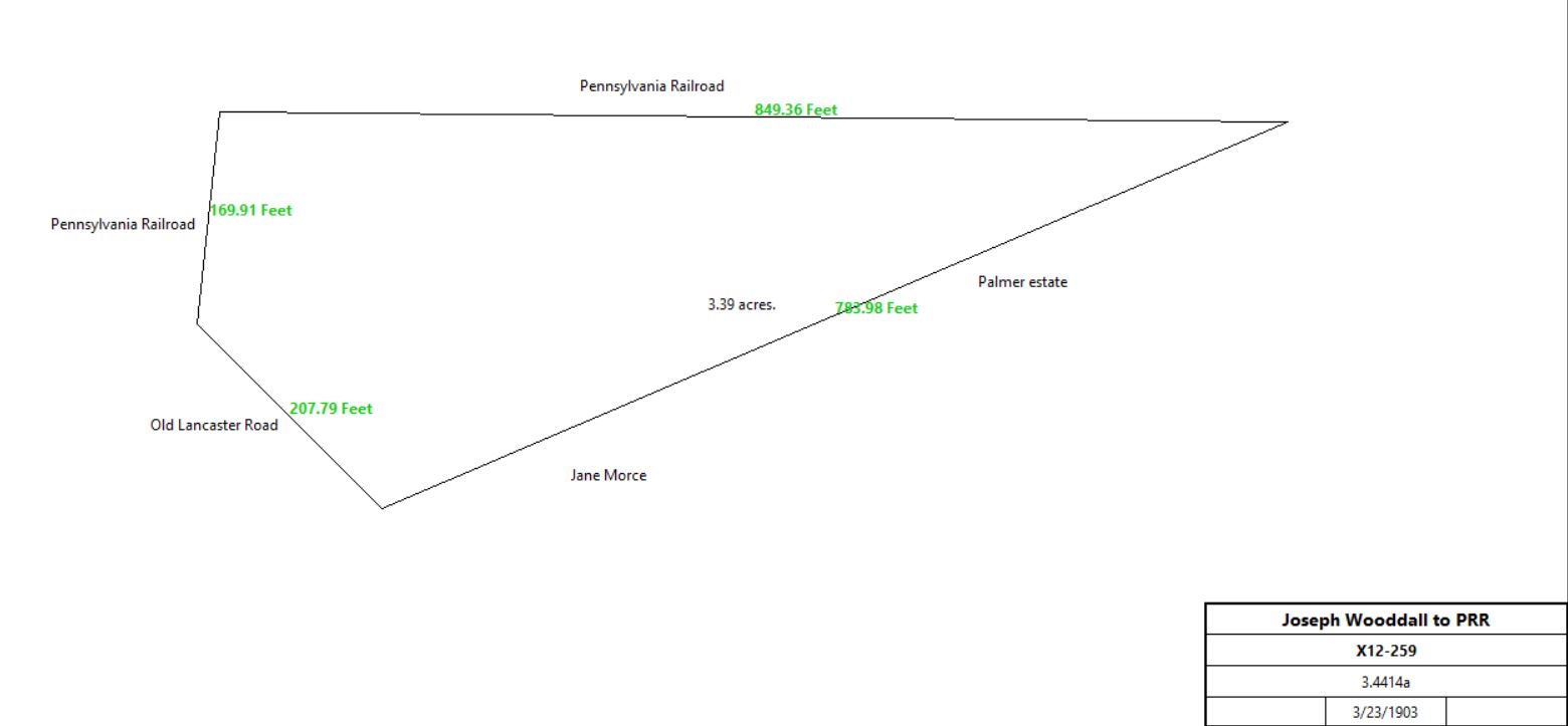
Joseph Wooddall |
3/23/1903 |
3.4414a |
$4,301 75c |
I12-356 |
Joseph Wooddall |
Pennsylvania Railroad Co. |
3/23/1903 |
3.4414a |
$4,301 75c |
X12-259 |
|
Charles Wentworth et al |
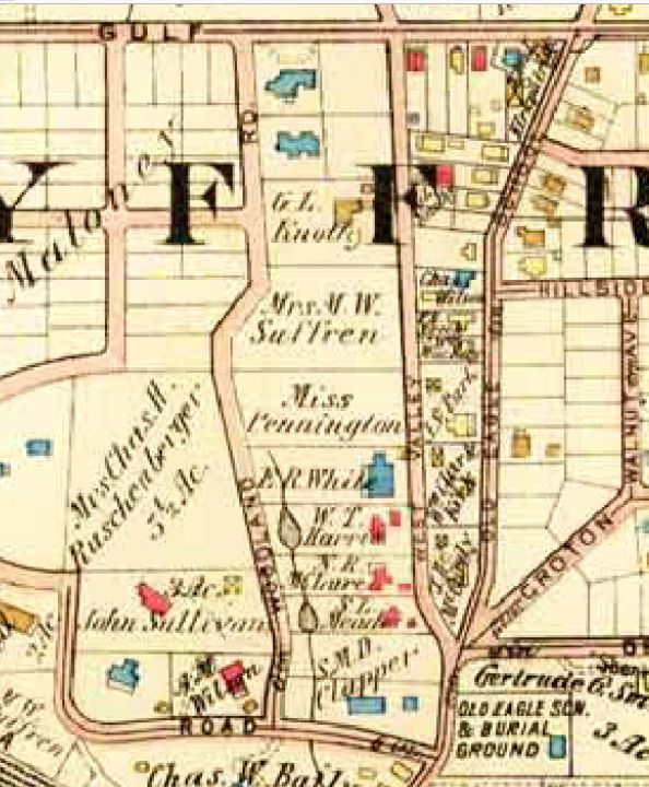
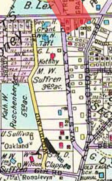
Martha W. Suffren |
6/18/1906 |
110.673a + 0.308a |
$77,450 |
V12-558 |
Mrs M. W. Suffren |
|
1908 |
18a |
|
“Homestead”; Atlas |
Wentworth lots |
|
1908 |
Strafford estate area |
|
Atlas |
Mrs M. W. Suffren |
|
1912 |
18a |
|
“Homestead”; Atlas |
Mary G. W. Foote |
|
1912 |
39.703a; (Strafford) |
|
Atlas |
Charles M. Lea |
|
1920 |
103a (including 18a) |
|
Westthorpe Farm; Atlas |
Mary G. W. Foote |
|
1920 |
34a; (Strafford) |
|
Atlas |
Charles M. Lea |
|
1926 |
103a (including 18a) |
|
Westthorpe Farm; Atlas |
Michael A. Maloney |
|
1926 |
Mary Foote estate divided into lots |
|
Atlas |
Charles M. Lea |
|
1933 |
103a (including 18a) |
|
Westthorpe Farm; Atlas |
Michael A. Maloney |
|
1933 |
Divided into lots |
|
Strafford Heights development; Atlas |
M. W. Suffren |
|
1933 |
21.5a (part of original Wentworth estate) |
|
Sunset Hills development; Atlas |
|
|
Q-169 Beginning at a stake for a corner set in the WSW end of said 500 acres by William Jerlo’s land, runs thence by the same Jerlo’s land NNW 104p unto the north westernmost corner of said 500 acres, thence ENE along the NNW-most side 231p to stones for a corner, by sold or to be sold out of the 500 acres to David Pugh then by same land SSE 104p to a stake for a corner, thence along the same and by sold or to be sold to Edward ? WSW 231p to the place of beginning.
Will of Jenkin Lewis
Jenkin Lewis by his last will bequeathed 40 acres part of said 150 acres unto his son Enos who died intestate without heirs begotten of his body, whereby said 40 acres of land devolved to Isaac Lewis, his only brother, and to his heirs, and the remaining 110 acres unto his son Enos, who died without heirs begotten, Ann Lewis his widow, and his said son Isaac, and after the decease of the said Ann, the whole to go to his said son Isaac, his heirs and assigns forever.
I-378 Mortgage. On 10 Feb 1755 Isaac Lewis of Tredyffrin, yeoman, to Peter Matson of Upper Merion in the County of Philadelphia, yeoman. Isaac Lewis stands bound to Peter Matson for £146 conditioned on payment of £73 plus interest on 9 Feb 1756. Isaac Lewis to better secure said debt granted to Peter Matson a tract in Tredyffrin bounded by land of William Jerloes, land late of Timothy Davis, lands of David Pugh & Edward Jones containing 150 acres. Signed Isaac Lewis. Delivered in the presence of Joseph Tucker & John Johnston. Recorded 10 Mar 1755.
L-249 Mortgage. On 10 Mar 1759 Isaac Lewis of Tredyffrin, laborer to Peter Matson of Upper Merion, in the county of Philadelphia, yeoman. Isaac Lewis stands bound to Peter Matson for £221 conditioned on payment of £110.10 plus interest on 10 Mar next. Isaac Lewis to better secure said debt granted to Peter Matson a tract in Tredyffrin bounded by land of William Jerlee, land late of Timothy Davis, land of David Pugh & Edward Jones containing 150 acres. Signed Isaac Lewis. Delivered in the presence of John Johnston & Mary Johnston. Recorded 8 May 1759. (Lll:249).
M-280 Mortgage. On 28 Nov 1761 Isaac Lewis of Tredyffrin, laborer to Peter Matson of Upper Merion in the County of Philadelphia, yeoman. Isaac Lewis stands bound to Peter Matson for £298 conditioned on payment of £149 plus interest on 28 Nov next. Isaac Lewis to better secure said debt granted to Peter Matson a tract of land in Tredyffrin bounded by land of William Jerlee, land late of Timothy Davis, David Pugh & Edward Jones containing 150 acres. Signed Isaac Lewis. Delivered in the presence of Thomas Tucker & John Johnston. Recorded 23 Mar 1762. (M12:280).
N-95 Sheriffs Deed. On 12 Feb 1763 John Fairlamb, sheriff of Chester County to James McCann of Cecil County, Maryland. Whereas Thomas Potts, Samuel Potts & John Potts, Jr. in the Court of Common Pleas recovered against Isaac Davis (sic) of Tredyffrin a debt of £96.16 & 45 shillings damages to be levied on the lands of Isaac Davis (sic). John Fairlamb, sheriff, for £209.16.9 granted to James McCann a tract of land in Tredyffrin bounded by land of William Jerloe, land late of Timothy Davis, David Pugh & Edward Jones containing 150 acres, subject to a mortgage securing the payment of £149 & interest to Peter Matson which remains unpaid. Signed John Fairlamb, sheriff. Delivered in the presence of Nicholas Fairlamb & Frederick Fairlamb. Recorded 19 July 1763. (N13:95).
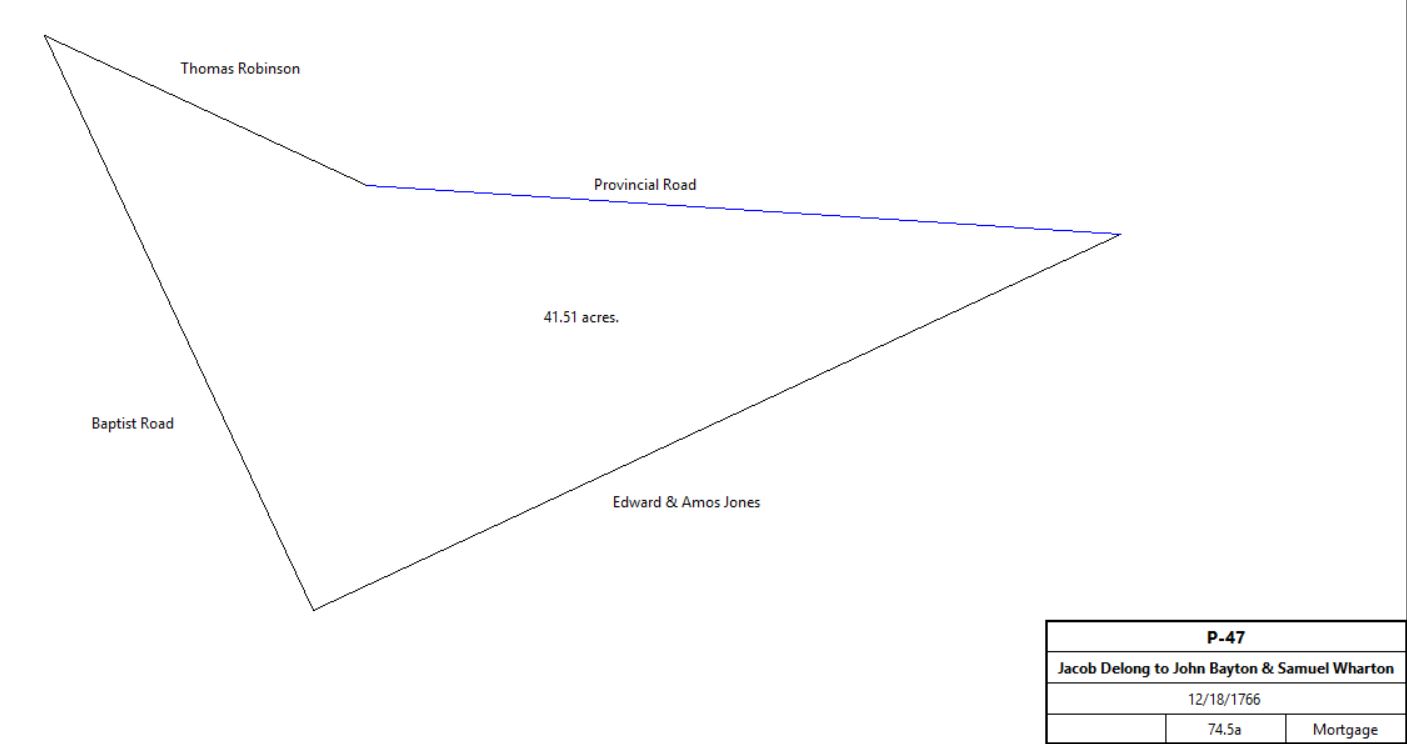
P-47, Mortgage. Jacob Delong of Tredyffrin to John Bayton and Samuel Wharton, 12/18/1766. £220. (south of Provincial Road and east of Baptist road – Strafford?). Neighbors: Edward & Amos Jones, Provincial Road, Thomas Robinson, Baptist Road. 74½a.
|
Table K.2.1.a Sponseller House
|
From |
To |
Date |
Area |
Cost |
Reference |
|
|
|
|
|
|
|
|
1873 |
|
|
House on Witmer’s atlas |
|
Frank Donatoni |
Possibly 1930 and 1923 |
|
|
tax returns |
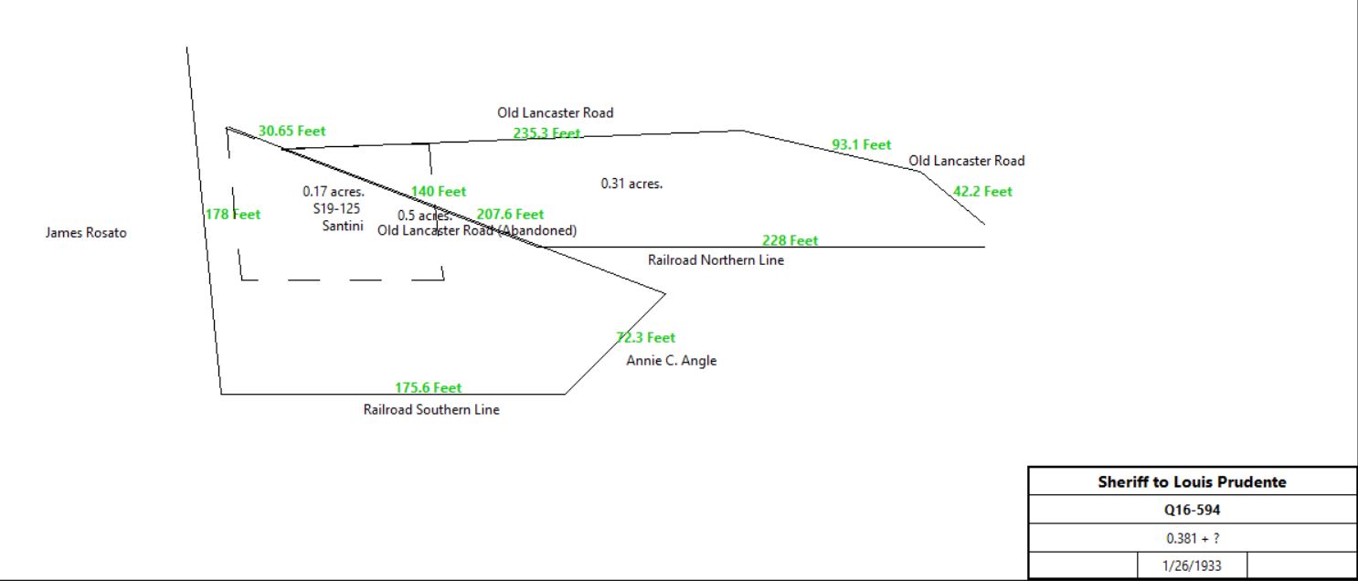
A. M. Seldomridge, sheriff, debt of Frank & Matilda Donatoni |
Louis Prudente |
1/26/1933 |
0.381a + ? |
$1 |
Q16-594 |
|
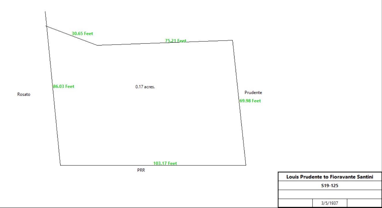
Louis & Sabbia Prudente |
Fioravante & Delphine Santini |
3/5/1937 |
|
$4,500 |
S19-125 |
|
Louis & Sabbia Prudente |
Victor & Helen Saracco |
12/2/1946 |
0.381a + ? |
$5,000 |
T22-300 with mortgage Z14-48 |
Helen & Victor Saracco |
James Mingle |
9/30/1948 |
|
|
X23-266 |
James & Ruth Mingle |
Philip John Sentner |
3/13/1956 |
|
|
N28-635 |
Philip John and Ragnhild Sentner, |
John Sponseller |
6/8/1989 |
|
|
Book 1571-509 |
|
Table K.2.1.b
|
From |
To |
Date |
Area |
Cost |
Reference |
|
|
|
|
|
|
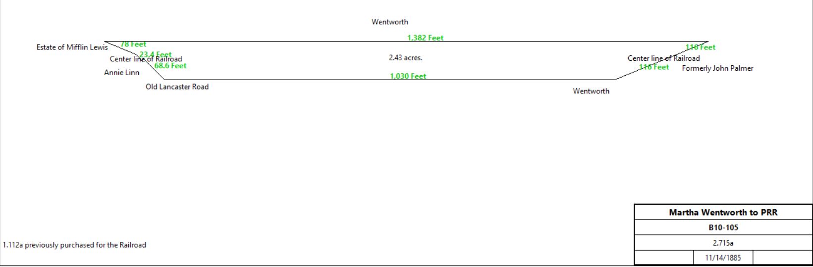
Martha & John Wentworth |
The Pennsylvania Railroad Company |
11/14/1885 |
2.715a |
$2,347 |
B10-105 |
|
|
Table K.2.1.c
|
From |
To |
Date |
Area |
Cost |
Reference |
|
|
|
|
|
|
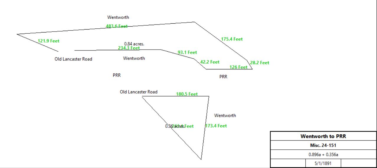
Martha & John Wentworth |
The Pennsylvania Railroad Company |
5/1/1891 |
0.896 + 0.356a |
$2,200 |
Misc. 24-151 |
|
|
Table K.2.2
|
From |
To |
Date |
Area |
Cost |
Reference |
|
|
|
|
|
|
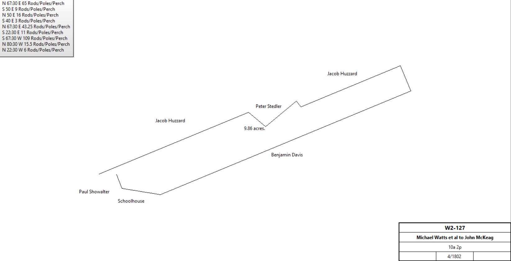
Michael Watts |
Joel Watts |
3/27/1772 |
10a 2p |
|
Recited in Michael Watts deed from 1802. Cornered on the school house land; deeds not found. See table K.5 |
Joel Watts |
|
1778 |
10a |
|
Tax |
Joel Watts |
|
1779 |
10a |
|
Tax |
Joel Watts |
|
1801 |
|
|
Died; administration |
Michael & Mary Watts, Hannah McClean, George & Mary White |
John McKeag |
4/1802 |
10a 2p |
£180 |
W2-127 |
|
Jacob Huzzard |
John McKeag |
7/21/1810 |
1a 154p |
|
Deed not found; quoted in E3-477 |
John McKeag |
Abijah Bowen |
12/27/1810 |
10a 2p + 1a 154p |
$1,100 |
E3-477 |
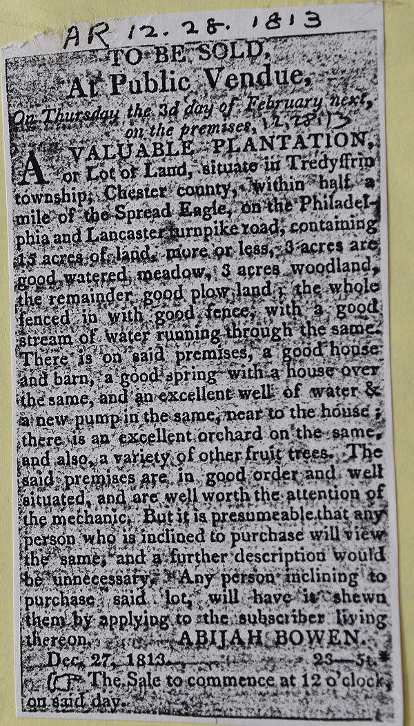
American Republican 12-28-1813
See Newspaper clipping in Document database for commentary
|
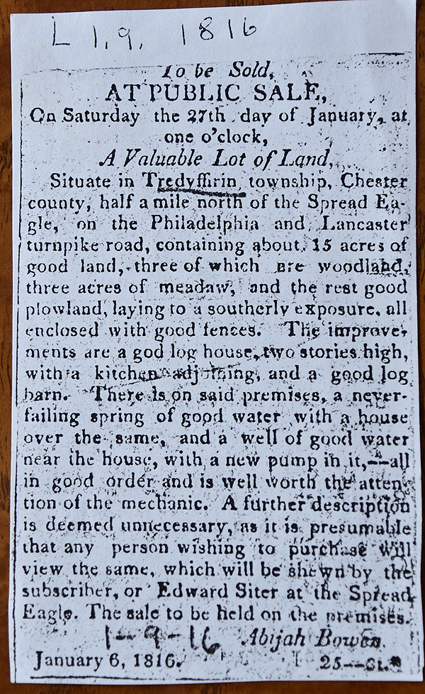
Daily Local 1-9-1816
See Newspaper clipping in Document database for commentary
|
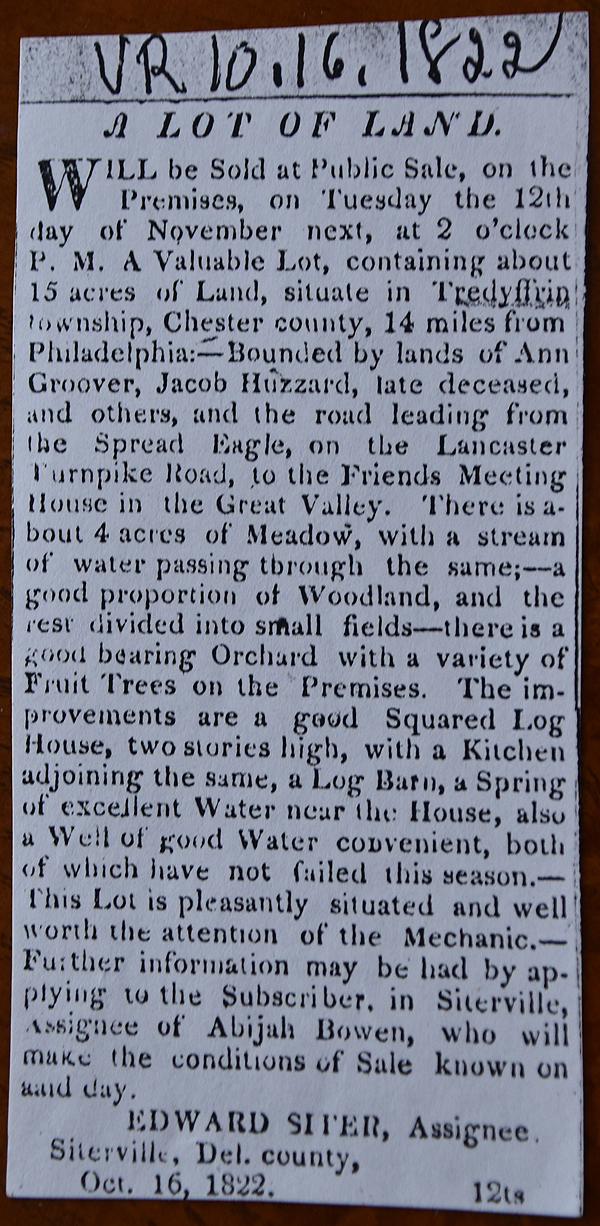
Daily Local 10-16-1822
See Newspaper clipping in Document database for commentary
|
|
Table K.2.3 Between Conestoga Road & Radnor Church Road
|
From |
To |
Date |
Area |
Cost |
Reference |
|
|
|
|
|
|
Thomas & Rachel Wharton |
Jacob Delong |
12/17/1766 |
74½a |
£370 |
W2-413 |
Jacob Delong |
John Bayton & Samuel Wharton |
12/18/1766 |
74½a |
|
Mortgage P-47 |
|
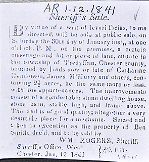
Sheriff (Jacob Delong) |
Daniel Showalter |
1770 |
|
|
W2-411 |
David Showalter |
Jacob Detwiler |
6/10/1788 |
74½a |
£300 |
E2-96; deed plan same as P-47; mentions buildings and improvements, no mention of messuage |
Jacob & Elizabeth Detwiler |
John Clymer, mason of Germantown |
4/1/1795 |
74½a |
£587 10s |
T2-71; see deed plan; mentions buildings and improvements, no mention of messuage |
John Clymer aka Glymer |
|
1798 |
|
|
Glass tax; log cabin; rented out |
John & Margaret Clymer |
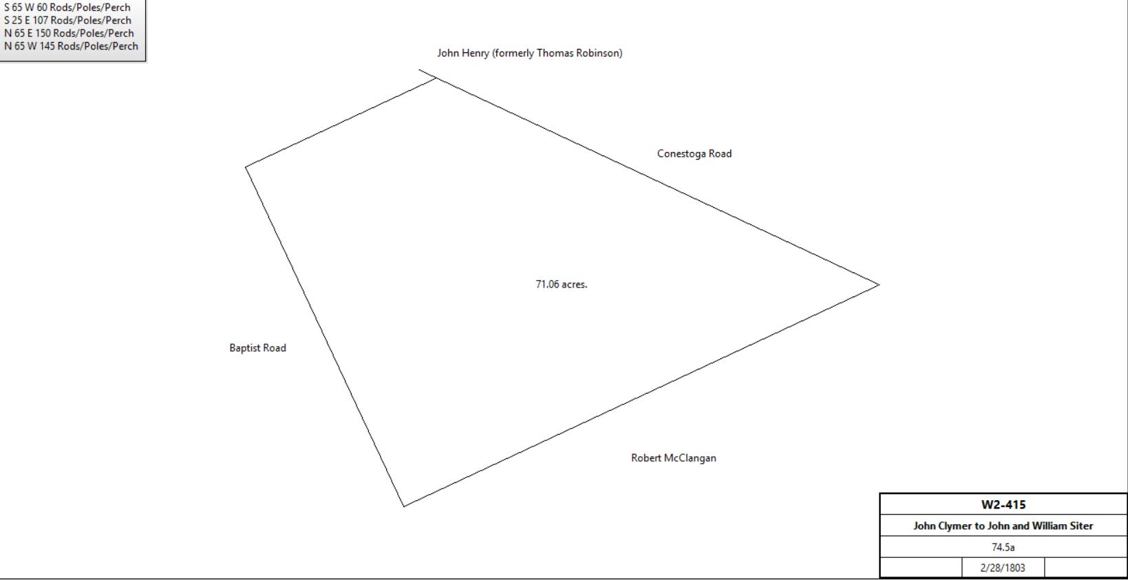
John & William Siter |
2/28/1803 |
74½a |
$2,400 |
W2-415; no mention of messuage.
See Table K.2.3.1 for later history |
|
Table K.2.3.2 |
From |
To |
Date |
Area |
Cost |
Reference |
|
|
|
|
|
|
John & Ann, and William & Mary Siter |
Elizabeth Baker & Mary Givin |
4/1/1807 |
7a 55p |
$800 |
H3-42; Stone messuage |
Mary Givin |
Elizabeth Baker |
12/21/1812 |
7a 55p |
|
H3-43; release |
Charles & Catharine Smith |
Elizabeth Baker |
3/27/1816 |
2a 20p, part of 8.5a |
$276 75c |
B7-443 |
Elizabeth Baker |
|
1821 |
|
|
died intestate |
William & Eve Baker |
Catherine Henderson |
12/28/1822 |
½ part of 10a |
$517 50c |
W3-247 |
Benjamin & Rachel Baker |
Catherine Henderson |
12/28/1822 |
½ part of 10a |
$517 50c |
W3-248 |
John Lang, administrator of the estate of Catharine Henderson |
John Woodward |
2/8/1866 |
16a 73p |
$3,385 |
A7-390 |
John Woodward |
Thomas Campbell |
4/6/1867 |
16a 73p |
$3,200 |
I7-58 |
Thomas Campbell |
|
6/28/1896 |
|
|
died |
William John Campbell & John Black, executors of the will of Thomas Campbell |
Clayton Lobb |
2/2/1894 |
16.88a, excepting railroad tract |
$2,500 |
I12-580 |
Table K.2.3.3 - moved to table K.2.3.1, Branch G |
From |
To |
Date |
Area |
Cost |
Reference |
|
|
|
|
|
|
John & Ann, and William & Mary Siter |
Charles Smith |
3/12/1810 |
8½a |
$552 50c |
E3-89; see Table K2.3.1 for earlier history. |
John & Ann, and William & Mary Siter |
Charles Smith |
4/1/1812 |
3a 13p |
$310 |
G3-190 |
Table K.2.3.4 - moved to table K.2.3.1, Branch H |
From |
To |
Date |
Area |
Cost |
Reference |
|
|
|
|
|
|
John & Ann, and William & Mary Siter |
John Godwin |
3/12/1810 |
14½a |
$725 |
F3-177; messuage & tract |
Table K.2.3.5 - Devon fireworks factory tract |
From |
To |
Date |
Area |
Cost |
Reference |
|
|
|
|
|
|
|
|
|
|
|
|
William Morrison (sheriff) - executors of Samuel McMurray |
Hugh & J. Gibson McIlvaine |
4/29/1875 |
13a |
$1000 |
Sheriff’s Deed Book 7-371 |
Hugh McIlvaine |
|
1883 - 1900 |
17a |
|
Altases |
J. Gibson McIlvaine |
|
1906 - 1926 |
13a |
|
Atlases |
|
Table K.3 John Best – Robert Kennedy – John Palmer plot
|
From |
To |
Date |
Area |
Cost |
Reference |
|
|
|
|
|
|
Timothy Davis |
John Best |
4/20/1747 |
11½a |
|
|
Sarah David |
John Best |
3/29/1750 |
20a |
|
|
John Best |
|
1760 |
10a |
|
Tax records |
John & Martha Best |
Thomas James |
11/7/1763 |
11½a & 20a |
|
|
Thomas James |
|
1765 |
30a |
|
Tax records; 15a woodland |
Thomas James |
|
1767 |
30a |
|
Tax records |
Esther James |
|
1774 |
30a |
|
Tax records |
Esther James |
|
1778 |
31a |
|
Tax records |
Esther James (widow of Thomas James) |
Patrick Kerr |
|
11½a & 20a |
|
Kerr not in Tredyffrin tax records. Lived in Radnor? |
Patrick Carr |
Mary Carr (during her life) then to son Thomas Carr |
11/9/1779 |
|
|
Will |
Thomas Carr |
Patrick Little |
8/3/1782 |
11½a & 20a |
£125 & tract of land in Cumberland County |
W-352; see deed plan |
Sheriff of Philadelphia |
Ann Donolson (nee James) |
9/24/1785 |
|
|
|
Ann James |
|
1786 |
31a |
|
Tax records |
William & Ann Donolson |
Robert Kennedy |
3/10/1791 |
11½a & 20a |
£115 |
F2-275; see deed plan |
Robert Kennedy |
|
1791 |
31a |
|
Tax records |
Robert Kennedy |
|
1795 |
45a |
|
Tax records |
Robert Kennedy |
|
1797 |
51a |
|
Tax records |
Robert Kennedy |
|
1798 |
45a |
|
Tax records |
Robert Kennedy |
Occupied by Henry Wells |
1798 |
45a |
|
Glass Tax; Log house 29’ x 22’ |
Robert Kennedy |
|
1799 |
51a |
|
Tax records |
Click to see detailed tax information between 1800 and 1832 |
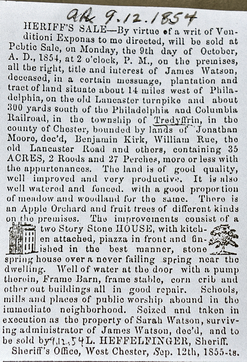
Heirs of Robert Kennedy |
James Watson (for benefit of wife Sarah Watson nee Kennedy) |
4/11/1834 |
35a 2r 27p |
$3,816 55.5c |
I4-403 |
Heirs of Robert Kennedy |
Ben Smith |
4/11/1834 |
2.5a |
$400 |
K4-48 |
Heirs of Robert Kennedy |
James Watson |
4/11/1834 |
2.5a |
$95 6.25c |
K4-118 |
 |
 |
Sarah Watson |
James K. Spencer |
3/31/1866 |
35a 2r 27p |
|
B7-541 |
James K. Spencer |
James K. Spencer |
3/31/1866 |
35a 2r 27p |
$3000 |
Mortgage P22-536 |
James K. & Elizabeth Spencer |
John Palmer |
3/30/1869 |
35a 2r 27p |
|
R7-200 |
John Palmer |
|
1883 |
60a |
|
Breou |
|
John Palmer |
7 children |
12/16/1893 |
|
|
Died intestate |
Isaac Palmer |
Henry Pleasants |
2/8/1899 |
His 1/7 part |
|
Y11-328 |
Henry Pleasants |
Edith G.P. Lewis, Emma P. Camm |
2/28/1899 |
1/7 part |
|
Y11-357 |
John Palmer jr. |
Edith G.P. Lewis, Emma P. Camm |
9/17/1900 |
His 1/7 part |
|
E12-4 |
Edith G.P. Lewis, Emma P. Camm |
|
9/19/1900 |
|
|
Deed poll; Miscellaneous 30-579 |
John H. Thomas & wife |
|
3/9/1895 |
|
|
Deed poll; Miscellaneous 26-187 |
Hannah G. Morgan |
|
1/29/1895 |
|
|
Deed poll; L11-366 |
Edwin Parrott & wife |
|
12/14/1899 |
|
|
Deed poll; Miscellaneous 29-183 |
|
|
W-352 Thomas Carr to Patrick Little, dated 8/3/1782 for 2 contiguous parcels of land. Patrick Carr’s will of 11/9/1779 bequeathed land to wife Mary Carr during her lifetime and then to son Thomas Carr. Price £125 and a tract of land in Cumberland County.
Beginning at a white oak tree, standing on the west side of Conestoga Road, thence N66°E by land late of 68 perches to a black oak sapling, thence S18°E by land of late Timothy Davis 11 perches to a black oak sapling, thence S66°W by same land 26 perches to a gum, thence S18°E 28 perches to a post, thence S19°W by same land 25 perches to a post in the east side of Conestoga Road thence N68°W 63 perches tot the place of beginning. 11½ acres.
Beginning at a corner, a black oak sapling, S60°W 27 perches to a marked gum, thence by land of John Best S27°E 72 perches to a stake in Conestoga Road, thence by land of John Samuel N60°E 64 perches to a corner stone in said Samuel’s line thence N44½°W 80 perches to the place of beginning. 26 acres.
F2-275 Messuage and 2 pieces of land:
Tract 1 – Begins at a white oak tree standing on the west side of the Conestoga Road, thence N60°E by lands late of Jenkin Lewis deceased 68p to a black oak saplin, thence S18°E by other lands of the aforesaid late Timothy Davis 11p to a black oak saplin, thence S66°E by the same lands 20p to a gum tree, S18°E by the same lands 28p to a post standing on the east side of the Conestoga Road, thence N68°W crossing said road 63p to the place of beginning. 11½
Tract 2 – contiguous and adjoining the first tract. Beginning at a corner black oak saplin, thence S60°27p (guessed W) to a marked gum tree, thence by the above mentioned lands S?E 72p (guessed 22) to a stake in the Conestoga Road., thence by lands of the late John Samuel N60°E 64p to a corner stone in said John Samuel’s line, thence N44½°W 80p to the place of beginning. 20a
I4-403 Beginning in line of Edward Siter in County line, thence N50°W 79.2p, thence N20½°11.1p to line of Joseph Kennedy, thence S64°W 75.1p to west side of Lancaster Road; thence by same S52°E 94p to middle of turnpike, and in County line; thence by County line N63°E 65.5p to the place of beginning.
|
Table K.3.1 Our Lady of the Assumption Church
|
From |
To |
Date |
Area |
Cost |
Reference |
|
|
|
|
|
|
William E. & Edith G. Palmer Lewis, Nellie May Palmer, Charles B. & Mary Eleanor Palmer, Elizabeth J. Palmer et al |
Henry D. Riley |
5/22/1906 |
16.746a & 1.54a |
$23,901 |
E13-217 Part of R7-200 |
Henry D. & Eleanor S. Riley |
Lewis A. Riley |
6/29/1920 |
1.553a+ (2 tracts) |
$1 |
V15-23 |
Lewis A. Riley |
Dennis J. Dougherty, Archbishop of Philadelphia |
2/19/1921 |
0.75a |
$1 |
V15-290 |
|
|
E13-217 Beginning at a point in the middle line of Lancaster Avenue in the line between the counties of Chester and Delaware at the distance of 73.73’ NW from a spike at the intersection of the middle of Lancaster Avenue and Eagle Road, thence extending along the middle line of Lancaster Avenue N53°13’W 443.97’ to a spike at the intersection of the middle line of Conestoga Road, thence along middle line of Conestoga Road N45°7’W 113.7’ to a stake, thence by other land of the estate of John Palmer deceased, passing a maple tree on the side of said Conestoga Road N28°51’E 741.8’ to a corner of the other land of the said estate of John Palmer deceased, thence by the same S80°40’E 458’ to the middle line of Eagle Road aforesaid in the line of the land of Pennsylvania Hall Association, thence along said middle line by said association’s land and land of said Henry D. Riley S9°20’W 129.7’ to a spike, a corner of said Riley’s land, thence by the same S55°50’E 707.2’ to another corner of said Riley’s land in the line between the Counties of Chester and Delaware, thence along said county line by land of the estate of Hannah M. Palmer, deceased, S67°2’W 494.5’ to a cherry tree, a corner of other land of said estate of John Palmer, deceased, thence by said land N77°36’W 214’ to a spike in the middle line of Eagle Road aforesaid, thence along said middle line by said land of the state of John Palmer, deceased, S6°24’W 47.65’, S26°10’W 94.1’, and S45°57’W 57.75’ tot he county line aforesaid in line of land of the estate of Hannah M. Palmer, deceased, thence along said county line by said land S67°2’W 202.34’ tot he place of beginning. 16.746a.
Beginning at a spike in the middle of Eagle Road, a corner of land of Sarah A. Hughes, also a corner of land of the Pennsylvania Hall Association, thence along said middle line of Eagle Road by said Association’s land S9°20’W 45’ to a corner of land of the estate of John Palmer, deceased, thence by said land parallel with and 60’ distance northwardly from the northernmost line of the tract above described N80°40’W 436.72’, thence still by said estate’s land N28°51’E 288.84’ to a stake, a corner of said Hughes’ land, thence by said Hughes’ land S46°54’E 409.1’ to the place of beginning. 1.54a.
V15-290 Beginning at a spike in the middle of Eagle Road, a corner of land of John Palmer’s estate, 376.55’ along middle of road from Lancaster Avenue, thence extending along middle of Eagle Road, by other land of Lewis A. Riley N6°24’E 100’ to a spike, thence still by said land S80°24’E 395.3’ to a spike on the county line, thence along county line by land of Hannah Palmer’s estate, S67°2’W 208.79’ to a cherry tree, thence by John Palmer’s estate N77°36’W 214’ to the place of beginning.
|
Table K.3.2 Other purchases of Henry D. Riley
|
From |
To |
Date |
Area |
Cost |
Reference |
|
|
|
|
|
|
James Minshall |
Owen Seery |
4/1/1861 |
60a |
$7,150 |
P6-431 |
Owen Seery |
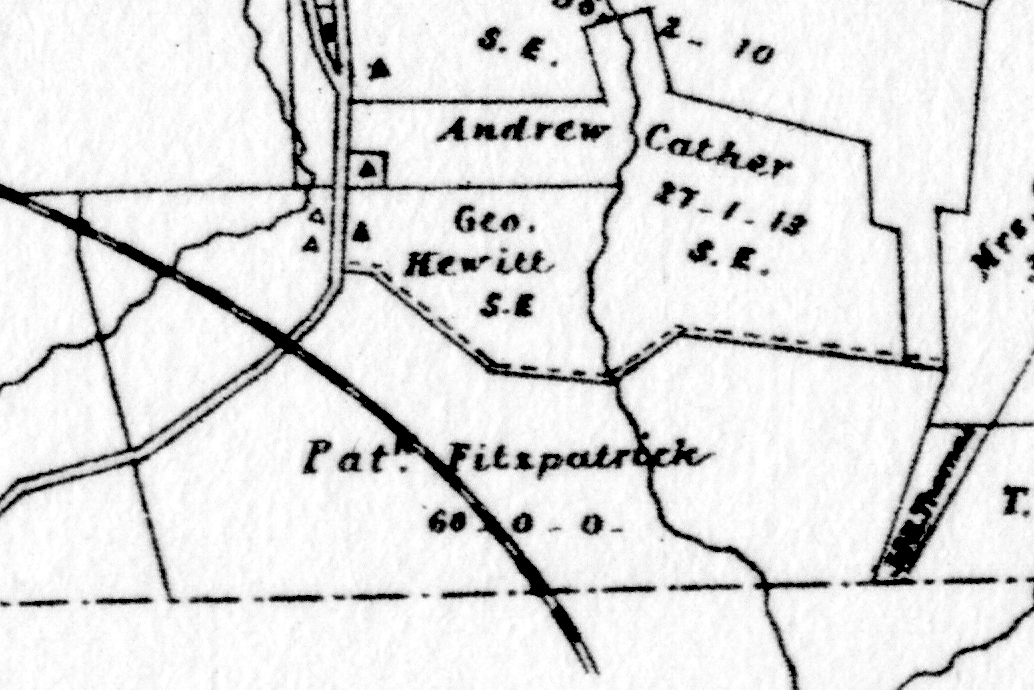
Patrick Fitzpatrick |
11/18/1880 |
42a 37p & 13a 71p |
$22,270 |
J9-48 |
Patrick Fitzpatrick |
|
1883 |
60a |
|
Breou |
|
Rosanna Logen et al (heirs of Patrick Fizpatrick) |
Sarah A. Hughes |
8/17/1885 |
11.6a & 0.875a |
|
B10-1 |
Henry D. & Sarah A. Hughes of Radnor |
Alvin A. Parker of Radnor |
10/11/1894 |
1.553a |
$6,500 |
K11-154 |
Sheriff (property of Alvin A. Parker) |
Joseph B. Bloodgood |
|
|
|
Sheriff’s Deed 14-35 |
Joseph B. Bloodgood |
Henry D. Riley |
11/23/1900 |
1.553a |
$7,500 |
E12-15 |
William E. Lewis |
Henry D. Riley |
4/25/1901 |
|
|
G12-382 |
Pennsylvania Hall Association |
Henry D. Riley |
10/14/1907 |
|
|
Y12-292 |
|
|
|
|
|
|
Heirs of Patrick Fitzpatrick, Louis McGrath et al |
Charles Gano of Haverford |
7/22/1925 |
34.781a |
$56,519 12c |
Y16-142; see table K3.2.1 for continuation |
Table K.4 Benjamin Davis
From |
To |
Date |
Area |
Cost |
Reference |
|
|
|
|
|
|
Benjamin Davis |
Robert Grover |
5/14/1793 |
107¼a 2p |
£600 |
I2-86 |
Robert Grover |
|
1795 - 1799 |
100a |
|
tax |
Robert Grover |
|
1798 |
99a |
|
Glass tax |
Robert Grover |
|
1809 |
|
|
died intestate; Ann Grover & John Read administrators |
|
|
|
|
|
See table AO.4 for tracts of 2 and 7 acres |
George & Sarah (nee Grover) Lewis |
Elizabeth, Mary, Margaret, Ann, Thomas J. Gover |
1/19/1833 |
1/6 part of 107a 42p |
$890 52c |
G4-235; release |
Patrick Fitzpatrick |
|
1883 |
60a |
|
Breou’s Atlas |
George Hewitt |
|
1883 |
not given |
|
Breou’s Atlas |
Andrew Cather |
|
1883 |
not given |
|
Breou’s Atlas |
|
|
|
|
|
|
Benjamin Davis |
Susannah Evans, daughter |
|
|
|
|
Susannah Evans |
Sarah Morgan, Hannah Davis (daughters) |
1792 |
|
|
Died; will 8/12/1789 |
Hannah Davis |
Jonathan & Sarah Davis (children) |
|
|
|
Died; will 3/19/1793 |
Isaac Morgan (husband of Sarah) |
|
1798 |
71a |
|
Glass tax |
Isaac Morgan |
|
1806 |
|
|
Died |
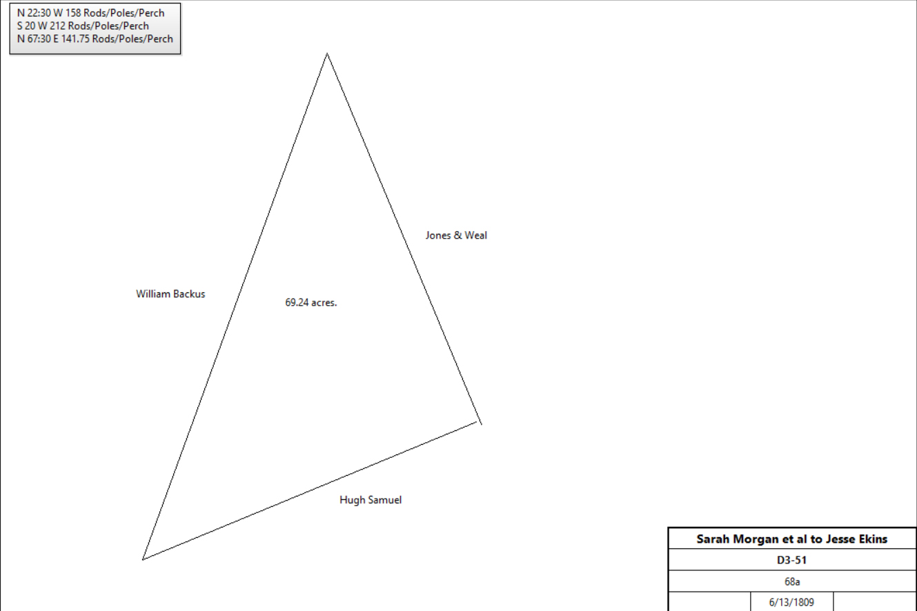
Sarah Morgan, Jonathan & Sarah Davis |
Jesse Ekins |
6/13/1809 |
68a |
£775 |
D3-51 |
|
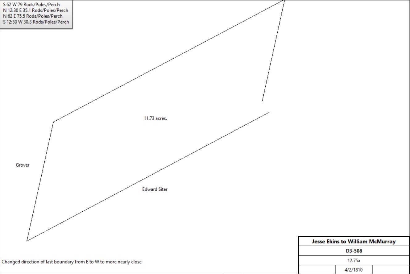
Jesse & Margaret Ekins |
William McMurray |
4/2/1810 |
12.75a |
$468 50c |
D3-508 |
|
William McMurray |
Margaret McMurray |
1855 |
Area not given |
|
Will; bequeath all my estate to my daughter Margaret |
|
|
|
|
|
|
Jesse & Margaret Akins |
John Garber |
4/2/1810 |
15a |
|
E3-116 |
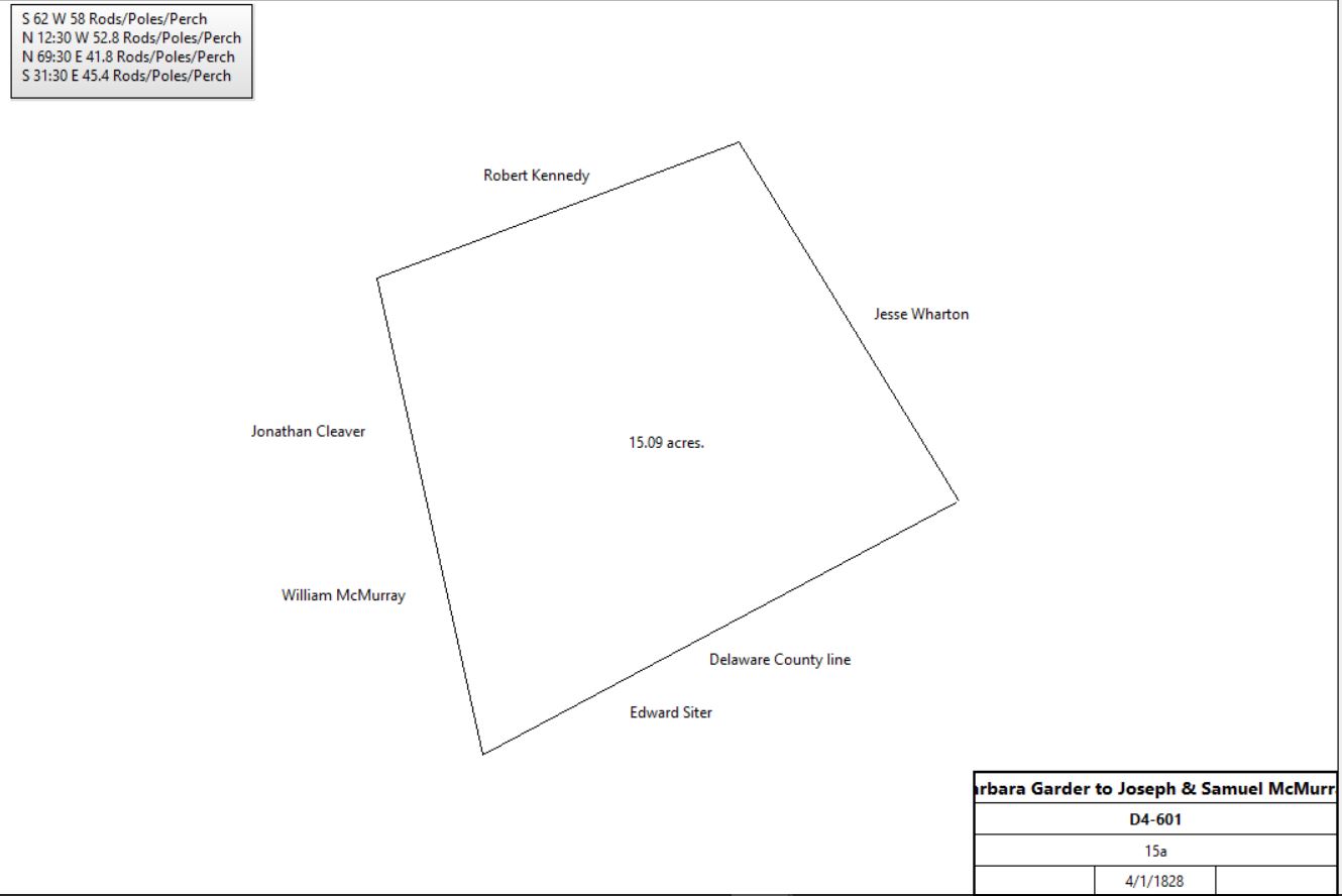
Barbara Garber, administrix of estate of John Garber |
Joseph & Samuel McMurray |
4/1/1828 |
15a |
$150 |
D4-601 |
|
Joseph & Samuel McMurray |
Andrew Borman |
7/5/1830 |
15a |
$255 |
D4-603 |
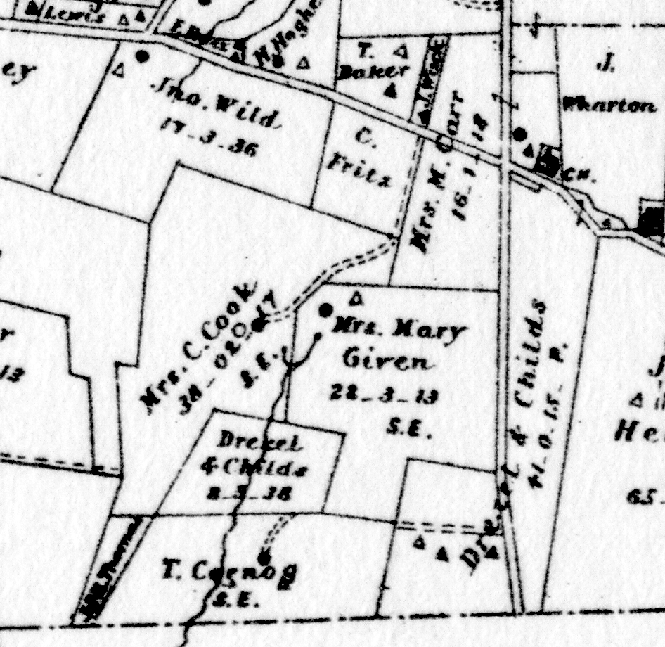
T. Cornog |
|
1883 |
Area not given |
|
Breou’s Atlas |
Drexel & Childs |
|
1883 |
8a 3r 38p |
|
Breou’s Atlas |
Mrs C. Cook |
|
1883 |
Area not given |
|
Breou’s Atlas |
Mrs. Mary Given |
|
1883 |
28a 3r 13p |
|
Breou’s Atlas |
Mrs. M. Carr |
|
1883 |
Area not given |
|
Breou’s Atlas |
C. Fritz |
|
1883 |
Area not given |
|
Breou’s Atlas |
|
|
Table K.4.1
From |
To |
Date |
Area |
Cost |
Reference |
|
|
|
|
|
|
heirs of Robert Kennedy |
Andrew Bowman |
4/11/1834 |
78a 50p |
$918 65c |
H4-394 |
Andrew Bowman |
Elizabeth Mullen |
3/14/1850 |
10a |
$500 |
L5-449 |
Joseph Mullen, administrator of the estate of Elizabeth Mullen |
Henry Root |
2/10/1874 |
10a |
$700 |
K8-452 |
|
|
|
|
|
|
Rees Rambo & Joseph Siter, executors of the will of Jacob Huzzard |
John Mullen |
3/31/1823 |
41a 10.5p + 1a 32p |
$498 90c |
N4-247; see table K.5 for earlier history |
|
|
|
|
|
|
Elizabeth, Mary, Margaret & Ann Grover |
Thomas J. Grover |
3/2/1835 |
107a 42p |
$4,290 50c |
Release, Miscellaneous 3-47 |
Thomas J. & Eliza Grover |
John Mullen |
3/3/1835 |
4½a 15p |
$238 87.5c |
N4-249 |
 |
Thomas J. & Eliza Grover |
Hugh Jones |
3/23/1837 |
73a 1r 22p |
$4,313 92c |
N4-443 |
Hugh Jones |
Jonathan Moore |
4/10/1843 |
60a |
$3,700 |
I5-567 |
Margaret Moore, widow of Jonathan Moore |
James Minshall |
3/27/1856 |
60a |
$5,500 |
A6-288 |
James & Hannah Seery |
Owen Seery |
4/1/1861 |
60a |
$7,150 |
P6-431 |
Owen & Catharine Seery |
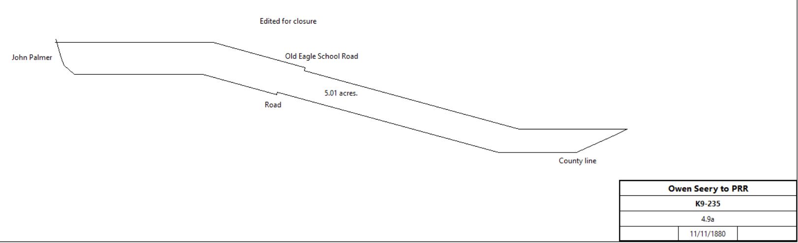
Pennsylvania railroad |
11/11/1880 |
4.9a - 0.236a |
$1,500 |
K9-235; land either side of railroad |
|
Owen & Catharine Seery |
Patrick Fitzpatrick |
11/18/1880 |
42a 37p + 13a 71p |
$22,270 |
I9-48 |
Patrick Fitzpatrick |
Pennsylvania railroad |
3/31/1882 |
0.778a + 0.764a |
$616 80c |
P9-222; land starting at western abutment of bridge; location of Strafford station |
Patrick Fitzpatrick |
|
1883 |
55a |
|
Breou’s atlas |
|
|
Table K.5 Huzzard
|
From |
To |
Date |
Area |
Cost |
Reference |
|
|
|
|
|
|
Timothy Davis |
David Pugh |
10/19/1717 |
150a |
|
Deed history from D2-41 |
David & Katherine Pugh |
Lewis Evans |
5/1/1723 |
150a |
|
Deed poll |
Lewis Evans |
|
4/16/1733 |
|
|
Will |
Executors of Lewis Evans (Thomas Morris, William George & John David) |
Thomas Lloyd |
7/9/1739 – 7/10/1739 |
150a |
|
Lease & release |
Thomas & Esther Lloyd |
John Davis |
11/16/1740 |
150a |
|
|
John Davis |
Sampson Davis (son) |
1/1/1765 |
150a |
|
died |
Sampson & Sarah Davis |
Jacob Sharraden aka Giradin |
3/16/1765 |
150a |
|
The History of Old Eagle School by Henry Pleasants (available as a free Google ebook)
North of Strafford station |
Jacob Sharadon |
|
1767 |
150a |
|
Tax |
Jacob Sharraden |
Christian Workizer (son-in-law) |
29/3/1767 |
150a |
|
The History of Old Eagle School by Henry Pleasants
North of Strafford station |
Christian Workizer |
Michael Watts |
4/10/1771 |
Part of 150a |
|
The History of Old Eagle School by Henry Pleasants. See table K.2.2 |
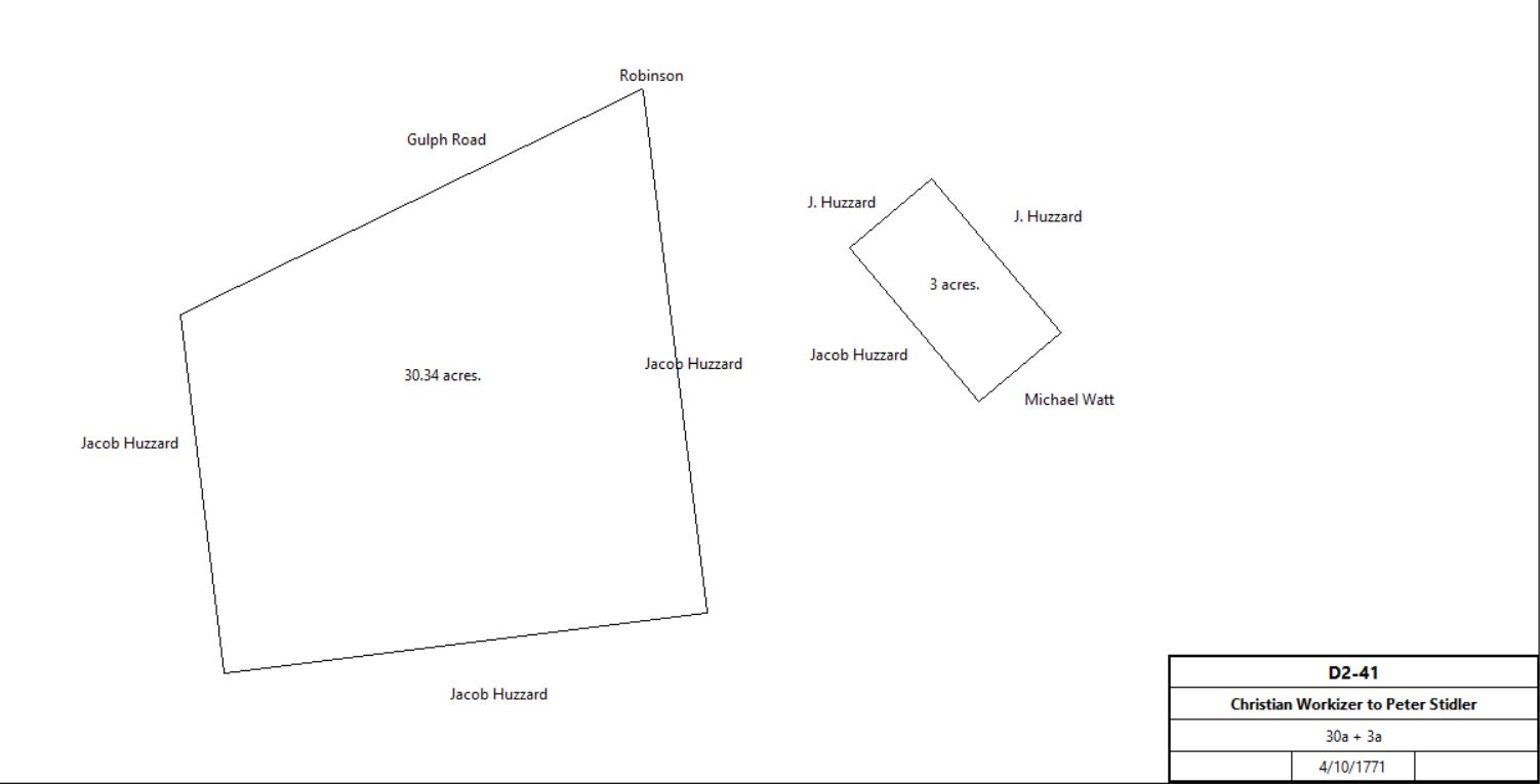
Christian & Margaret Workizer |
Peter Stiteler (weaver) |
4/10/1771 |
30½a & 3a |
£100 |
D2-41; see deed plan. The History of Old Eagle School by Henry Pleasants.
On the Gulph Road adjoining lands of Jacob Huzzard, and (3a) adjoining land of Michael Watts |
|
Mort. Peter Stiteler ux |
Christian Workizer |
1771 |
30&3a |
|
R-314 see table K.5.1 |
Christian Workizer |
Jacob Huzzard |
4/10/1771 |
106a |
|
The History of Old Eagle School by Henry Pleasants
Adjoining lands of Peter Stiteler & Michael Watts |
Jacob Huzzard |
Christian Workiser |
1771 |
106a |
|
R-317 mortgage |
Jacob Huzzard |
|
1781 |
106a |
|
Tax |
Jacob Huzzard |
|
1783 |
106a |
|
Tax |
Jacob Huzzard |
|
1785 |
100a |
|
Tax. Weaver |
Christian Workizer |
|
1785 |
|
|
Died ref: The History of Old Eagle School by Henry Pleasants |
Jacob Huzzard |
|
1786 |
100a |
|
Tax. |
Jacob Huzzard |
|
1787 |
100a |
|
Tax. |
Jacob Huzzard |
|
1788 |
100a |
|
Tax. |
Jacob & John Huzzard |
|
1789 |
100a |
|
Tax. |
Jacob Huzzard |
|
1791 |
100a |
|
Tax. |
Jacob Huzzard |
Heirs: Elizabeth, Jacob, John, Rudolf, Henry & Samuel |
|
|
|
Died |
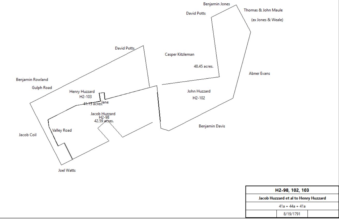
Elizabeth & John McAfee , John, Rudolf, Henry & Samuel Huzzard |
Jacob Huzzard |
8/19/1791 |
41a 10½p, part of 106a |
£214 10s |
H2-98; see deed plan |
John McAfee et al |
John Huzzard |
8/19/1791 |
44a |
£143 |
H2-101; see deed plan |
John McAfee et al |
Henry Huzzard |
8/19/1791 |
41a 10.5p |
£143 |
H2-103; see deed plan |
 |
Jacob Huzzard |
|
1795 |
33a |
|
Tax. |
John Huzzard |
|
1795 |
33a |
|
Tax. |
Henry Huzzard |
|
1795 |
33a |
|
Tax. |
Rudolph Huzzard |
|
1795 |
25a |
|
Tax. |
Jacob Huzzard |
|
1797 |
33a |
|
Tax. |
John Huzzard |
|
1797 |
33a |
|
Tax. |
Henry Huzzard |
|
1797 |
33a |
|
Tax. |
Rudolph Huzzard |
|
1797 |
25a |
|
Tax. |
Jacob Huzzard |
|
1798 |
40a |
|
Tax. |
John Huzzard |
|
1798 |
40a |
|
Tax. |
Henry Huzzard |
|
1798 |
40a |
|
Tax. |
Rudolph Huzzard |
|
1798 |
25a |
|
Tax. |
Jacob Huzzard |
|
1798 |
39a |
|
Glass tax; neighbor John Huzzard |
John Huzzard |
|
1798 |
|
|
Glass tax; neighbor Jacob Huzzard |
Rudolph Huzzard |
|
1798 |
65a |
|
Glass tax; neighbor Joseph Connard; occupied by Henry Huzzard |
Rudolph Huzzard |
Jacob Huzzard |
7/1/1798 |
1a 32p |
|
E3-112 |
Jacob Huzzard |
|
1799 |
40a |
|
Tax. |
John Huzzard |
|
1799 |
40a |
|
Tax. |
Rudolph Huzzard |
|
1799 |
65a |
|
Tax. |
Jacob Huzard |
|
9/27/1819 (probate) |
|
|
Will dated 7/1/1819 |
Rees Rambo & Edward Siter, executors of the will of Jacob Huzzard |
John Mullen |
3/31/1823 |
41a 10.5p + 1a 32p |
$498 90c |
N4-247 |
Rees Rambo & Edward Siter, executors of the will of Jacob Huzzard |
John Remington |
4/8/1825 |
3a 17p |
$240 |
Y3-135 |
|
Table K.5.1
|
From |
To |
Date |
Area |
Cost |
Reference |
|
|
|
|
|
|
Mort. Peter Stiteler ux |
Christian Workizer |
1771 |
30 & 3a |
|
R-314 |
Peter Stiteler |
|
1778 |
30a |
|
Tax |
Peter & Eve Stiteler |
Casper Kitselman |
4/24/1792 |
30 & 3a |
£200 |
G2-233 |
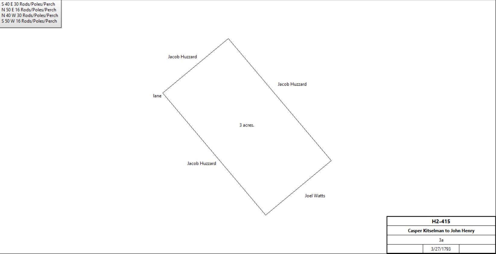
Casper Kitselman |
John Henry |
3/27/1793 |
3a |
$50 |
H2-415 |
|
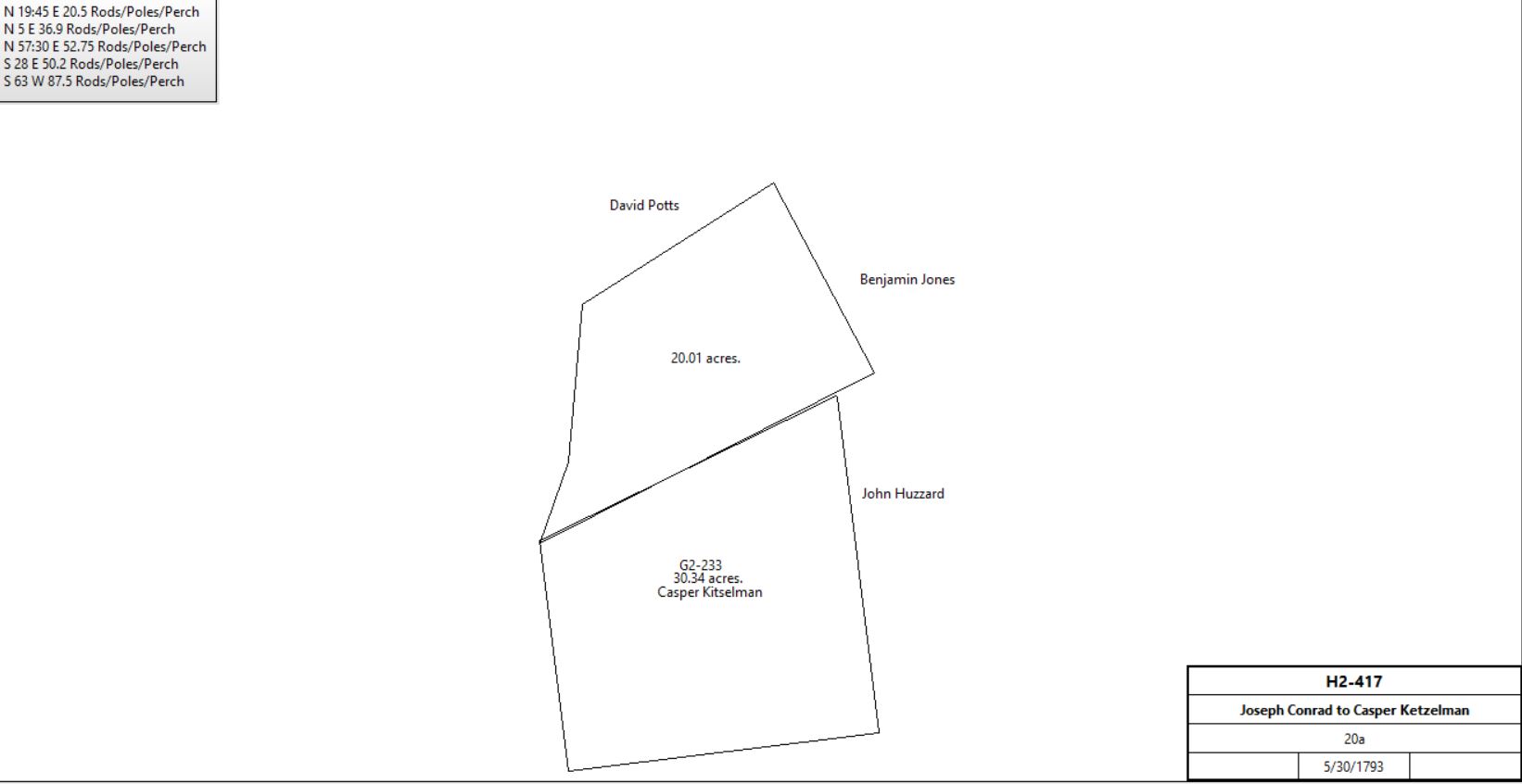
Joseph & Martha Conard |
Casper Kitselman |
5/30/1793 |
20a |
£50 |
H2-417 |
|
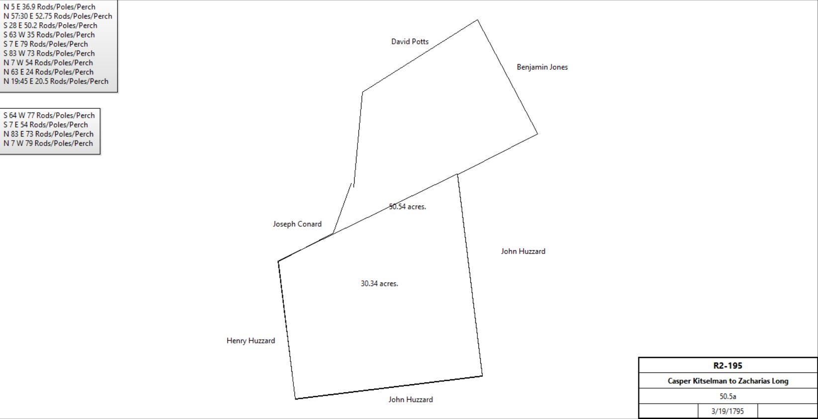
Casper & Hannah Kitselman |
Zacharias Long |
3/19/1795 |
50½a |
£365 |
R2-195 |
|
Zacharias Long |
|
1798 |
50a |
|
Glass tax; neighbor Joseph Conard |
Zacharias (innkeeper) and Sarah Long of Upper Merion |
William Davis of Radnor |
3/7/1806 |
50½a |
$1,800 |
B3-23 |
John & Catharine Henry of Tredyffrin |
Abijah Bowen |
3/28/1811 |
3a |
$195 |
E3-480 |
William & Mary Davis |
Joseph Ridgway & William Brown |
3/28/1814 |
45½a |
$4,500 |
K3-276 |
William & Hannah Brown |
Joseph Ridgway |
12/30/1814 |
45½a |
$2,250 |
K3-359 |
Jesse Sharp, sheriff, debt of Joseph Ridgway |
Issac Morris & Samuel Bettle (execs and trustees of Anne Atmore) |
3/14/1823 |
45½a + 55a 59p |
$1,450 |
A4-390 |
Issac & Sarah Morris and Samuel & Jane Bettle |
Robert Kennedy |
1/29/1824 |
45½a + 55a 59p |
$1,588 90c |
A4-392 |
| |
Robert Kennedy |
Jesse Carver |
1/1/1828 |
14a 100p |
$731 25c |
A4-186 |
Jesse & Hannah Carver |
Edward Suplee |
1/1/1828 |
14a 100p |
$731 25c |
F4-93 |
Edward & Rebecca Suplee |
William Biddle (Bittle) |
3/24/1840 |
14a 100p |
$1,100 |
T4-66 |
William & Margaret Bittle |
George Bittle |
8/17/1852 |
15a 23p |
$1,400 |
T5-534 |
George & Anna Maria Bittle |
Samuel Bittle |
4/28/1860 |
6a |
$500 |
P6-123 |
George & Ann M. Bittle |
Leonard F. Bittle |
5/10/1865 |
9a |
$1,000 |
B7-133 |
| |
Heirs and representors of Robert Kennedy, deceased |
Andrew Bowman |
4/11/1834 |
78a 50p |
$1,918 65c |
H4-394 |
Andrew Bowman |
Elizabeth Mullen |
3/14/1850 |
10a, part of 78a |
$500 |
L5-449 |
Andrew Bowman |
John Wilds |
3/28/1850 |
22.25a 26p, part of 78a |
$1,120 62c |
L5-575 |
Andrew Bowman |
Samuel Bittle |
3/28/1850 |
45.25a 25p (33.5a 12p part of 78a) |
$3,137 |
N5-367 |
Samuel Bittle |
Ann Eliza Givins |
5/28/1851 |
42a 7p |
$1,000 |
O5-282 |
|
Samuel & Ann Eliza Givins |
John Green |
2/16/1854 |
42a 7p |
$1,000 |
T5-596 |
John Green |
Thomas H. Cooke |
3/21/1857 |
42a 7p |
$3,150 |
G6-66 |
Thomas H. Cooke jr. |
Harry M. Cooke |
1/27/1887 |
42a 7p |
$658 |
C10-298 |
1887 atlas
|
|
|
|
|
|
|
John & Rachel Wilds |
Henry Fritz |
3/17/1860 |
4.5a |
$360 |
P6-214 |
Henry & Mary Fritz |
Caroline Fritz |
4/2/1867 |
4.5a |
$400 |
H7-95 |
|
|
|
|
|
|
|
Table K.5.2
|
From |
To |
Date |
Area |
Cost |
Reference |
|
|
|
|
|
|
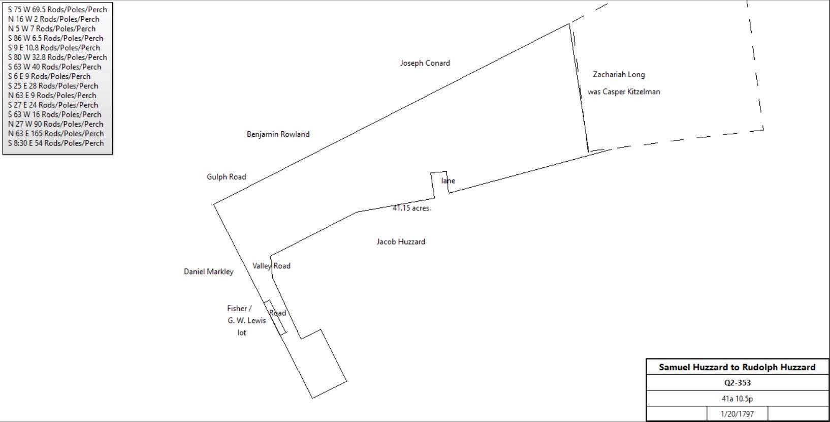
Henry & Elizabeth Huzzard |
Samuel Huzzard |
5/15/1795 |
41a 10.5p |
£179 14s 6d |
M2-145 |
Samuel Huzzard, carpenter |
Rudolph Huzzard, blacksmith |
1/20/1797 |
41a 10.5p |
£340 |
Q2-353 |
|
Rudolph & Mary Huzzard |
Francis & Abigail Fisher |
12/30/1814 |
41.25p |
$13 |
M3-155 |
Francis & Abigail Fisher |
Joseph Davis |
9/27/1823 |
41.25p |
$50 |
X3-444 |
Joseph Davis |
Elizabeth Davis |
3/12/1825 |
41.25p |
$50 |
X3-445 |
Elizabeth Davis, widow |
George W. Lewis, laborer |
4/18/1835 |
41.25p |
$375 |
K4-235 |
George W. & Sarah Lewis |
Elizabeth Lewis |
4/1/1854 |
41.25p |
$375 |
V5-189; messuage |
George W. Lewis, administrator of the estate of Elizabeth Lewis |
Elijah Brooke |
3/17/1862 |
41.25p |
$275 |
T6-520 |
|
Table K.5.2.a John Quigley tract
|
From |
To |
Date |
Area |
Cost |
Reference |
|
|
|
|
|
|
Rudolph Huzzard |
|
1817 |
|
|
died |
Rudolph Huzzard |
|
1879 |
|
|
died intestate |
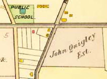
John M. Wilson, administrator of the estate of Rudolph Huzzard |
John Quigley, railroad boss |
3/31/1880 |
28a 158a |
$1,960 |
G9-256 |
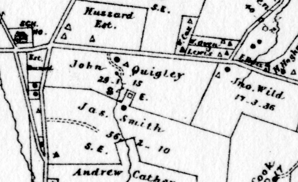
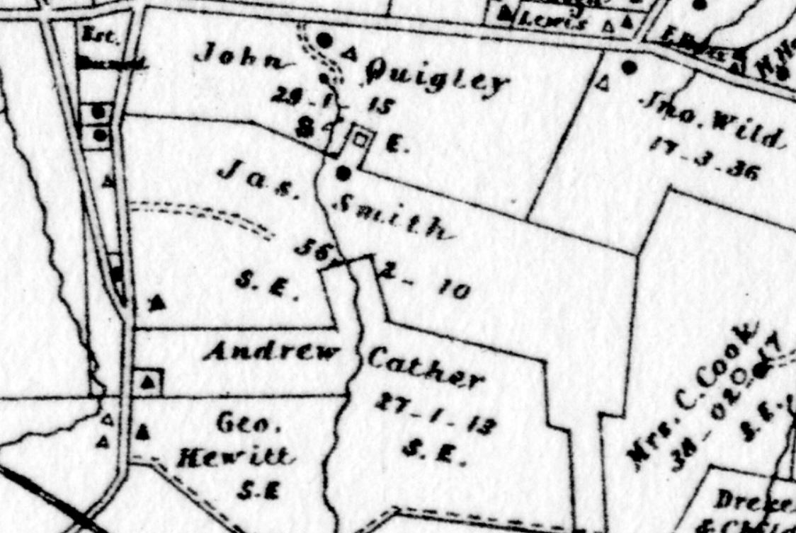
Extract from Breou's 1883 atlas
|
John & Eliza Quigley |
John Smith |
5/5/1885 |
1,620 ft2 |
$200 |
F10-34 |
Thomas McNeil & John Pechin, administrators of the estate of John Quigley |
George F. Quigley |
12/31/1904 |
28a 158p |
$16,100 |
X12-345 |
George Quigley |
Murdock Kendrick |
1/31/1906 |
10a - 1,626 ft2 |
$1 |
Y12-65 |
George Quigley |
Thomas McNeill |
6/29/1908 |
7.334a + 10.4a |
$1 |
O13-51 |
Thomas McNeill |
Edward Quigley |
6/29/1908 |
7.334a + 10.4a |
$1 |
O13-53 |
|
Table K.5.3 - Mullen tract
|
From |
To |
Date |
Area |
Cost |
Reference |
|
|
|
|
|
|
|
|
|
|
|
|
Jacob & Joseph Mullen, executors of the will of John Mullen |
Henry Root |
2/10/1874 |
41a 10.5p + 1a 32p + 4½a 15p |
$5,650 |
K8-455 |
Henry Root |
Joseph Mullen |
2/10/1874 |
41a 10.5p + 1a 32p + 4½a 15p + 10a |
$6,350 |
L8-91 |
Joseph & Sarah Mullen |
Robert Smith |
3/29/1882 |
41a 10.5p + 1a 32p + 4½a 15p + 10a |
$12,000 |
N9-399 |
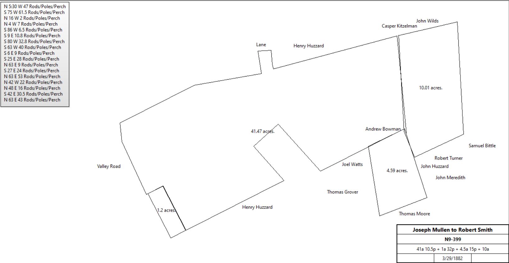
|
James Smith |
|
1883 |
56a 2r 10p |
|
Breou’s atlas |
| |
Table K.6 SE corner
|
From |
To |
Date |
Area |
Cost |
Reference |
|
|
|
|
|
|
Timothy Davis |
? |
|
50a |
|
|
Griffith Jenkins |
|
1729 - 34 |
|
|
tax |
Mary Jenkins |
|
1735& 39 |
|
|
tax |
Mary Jenkins |
|
|
50a |
|
Quit rent roll |
? |
Abner Evans |
|
|
|
Deed not found |
Abner Evans |
|
1796 |
50a |
|
tax |
Abner Evans |
Susannah Evans |
|
|
|
Died; no will or administration found |
Susannah Evans |
Sarah Morgan, Hannah Davis (daughters) |
1792 |
|
|
Died; will 8/12/1789 |
Hannah Davis |
Jonathan & Sarah Davis (children) |
|
|
|
Died; will 3/19/1793 |
Isaac Morgan (husband of Sarah) |
|
1798 |
71a (21a from Benjamin Davis?) |
|
Glass tax |
Isaac Morgan |
|
1806 |
|
|
Died |
Sarah Morgan, Jonathan & Sarah Davis |
Jesse Ekins |
6/13/1809 |
68a |
£775 |
D3-51 |
|
Table K.7 Strafford
|
From |
To |
Date |
Area |
Cost |
Reference |
|
|
|
|
|
|
The earlier history of this tract is described in Herb Fry's article on the Village of Spread Eagle |
J. Langdon Wentworth |
|
1883 |
125a |
|
|
Breou's Atlas, 1883
|
J. Langdon Wentworth |
|
1897 |
|
|
died age 91 |
Smith's Atlas, 1900
|
Biography of Martha Wentworth Suffren, courtesy of Radnor Historical Society |
|
|
|
|
|
D21-501 |
Sheriff |
Edmund Bayly Seymour |
|
|
|
sheriff's deed? X14-148 or 118 |
Edmund Bayly Seymour |
|
|
|
|
|
Provident Trust Company |
Eva B. Hayes |
1/26/1943 |
6.3a + other lots |
$6,000 |
D21-317 |
|
|
|
|
|
|
Josephine & Andrew Fritz |
Odd Fellows |
11/1/1910 |
|
|
|
Thomas Hoskins, trustee for Odd Fellows |
Gottdank Kotny |
9/12/1927 |
Lot #8, + Lot # 7½ - 0.21a |
$1,700 |
B17-194 |
Mueller's Atlas, 1913
|
|
|
|
|
|
|
Charles Wentworth et al, trustees of the estate of Martha Wentworth |
Martha W. Suffren |
6/18/1906 |
110.673a + |
$77,450 |
V12-558 |
Charles & Martha Wentworth Suffren |
Jean Humrichouse |
10/20/1910 |
2a |
$1 |
Z13-367 |
Lewis Minford & Jean Humrichouse |
Mary Huse |
7/27/1912 |
2a + 1.054a |
$1 |
F13-352 |
Harry & Mary Huse |
Gottdank Kotny |
3/25/1920 |
2a |
$16,460 |
P15-291 |
Railroad Atlas, 1926
|
Chester County Atlas, 1933
|
|
|
|
|
|
|
Martha Wentworth Suffern |
Martha W. S. Addoms & Edith S. Pitts |
12/2/1935 |
21.488a + 2.51a + ? + 3.4a |
$1 |
K19-97; gift |
Martha Wentworth Suffern et al |
Gottdank & Rose Kothny |
8/28/1939 |
3.4a |
$7,000 |
G20-182 |
|
|
|
|
|
|
Harold Durant |
Bryn Mawr Trust Company |
2/16/1926 |
|
|
mortgage book Q9-566 |
Aldus Seldom, sheriff, suite of Bryn Mawr Trust Company |
Catherine Hart & Mary McCusker |
4/26/1934 |
Lot #3 |
$1 |
B19-189 |
Catherine Hart & Mary McCusker |
Mon Dela Corporation |
5/26/1934 |
Lot #3 |
$1 |
L19-207 |
Mon Dela Corporation |
Gottdank Kotny |
10/14/1939 |
Lot #3 and 4 |
$1 |
B20-209 |
|
|
|
|
|
|
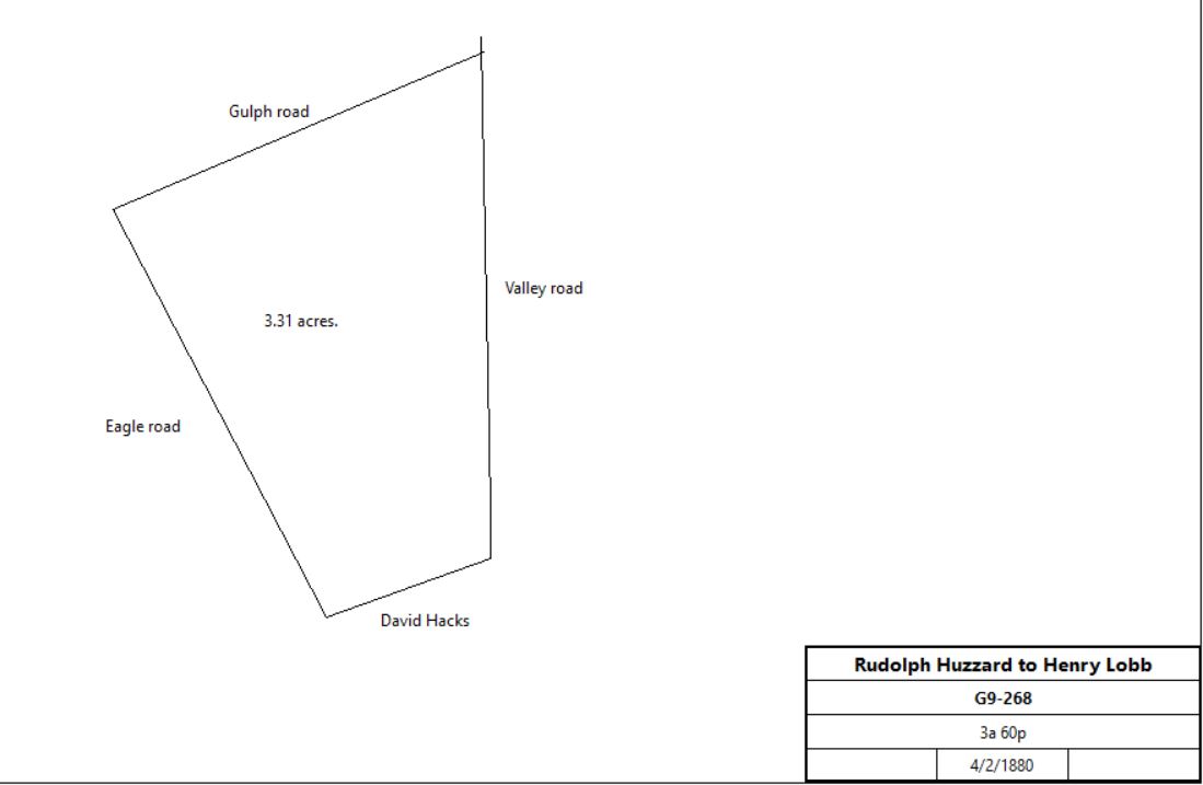
John M. Wilson, administrator of the estate of Rudolf Huzzard |
Henry Lobb |
4/2/1880 |
3a 60p |
$660 |
G9-268; see table K.5 for earlier history |
|
Henry Lobb |
Richard Hines |
4/3/1880 |
3a 60p |
$660 |
H9-91 |
Richard & Agnes Hines |
James Hines |
1/11/1890 |
0.462a |
$300 |
S10-135 |
Alice Hines, administrator of the estate of Richard Hines |
Mary A. Maguire |
4/7/1903 |
3a 60p - 0.462a |
$2,775 |
K12-291 |
Mary A. & John Maguire |
Josephine & Charles and Andrew Fritz |
6/9/1904 |
Lots #8 and 7½ |
$632 |
R12-133 |
Fritz tract, 1908
|
Josephine & Charles and Andrew Fritz |
PA Council #200, order of independent Americans |
12/26/1908 |
0.21a |
$350 |
S13-178; part lot #8 and lot #7½ |
PA Council #200, order of independent Americans |
Levi Dannaker |
6/29/1926 |
4.375 ft2 |
$350 |
H17-3 |
Levi Dannaker |
Gottdank Kotny |
1/23/1928 |
4.375 ft2 |
$1 |
T17-230 |
Gottdank & Rose Kotny |
John & Bridget McKenna |
5/1/1943 |
not quoted |
$1 |
F21-223 |
|
|
|
|
|
|
|
|
|
|
|
?14-72 |
Chester County Trust Company |
Charles W. Baily |
1/26/1917 |
0.462a |
$1 |
B15-128 |
Thomas Hoskins, trustee, Odd Fellows |
Gottdank Kotny |
9/12/1927 |
Lots #8 and 7½ |
$1,700 |
B17-194 |
Girard Trust Company, will of Charles Winter Baily |
Gottdank Kotny |
6/18/1942 |
not quoted |
$2,750 |
D21-41 |
Gottdank & Rose Kotny |
Vicenzo & Ida Recchilungo |
10/15/1942 |
14,146 ft2 |
$3,175 |
F21-138 |
Elizabeth Kothny |
John & Agnes Griswold |
11/3/1948 |
lots + 3.4a + 2a + Lot #8, + Lot # 7½ - 0.21a + lot on Woodland Road + 4,375 ft2 + lot on W. Valley Road - 14,146 ft2 |
$50,000 |
W22-260 |
John & Agnes Griswold |
Agnes Griswold |
2/20/1959 |
Lots #3 and 4, + 3.4a + 2a + Lot #8, + Lot # 7½ - 0.21a + lot on Woodland Road + 4,375 ft2 + lot on W. Valley Road - 14,146 ft2 |
$1 |
W30-547 |
Agnes Griswold |
Charles & Louise Baker |
6/1/1959 |
|
$32, 500 |
E31-55 |
Charles & Louise Baker |
George Bennyhoff & Judilee Traynor |
1/1/1984 |
|
|
P63-451 |
|
Table K.8 274 W. Valley Road
|
From |
To |
Date |
Area |
Cost |
Reference |
|
|
|
|
|
|
The earlier history of this tract is described in Herb Fry's article on the Village of Spread Eagle |
J. Langdon Wentworth |
|
1883 |
125a |
|
|
Breou's Atlas, 1883
|
J. Langdon Wentworth |
|
1897 |
|
|
died age 91 |
Smith's Atlas, 1900
|
|
|
|
|
|
|
Charles Wentworth et al, trustees of the estate of Martha Wentworth |
Martha W. Suffren |
6/18/1906 |
110.673a + |
$77,450 |
V12-558 |
Biography of Martha Wentworth Suffren, courtesy of Radnor Historical Society |
Charles & Martha Wentworth Suffren |
Jean Humrichouse |
10/20/1910 |
2a |
$1 |
Z13-367 |
Lewis Minford & Jean Humrichouse |
Mary Huse |
7/27/1912 |
2a + 1.054a |
$1 |
F13-352 |
Mueller's Atlas, 1913
|
Harry & Mary Huse |
Gottdank Kotny |
3/25/1920 |
2a |
$16,460 |
P15-291 |
Railroad Atlas, 1926
|
Chester County Atlas, 1933
|
Elizabeth Kothny |
John & Agnes Griswold |
11/3/1948 |
lots + 3.4a + 2a + Lot #8, + Lot # 7½ - 0.21a + lot on Woodland Road + 4,375 ft2 + lot on W. Valley Road - 14,146 ft2 |
$50,000 |
W22-260 |
John & Agnes Griswold |
Agnes Griswold |
2/20/1959 |
Lots #3 and 4, + 3.4a + 2a + Lot #8, + Lot # 7½ - 0.21a + lot on Woodland Road + 4,375 ft2 + lot on W. Valley Road - 14,146 ft2 |
$1 |
W30-547 |
Agnes Griswold |
Charles & Louise Baker |
6/1/1959 |
|
$32, 500 |
E31-55 |
Charles & Louise Baker |
George Bennyhoff & Judilee Traynor |
1/1/1984 |
|
|
P63-451 |
|
