|
|
Tredyffrin Easttown Historical Society Home
: Document Collection Home
Use the links at the left to return.
|
||||||||||
Document Collection |
||||||||||
Historic Newspaper Clippingsby Heidi Sproat and Mike BertramDid you know that in the 1800s there were properties in Tredyffrin township that when offered for sale, boasted an onsite marble repository? Or one with an “extensive strata of marble”? We’ve also heard about properties offered for sale touting limestone quarries, or access to the much sought-after lime product in the mid 1800s. Several ads offer both limestone quarries and associated kilns, notably in the Howellville area [Howeltown? Howelville?] 1 . Herb Fry passed away in 2018 at age 92. His family donated his collection to the Tredyffrin Easttown Historical Society. Many items in his priceless historical collection included over 200 newspaper clippings from the 1800s. Most of the clippings relate to Tredyffrin township properties, but there are a few from Charlestown2, Willistown3, and Upper Merion4. The clippings are not available online. Herb almost certainly copied the clippings from the Chester County Historical Society clippings files. Reading through the clippings, we decided that we needed to write an overview of the kinds of information provided. After a fashion, it became apparent that there were commonalities in language use, offering points of sale, and some just very interesting observations about property offerings. To that end, we wrote this article in hopes it would help present an overview of the clippings before a researcher dove in to review them individually. We came up with a plan to digitize the 200 plus clippings, transcribe them, and upload them to the Document Collection website (this link is listed on the front page of the tehistory.org website) so that both an image of the clipping appears with the companion transcription. Thus, the clippings are fully text searchable. Assuming one searches for the appropriate language of the era, a researcher should find some relevant information. For example, searching for a “messuage” is the term used for a dwelling house / dwellinghouse.
Typical Clippings showing the type of information provided Overall Property Descriptions Transcribing these clippings was no easy task. The copies are of poor quality, and tedious to read and transcribe, but once we got going, the language used at that time became routine. Why would we spend all this time working on such a laborious, monotonous exercise? The newspaper clippings provide some of the best information for property descriptions, accompanying assets/appurtenances, physical location, acreage size, owners, adjoining land owners, planted fruits like Apple Orchards and other species of trees, like Chesnut [Chestnut], cherry, pear, peach, prune, and plum 5, accessibility to water and if pumps are available, and terms of sale. There is even an entry promoting the benefits of a Hydraulic ram to bring water directly to the house6. The clippings specifically state if there are dwelling houses, stables, sheds, corn cribs, granaries, barns, spring, hay, hog, ice, wagon, or smoke houses, grist or saw mills, other out buildings, and “appurtenances.’ The clippings further note if the property was limed, when and how often, fenced, had cultivated plots of land, subject to Sheriff’s Sale, and so much more. (“Outbuildings” are separate but associated with a main building, near but subordinate to the main building, like an outhouse. Much of this information is unavailable elsewhere and is a treasure trove of information about given properties.) Professions and ties to Census Records In the period of these newspaper clippings Pennsylvania ran a census on a 7-year cycle. The census returns include occupations after 1807. In many cases it is possible to connect the sellers with their census records and find their occupations. For example: William Guthrie is listed as a storekeeper in the 1821 and 1828 census. In his 1838 advertisement he attempted to sell the store. By the early 20th century the store was known as Scofield’s store. There are photographs of the store in that time period in the image database [see Index] (search on ‘paoli corner’). It was located in the northwest quadrant of the junction of what is now routes 30 and 252 in Paoli. Samuel Beaver appears in the census as a miller. He tried to sell the Chesterbrook Mill in his advertisements from 1845 to 18547. These advertisements describe the mill, the associated mansion house, and the land. The connection between the occupations and advertisements is not always clear initially. Randal Evans is listed as a tanner (1821) but is advertising the Black Bear Inn for sale or rent in 1840. He did run a tan yard from his farm, but also owned the Black Bear, though he was not the licensee. In addition to the physical property descriptions is the added professional information about the sellers. Examples of sellers include blacksmith, saddler, and wheelwright . If one went back and checked out the 1840s or 1850s censuses (early local censuses), you will find references in the census records to many of these same individuals in these newspaper clippings listing the associated business operations in which they were engaged. For example, a Blacksmith shop for rent is offered for sale located near the “Eagle, at Mifflin Lewis’.”8 This is the Eagle Station and Hotel, which was located between Devon and Strafford; see The Station at Eagle, by Mike Bertram and Roger Thorne, TEHS Quarterly, vol. 56, #1 (2020) for a detailed history.Joseph Townsend shows up in the 1828 Census as a Shoemaker 9. There is a reference to James Foote’s land and checking the census he shows up as the Paoli Inn Innkeeper, but a lot earlier in 1814 10. Samuel Beaver and David Christman (Chrisman ?) show up as millers in both 1835 and 1842.
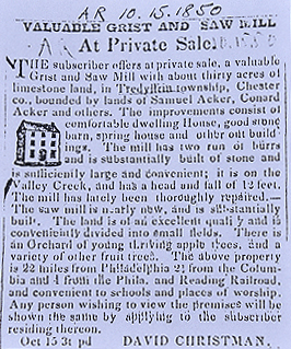
Chesterbrook Mill Property from Breou’s 1883 atlas, earlier owned by Samuel Beaver. David Christman purchased the Church Road Mill in 1834 11. In 1849 he tried to sell the Grist and Saw Mill – and he too appears in the 1835 and 1842 Septennial Census records as a miller.
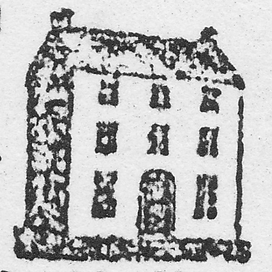
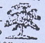
In the 1828 and 1835 census records, William Campbell shows up as a carpenter and his property is offered for sale in August 1853 12. In this instance, prospective purchasers are requested to inquire of B. Supplee (listed as a cooper in the 1842 census), or inquire at a downtown Philadelphia site. In the Campbell property case, parties are sent to inquire at “the corner of Broad and Green streets, Philadelphia.” Imagine seeking information like that today; or instructions to inquire at Broad St. “above Spruce, Philadelphia” from October 1850 13. Location, Location, Location Besides noting that properties for sale contained limestone, marble, timber land, woodland, meadows, and other characteristics, like a farm, or tavern, we discovered that ads placed in the newspapers American Republican (Baltimore, Maryland !), and Village Record (West Chester) in the 1840s specifically stated that properties were conveniently located to mills, transportation railroad options, places of public worship of different denominations, and nearby schools. Reviewing only one or two of the clippings alone doesn’t really offer any revelations, but reviewing many of them in chronological order gives credence to the developing social framework. For example, before 1830, there is no mention of availability to schools; after 1830 most clippings include this perceived sale advantage. In addition to translating the articles, which provides rich details of the properties, the deed histories and patent information have been searched, if available, noting the additional information on the same document for easy reference. An example is this 15 acre Tredyffrin property, within half a mile of the Spread Eagle, on the Philadelphia and Lancaster turnpike road. Links to the deed histories have been added where they are known. There are references to specific place names as we know them today: Swede’s ford (Swedesford), Cedar Hollow, Centreville, West Chester, Howeltown (Howelville?) (Howellville), Reesville (?) (Reeseville) 14 and others. Careful reading can often pretty much reveal what the place name is today. Even though there are proper names that appear to be misspelled, there was no standard spelling convention at the time. Surprisingly, all but two entries correctly spell one of the most difficult words – Tredyffrin. Even Schuylkill was spelled consistently correctly15. There are specific distances noted to the various railroad and road connections – Philadelphia and Columbia Railroad, the Philadelphia and Lancaster turnpike road 16. In one case the distance to a “good and constantly increasing market at Port Kennedy” is noted as being only “half a mile distant” 17. In another clipping18, also from 1851, a store stand and dwelling is advertised for rent. Notably, but unexpectedly, the ad boasts “There is no store within two miles of this place.” Certainly this is a favorable purchase factor for reduced competition. And in January 1852,19 a Lewis Watson is referred to as residing near the premises of a “well-known TAVERN STAND, farm and Limestone Quarries and Kilns in the Village of Howelville [sic]”. The same Lewis Watson appears on the Septennial Census as a Merchant in the 1835 and 1852 records. James Carr appears in a November 1851 advertisement as a neighbor of Samuel Givens and the same Mr. Carr appears in the 1814 and 1835 census records as a blacksmith [there was a blacksmith and other businesses at Howellville]. Limestone is Big Business The October 1852 Village Record entry promoting an Executor’s Sale of limestone land in the Great Valley boasts a “vein of copper ore runs through the 30 acre premises.” 20 In October 1853, an ad for a 60 acre tract of land claims there is an “Iron Ore” deposit on it. Likewise in November 1853, an “appearance of iron ore”, and “supposed to contain an abundance of iron ore”. There is also reference to both copper and “silver” being previously mined on the property. 21 Limestone and quarrying was big business in the Tredyffrin area, and thus many of the featured properties for sale added that information in the clipping. Of the 200-plus clippings, at least 53 properties boasted limestone capability on the property. Liming business was a vital endeavor at that time and this article addresses the use of limestone in Frederick County, p. 16, Maryland. The burning of lime made it useful for building material (mortar, plaster, pointing and stucco), as a road material, and for agricultural use. Lime also played a critical role in glass and iron production as flux. In describing the benefits of the physical properties, in one case we see the offering of a Spooling and Bobbin Factory 22, formerly used as a grist mill. Notably, the “fall” of the water on the mill is defined, in this case, the “head and fall of 33 feet”. Most of the other grist mills note falls of typically 12 feet 23, but there are two falls that are almost as high, 25 feet 24, and one at 28 feet 25. There is also mention of two “pairs of burs [burrs]” which is a type of siliceous rock used for millstones (reference to burs also noted) 26. In the case of a September 1853 sale advertisement for a Merchant and Grist Mill, there are “three run[s] of French Burrs, all nearly new, … with the necessary machinery, completely arranged for doing merchant and county work without interfering with each other.” 27 There are also references to properties being recently limed, or in one case, being “well limed every year” 28. In August 1853, 23 acres of land owned by Albert Watson were being sold. Watson also appears in the 1835 Census as a butcher. Adjacent property owner, Edward Schofield, appears in the 1821 Census as a “lime burner” and neighbor Adam Siter appears in the 1835 Census as a teacher 29. Reviewing volumes of newspaper clippings as we have, you also start to recognize repeated language patterns. Here are a few examples: when referring to spacious stone dwelling houses, they are “commodious”; to the quality of the land, in a “high state of cultivation, divided into convenient fields”; to water availability, a “never-failing spring” located near or in some cases under a home 30; location of property, “handsomely situated within a half mile of” railroads, or roads. As the ads progress in time, so does the language. An 1853 ad is the first time we saw the word “obviating” 30 referring to the large dam, substantially built and close to the mill, “thereby obviating the disadvantage and expense attending upon a head race …”. There are references to the Schuylkill Navigation in a number of clippings 32,33, 34. The Schuylkill Navigation was opened in 1825. It was a series of dams and locks and sections of canal along the river. Locally, there was a dam and lock at Pawlings. The Navigation allowed the transportation of coal from the upper Schuylkill to Philadelphia and other towns and cities. This transformed the provision of fuels. In 1841 the Reading railroad was opened providing competition to the Navigation. The railroad took over the navigation in 1870, but coal continued to be transported by water until the 1930s. There is a reference in the October 1853 ad for the property of Wm. Henry, deceased, where prospective buyers are directed to further inquire in East Whiteland township, “near the Steamboat.” 35 The Steamboat Inn was located at Glen Loch at the junction of the Lancaster and Phoenixville turnpikes. As technology advanced in the 1800s, these ads likewise reflected some of these new “inventions.” In a November 1853 entry the ad specifically boasts of “all the modern inventions for washing and other culinary purposes”. 36 As printing processes progressed, likewise did the artwork accompanying the ads. Starting in the 1840s, the printer in both Village Record and American Republican advertisements started to include eye-catching drawings of dwelling house renditions. They also included trees to indicate orchards. 37
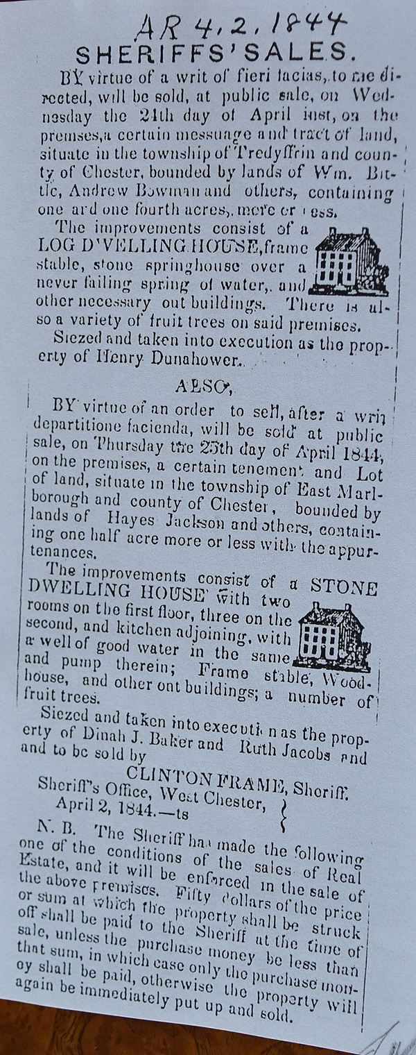
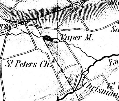
Sheriff’s Sales45 (23%) of the clippings were advertisements for Sheriff’s sales. These sales were ordered by two courts, the Quarter Sessions (later renamed the Common Pleas court) and the Orphan’s Court. The Quarter Sessions handled cases of debts (often concerning mortgages) while the Orphan’s Court handled the guardianship of minors, disputes over wills, and the appointment and overseeing of administrators of an estate when there was no will. In the case of the Quarter Sessions you will find the common use of a number of legal terms. Levari facias, a common-law writ of execution for the satisfaction of a judgment debt from the goods and lands of the judgment debtor; Fieri Facias 38, a writ of execution commanding the sheriff to levy and make the amount of a judgment from the goods and chattels of the judgment debtor; and venditioni exponas (Lat. that you expose to sale). In practice, the name of a writ of execution, directed to the sheriff, commanding him to sell goods or chattels, and in some states parcels of lands, which he has taken in execution by virtue of a fieri facias, and which remain unsold. Under this writ, the sheriff is bound to sell the property in his hands, and he cannot return a second time. Notable Groups of ClippingsClintonville (Cedar Hollow) Paper Mill See doc393, Philip Howell Patent & Purchase, Cedar Hollow for details.
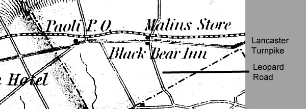
The Greenwood Farm, which was on West Valley Road, provides a good example of the information that clippings can provide. Here is the description of the property from 1833: 156½ Acres, 40 of which is woodland, the remainder arable and in a high state of cultivation. The farm is under good fence, and every field is supplied with water, by two brooks, one of which passes through the barn yard. There are on the premises a young bearing apple orchard of well selected fruit, and within an enclosure, near the mansion, a variety of apricot, cherry, pear, peach, green gage, egg plum, pruin, and other fruit trees, in bearing order, as well as a diversity of grape-vines, which afford delicious fruit in their season. There are, moreover a lime kiln, a lime quarry and extensive strata of Marble. The buildings are a large stone Dwelling house, nearly new, and constructed in modern style, having a wide hall and four rooms on the first floor, six on the second, and five on the third, with a cellar under whole building, in five apartments, a large stone barn, wagon-house, carriage-house, hog-house, sheep-house, and other out buildings. Upon another part of the farm there is a good tenant house, having a kitchen and cellar in the basement story, three rooms on the second and two on the third, a cow-house with stalls for twenty cows, having a hay mow above and a rivulet passing through the cow-yard; and a spring-house over a strong spring of excellent water, which is unaffected either by drought, or rain, and sufficiently large to hold the milk of thirty cows. The above-described farm is situate one mile north of the Pennsylvania rail road, 15 miles from Philadelphia, fifteen from West Chester and six from Norristown. - At the road which passes from the Swedesford, through the farm to the Spread Eagle, on the Lancaster turnpike, divides the arable lands, the woodland, the streams of water and the buildings pretty equally, the property will be sold either in two tracts or one as may suit purchasers 39. Black Bear Inn / Tavern For the deed history, see the Hort-Wright Patents. This is the Black Bear Inn and tract.
See also TEHQ v31n1, p. 20 which has much more detail. The advertisements document the deteriorating financial situation of Randall Evans. He initially tried to rent or sell the Inn, then the property appears in a Sheriff’s sale. Documents which mention the sale (not rent) of the Black Bear include doc124, doc 126, doc127, doc128, doc545, doc552, doc553, and doc565. Dr. John Davis’ many properties While it may appear from the land sales that Dr. John Davis was on a property purchasing spree, the records reflect differently. Dr. John Davis’ father passed away intestate with three sons inheriting. One of the brothers, Benjamin, only received a small amount of property 40. The reason for this is unclear. Dr. John’s brother, Dr. Elijah Davis, who lived in Maryland, inherited a farm at the east end of Tredyffrin, but Elijah wound up selling his property to his brother John. Their mother was a Havard and Dr. John wound up inheriting additional property from his mother. The total acreage he owned was around 350 acres, making him the largest land owner in Tredyffrin at the time. Dr. John Davis then died intestate and it took the administrators of the estate many years to sell all of his property and unwind his financial affairs. Future work It is planned to further expand the digitized clippings collection, sourcing them from the Tredyffrin Easttown Historical Society Archives and/or the Chester County Historical Society clippings files. The location of the sales will be broadened to cover both Easttown and Tredyffrin townships. The clippings have been organized by Charlestown, Easttown, Schuylkill, and Tredyffrin townships at this link.An additional 29 newspaper clipping articles were recently added to the Document Collection. The new articles were for various mills, the Black Bear Inn and Tavern, the Lamb, Spread Eagle, Sign of the Stage, Howell's Tavern, the Franklin House, the Beidler - Beaver controversy, and business houses, including many clippings about the Mansion House at the Valley Forge Hotel. Of interest was the newspaper's publication about Innkeepers or Tavern Keepers who were considered to be of "good repute for honesty and temperance" (doc670), and "polite and attentive" (doc671). The advertisements encouraged visitors who "may wish to visit the old Camp Ground"; liquors "are of the best quality"; and the table "supplied from the best the market affords" (doc672). These considerations were repeated in many of the ads and thus were apparently important to visitors and travelers alike (doc672). Two thirds of these new 29 clippings are dated between 1850 and 1888, and they appear in the database as doc662-doc691. We also discovered two new words: "affray" means a brawl (doc674), and "to remove" means to relocate (doc681). Notes and ReferencesEndnotes below refer to specific document numbers, docxxx. For brevity, document addresses were truncated to refer to just the document number with an appropriate link.
|